
.gif)
Tropical Storm Amelia (1978)
Encyclopedia
Tropical Storm Amelia was a weak, poorly-organized tropical storm that caused a severe flooding disaster in Texas
during the 1978 Atlantic hurricane season
. Amelia developed from a tropical wave on July 30 that entered an area of the Gulf of Mexico
that was conductive for tropical cyclogenesis
. After forming, the tropical depression quickly strengthened into a tropical storm just hours before making landfall
in Corpus Christi
. The storm lasted roughly a day over land before becoming unidentifiable.
Amelia affected the Texas coast for 2 days, causing several shipping incidents. However, the biggest impact from Amelia followed its dissipation, when its remnants contributed to record rainfall totals over the state. The rainfall caused several rivers and creeks to flood, specifically around the Texas Hill Country
. Overall, Amelia caused 33 fatalities with an estimated $110 million in damages.
coast on July 19. The system headed eastward through the Atlantic Ocean
for the next week with no change in development. After entering the Caribbean Sea
on July 26, convection began to come together two days later due to the influence of anticyclonic flow
. The disturbance passed the Yucatan Peninsula
on July 29 and entered the Gulf of Mexico
. No circulation was found in the developing system, however.
On July 30, the disturbance turned to the northwest and entered an area of the Gulf with slightly above normal sea surface temperatures
and low vertical wind shear
, which favored further development of the disturbance. At this point, the presentation seen on satellite had indicated that a tropical cyclone was beginning to form in the Gulf. After a reconnaissance aircraft went into the system, the cyclone was upgraded into a tropical depression that afternoon, the seventh of the season. Several hours later, the depression was upgraded to Tropical Storm Amelia, a decision that one forecaster said was made "to be on the safe side". Amelia peaked at 45 miles per hour (72.4 km/h) in wind speed, with the system beginning to skirt the Texas
coast. At peak intensity, the storm had gale-force winds along a diameter of 150 mi (241.4 km).
Amelia, which never had a well-defined center, went up the coast during the afternoon and evening of July 30, making landfall in Corpus Christi
the next day. The system was tracked until passing just west of San Antonio
, where it became indiscerible after the morning of August 1. The storm was active for a short span of time — just under two days — forming and dissipating so quickly that, following the storm, there was some controversy about the reliability of the weather forecasters.
 As Amelia approached the Texas
coast, gale warnings were issued for the area from Brownsville
to Port O'Connor
on July 30. As the state had been in the midst of a severe drought the previous six weeks, there was hope that the storm would relieve the dry conditions.
Effects from Amelia ranged from 38 miles per hour (61.2 km/h) winds in Brownsville to gusts of up to 58 miles per hour (93.3 km/h) in Corpus Christi. In coastal areas of Texas
, damage was limited to the sinking of several shrimp boats and the beaching of sail boats. In addition, some trees and fences were blown down, though damage was relatively minor. There were about 30 fatalities reported from flooding in Texas, with devastating damage to the areas affected by the storm. South Padre Island reported power outages after receiving over 4 inches (101.6 mm) of rain.
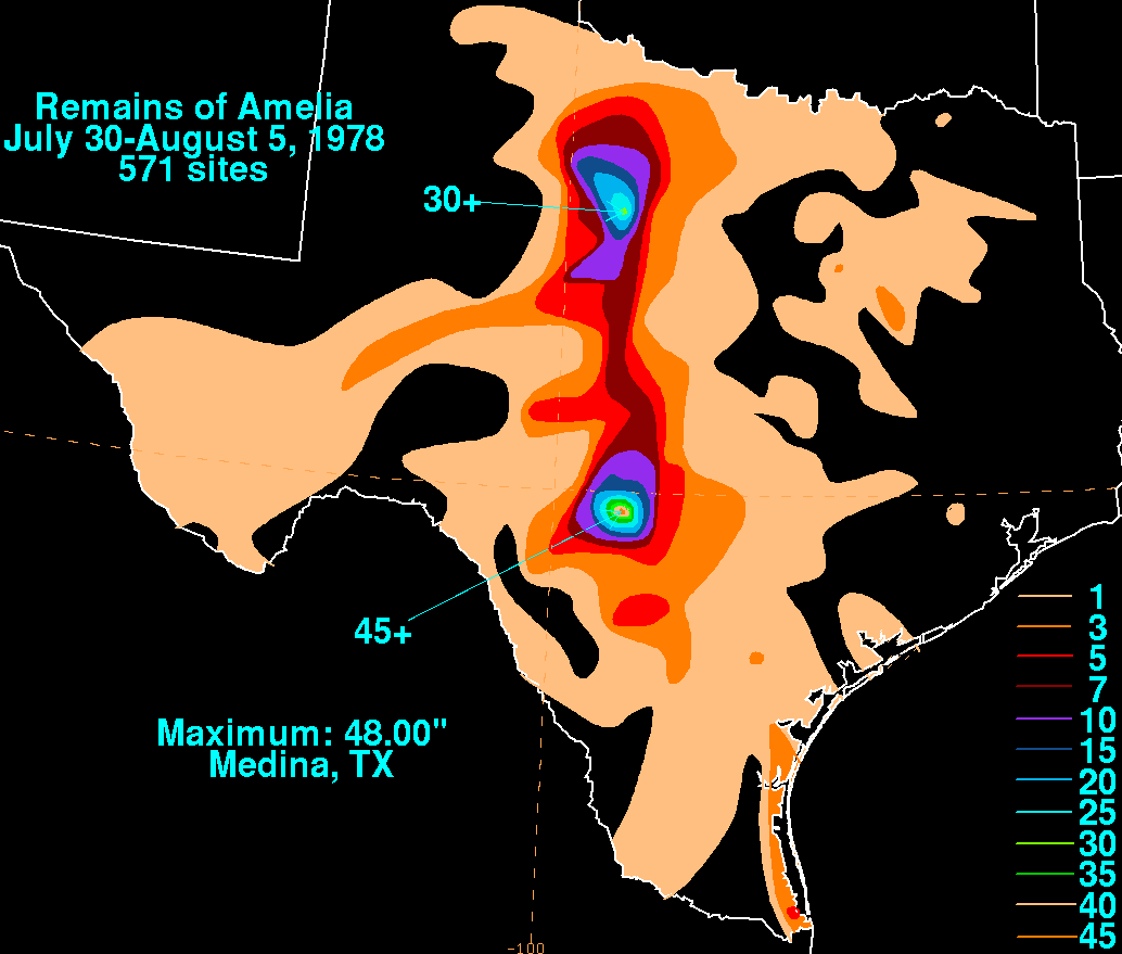
Inland Texas fared much worse, though. The continuous flow of tropical moisture during Amelia's dissipation and remnant stage brought heavy flooding for two and three days. The orographic effect of the Edwards Plateau
enhanced the flooding, leading to rainfall totals as high as 30 inches (762 mm) in a two-day period. The worst hit area was the Guadalupe River
basin and its tributaries, though many other rivers overflowed, contributing to the overall impact of the storm. A 12-hour total of 26 inches (660.4 mm) of rain at Abilene
was an extreme example of the precipitation. The storm total of 48 inches (1,219.2 mm) measured at Medina is the wettest known storm total rainfall amount for both the state of Texas
, as well for any tropical cyclone impacting the continental United States
.
Texas
Texas is the second largest U.S. state by both area and population, and the largest state by area in the contiguous United States.The name, based on the Caddo word "Tejas" meaning "friends" or "allies", was applied by the Spanish to the Caddo themselves and to the region of their settlement in...
during the 1978 Atlantic hurricane season
1978 Atlantic hurricane season
The 1978 Atlantic hurricane season officially began on June 1, 1978, and lasted until November 30, 1978. These dates conventionally delimit the period of each year when most tropical cyclones form in the Atlantic basin...
. Amelia developed from a tropical wave on July 30 that entered an area of the Gulf of Mexico
Gulf of Mexico
The Gulf of Mexico is a partially landlocked ocean basin largely surrounded by the North American continent and the island of Cuba. It is bounded on the northeast, north and northwest by the Gulf Coast of the United States, on the southwest and south by Mexico, and on the southeast by Cuba. In...
that was conductive for tropical cyclogenesis
Tropical cyclogenesis
Tropical cyclogenesis is the term that describes the development and strengthening of a tropical cyclone in the atmosphere. The mechanisms through which tropical cyclogenesis occurs are distinctly different from those through which mid-latitude cyclogenesis occurs...
. After forming, the tropical depression quickly strengthened into a tropical storm just hours before making landfall
Landfall (meteorology)
Landfall is the event of a tropical cyclone or a waterspout coming onto land after being over water. When a waterspout makes landfall it is reclassified as a tornado, which can then cause damage inland...
in Corpus Christi
Corpus Christi, Texas
Corpus Christi is a coastal city in the South Texas region of the U.S. state of Texas. The county seat of Nueces County, it also extends into Aransas, Kleberg, and San Patricio counties. The MSA population in 2008 was 416,376. The population was 305,215 at the 2010 census making it the...
. The storm lasted roughly a day over land before becoming unidentifiable.
Amelia affected the Texas coast for 2 days, causing several shipping incidents. However, the biggest impact from Amelia followed its dissipation, when its remnants contributed to record rainfall totals over the state. The rainfall caused several rivers and creeks to flood, specifically around the Texas Hill Country
Texas Hill Country
The Texas Hill Country is a vernacular term applied to a region of Central Texas featuring tall rugged hills consisting of thin layers of soil atop limestone or granite. It also includes the Llano Uplift and the second largest granite monadnock in the United States, Enchanted Rock, which is located...
. Overall, Amelia caused 33 fatalities with an estimated $110 million in damages.
Meteorological history
A tropical wave moved off the AfricanAfrica
Africa is the world's second largest and second most populous continent, after Asia. At about 30.2 million km² including adjacent islands, it covers 6% of the Earth's total surface area and 20.4% of the total land area...
coast on July 19. The system headed eastward through the Atlantic Ocean
Atlantic Ocean
The Atlantic Ocean is the second-largest of the world's oceanic divisions. With a total area of about , it covers approximately 20% of the Earth's surface and about 26% of its water surface area...
for the next week with no change in development. After entering the Caribbean Sea
Caribbean Sea
The Caribbean Sea is a sea of the Atlantic Ocean located in the tropics of the Western hemisphere. It is bounded by Mexico and Central America to the west and southwest, to the north by the Greater Antilles, and to the east by the Lesser Antilles....
on July 26, convection began to come together two days later due to the influence of anticyclonic flow
Anticyclone
An anticyclone is a weather phenomenon defined by the United States' National Weather Service's glossary as "[a] large-scale circulation of winds around a central region of high atmospheric pressure, clockwise in the Northern Hemisphere, counterclockwise in the Southern Hemisphere"...
. The disturbance passed the Yucatan Peninsula
Yucatán Peninsula
The Yucatán Peninsula, in southeastern Mexico, separates the Caribbean Sea from the Gulf of Mexico, with the northern coastline on the Yucatán Channel...
on July 29 and entered the Gulf of Mexico
Gulf of Mexico
The Gulf of Mexico is a partially landlocked ocean basin largely surrounded by the North American continent and the island of Cuba. It is bounded on the northeast, north and northwest by the Gulf Coast of the United States, on the southwest and south by Mexico, and on the southeast by Cuba. In...
. No circulation was found in the developing system, however.
On July 30, the disturbance turned to the northwest and entered an area of the Gulf with slightly above normal sea surface temperatures
Sea surface temperature
Sea surface temperature is the water temperature close to the oceans surface. The exact meaning of surface varies according to the measurement method used, but it is between and below the sea surface. Air masses in the Earth's atmosphere are highly modified by sea surface temperatures within a...
and low vertical wind shear
Wind shear
Wind shear, sometimes referred to as windshear or wind gradient, is a difference in wind speed and direction over a relatively short distance in the atmosphere...
, which favored further development of the disturbance. At this point, the presentation seen on satellite had indicated that a tropical cyclone was beginning to form in the Gulf. After a reconnaissance aircraft went into the system, the cyclone was upgraded into a tropical depression that afternoon, the seventh of the season. Several hours later, the depression was upgraded to Tropical Storm Amelia, a decision that one forecaster said was made "to be on the safe side". Amelia peaked at 45 miles per hour (72.4 km/h) in wind speed, with the system beginning to skirt the Texas
Texas
Texas is the second largest U.S. state by both area and population, and the largest state by area in the contiguous United States.The name, based on the Caddo word "Tejas" meaning "friends" or "allies", was applied by the Spanish to the Caddo themselves and to the region of their settlement in...
coast. At peak intensity, the storm had gale-force winds along a diameter of 150 mi (241.4 km).
Amelia, which never had a well-defined center, went up the coast during the afternoon and evening of July 30, making landfall in Corpus Christi
Corpus Christi, Texas
Corpus Christi is a coastal city in the South Texas region of the U.S. state of Texas. The county seat of Nueces County, it also extends into Aransas, Kleberg, and San Patricio counties. The MSA population in 2008 was 416,376. The population was 305,215 at the 2010 census making it the...
the next day. The system was tracked until passing just west of San Antonio
San Antonio, Texas
San Antonio is the seventh-largest city in the United States of America and the second-largest city within the state of Texas, with a population of 1.33 million. Located in the American Southwest and the south–central part of Texas, the city serves as the seat of Bexar County. In 2011,...
, where it became indiscerible after the morning of August 1. The storm was active for a short span of time — just under two days — forming and dissipating so quickly that, following the storm, there was some controversy about the reliability of the weather forecasters.
Preparations and impact
Texas
Texas is the second largest U.S. state by both area and population, and the largest state by area in the contiguous United States.The name, based on the Caddo word "Tejas" meaning "friends" or "allies", was applied by the Spanish to the Caddo themselves and to the region of their settlement in...
coast, gale warnings were issued for the area from Brownsville
Brownsville, Texas
Brownsville is a city in the southernmost tip of the state of Texas, in the United States. It is located on the northern bank of the Rio Grande, directly north and across the border from Matamoros, Tamaulipas, Mexico. Brownsville is the 16th largest city in the state of Texas with a population of...
to Port O'Connor
Port O'Connor, Texas
Port O'Connor is an unincorporated village in Calhoun County, Texas, United States, on the coastline between Galveston and Corpus Christi. The ZIP Code Tabulation Area including Port O'Connor had a population of 1,078 at the 2000 census...
on July 30. As the state had been in the midst of a severe drought the previous six weeks, there was hope that the storm would relieve the dry conditions.
Effects from Amelia ranged from 38 miles per hour (61.2 km/h) winds in Brownsville to gusts of up to 58 miles per hour (93.3 km/h) in Corpus Christi. In coastal areas of Texas
Texas
Texas is the second largest U.S. state by both area and population, and the largest state by area in the contiguous United States.The name, based on the Caddo word "Tejas" meaning "friends" or "allies", was applied by the Spanish to the Caddo themselves and to the region of their settlement in...
, damage was limited to the sinking of several shrimp boats and the beaching of sail boats. In addition, some trees and fences were blown down, though damage was relatively minor. There were about 30 fatalities reported from flooding in Texas, with devastating damage to the areas affected by the storm. South Padre Island reported power outages after receiving over 4 inches (101.6 mm) of rain.
Inland Texas fared much worse, though. The continuous flow of tropical moisture during Amelia's dissipation and remnant stage brought heavy flooding for two and three days. The orographic effect of the Edwards Plateau
Edwards Plateau
The Edwards Plateau is a region of west-central Texas which is bounded by the Balcones Fault to the south and east, the Llano Uplift and the Llano Estacado to the north, and the Pecos River and Chihuahuan Desert to the west. San Angelo, Austin, San Antonio and Del Rio roughly outline the area...
enhanced the flooding, leading to rainfall totals as high as 30 inches (762 mm) in a two-day period. The worst hit area was the Guadalupe River
Guadalupe River (Texas)
The Guadalupe River runs from Kerr County, Texas to San Antonio Bay on the Gulf of Mexico. The river is a popular destination for rafters and canoers. Larger cities along the river include New Braunfels, Kerrville, Seguin, Gonzales, Cuero, and Victoria...
basin and its tributaries, though many other rivers overflowed, contributing to the overall impact of the storm. A 12-hour total of 26 inches (660.4 mm) of rain at Abilene
Abilene, Texas
Abilene is a city in Taylor and Jones counties in west central Texas. The population was 117,063 at the 2010 census. It is the principal city of the Abilene Metropolitan Statistical Area, which had a 2006 estimated population of 158,063. It is the county seat of Taylor County...
was an extreme example of the precipitation. The storm total of 48 inches (1,219.2 mm) measured at Medina is the wettest known storm total rainfall amount for both the state of Texas
Texas
Texas is the second largest U.S. state by both area and population, and the largest state by area in the contiguous United States.The name, based on the Caddo word "Tejas" meaning "friends" or "allies", was applied by the Spanish to the Caddo themselves and to the region of their settlement in...
, as well for any tropical cyclone impacting the continental United States
United States
The United States of America is a federal constitutional republic comprising fifty states and a federal district...
.
See also
- Other storms of the same name
- List of wettest tropical cyclones in Texas
External links
- [ftp://ftp.nhc.noaa.gov/pub/storm_archives/atlantic/prelimat/atl1978/amelia/ NHC Amelia Report]
- HPC Amelia Report
- Monthly Weather Review