

Chino Creek
Encyclopedia
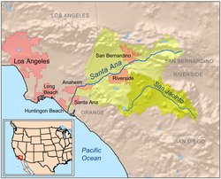
Chino Creek is a major stream of the Inland Empire
in Southern
California
in the United States
. Although the main stem
is short at about 12.7 miles (20.4 km), it drains an extensive basin of 218 mi2 from the San Gabriel Mountains
to the Santa Ana River
near Corona
. The creek's watershed spans three counties, with the majority in San Bernardino County
, and parts of seven incorporated cities.
The drainage basin
is intensely developed for residential, industrial and agricultural use. As a result, the creek and its tributaries are heavily polluted, and receive effluents from multiple wastewater treatment plants and drains. Agricultural pollution from the raising of livestock in the creek's lower basin is the largest source of contamination. There are efforts to control nuisance flows and pollutants in the lower part of the creek to protect the wetlands in the Prado Flood Control Basin, an important ecological area.
, eastern Los Angeles County
. The concretized stream soon enters southwestern San Bernardino County
and runs generally southeast between the Chino Hills
, to the south, and the city of Chino
, to the northeast. One of the creek's main tributaries, San Antonio Creek, comes in from the left about 2 miles (3.2 km) downstream of Pomona. San Antonio Creek, which originates in the San Gabriel Mountains
, drains the northern part of the Chino basin, and is longer than Chino Creek above their confluence.
From there the creek flows roughly parallel to California State Route 71
southeast, through a predominantly industrial and agricultural area. About 6 miles (9.7 km) above the mouth, the streambed changes from a concrete culvert to an earthen channel. The river then enters the El Prado Golf Course and turns south. The last portion of the creek is predominantly marshland, situated within the Prado Flood Control Basin behind the Prado Dam
, and mostly in Riverside County
. The main affluent, Mill Creek, joins from the left within the Basin. Chino Creek then runs south to its confluence with the Santa Ana River just north of the dam about 2.5 miles (4 km) east-northeast of Corona
.
, although most of its tributaries were ephemeral
. The impermeable rock of the Chino Hills, which abut the southwest edge of the watershed, forced groundwater percolating southwards from the San Gabriels to rise to the surface, thus ensuring a stable year round flow even in years of drought.
Historically, the waters of upper San Antonio, Mill and other streams flowing from the mountains disappeared into the ground about 10 to 15 mi (16.1 to 24.1 km) north of Chino Creek, only to reappear within a few miles of the main stream, providing most of its flow. The deposits by the San Gabriel streams are generally hundreds of feet deep and gradually decrease in coarseness in a southerly direction. These tributaries originally joined Chino only during extreme floods. Before channelization, San Antonio Creek was recognized as the upper section of Chino Creek, as the first water in the latter stream rose to the surface at their confluence.
 The drainage basin
of Chino Creek spans 218 mi2 in parts of Los Angeles, San Bernardino and Riverside Counties, with the vast majority within southwestern San Bernardino County. The broad, flat watershed comprises much of the southeastern slopes of the San Gabriel Mountains and alluvial plains
that lie to the south of the range. Almost 55 percent of the basin is heavy urban development, and major cities include Rancho Cucamonga
, Ontario
, Upland
, Pomona and Chino. ~20% of the watershed is wild land, mostly in the mountainous north within the Angeles National Forest
, and the remaining quarter in the south is used for agriculture, much for the raising of livestock
.
The largest tributaries of Chino Creek are San Antonio Creek and Mill Creek (called Cucamonga Creek in San Bernardino County), both of which are longer than the main stem. Other tributaries include Little Chino Creek and an unnamed left fork that drains a large area south of Chino and north of the El Prado Golf Course. To the west the Chino Creek drainage basin borders on the San Gabriel River
watershed, specifically the tributaries of that river, Coyote Creek
, Walnut Creek, San Jose Creek and the East Fork San Gabriel River. To the east lies the basin of Etiwanda Creek, a tributary of the Santa Ana; to the northeast is Lytle Creek
, another Santa Ana tributary stream.
The Chino Creek watershed is notable for containing the heaviest concentration of dairy farms in the United States. A 50 mi2 area of farmland in the southern part of the basin was found to have up to 400,000 cows in a study by the Regional Water Quality Control Board. Waste generated on these farms has led to severely raised nitrate and salinity levels in the creek. The Chino Creek Wetlands conservation area was established at the creek's mouth in 2008 in an effort to filter pollutants in the stream. The preserve comprises 22 acres (8.9 ha) and includes artificial wetlands irrigated with water from the creek.
, alfalfa
and sugar beet
s made up most of the agricultural production. Dams were constructed on Chino Creek and miles of irrigation laterals laid, but due to the stream's low flows and tendency for flash floods the system as a whole was not extremely efficient.
By the 20th century steady urban development of the basin led to increased flooding risk because of urban runoff
problems, and floods were causing more damage to property adjoining streams. In the 1960s upper Chino Creek and most of its tributaries were channelized with concrete to allow faster passage of floodwaters, but this essentially caused the ecological devastation of the creek. Currently the channelized sections of lower Chino Creek have a design capacity of roughly 53000 cuft/s. The San Antonio Dam was constructed in 1956 by the U.S. Army Corps of Engineers to control floods from upper San Antonio Creek.
Inland Empire (California)
The Inland Empire is a region in Southern California. The region sits directly east of the Los Angeles metropolitan area. The Inland Empire most commonly is used in reference to the U.S. Census Bureau's federally-defined Riverside-San Bernardino-Ontario metropolitan area, which covers more than...
in Southern
Southern California
Southern California is a megaregion, or megapolitan area, in the southern area of the U.S. state of California. Large urban areas include Greater Los Angeles and Greater San Diego. The urban area stretches along the coast from Ventura through the Southland and Inland Empire to San Diego...
California
California
California is a state located on the West Coast of the United States. It is by far the most populous U.S. state, and the third-largest by land area...
in the United States
United States
The United States of America is a federal constitutional republic comprising fifty states and a federal district...
. Although the main stem
Main Stem
"Main Stem" is 1942 instrumental by Duke Ellington and His Famous Orchestra. Although recorded in 1942, the single would not be released until 1944 where it was Duke Ellington's last of four number one's on the Harlem Hit Parade. "Main Stem" would also peak at number twenty on the pop chart"Main...
is short at about 12.7 miles (20.4 km), it drains an extensive basin of 218 mi2 from the San Gabriel Mountains
San Gabriel Mountains
The San Gabriel Mountains Range is located in northern Los Angeles County and western San Bernardino County, California, United States. The mountain range lies between the Los Angeles Basin and the Mojave Desert, with Interstate 5 to the west and Interstate 15 to the east...
to the Santa Ana River
Santa Ana River
The Santa Ana River is the largest river of Southern California in the United States. Its drainage basin spans four counties. It rises in the San Bernardino Mountains and flows past the cities of San Bernardino and Riverside, before cutting through the northern tip of the Santa Ana Mountains and...
near Corona
Corona, California
Corona is a city in Riverside County, California, United States. As of the 2010 census, the city had a population of 152,374, up from 124,966 at the 2000 census...
. The creek's watershed spans three counties, with the majority in San Bernardino County
San Bernardino County, California
San Bernardino County is a county in the U.S. state of California. As of the 2010 census, the population was 2,035,210, up from 1,709,434 as of the 2000 census...
, and parts of seven incorporated cities.
The drainage basin
Drainage basin
A drainage basin is an extent or an area of land where surface water from rain and melting snow or ice converges to a single point, usually the exit of the basin, where the waters join another waterbody, such as a river, lake, reservoir, estuary, wetland, sea, or ocean...
is intensely developed for residential, industrial and agricultural use. As a result, the creek and its tributaries are heavily polluted, and receive effluents from multiple wastewater treatment plants and drains. Agricultural pollution from the raising of livestock in the creek's lower basin is the largest source of contamination. There are efforts to control nuisance flows and pollutants in the lower part of the creek to protect the wetlands in the Prado Flood Control Basin, an important ecological area.
Course
It rises as a storm water conduit flowing southwards from a subdivision in southern PomonaPomona, California
-2010:The 2010 United States Census reported that Pomona had a population of 149,058, a slight decline from the 2000 census population. The population density was 6,491.2 people per square mile...
, eastern Los Angeles County
Los Angeles County, California
Los Angeles County is a county in the U.S. state of California. As of 2010 U.S. Census, the county had a population of 9,818,605, making it the most populous county in the United States. Los Angeles County alone is more populous than 42 individual U.S. states...
. The concretized stream soon enters southwestern San Bernardino County
San Bernardino County, California
San Bernardino County is a county in the U.S. state of California. As of the 2010 census, the population was 2,035,210, up from 1,709,434 as of the 2000 census...
and runs generally southeast between the Chino Hills
Chino Hills
The Chino Hills are a mountain range on the border of Orange, Los Angeles, and San Bernardino Counties, California, with a small portion in Riverside County...
, to the south, and the city of Chino
Chino, California
Chino is a city in San Bernardino County, California, United States. It is located in the western end of the Riverside-San Bernardino Area and it is easily accessible via the Chino Valley and Pomona freeways....
, to the northeast. One of the creek's main tributaries, San Antonio Creek, comes in from the left about 2 miles (3.2 km) downstream of Pomona. San Antonio Creek, which originates in the San Gabriel Mountains
San Gabriel Mountains
The San Gabriel Mountains Range is located in northern Los Angeles County and western San Bernardino County, California, United States. The mountain range lies between the Los Angeles Basin and the Mojave Desert, with Interstate 5 to the west and Interstate 15 to the east...
, drains the northern part of the Chino basin, and is longer than Chino Creek above their confluence.
From there the creek flows roughly parallel to California State Route 71
California State Route 71
State Route 71 is the Chino Valley Freeway, formerly the Corona Expressway and before then the Temescal Freeway, a freeway/highway of about 15 miles in length located entirely within Southern California, United States...
southeast, through a predominantly industrial and agricultural area. About 6 miles (9.7 km) above the mouth, the streambed changes from a concrete culvert to an earthen channel. The river then enters the El Prado Golf Course and turns south. The last portion of the creek is predominantly marshland, situated within the Prado Flood Control Basin behind the Prado Dam
Prado Dam
Prado Dam is an earth-fill dam across the Santa Ana River at the Chino Hills near Corona, California in Riverside County with the resulting impounded water creating Prado Flood Control Basin reservoir. The U.S. Army Corps of Engineers built the dam in Lower Santa Ana River Canyon...
, and mostly in Riverside County
Riverside County, California
Riverside County is a county in the U.S. state of California. One of 58 California counties, it covers in the southern part of the state, and stretches from Orange County to the Colorado River, which forms the state border with Arizona. The county derives its name from the city of Riverside,...
. The main affluent, Mill Creek, joins from the left within the Basin. Chino Creek then runs south to its confluence with the Santa Ana River just north of the dam about 2.5 miles (4 km) east-northeast of Corona
Corona, California
Corona is a city in Riverside County, California, United States. As of the 2010 census, the city had a population of 152,374, up from 124,966 at the 2000 census...
.
Geology
The creek runs along the southwest side of the gently sloping alluvial Cucamonga Plain comprising sediments deposited by erosion from the San Gabriel Mountains; it essentially follows the southern outline of the combined alluvial fans of San Antonio, Mill/Cucamonga, Deer, and other tributary streams flowing from the range. Even before urbanization, Chino Creek was a permanent streamPerennial stream
A perennial stream or perennial river is a stream or river that has continuous flow in parts of its bed all year round during years of normal rainfall. "Perennial" streams are contrasted with "intermittent" streams which normally cease flowing for weeks or months each year, and with "ephemeral"...
, although most of its tributaries were ephemeral
Ephemeral
Ephemeral things are transitory, existing only briefly. Typically the term is used to describe objects found in nature, although it can describe a wide range of things....
. The impermeable rock of the Chino Hills, which abut the southwest edge of the watershed, forced groundwater percolating southwards from the San Gabriels to rise to the surface, thus ensuring a stable year round flow even in years of drought.
Historically, the waters of upper San Antonio, Mill and other streams flowing from the mountains disappeared into the ground about 10 to 15 mi (16.1 to 24.1 km) north of Chino Creek, only to reappear within a few miles of the main stream, providing most of its flow. The deposits by the San Gabriel streams are generally hundreds of feet deep and gradually decrease in coarseness in a southerly direction. These tributaries originally joined Chino only during extreme floods. Before channelization, San Antonio Creek was recognized as the upper section of Chino Creek, as the first water in the latter stream rose to the surface at their confluence.
Watershed
Drainage basin
A drainage basin is an extent or an area of land where surface water from rain and melting snow or ice converges to a single point, usually the exit of the basin, where the waters join another waterbody, such as a river, lake, reservoir, estuary, wetland, sea, or ocean...
of Chino Creek spans 218 mi2 in parts of Los Angeles, San Bernardino and Riverside Counties, with the vast majority within southwestern San Bernardino County. The broad, flat watershed comprises much of the southeastern slopes of the San Gabriel Mountains and alluvial plains
Alluvium
Alluvium is loose, unconsolidated soil or sediments, eroded, deposited, and reshaped by water in some form in a non-marine setting. Alluvium is typically made up of a variety of materials, including fine particles of silt and clay and larger particles of sand and gravel...
that lie to the south of the range. Almost 55 percent of the basin is heavy urban development, and major cities include Rancho Cucamonga
Rancho Cucamonga, California
Rancho Cucamonga is a suburban city in San Bernardino County, California. As of the 2010 census, the city had a population of 165,269, up from 127,743 at the 2000 census. L. Dennis Michael was elected as Mayor on November 2, 2010. Jack Lam is the City Manager...
, Ontario
Ontario, California
Ontario is a city located in San Bernardino County, California, United States, 35 miles east of downtown Los Angeles. Located in the western part of the Inland Empire region, it lies just east of the Los Angeles county line and is part of the Greater Los Angeles Area...
, Upland
Upland, California
Upland is a city in San Bernardino County, California, located at an elevation of 1,242 feet . As of the 2010 census, the city had a population of 73,732, up from 68,393 at the 2000 census. It was incorporated on May 15, 1906, after previously being named North Ontario.-History and culture:Upland...
, Pomona and Chino. ~20% of the watershed is wild land, mostly in the mountainous north within the Angeles National Forest
Angeles National Forest
The Angeles National Forest of the U.S. National Forest Service is located in the San Gabriel Mountains of Los Angeles County, southern California. It was established on July 1, 1908, incorporating the first San Bernardino National Forest and parts of the former Santa Barbara and San Gabriel...
, and the remaining quarter in the south is used for agriculture, much for the raising of livestock
Livestock
Livestock refers to one or more domesticated animals raised in an agricultural setting to produce commodities such as food, fiber and labor. The term "livestock" as used in this article does not include poultry or farmed fish; however the inclusion of these, especially poultry, within the meaning...
.
The largest tributaries of Chino Creek are San Antonio Creek and Mill Creek (called Cucamonga Creek in San Bernardino County), both of which are longer than the main stem. Other tributaries include Little Chino Creek and an unnamed left fork that drains a large area south of Chino and north of the El Prado Golf Course. To the west the Chino Creek drainage basin borders on the San Gabriel River
San Gabriel River (California)
The San Gabriel River flows through southern Los Angeles County, California in the United States. Its main stem is about long, while its farthest tributaries extend almost altogether...
watershed, specifically the tributaries of that river, Coyote Creek
Coyote Creek (San Gabriel River)
Coyote Creek is a principal tributary of the San Gabriel River in northwest Orange County, southeast Los Angeles County, and southwest Riverside County in the U.S. state of California. It drains a land area of roughly covering five major cities, including Brea, Buena Park, Fullerton, La Habra, and...
, Walnut Creek, San Jose Creek and the East Fork San Gabriel River. To the east lies the basin of Etiwanda Creek, a tributary of the Santa Ana; to the northeast is Lytle Creek
Lytle Creek
Lytle Creek, California, is an approximately stream in southwestern San Bernardino County near the city of San Bernardino. It is a tributary of the Santa Ana River. The river flows through the eastern San Gabriel Mountains and has three forks, the North, Middle and South forks...
, another Santa Ana tributary stream.
The Chino Creek watershed is notable for containing the heaviest concentration of dairy farms in the United States. A 50 mi2 area of farmland in the southern part of the basin was found to have up to 400,000 cows in a study by the Regional Water Quality Control Board. Waste generated on these farms has led to severely raised nitrate and salinity levels in the creek. The Chino Creek Wetlands conservation area was established at the creek's mouth in 2008 in an effort to filter pollutants in the stream. The preserve comprises 22 acres (8.9 ha) and includes artificial wetlands irrigated with water from the creek.
History and human usage
In the late 1800s, the first settlers arrived in the area and established small towns along the creek's confluence with the Santa Ana including Rincon (later changed to Prado). Agricultural development in the large, flat bowl of land adjoining the land between Chino Creek and the Santa Ana River, known as the Chino Basin, was heavy because of the region's rich soils, smooth topography and abundant water resources. CitrusCitrus
Citrus is a common term and genus of flowering plants in the rue family, Rutaceae. Citrus is believed to have originated in the part of Southeast Asia bordered by Northeastern India, Myanmar and the Yunnan province of China...
, alfalfa
Alfalfa
Alfalfa is a flowering plant in the pea family Fabaceae cultivated as an important forage crop in the US, Canada, Argentina, France, Australia, the Middle East, South Africa, and many other countries. It is known as lucerne in the UK, France, Australia, South Africa and New Zealand, and known as...
and sugar beet
Sugar beet
Sugar beet, a cultivated plant of Beta vulgaris, is a plant whose tuber contains a high concentration of sucrose. It is grown commercially for sugar production. Sugar beets and other B...
s made up most of the agricultural production. Dams were constructed on Chino Creek and miles of irrigation laterals laid, but due to the stream's low flows and tendency for flash floods the system as a whole was not extremely efficient.
By the 20th century steady urban development of the basin led to increased flooding risk because of urban runoff
Urban runoff
Urban runoff is surface runoff of rainwater created by urbanization. This runoff is a major source of water pollution in many parts of the United States and other urban communities worldwide.-Overview:...
problems, and floods were causing more damage to property adjoining streams. In the 1960s upper Chino Creek and most of its tributaries were channelized with concrete to allow faster passage of floodwaters, but this essentially caused the ecological devastation of the creek. Currently the channelized sections of lower Chino Creek have a design capacity of roughly 53000 cuft/s. The San Antonio Dam was constructed in 1956 by the U.S. Army Corps of Engineers to control floods from upper San Antonio Creek.
Crossings
Crossings of the creek are listed going downstream. Tributary entry points are also included to clarify locations.- White Avenue
- Philadelphia Street
- Garey Avenue
- Market Plaza
- Towne Avenue
- Riverside Drive
- San Antonio Creek confluence (left)
- Chino Avenue
 State Route 71California State Route 71State Route 71 is the Chino Valley Freeway, formerly the Corona Expressway and before then the Temescal Freeway, a freeway/highway of about 15 miles in length located entirely within Southern California, United States...
- Grand Avenue
- Pipeline Avenue
- State Route 71
- Ramona Avenue
- Little Chino Creek confluence (right)
- Chino Hills Parkway
- Central Avenue
- Confluence of an unnamed tributary (left)
- Pine Avenue
 State Route 83California State Route 83The segment of Euclid Avenue, Route 83, from Philadelphia Street in Ontario north to 24th Street in Upland was added to the National Register of Historic Places as a historic district in 2005...
/Euclid Avenue- Mill Creek confluence (left)
See also
- Chino Valley, CaliforniaChino Valley, CaliforniaChino Valley is properly considered the cities of Chino, California and Chino Hills, California, and has a combined population of approximately 150,000.-Education:*Chino Valley Unified School District- Major thoroughfares :...
- List of rivers of California
- List of tributaries of the Santa Ana River