
Charlemont, Massachusetts
Encyclopedia
Charlemont is a town
in Franklin County
, Massachusetts
, United States
. The population was 1,358 at the 2000 census. It is part of the Springfield, Massachusetts
Metropolitan Statistical Area
.
. The town was mostly rural, with farming being the main industry until the advent of the railroad, which traveled through town towards the Hoosac Tunnel
. Today the town industry also includes tourism, with a ski area and other tourist areas along the Mohawk Trail
.
In the years preceding the Revolutionary War, as Charlemont's citizens grew increasingly dissatisfied with British
rule, Rev. Jonathan Leavitt
was installed as the minister of Charlemont's Congregational Church. Born in Walpole, New Hampshire
and graduate of Yale College
, Rev. Leavitt arrived in Charlemont in 1767, but his Loyalist
sympathies grated on his congregation.
By 1777 the situation came to a stand-off: Leavitt refused to accept his salary in rapidly-depreciating colonial currency. So the town voted to simply close the church, and it stationed a constable at the door to bar the offending reverend. But Leavitt would not be deterred: He moved his sermons to the schoolhouse, where he held forth until 1785, when he was finally dismissed. He sued for his salary, as well as his loss on the depreciated colonial currency, and was awarded £700.
Leavitt's descendants continued to remain in Charlemont and the surrounding region, and several—including Col. Roger Hooker Leavitt
, who represented Charlemont in the Massachusetts House of Representatives
, and his brother Hart Leavitt
-- became notable operators of stations on the Underground Railroad
, sheltering many escaped slaves on their journeys northward.
 According to the United States Census Bureau
, the town has a total area of 26.4 square miles (68.4 km²), of which, 26.1 square miles (67.6 km²) of it is land and 0.3 square mile (0.776996433 km²) of it (0.99%) is water. Charlemont is located in the western part of the county, with a small portion making up the western county line with Berkshire County
. The town is bordered by Rowe
to the northwest, Heath
to the northeast, Colrain
and Shelburne
to the east, Buckland
to the southeast, Hawley
to the southwest, and Savoy
and Florida
to the west. Charlemont is 18 miles west of Greenfield
, 45 miles north-northwest of Springfield
, and 106 miles west-northwest of Boston.
Charlemont's eastern border is marked by the junction of the North River
and the Deerfield River
, the latter flowing westward through town. The majority of town lands lie north of the river, except for a strip along the entire Hawley town border. The town is surrounded by the eastern Berkshires, with the western part of town being dominated by Todd Mountain and the Mohawk Trail State Forest
. Several other lower peaks dot the land north and town of the river, including Bald Mountain and Westfield Mountain north of the center of town, and, just over the Hawley town line, Mount Peak and Mount Institute
. There are also several brooks through town, with Mill Brook lying near the town center (the site of a covered bridge
).
Much of the length of the Deerfield in town is followed by the Mohawk Trail
, also known as Route 2. Near the center of town, the road also junctions with, and shares a short, 0.6-mile concurrency with Route 8A. Along the southern bank of the river, a stretch of the Guilford Rail System
leads freight trains from Greenfield towards the Hoosac Tunnel
in neighboring Florida, towards New York. The nearest interstate, Interstate 91
, is several miles to the east along Route 2. The town lies at the westernmost point of the "Campus West" line of the Franklin Regional Transit Authority (FRTA) bus line, with scheduled stops at the Academy and at Avery's Store. The nearest regional bus and air service is in Greenfield and North Adams
, the nearest Amtrak
rail service is in Pittsfield
, and the nearest national air service is at Albany International Airport
in New York.
of 2000, there were 1,358 people, 524 households, and 353 families residing in the town. By population, Charlemont ranks eighteenth of the 25 towns in Franklin county, and 314th out of the 351 cities and towns in Massachusetts. The population density
was 52.0 people per square mile (20.1/km²), which ranks fifteenth in the county and 310th in the commonwealth. There were 628 housing units at an average density of 24.1 per square mile (9.3/km²). The racial makeup of the town was 95.07% White, 0.29% African American, 0.66% Native American, 0.74% Asian, 0.07% Pacific Islander, 0.44% from other races
, and 2.72% from two or more races. Hispanic or Latino of any race were 1.99% of the population.
There were 524 households out of which 30.7% had children under the age of 18 living with them, 50.8% were married couples
living together, 12.2% had a female householder with no husband present, and 32.6% were non-families. 25.2% of all households were made up of individuals and 8.0% had someone living alone who was 65 years of age or older. The average household size was 2.52 and the average family size was 2.99.
In the town the population was spread out with 25.1% under the age of 18, 8.0% from 18 to 24, 29.1% from 25 to 44, 26.3% from 45 to 64, and 11.6% who were 65 years of age or older. The median age was 38 years. For every 100 females there were 96.8 males. For every 100 females age 18 and over, there were 94.1 males.
The median income for a household in the town was $46,548, and the median income for a family was $50,962. Males had a median income of $37,500 versus $26,667 for females. The per capita income
for the town was $19,577. About 6.5% of families and 10.4% of the population were below the poverty line, including 10.9% of those under age 18 and 4.2% of those age 65 or over.
 Charlemont employs the open town meeting
form of government, and is led by a board of selectmen
. The town has its own police, fire and public works departments. The town's library, Tyler Memorial Library, is connected to the regional library network. Charlemont lies halfway between hospitals in North Adams (North Adams Regional Hospital) and Greenfield (Franklin Medical Center). Greenfield is also the site of most of the county's public services, courthouses and the county jail.
On the state level, Charlemont is represented in the Massachusetts House of Representatives
as part of the First Berkshire district, which includes the northern portion of Berkshire County as well as several towns in northwest Franklin County. In the Massachusetts Senate
, the town is part of the Berkshire, Hampshire and Franklin district, which includes all of Berkshire County and the western portions of Hampshire and Franklin Counties. The town is patrolled by the Second (Shelburne Falls) Station of Troop "B" of the Massachusetts State Police
.
On the national level, Charlemont is represented in the United States House of Representatives
as part of Massachusetts's 1st congressional district
, and has been represented by John Olver
of Amherst
since June 1991. Massachusetts is currently represented in the United States Senate
by Senators John Kerry
and Scott Brown
.
from pre-kindergarten through sixth grades, and all students in the district attend Mohawk Trail Regional High School
in Buckland
. There is a private academy in town, the Academy at Charlemont
, and other private and religious schools in nearby towns.
The nearest community college, Greenfield Community College
, is located in Greenfield. The nearest state college is Massachusetts College of Liberal Arts
in North Adams, and the nearest state university is the University of Massachusetts Amherst
. The nearest private college is Williams College
in Williamstown, with several others located southeast in the Northampton area.
New England town
The New England town is the basic unit of local government in each of the six New England states. Without a direct counterpart in most other U.S. states, New England towns are conceptually similar to civil townships in other states, but are incorporated, possessing powers like cities in other...
in Franklin County
Franklin County, Massachusetts
-Demographics:As of the census of 2000, there were 71,535 people, 29,466 households, and 18,416 families residing in the county. The population density was 102 people per square mile . There were 31,939 housing units at an average density of 46 per square mile...
, Massachusetts
Massachusetts
The Commonwealth of Massachusetts is a state in the New England region of the northeastern United States of America. It is bordered by Rhode Island and Connecticut to the south, New York to the west, and Vermont and New Hampshire to the north; at its east lies the Atlantic Ocean. As of the 2010...
, United States
United States
The United States of America is a federal constitutional republic comprising fifty states and a federal district...
. The population was 1,358 at the 2000 census. It is part of the Springfield, Massachusetts
Springfield, Massachusetts
Springfield is the most populous city in Western New England, and the seat of Hampden County, Massachusetts, United States. Springfield sits on the eastern bank of the Connecticut River near its confluence with three rivers; the western Westfield River, the eastern Chicopee River, and the eastern...
Metropolitan Statistical Area
Springfield, Massachusetts metropolitan area
The Springfield Metropolitan Area is a region that is socio-economically and culturally tied to the City of Springfield, Massachusetts. The U.S. Office of Management and Budget defines the Springfield metropolitan statistical area as consisting of three counties in Western Massachusetts. As of...
.
History
Charlemont was first settled in 1743, having been set off as Boston Township Number 1 in 1735. The town was along the distant frontier at the time, and was the subject of several raids by Native Americans. The town was incorporated as Charlemont in 1765, most likely named for the town in Northern IrelandCharlemont
Charlemont is a small village in County Armagh, Northern Ireland. It had a population of 150 people in the 2001 Census. It is situated within the Armagh City and District Council area...
. The town was mostly rural, with farming being the main industry until the advent of the railroad, which traveled through town towards the Hoosac Tunnel
Hoosac Tunnel
The Hoosac Tunnel is a 4.75-mile-long railroad tunnel in western Massachusetts which passes through the Hoosac Range, an extension of Vermont's Green Mountains. Work began in 1848 and was finally completed in 1875...
. Today the town industry also includes tourism, with a ski area and other tourist areas along the Mohawk Trail
Mohawk Trail
- External links :* *...
.
In the years preceding the Revolutionary War, as Charlemont's citizens grew increasingly dissatisfied with British
Great Britain
Great Britain or Britain is an island situated to the northwest of Continental Europe. It is the ninth largest island in the world, and the largest European island, as well as the largest of the British Isles...
rule, Rev. Jonathan Leavitt
Jonathan Leavitt (minister)
Rev. Jonathan Leavitt was an early New England Congregational minister, born in Connecticut, and subsequently the pastor of churches in New Hampshire and Massachusetts, both of which dismissed him from his posts. Several of Rev...
was installed as the minister of Charlemont's Congregational Church. Born in Walpole, New Hampshire
Walpole, New Hampshire
Walpole is a town in Cheshire County, New Hampshire, United States. The population was 3,734 at the 2010 census.The town's central settlement, where 605 people resided at the 2010 census, is defined as the Walpole census-designated place , and is east of New Hampshire Route 12...
and graduate of Yale College
Yale College
Yale College was the official name of Yale University from 1718 to 1887. The name now refers to the undergraduate part of the university. Each undergraduate student is assigned to one of 12 residential colleges.-Residential colleges:...
, Rev. Leavitt arrived in Charlemont in 1767, but his Loyalist
Loyalist (American Revolution)
Loyalists were American colonists who remained loyal to the Kingdom of Great Britain during the American Revolutionary War. At the time they were often called Tories, Royalists, or King's Men. They were opposed by the Patriots, those who supported the revolution...
sympathies grated on his congregation.
By 1777 the situation came to a stand-off: Leavitt refused to accept his salary in rapidly-depreciating colonial currency. So the town voted to simply close the church, and it stationed a constable at the door to bar the offending reverend. But Leavitt would not be deterred: He moved his sermons to the schoolhouse, where he held forth until 1785, when he was finally dismissed. He sued for his salary, as well as his loss on the depreciated colonial currency, and was awarded £700.
Leavitt's descendants continued to remain in Charlemont and the surrounding region, and several—including Col. Roger Hooker Leavitt
Roger Hooker Leavitt
Col. Roger Hooker Leavitt was a prominent landowner, early industrialist and Massachusetts politician who with other family members was an ardent abolitionist, using his home in Charlemont, Massachusetts as an Underground Railroad station for slaves escaped from the South...
, who represented Charlemont in the Massachusetts House of Representatives
Massachusetts House of Representatives
The Massachusetts House of Representatives is the lower house of the Massachusetts General Court, the state legislature of the Commonwealth of Massachusetts. It is composed of 160 members elected from single-member electoral districts across the Commonwealth. Representatives serve two-year terms...
, and his brother Hart Leavitt
Hart Leavitt
Hart Leavitt was a Massachusetts merchant, landowner, legislator and prominent abolitionist. Leavitt was the brother of Roger Hooker Leavitt, with whom he operated an Underground Railroad station in Charlemont, Massachusetts, where the two brothers, aided by a third sibling in New York, the...
-- became notable operators of stations on the Underground Railroad
Underground Railroad
The Underground Railroad was an informal network of secret routes and safe houses used by 19th-century black slaves in the United States to escape to free states and Canada with the aid of abolitionists and allies who were sympathetic to their cause. The term is also applied to the abolitionists,...
, sheltering many escaped slaves on their journeys northward.
Geography
United States Census Bureau
The United States Census Bureau is the government agency that is responsible for the United States Census. It also gathers other national demographic and economic data...
, the town has a total area of 26.4 square miles (68.4 km²), of which, 26.1 square miles (67.6 km²) of it is land and 0.3 square mile (0.776996433 km²) of it (0.99%) is water. Charlemont is located in the western part of the county, with a small portion making up the western county line with Berkshire County
Berkshire County, Massachusetts
Berkshire County is a non-governmental county located on the western edge of the U.S. state of Massachusetts. As of the 2010 census, the population was 131,219. Its largest city and traditional county seat is Pittsfield...
. The town is bordered by Rowe
Rowe, Massachusetts
Rowe is a town in Franklin County, Massachusetts, United States. The population was 351 at the 2000 census. It is part of the Springfield, Massachusetts Metropolitan Statistical Area.-History:...
to the northwest, Heath
Heath, Massachusetts
Heath is a town in Franklin County, Massachusetts, United States. The population was 805 at the 2000 census. It is part of the Springfield, Massachusetts Metropolitan Statistical Area.- History :...
to the northeast, Colrain
Colrain, Massachusetts
Colrain is a town in Franklin County, Massachusetts, United States. The population was 1,813 at the 2000 census. It is part of the Springfield, Massachusetts Metropolitan Statistical Area.- History :Colrain was first settled in 1735 as "Boston Township No...
and Shelburne
Shelburne, Massachusetts
Shelburne is a town in Franklin County, Massachusetts, United States. The population was 2,058 at the 2000 census. It is part of the Springfield, Massachusetts Metropolitan Statistical Area.The village of Shelburne Falls is located in the town.- History :...
to the east, Buckland
Buckland, Massachusetts
Buckland is a town in Franklin County, Massachusetts, United States. The population was 1,991 at the 2000 census. The town shares the village of Shelburne Falls with neighboring Shelburne...
to the southeast, Hawley
Hawley, Massachusetts
Hawley is a town in Franklin County, Massachusetts, United States. The population was 337 at the 2010 census. It is part of the Springfield, Massachusetts Metropolitan Statistical Area.- History :...
to the southwest, and Savoy
Savoy, Massachusetts
Savoy is a town in Berkshire County, Massachusetts, United States. It is part of the Pittsfield, Massachusetts Metropolitan Statistical Area. The population was 705 at the 2000 census.- History :...
and Florida
Florida, Massachusetts
Florida is a town in Berkshire County, Massachusetts, United States. It is part of the Pittsfield, Massachusetts Metropolitan Statistical Area. The population was 676 at the 2000 census. It is home to the east portal of the Hoosac Tunnel, as well as Whitcomb Summit , the highest point of the Mohawk...
to the west. Charlemont is 18 miles west of Greenfield
Greenfield, Massachusetts
Greenfield is a city in Franklin County, Massachusetts, United States. The population was 17,456 at the 2010 census. It is the county seat of Franklin County. Greenfield is home to Greenfield Community College, the Pioneer Valley Symphony Orchestra, and the Franklin County Fair...
, 45 miles north-northwest of Springfield
Springfield, Massachusetts
Springfield is the most populous city in Western New England, and the seat of Hampden County, Massachusetts, United States. Springfield sits on the eastern bank of the Connecticut River near its confluence with three rivers; the western Westfield River, the eastern Chicopee River, and the eastern...
, and 106 miles west-northwest of Boston.
Charlemont's eastern border is marked by the junction of the North River
North River (Deerfield River)
The North River is a river in western Massachusetts, the United States.It is formed by the confluence of the West Branch and the East Branch of the North River in the town of Colrain, Massachusetts. The river is a tributary of the Deerfield River, joining it just north of the village of...
and the Deerfield River
Deerfield River
Deerfield River is a river that runs for from southern Vermont through northwestern Massachusetts to the Connecticut River. The Deerfield was historically influential in the settlement of western Franklin County, Massachusetts, and its namesake town...
, the latter flowing westward through town. The majority of town lands lie north of the river, except for a strip along the entire Hawley town border. The town is surrounded by the eastern Berkshires, with the western part of town being dominated by Todd Mountain and the Mohawk Trail State Forest
Mohawk Trail State Forest
Mohawk Trail State Forest is a Massachusetts state forest located in Charlemont. The forest is managed by the Department of Conservation and Recreation.-Description:...
. Several other lower peaks dot the land north and town of the river, including Bald Mountain and Westfield Mountain north of the center of town, and, just over the Hawley town line, Mount Peak and Mount Institute
Mount Institute
Mount Institute, 1,538 ft., is a peak located in Hawley, Massachusetts, just south of the village of Charlemont.-History:Mount Institute was named by Horace Mann when he had an educational institute in Charlemont that overlooked the mountain....
. There are also several brooks through town, with Mill Brook lying near the town center (the site of a covered bridge
Covered bridge
A covered bridge is a bridge with enclosed sides and a roof, often accommodating only a single lane of traffic. Most covered bridges are wooden; some newer ones are concrete or metal with glass sides...
).
Much of the length of the Deerfield in town is followed by the Mohawk Trail
Mohawk Trail
- External links :* *...
, also known as Route 2. Near the center of town, the road also junctions with, and shares a short, 0.6-mile concurrency with Route 8A. Along the southern bank of the river, a stretch of the Guilford Rail System
Pan Am Railways
Pan Am Railways, Inc. , known as Guilford Rail System before March 2006, is a holding company that owns and operates Class II regional railroads covering northern New England from Mattawamkeag, Maine to Rotterdam Junction, New York...
leads freight trains from Greenfield towards the Hoosac Tunnel
Hoosac Tunnel
The Hoosac Tunnel is a 4.75-mile-long railroad tunnel in western Massachusetts which passes through the Hoosac Range, an extension of Vermont's Green Mountains. Work began in 1848 and was finally completed in 1875...
in neighboring Florida, towards New York. The nearest interstate, Interstate 91
Interstate 91
Interstate 91 is an Interstate Highway in the New England region of the United States. It provides the primary north–south thoroughfare in the western part of New England...
, is several miles to the east along Route 2. The town lies at the westernmost point of the "Campus West" line of the Franklin Regional Transit Authority (FRTA) bus line, with scheduled stops at the Academy and at Avery's Store. The nearest regional bus and air service is in Greenfield and North Adams
North Adams, Massachusetts
North Adams is a city in Berkshire County, Massachusetts, United States. It is part of the Pittsfield, Massachusetts Metropolitan Statistical Area. The population was 13,708 as of the 2010 census, making it the least populous city in the state...
, the nearest Amtrak
Amtrak
The National Railroad Passenger Corporation, doing business as Amtrak , is a government-owned corporation that was organized on May 1, 1971, to provide intercity passenger train service in the United States. "Amtrak" is a portmanteau of the words "America" and "track". It is headquartered at Union...
rail service is in Pittsfield
Pittsfield, Massachusetts
Pittsfield is the largest city and the county seat of Berkshire County, Massachusetts, United States. It is the principal city of the Pittsfield, Massachusetts Metropolitan Statistical Area which encompasses all of Berkshire County. Its area code is 413. Its ZIP code is 01201...
, and the nearest national air service is at Albany International Airport
Albany International Airport
Albany International Airport is a public use airport located six nautical miles northwest of the central business district of Albany, in Albany County, New York, United States. It is owned by the Albany County Airport Authority....
in New York.
Demographics
As of the censusCensus
A census is the procedure of systematically acquiring and recording information about the members of a given population. It is a regularly occurring and official count of a particular population. The term is used mostly in connection with national population and housing censuses; other common...
of 2000, there were 1,358 people, 524 households, and 353 families residing in the town. By population, Charlemont ranks eighteenth of the 25 towns in Franklin county, and 314th out of the 351 cities and towns in Massachusetts. The population density
Population density
Population density is a measurement of population per unit area or unit volume. It is frequently applied to living organisms, and particularly to humans...
was 52.0 people per square mile (20.1/km²), which ranks fifteenth in the county and 310th in the commonwealth. There were 628 housing units at an average density of 24.1 per square mile (9.3/km²). The racial makeup of the town was 95.07% White, 0.29% African American, 0.66% Native American, 0.74% Asian, 0.07% Pacific Islander, 0.44% from other races
Race (United States Census)
Race and ethnicity in the United States Census, as defined by the Federal Office of Management and Budget and the United States Census Bureau, are self-identification data items in which residents choose the race or races with which they most closely identify, and indicate whether or not they are...
, and 2.72% from two or more races. Hispanic or Latino of any race were 1.99% of the population.
There were 524 households out of which 30.7% had children under the age of 18 living with them, 50.8% were married couples
Marriage
Marriage is a social union or legal contract between people that creates kinship. It is an institution in which interpersonal relationships, usually intimate and sexual, are acknowledged in a variety of ways, depending on the culture or subculture in which it is found...
living together, 12.2% had a female householder with no husband present, and 32.6% were non-families. 25.2% of all households were made up of individuals and 8.0% had someone living alone who was 65 years of age or older. The average household size was 2.52 and the average family size was 2.99.
In the town the population was spread out with 25.1% under the age of 18, 8.0% from 18 to 24, 29.1% from 25 to 44, 26.3% from 45 to 64, and 11.6% who were 65 years of age or older. The median age was 38 years. For every 100 females there were 96.8 males. For every 100 females age 18 and over, there were 94.1 males.
The median income for a household in the town was $46,548, and the median income for a family was $50,962. Males had a median income of $37,500 versus $26,667 for females. The per capita income
Per capita income
Per capita income or income per person is a measure of mean income within an economic aggregate, such as a country or city. It is calculated by taking a measure of all sources of income in the aggregate and dividing it by the total population...
for the town was $19,577. About 6.5% of families and 10.4% of the population were below the poverty line, including 10.9% of those under age 18 and 4.2% of those age 65 or over.
Government
Open town meeting
An open town meeting is a form of town meeting in which all registered voters of a town may vote . This form of government is typical of smaller municipalities in the New England region of the United States....
form of government, and is led by a board of selectmen
Board of selectmen
The board of selectmen is commonly the executive arm of the government of New England towns in the United States. The board typically consists of three or five members, with or without staggered terms.-History:...
. The town has its own police, fire and public works departments. The town's library, Tyler Memorial Library, is connected to the regional library network. Charlemont lies halfway between hospitals in North Adams (North Adams Regional Hospital) and Greenfield (Franklin Medical Center). Greenfield is also the site of most of the county's public services, courthouses and the county jail.
On the state level, Charlemont is represented in the Massachusetts House of Representatives
Massachusetts House of Representatives
The Massachusetts House of Representatives is the lower house of the Massachusetts General Court, the state legislature of the Commonwealth of Massachusetts. It is composed of 160 members elected from single-member electoral districts across the Commonwealth. Representatives serve two-year terms...
as part of the First Berkshire district, which includes the northern portion of Berkshire County as well as several towns in northwest Franklin County. In the Massachusetts Senate
Massachusetts Senate
The Massachusetts Senate is the upper house of the Massachusetts General Court, the bicameral state legislature of the Commonwealth of Massachusetts. The Senate comprises 40 elected members from 40 single-member senatorial districts in the state...
, the town is part of the Berkshire, Hampshire and Franklin district, which includes all of Berkshire County and the western portions of Hampshire and Franklin Counties. The town is patrolled by the Second (Shelburne Falls) Station of Troop "B" of the Massachusetts State Police
Massachusetts State Police
The Massachusetts State Police is an agency of the Commonwealth of Massachusetts' Executive Office of Public Safety and Security responsible for criminal law enforcement and traffic vehicle regulation across the state...
.
On the national level, Charlemont is represented in the United States House of Representatives
United States House of Representatives
The United States House of Representatives is one of the two Houses of the United States Congress, the bicameral legislature which also includes the Senate.The composition and powers of the House are established in Article One of the Constitution...
as part of Massachusetts's 1st congressional district
Massachusetts's 1st congressional district
Massachusetts's 1st congressional district is in western and central Massachusetts. The largest Massachusetts district in area, it covers about one-third of the state and is more rural than the rest. It has the state's highest point, Mount Greylock...
, and has been represented by John Olver
John Olver
John Walter Olver is the U.S. Representative for , serving since 1991. He is a member of the Democratic Party. Early in his career, he was a chemistry professor and served in both chambers of the Massachusetts General Court....
of Amherst
Amherst, Massachusetts
Amherst is a town in Hampshire County, Massachusetts, United States in the Connecticut River valley. As of the 2010 census, the population was 37,819, making it the largest community in Hampshire County . The town is home to Amherst College, Hampshire College, and the University of Massachusetts...
since June 1991. Massachusetts is currently represented in the United States Senate
United States Senate
The United States Senate is the upper house of the bicameral legislature of the United States, and together with the United States House of Representatives comprises the United States Congress. The composition and powers of the Senate are established in Article One of the U.S. Constitution. Each...
by Senators John Kerry
John Kerry
John Forbes Kerry is the senior United States Senator from Massachusetts, the 10th most senior U.S. Senator and chairman of the Senate Foreign Relations Committee. He was the presidential nominee of the Democratic Party in the 2004 presidential election, but lost to former President George W...
and Scott Brown
Scott Brown
Scott Brown is a United States senator.Scott Brown may also refer to:-Sportsmen:*Scott Brown , American college football coach of Kentucky State...
.
Education
Charlemont and neighboring Hawley make up the Hawlemont Regional School District, a sub-district of the 9-town Mohawk Trail Regional School District, which serves much of western Franklin County. Town students attend the Hawlemont Regional Elementary SchoolHawlemont Regional Elementary School
Hawlemont Regional Elementary School is a public elementary school located in Charlemont, Massachusetts, United States. The school's name is a portmanteau derived from the two towns it serves, Hawley and Charlemont...
from pre-kindergarten through sixth grades, and all students in the district attend Mohawk Trail Regional High School
Mohawk Trail Regional High School
Mohawk Trail Regional High School is located on Route 112 in Buckland, Massachusetts, United States. The public school currently serves nine towns, grades 7-12.- History :...
in Buckland
Buckland, Massachusetts
Buckland is a town in Franklin County, Massachusetts, United States. The population was 1,991 at the 2000 census. The town shares the village of Shelburne Falls with neighboring Shelburne...
. There is a private academy in town, the Academy at Charlemont
Academy at Charlemont
The Academy at Charlemont is a small, private, college-preparatory day school, located on the Deerfield River in Charlemont, Massachusetts, that serves grade 7 through postgraduate. It has approximately 110 students. The school was founded by Eric Grinnell, Dianne Grinnell, David W. McKay, Patricia...
, and other private and religious schools in nearby towns.
The nearest community college, Greenfield Community College
Greenfield Community College
Greenfield Community College is a two-year Community College in Greenfield, Massachusetts. It was founded in 1962, currently has an annual enrollment of 3,000, is regionally known for its art program, its small-town atmosphere, and its setting amid picturesque old farmland at the foot of...
, is located in Greenfield. The nearest state college is Massachusetts College of Liberal Arts
Massachusetts College of Liberal Arts
The Massachusetts College of Liberal Arts is a public, residential, liberal arts college that offers both undergraduate and graduate programs. Located in North Adams, Massachusetts, it is part of the state university system of Massachusetts. It is a member of the Council of Public Liberal Arts...
in North Adams, and the nearest state university is the University of Massachusetts Amherst
University of Massachusetts Amherst
The University of Massachusetts Amherst is a public research and land-grant university in Amherst, Massachusetts, United States and the flagship of the University of Massachusetts system...
. The nearest private college is Williams College
Williams College
Williams College is a private liberal arts college located in Williamstown, Massachusetts, United States. It was established in 1793 with funds from the estate of Ephraim Williams. Originally a men's college, Williams became co-educational in 1970. Fraternities were also phased out during this...
in Williamstown, with several others located southeast in the Northampton area.
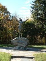
Points of interest
- Alpine Skiing: Charlemont is well known for its alpine ski area, Berkshire East Ski AreaBerkshire East Ski AreaBerkshire East Ski Resort is a medium sized alpine ski area located on Mount Institute in Charlemont and Hawley, Massachusetts.-Thunder Mountain Ski Area:...
. Other ski areas once located in Charlemont include Sawmill Hill, the Mohawk Trail Skiers Project, and Snow White. Berkshire East is open from late fall until early spring and features snowmaking and night skiing.
- Camping: Country Aire Campground/RV Park is located on Route 2 in Charlemont, on the Mohawk Trail. Country Aire Campground
- Hiking: There are multiple popular mountain hikes in Charlemont, accessible via official and unofficial trails, such as Mount InstituteMount InstituteMount Institute, 1,538 ft., is a peak located in Hawley, Massachusetts, just south of the village of Charlemont.-History:Mount Institute was named by Horace Mann when he had an educational institute in Charlemont that overlooked the mountain....
, Negus Mountain, Pocumtuck MountainPocumtuck MountainPocumtuck Mountain, a mountain peak west of the abandoned Catamount settlement, is technically located in Charlemont, Massachusetts. Its summit ledge features wide views of western Franklin County and northern Berkshire County...
, and Todd Mountain.
- Water Rafting: White water rafting is very popular in Charlemont. Zoar Outdoor, Crabapple Whitewater, and Moxie Outdoor Adventures are three popular whitewater rafting operations on the Deerfield River. The scenic Mohawk TrailMohawk Trail- External links :* *...
passes through the community.