

Springfield, Massachusetts metropolitan area
Encyclopedia

Springfield, Massachusetts
Springfield is the most populous city in Western New England, and the seat of Hampden County, Massachusetts, United States. Springfield sits on the eastern bank of the Connecticut River near its confluence with three rivers; the western Westfield River, the eastern Chicopee River, and the eastern...
. The U.S. Office of Management and Budget defines the Springfield metropolitan statistical area (MSA) as consisting of three counties in Western Massachusetts
Western Massachusetts
Western Massachusetts is a loosely defined geographical region of the U.S. state of Massachusetts which contains the Berkshires, the Pioneer Valley, and some or all of the Swift River Valley. The region is always considered to include Berkshire, Franklin, Hampshire, and Hampden counties, and the...
. As of July 1, 2009, the metropolitan area's population was estimated at 698,903. As of the U.S. 2010 Census, the Springfield, Massachusetts metropolitan region is the world's most populous and densely populated "Greater Springfield" region. Following the 2010 Census, there have been discussions about combining the metropolitan area
Metropolitan area
The term metropolitan area refers to a region consisting of a densely populated urban core and its less-populated surrounding territories, sharing industry, infrastructure, and housing. A metropolitan area usually encompasses multiple jurisdictions and municipalities: neighborhoods, townships,...
s of Springfield, Massachusetts
Springfield, Massachusetts
Springfield is the most populous city in Western New England, and the seat of Hampden County, Massachusetts, United States. Springfield sits on the eastern bank of the Connecticut River near its confluence with three rivers; the western Westfield River, the eastern Chicopee River, and the eastern...
and Hartford, Connecticut
Hartford, Connecticut
Hartford is the capital of the U.S. state of Connecticut. The seat of Hartford County until Connecticut disbanded county government in 1960, it is the second most populous city on New England's largest river, the Connecticut River. As of the 2010 Census, Hartford's population was 124,775, making...
, due to the region's economic interdependence and close geographic proximity (23.9 miles separate both cities' downtowns.)
An alternative system of measuring New England
New England
New England is a region in the northeastern corner of the United States consisting of the six states of Maine, New Hampshire, Vermont, Massachusetts, Rhode Island, and Connecticut...
metropolitan areas has developed - called the NECTA - because in New England, major cities and surrounding towns are often much smaller in land area than in other parts of the United States, (e.g. the City of Springfield is 33.2 sq. miles whereas, for example, the City of Fort Worth, Texas is 774.1 sq. miles, nearly 25 times larger in land area than Springfield. Despite the huge discrepancy in land area, New England cities like Springfield generally feature much higher population densities.) Additionally, New England cities and towns have developed allegiances that transcend state borders - thus, cities in Connecticut are included in Springfield's NECTA. This system is thought to better approximate New England's metropolitan areas because it uses New England's geographically smaller building blocks. In Springfield's case, its NECTA consists of 48 additional cities/and towns surrounding the city.
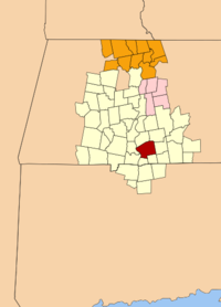
Component counties of the MSA
- HampdenHampden County, Massachusetts-Demographics:As of the census of 2004, there were 461,228 people, 175,288 households, and 115,690 families residing in the county. The population density was 738 people per square mile . There were 185,876 housing units at an average density of 301 per square mile...
- HampshireHampshire County, Massachusetts-Demographics:As of the census of 2000, there were 152,251 people, 55,991 households, and 33,818 families residing in the county. The population density was 288 people per square mile . There were 58,644 housing units at an average density of 111 per square mile...
- FranklinFranklin County, Massachusetts-Demographics:As of the census of 2000, there were 71,535 people, 29,466 households, and 18,416 families residing in the county. The population density was 102 people per square mile . There were 31,939 housing units at an average density of 46 per square mile...
Component cities/towns of the NECTA
|
Granville, Massachusetts Granville is a town in Hampden County, Massachusetts, United States. The population was 1,566 at the 2010 census. It is part of the Springfield, Massachusetts Metropolitan Statistical Area.- History and Description :... Greenfield, Massachusetts Greenfield is a city in Franklin County, Massachusetts, United States. The population was 17,456 at the 2010 census. It is the county seat of Franklin County. Greenfield is home to Greenfield Community College, the Pioneer Valley Symphony Orchestra, and the Franklin County Fair... Hadley, Massachusetts Hadley is a town in Hampshire County, Massachusetts. The population was 4,793 at the 2000 census. It is part of the Springfield, Massachusetts Metropolitan Statistical Area. The area around Hampshire Mall and Mountain Farms Mall along Route 9 is a major shopping destination for the surrounding... Hampden, Massachusetts -Transportation:Hampden is one of sixteen towns in Massachusetts that has no numbered highways or state routes. Of these, half are on the islands, and one is the North Shore town of Nahant. Of the rest, Hampden is the easternmost town to have this distinction. In fact, the town does not even have... Hatfield, Massachusetts Hatfield is a town in Hampshire County, Massachusetts, United States. The population was 3,249 at the 2000 census. It is part of the Springfield, Massachusetts Metropolitan Statistical Area.... Holyoke, Massachusetts Holyoke is a city in Hampden County, Massachusetts, United States, between the western bank of the Connecticut River and the Mount Tom Range of mountains. As of the 2010 Census, the city had a population of 39,880... Huntington, Massachusetts Huntington is a town in Hampshire County, Massachusetts, United States. The population was 2,174 at the 2000 census. It is part of the Springfield, Massachusetts Metropolitan Statistical Area.- History :... Longmeadow, Massachusetts As of the census of 2000, there were 15,633 people, 5,734 households, and 4,432 families residing in the town. The population density was . There were 5,879 housing units at an average density of . The racial makeup of the town was 95.42% White, 0.69% African American, 0.05% Native American, 2.90%... Ludlow, Massachusetts Ludlow is a town in Hampden County, Massachusetts, United States. The population was 21,103 as of the 2010 census. It is located in western Massachusetts, north of Springfield, east of Chicopee, southeast of Granby, southwest of Belchertown, west of Wilbraham and is considered part of the... Middlefield, Massachusetts Middlefield is a town in Hampshire County, Massachusetts, United States. The population was 542 at the 2000 census. It is part of the Springfield, Massachusetts Metropolitan Statistical Area.-Geography:... Monson, Massachusetts Monson is a town in Hampden County, Massachusetts, United States. The population was 8,560 at the 2010 census. It is part of the Springfield, Massachusetts Metropolitan Statistical Area.The village of Monson Center lies at the center of the town.... Montgomery, Massachusetts Montgomery is a town in Hampden County, Massachusetts, United States. The population was 838 at the 2010 census. It is part of the Springfield, Massachusetts Metropolitan Statistical Area.-History:... Northampton, Massachusetts The city of Northampton is the county seat of Hampshire County, Massachusetts, United States. As of the 2010 census, the population of Northampton's central neighborhoods, was 28,549... Palmer, Massachusetts The Town of Palmer is a city in Hampden County, Massachusetts, United States. The population was 12,140 as of the 2000 census. It is part of the Springfield, Massachusetts Metropolitan Statistical Area... Plainfield, Massachusetts Plainfield is a town on the northwestern edge of Hampshire County, Massachusetts, United States, about 25 miles east of Pittsfield and 30 miles northwest of Northampton. The population was 589 at the 2000 census... Russell, Massachusetts Russell is a town in Hampden County, Massachusetts, United States. The population was 1,775 at the 2010 census. It is part of the Springfield, Massachusetts Metropolitan Statistical Area.-Geography:... |
Somers, Connecticut Somers is a town in Tolland County, Connecticut, USA. The population was 10,417 at the 2000 census. The town center is listed by the U.S. Census Bureau as a census-designated place... South Hadley, Massachusetts South Hadley is a town in Hampshire County, Massachusetts, United States. The population was 17,514 at the 2010 census. It is part of the Springfield, Massachusetts Metropolitan Statistical Area.... Southampton, Massachusetts Southampton is a town in Hampshire County, Massachusetts, United States. It was established first as a district of Northampton in 1753. It was incorporated in 1753. The name Southampton was given to it during its first town meeting in 1773. Its ZIP code is 01073... Southwick, Massachusetts Southwick is a town in Hampden County, Massachusetts, United States. The population was 9,502 at the 2010 census. It is part of the Springfield, Massachusetts Metropolitan Statistical Area.- History :... Springfield, Massachusetts Springfield is the most populous city in Western New England, and the seat of Hampden County, Massachusetts, United States. Springfield sits on the eastern bank of the Connecticut River near its confluence with three rivers; the western Westfield River, the eastern Chicopee River, and the eastern... (Principal city) Suffield, Connecticut Suffield is a town in Hartford County, Connecticut, United States. It had once been within the boundaries of Massachusetts. The town is located in the Connecticut River Valley with the town of Enfield neighboring to the east. In 1900, 3,521 people lived in Suffield; and in 1910, 3,841. As of the... Tolland, Massachusetts Tolland is a town in Hampden County, Massachusetts, United States. The population was 485 at the 2010 census, making it the smallest town in Hampden County by population. It is part of the Springfield, Massachusetts Metropolitan Statistical Area. Tolland formerly had a popular "Black Fly Day"... Wales, Massachusetts Wales is a town in Hampden County, Massachusetts, United States. The population was 1,838 at the 2010 census. It is part of the Springfield, Massachusetts Metropolitan Statistical Area.- History :... Ware, Massachusetts Ware is a town in Hampshire County, Massachusetts, United States. The population was 9,707 at the 2000 census. It is part of the Springfield, Massachusetts Metropolitan Statistical Area.Part of the town comprises the census-designated place of Ware.... West Springfield, Massachusetts The Town of West Springfield is a city in Hampden County, Massachusetts, United States. It is part of the Springfield, Massachusetts Metropolitan Statistical Area. The population was 28,391 at the 2010 census... Westfield, Massachusetts Westfield is a city in Hampden County, in the Pioneer Valley of western Massachusetts, United States. It is part of the Springfield, Massachusetts Metropolitan Statistical Area. The population was 41,094 at the 2010 census. The ZIP Code is 01085 for homes and businesses, 01086 for Westfield State... Westhampton, Massachusetts Westhampton is a town in Hampshire County, Massachusetts, United States. The population was 1,607 at the 2010 census. It is part of the Springfield, Massachusetts Metropolitan Statistical Area.- History :... Whately, Massachusetts Whately is a town in Franklin County, Massachusetts, United States. The population was 1,573 at the 2000 census. It is part of the Springfield, Massachusetts Metropolitan Statistical Area.- History :... Wilbraham, Massachusetts Wilbraham is a town in Hampden County, Massachusetts, United States. It is also a suburb of the City of Springfield, Massachusetts and part of the Springfield Metropolitan Statistical Area. The population was 14,868 at the 2010 census... Williamsburg, Massachusetts Williamsburg is a town in Hampshire County, Massachusetts, United States. The population was 2,482 at the 2010 census. It is part of the Springfield, Massachusetts Metropolitan Statistical Area.-The Mill River Flood:... Windsor Locks, Connecticut Windsor Locks is a town located in Hartford County, Connecticut, United States. As of the 2000 census, its population was 12,043. It is the site of Bradley International Airport, which serves the Greater Hartford-Springfield region. It is also the site of the New England Air Museum... Worthington, Massachusetts Worthington is a town in Hampshire County, Massachusetts, United States. The population was 1,270 at the 2000 census. It is part of the Springfield, Massachusetts Metropolitan Statistical Area.-Geography:... |
Demographics
As of the censusCensus
A census is the procedure of systematically acquiring and recording information about the members of a given population. It is a regularly occurring and official count of a particular population. The term is used mostly in connection with national population and housing censuses; other common...
of 2000, there were 680,014 people, 260,745 households, and 167,924 families residing within the MSA. The racial makeup of the MSA was 83.50% White, 5.96% African American, 0.25% Native American, 1.74% Asian, 0.06% Pacific Islander, 6.35% from other races
Race (United States Census)
Race and ethnicity in the United States Census, as defined by the Federal Office of Management and Budget and the United States Census Bureau, are self-identification data items in which residents choose the race or races with which they most closely identify, and indicate whether or not they are...
, and 2.13% from two or more races. Hispanic or Latino of any race were 11.15% of the population.
The median income for a household in the MSA was $42,195, and the median income for a family was $52,551. Males had a median income of $37,784 versus $28,404 for females. The per capita income
Per capita income
Per capita income or income per person is a measure of mean income within an economic aggregate, such as a country or city. It is calculated by taking a measure of all sources of income in the aggregate and dividing it by the total population...
for the MSA was $20,633.
Transportation
The Pioneer Valley Transit AuthorityPioneer Valley Transit Authority
The Pioneer Valley Transit Authority oversees and coordinates public transportation in the Pioneer Valley of Western Massachusetts. Currently the PVTA offers fixed-route bus service as well as paratransit service for the elderly and disabled. The PVTA was created by Chapter 161B of the...
(PVTA) is the primary operator of public transportation services in the Springfield Metropolitan Area. Headquartered in Springfield, the PVTA maintains a fleet of approximately 174 buses, 144 vans, and "is the largest regional transit authority in Massachusetts." Founded in 1974 with the enactment of Massachusetts General Law Chapter 161B, the PVTA serves 24 member communities in Hampden
Hampden County, Massachusetts
-Demographics:As of the census of 2004, there were 461,228 people, 175,288 households, and 115,690 families residing in the county. The population density was 738 people per square mile . There were 185,876 housing units at an average density of 301 per square mile...
, Hampshire
Hampshire County, Massachusetts
-Demographics:As of the census of 2000, there were 152,251 people, 55,991 households, and 33,818 families residing in the county. The population density was 288 people per square mile . There were 58,644 housing units at an average density of 111 per square mile...
, and Franklin
Franklin County, Massachusetts
-Demographics:As of the census of 2000, there were 71,535 people, 29,466 households, and 18,416 families residing in the county. The population density was 102 people per square mile . There were 31,939 housing units at an average density of 46 per square mile...
counties. Each member community pays an assessment fee to the PVTA based "on the number of miles served in that city or town." Alternative sources of revenue mostly originate from federal
Federal government of the United States
The federal government of the United States is the national government of the constitutional republic of fifty states that is the United States of America. The federal government comprises three distinct branches of government: a legislative, an executive and a judiciary. These branches and...
and state
Government of Massachusetts
The form of Massachusetts government is provided by the Constitution of the Commonwealth. The legislative power is exercised by the bicameral General Court, which is composed of the Senate and House of Representatives...
government
Government
Government refers to the legislators, administrators, and arbitrators in the administrative bureaucracy who control a state at a given time, and to the system of government by which they are organized...
s. The PVTA itself is governed by an advisory board
Advisory board
An advisory board is a body that advises the board of directors and management of a corporation but does not have authority to vote on corporate matters, nor a legal fiduciary responsibility...
.