
Shelburne, Massachusetts
Encyclopedia
Shelburne is a town
in Franklin County
, Massachusetts
, United States
. The population was 2,058 at the 2000 census. It is part of the Springfield, Massachusetts
Metropolitan Statistical Area
.
The village of Shelburne Falls
is located in the town.
known then as "Deerfield Northwest." It was initially organized as the district of Shelburne in 1768 (named in honor of William Petty, 2nd Earl of Shelburne
) and was officially incorporated as a town in 1775. Shelburne's character has always been two-sided; the main body of town has farmland among the low hills, while the area around Shelburne Falls has mostly been a milling community.
 According to the United States Census Bureau
, the town has a total area of 23.5 square miles (60.9 km²), of which, 23.2 square miles (60.1 km²) of it is land and 0.2 square mile (0.517997622 km²) of it (0.85%) is water. Shelburne is located in central Franklin County, and is bordered by Colrain
to the north, Greenfield
to the east, Deerfield
to the southeast, Conway
to the south, Buckland
to the west, and a short, 0.4 mile (0.643736 km) stretch of Charlemont
to the northwest. The town's center is located five miles (8 km) from Greenfield, 39 miles (62.8 km) north of Springfield
, and 95 miles (152.9 km) west-northwest of Boston.
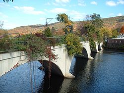
Shelburne lies along the eastern banks of the Deerfield River
, which flows along the town's southern and western border. Several brooks feed into the river through the town, flowing down from several low peaks of the foothills of The Berkshires
. Massaemett Mountain
is the highest point in town, lying just east of Shelburne Falls, and there are several other low peaks, including Greenfield Mountain to the east. Massaemett also is home to two small sections of the town's state forest. In the village of Shelburne Falls are the "Glacial Potholes," a waterfall with many "potholes," traces of large rock activity along the Deerfield River.
Shelburne lies along Route 2, commonly known as the Mohawk Trail
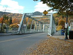
, which is the main east-west route through the northern part of Massachusetts. The short, westernmost section of Route 2A connects the trail into the heart of Shelburne Falls, passing into Buckland before finally ending there. Shelburne Falls is also served by Route 112, which follows the river southward before crossing with Route 2A across the 1890 truss bridge
into Buckland, where the road bends northward before eventually continuing southward. The nearest interstate, Interstate 91
, passes through neighboring Greenfield and Deerfield, and can be accessed along Route 2.
The nearest freight rail service is in Buckland, with the nearest Amtrak
service being in Pittsfield
or Springfield. There is regional bus service in Greenfield, as well as the Campus West route of the Franklin Regional Transit Authority (FRTA), which extends towards Charlemont with a scheduled stop in Shelburne Falls. The nearest general aviation airport is in nearby Turners Falls
, with the nearest national air service being at Bradley International Airport
in Windsor Locks, Connecticut
.
 As of the census
of 2000, there were 2,058 people, 834 households, and 517 families residing in the town. By population, Shelburne ranked eighth out of the 26 towns in Franklin County, and 290th out of the 351 cities and towns in Massachusetts. The population density
was 88.5 people per square mile (34.2/km²), which ranked tenth in the county and 291st in the Commonwealth. There were 886 housing units at an average density of 38.1 per square mile (14.7/km²). The racial makeup of the town was 97.28% White, 0.49% African American, 0.44% Native American, 0.24% Asian, 0.05% Pacific Islander, 0.39% from other races
, and 1.12% from two or more races. Hispanic or Latino of any race were 0.58% of the population.
There were 834 households out of which 27.6% had children under the age of 18 living with them, 50.2% were married couples
living together, 7.4% had a female householder with no husband present, and 37.9% were non-families. 30.3% of all households were made up of individuals and 13.8% had someone living alone who was 65 years of age or older. The average household size was 2.31 and the average family size was 2.86.
In the town the population was spread out with 21.1% under the age of 18, 6.2% from 18 to 24, 23.0% from 25 to 44, 29.3% from 45 to 64, and 20.5% who were 65 years of age or older. The median age was 45 years. For every 100 females there were 89.9 males. For every 100 females age 18 and over, there were 84.9 males.
The median income for a household in the town was $42,054, and the median income for a family was $51,364. Males had a median income of $39,018 versus $28,550 for females. The per capita income
for the town was $20,329. About 8.7% of families and 9.9% of the population were below the poverty line, including 6.6% of those under age 18 and 17.5% of those age 65 or over.
 Shelburne employs the open town meeting
form of government, and is led by a board of selectmen
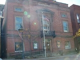
. All of the town offices, except for the Shelburne Volunteer Fire Department, are located within the area of Shelburne Falls, including the police department (which shares the town hall), a post office (which also serves the Buckland side of Shelburne Falls), and the Arms Library, which is connected to the regional library networks. The town's main cemetery, Arms Cemetery, is also located near Shelburne Falls. The nearest hospital, Franklin Medical Center, is located in Greenfield, as are most of the nearest state offices.
On the state level, Shelburne is represented in the Massachusetts House of Representatives
as part of the Second Berkshire district, represented by Paul Mark, which covers central Berkshire County, as well as portions of Hampshire and Franklin Counties. In the Massachusetts Senate
, the town is part of the Hampshire and Franklin district, represented by Stan Rosenberg, which includes most of eastern Franklin County and much of eastern Hampshire County. The town is home to the Second Barracks of Troop "B" of the Massachusetts State Police
.
On the national level, Shelburne is represented in the United States House of Representatives
as part of Massachusetts's 1st congressional district
, and has been represented by John Olver
of Amherst
since June 1991. Massachusetts is represented in the United States Senate
by senior Senator John Kerry
and junior Senator Scott Brown.
in Buckland
. There are several private, religious and charter schools located in the Greenfield area, with the most prominent being Deerfield Academy
in Deerfield
, Northfield Mount Hermon School in Gill
and the Academy at Charlemont
in Charlemont
.
The nearest community college, Greenfield Community College
, is located in Greenfield. The nearest state college is Massachusetts College of Liberal Arts
in North Adams, and the nearest state university is the University of Massachusetts Amherst
. The nearest private colleges, including members of the Five Colleges
and Seven Sisters
, are located southeast in the Northampton area.
New England town
The New England town is the basic unit of local government in each of the six New England states. Without a direct counterpart in most other U.S. states, New England towns are conceptually similar to civil townships in other states, but are incorporated, possessing powers like cities in other...
in Franklin County
Franklin County, Massachusetts
-Demographics:As of the census of 2000, there were 71,535 people, 29,466 households, and 18,416 families residing in the county. The population density was 102 people per square mile . There were 31,939 housing units at an average density of 46 per square mile...
, Massachusetts
Massachusetts
The Commonwealth of Massachusetts is a state in the New England region of the northeastern United States of America. It is bordered by Rhode Island and Connecticut to the south, New York to the west, and Vermont and New Hampshire to the north; at its east lies the Atlantic Ocean. As of the 2010...
, United States
United States
The United States of America is a federal constitutional republic comprising fifty states and a federal district...
. The population was 2,058 at the 2000 census. It is part of the Springfield, Massachusetts
Springfield, Massachusetts
Springfield is the most populous city in Western New England, and the seat of Hampden County, Massachusetts, United States. Springfield sits on the eastern bank of the Connecticut River near its confluence with three rivers; the western Westfield River, the eastern Chicopee River, and the eastern...
Metropolitan Statistical Area
Springfield, Massachusetts metropolitan area
The Springfield Metropolitan Area is a region that is socio-economically and culturally tied to the City of Springfield, Massachusetts. The U.S. Office of Management and Budget defines the Springfield metropolitan statistical area as consisting of three counties in Western Massachusetts. As of...
.
The village of Shelburne Falls
Shelburne Falls, Massachusetts
Shelburne Falls is a census-designated place in the towns of Shelburne and Buckland in Franklin County, Massachusetts, United States. The population was 1,951 at the 2000 census. It is part of the Springfield, Massachusetts, Metropolitan Statistical Area...
is located in the town.
History
Shelburne was first settled in 1756 as part of Deerfield, MassachusettsDeerfield, Massachusetts
Deerfield is a town in Franklin County, Massachusetts, United States. The population was 4,750 as of the 2000 census. Deerfield is part of the Springfield, Massachusetts Metropolitan Statistical Area in Western Massachusetts, lying only north of the city of Springfield.Deerfield includes the...
known then as "Deerfield Northwest." It was initially organized as the district of Shelburne in 1768 (named in honor of William Petty, 2nd Earl of Shelburne
William Petty, 2nd Earl of Shelburne
William Petty-FitzMaurice, 1st Marquess of Lansdowne, KG, PC , known as The Earl of Shelburne between 1761 and 1784, by which title he is generally known to history, was an Irish-born British Whig statesman who was the first Home Secretary in 1782 and then Prime Minister 1782–1783 during the final...
) and was officially incorporated as a town in 1775. Shelburne's character has always been two-sided; the main body of town has farmland among the low hills, while the area around Shelburne Falls has mostly been a milling community.
Geography
United States Census Bureau
The United States Census Bureau is the government agency that is responsible for the United States Census. It also gathers other national demographic and economic data...
, the town has a total area of 23.5 square miles (60.9 km²), of which, 23.2 square miles (60.1 km²) of it is land and 0.2 square mile (0.517997622 km²) of it (0.85%) is water. Shelburne is located in central Franklin County, and is bordered by Colrain
Colrain, Massachusetts
Colrain is a town in Franklin County, Massachusetts, United States. The population was 1,813 at the 2000 census. It is part of the Springfield, Massachusetts Metropolitan Statistical Area.- History :Colrain was first settled in 1735 as "Boston Township No...
to the north, Greenfield
Greenfield, Massachusetts
Greenfield is a city in Franklin County, Massachusetts, United States. The population was 17,456 at the 2010 census. It is the county seat of Franklin County. Greenfield is home to Greenfield Community College, the Pioneer Valley Symphony Orchestra, and the Franklin County Fair...
to the east, Deerfield
Deerfield, Massachusetts
Deerfield is a town in Franklin County, Massachusetts, United States. The population was 4,750 as of the 2000 census. Deerfield is part of the Springfield, Massachusetts Metropolitan Statistical Area in Western Massachusetts, lying only north of the city of Springfield.Deerfield includes the...
to the southeast, Conway
Conway, Massachusetts
Conway is a town in Franklin County, Massachusetts, United States. The population was 1,809 at the 2000 census. It is part of the Springfield, Massachusetts Metropolitan Statistical Area.- History :...
to the south, Buckland
Buckland, Massachusetts
Buckland is a town in Franklin County, Massachusetts, United States. The population was 1,991 at the 2000 census. The town shares the village of Shelburne Falls with neighboring Shelburne...
to the west, and a short, 0.4 mile (0.643736 km) stretch of Charlemont
Charlemont, Massachusetts
Charlemont is a town in Franklin County, Massachusetts, United States. The population was 1,358 at the 2000 census. It is part of the Springfield, Massachusetts Metropolitan Statistical Area.- History :...
to the northwest. The town's center is located five miles (8 km) from Greenfield, 39 miles (62.8 km) north of Springfield
Springfield, Massachusetts
Springfield is the most populous city in Western New England, and the seat of Hampden County, Massachusetts, United States. Springfield sits on the eastern bank of the Connecticut River near its confluence with three rivers; the western Westfield River, the eastern Chicopee River, and the eastern...
, and 95 miles (152.9 km) west-northwest of Boston.
Shelburne lies along the eastern banks of the Deerfield River
Deerfield River
Deerfield River is a river that runs for from southern Vermont through northwestern Massachusetts to the Connecticut River. The Deerfield was historically influential in the settlement of western Franklin County, Massachusetts, and its namesake town...
, which flows along the town's southern and western border. Several brooks feed into the river through the town, flowing down from several low peaks of the foothills of The Berkshires
The Berkshires
The Berkshires , is a highland geologic region located in the western parts of Massachusetts and Connecticut.Also referred to as the Berkshire Hills, Berkshire Mountains, and Berkshire Plateau, the region enjoys a vibrant tourism industry based on music, arts, and recreation.-Definition:The term...
. Massaemett Mountain
Massaemett Mountain
Massaemett Mountain is a mountain in Shelburne, Massachusetts, USA. It is located east of the village of Shelburne Falls.The summit features a historic rock fire tower...
is the highest point in town, lying just east of Shelburne Falls, and there are several other low peaks, including Greenfield Mountain to the east. Massaemett also is home to two small sections of the town's state forest. In the village of Shelburne Falls are the "Glacial Potholes," a waterfall with many "potholes," traces of large rock activity along the Deerfield River.
Shelburne lies along Route 2, commonly known as the Mohawk Trail
Mohawk Trail
- External links :* *...
, which is the main east-west route through the northern part of Massachusetts. The short, westernmost section of Route 2A connects the trail into the heart of Shelburne Falls, passing into Buckland before finally ending there. Shelburne Falls is also served by Route 112, which follows the river southward before crossing with Route 2A across the 1890 truss bridge
Truss bridge
A truss bridge is a bridge composed of connected elements which may be stressed from tension, compression, or sometimes both in response to dynamic loads. Truss bridges are one of the oldest types of modern bridges...
into Buckland, where the road bends northward before eventually continuing southward. The nearest interstate, Interstate 91
Interstate 91
Interstate 91 is an Interstate Highway in the New England region of the United States. It provides the primary north–south thoroughfare in the western part of New England...
, passes through neighboring Greenfield and Deerfield, and can be accessed along Route 2.
The nearest freight rail service is in Buckland, with the nearest Amtrak
Amtrak
The National Railroad Passenger Corporation, doing business as Amtrak , is a government-owned corporation that was organized on May 1, 1971, to provide intercity passenger train service in the United States. "Amtrak" is a portmanteau of the words "America" and "track". It is headquartered at Union...
service being in Pittsfield
Pittsfield, Massachusetts
Pittsfield is the largest city and the county seat of Berkshire County, Massachusetts, United States. It is the principal city of the Pittsfield, Massachusetts Metropolitan Statistical Area which encompasses all of Berkshire County. Its area code is 413. Its ZIP code is 01201...
or Springfield. There is regional bus service in Greenfield, as well as the Campus West route of the Franklin Regional Transit Authority (FRTA), which extends towards Charlemont with a scheduled stop in Shelburne Falls. The nearest general aviation airport is in nearby Turners Falls
Montague, Massachusetts
Montague is a town in Franklin County, Massachusetts, United States. The population was 8,489 at the 2000 census. It is part of the Springfield, Massachusetts metropolitan statistical area....
, with the nearest national air service being at Bradley International Airport
Bradley International Airport
Bradley International Airport is a joint civil-military public airport located in Windsor Locks on the border with East Granby and Suffield, in Hartford County, Connecticut, United States. It is owned by the State of Connecticut....
in Windsor Locks, Connecticut
Windsor Locks, Connecticut
Windsor Locks is a town located in Hartford County, Connecticut, United States. As of the 2000 census, its population was 12,043. It is the site of Bradley International Airport, which serves the Greater Hartford-Springfield region. It is also the site of the New England Air Museum...
.
Demographics
Census
A census is the procedure of systematically acquiring and recording information about the members of a given population. It is a regularly occurring and official count of a particular population. The term is used mostly in connection with national population and housing censuses; other common...
of 2000, there were 2,058 people, 834 households, and 517 families residing in the town. By population, Shelburne ranked eighth out of the 26 towns in Franklin County, and 290th out of the 351 cities and towns in Massachusetts. The population density
Population density
Population density is a measurement of population per unit area or unit volume. It is frequently applied to living organisms, and particularly to humans...
was 88.5 people per square mile (34.2/km²), which ranked tenth in the county and 291st in the Commonwealth. There were 886 housing units at an average density of 38.1 per square mile (14.7/km²). The racial makeup of the town was 97.28% White, 0.49% African American, 0.44% Native American, 0.24% Asian, 0.05% Pacific Islander, 0.39% from other races
Race (United States Census)
Race and ethnicity in the United States Census, as defined by the Federal Office of Management and Budget and the United States Census Bureau, are self-identification data items in which residents choose the race or races with which they most closely identify, and indicate whether or not they are...
, and 1.12% from two or more races. Hispanic or Latino of any race were 0.58% of the population.
There were 834 households out of which 27.6% had children under the age of 18 living with them, 50.2% were married couples
Marriage
Marriage is a social union or legal contract between people that creates kinship. It is an institution in which interpersonal relationships, usually intimate and sexual, are acknowledged in a variety of ways, depending on the culture or subculture in which it is found...
living together, 7.4% had a female householder with no husband present, and 37.9% were non-families. 30.3% of all households were made up of individuals and 13.8% had someone living alone who was 65 years of age or older. The average household size was 2.31 and the average family size was 2.86.
In the town the population was spread out with 21.1% under the age of 18, 6.2% from 18 to 24, 23.0% from 25 to 44, 29.3% from 45 to 64, and 20.5% who were 65 years of age or older. The median age was 45 years. For every 100 females there were 89.9 males. For every 100 females age 18 and over, there were 84.9 males.
The median income for a household in the town was $42,054, and the median income for a family was $51,364. Males had a median income of $39,018 versus $28,550 for females. The per capita income
Per capita income
Per capita income or income per person is a measure of mean income within an economic aggregate, such as a country or city. It is calculated by taking a measure of all sources of income in the aggregate and dividing it by the total population...
for the town was $20,329. About 8.7% of families and 9.9% of the population were below the poverty line, including 6.6% of those under age 18 and 17.5% of those age 65 or over.
Government
Open town meeting
An open town meeting is a form of town meeting in which all registered voters of a town may vote . This form of government is typical of smaller municipalities in the New England region of the United States....
form of government, and is led by a board of selectmen
Board of selectmen
The board of selectmen is commonly the executive arm of the government of New England towns in the United States. The board typically consists of three or five members, with or without staggered terms.-History:...
. All of the town offices, except for the Shelburne Volunteer Fire Department, are located within the area of Shelburne Falls, including the police department (which shares the town hall), a post office (which also serves the Buckland side of Shelburne Falls), and the Arms Library, which is connected to the regional library networks. The town's main cemetery, Arms Cemetery, is also located near Shelburne Falls. The nearest hospital, Franklin Medical Center, is located in Greenfield, as are most of the nearest state offices.
On the state level, Shelburne is represented in the Massachusetts House of Representatives
Massachusetts House of Representatives
The Massachusetts House of Representatives is the lower house of the Massachusetts General Court, the state legislature of the Commonwealth of Massachusetts. It is composed of 160 members elected from single-member electoral districts across the Commonwealth. Representatives serve two-year terms...
as part of the Second Berkshire district, represented by Paul Mark, which covers central Berkshire County, as well as portions of Hampshire and Franklin Counties. In the Massachusetts Senate
Massachusetts Senate
The Massachusetts Senate is the upper house of the Massachusetts General Court, the bicameral state legislature of the Commonwealth of Massachusetts. The Senate comprises 40 elected members from 40 single-member senatorial districts in the state...
, the town is part of the Hampshire and Franklin district, represented by Stan Rosenberg, which includes most of eastern Franklin County and much of eastern Hampshire County. The town is home to the Second Barracks of Troop "B" of the Massachusetts State Police
Massachusetts State Police
The Massachusetts State Police is an agency of the Commonwealth of Massachusetts' Executive Office of Public Safety and Security responsible for criminal law enforcement and traffic vehicle regulation across the state...
.
On the national level, Shelburne is represented in the United States House of Representatives
United States House of Representatives
The United States House of Representatives is one of the two Houses of the United States Congress, the bicameral legislature which also includes the Senate.The composition and powers of the House are established in Article One of the Constitution...
as part of Massachusetts's 1st congressional district
Massachusetts's 1st congressional district
Massachusetts's 1st congressional district is in western and central Massachusetts. The largest Massachusetts district in area, it covers about one-third of the state and is more rural than the rest. It has the state's highest point, Mount Greylock...
, and has been represented by John Olver
John Olver
John Walter Olver is the U.S. Representative for , serving since 1991. He is a member of the Democratic Party. Early in his career, he was a chemistry professor and served in both chambers of the Massachusetts General Court....
of Amherst
Amherst, Massachusetts
Amherst is a town in Hampshire County, Massachusetts, United States in the Connecticut River valley. As of the 2010 census, the population was 37,819, making it the largest community in Hampshire County . The town is home to Amherst College, Hampshire College, and the University of Massachusetts...
since June 1991. Massachusetts is represented in the United States Senate
United States Senate
The United States Senate is the upper house of the bicameral legislature of the United States, and together with the United States House of Representatives comprises the United States Congress. The composition and powers of the Senate are established in Article One of the U.S. Constitution. Each...
by senior Senator John Kerry
John Kerry
John Forbes Kerry is the senior United States Senator from Massachusetts, the 10th most senior U.S. Senator and chairman of the Senate Foreign Relations Committee. He was the presidential nominee of the Democratic Party in the 2004 presidential election, but lost to former President George W...
and junior Senator Scott Brown.
Education
Shelburne is a member of the Mohawk Trail Regional School District, which covers six towns on the elementary level and most of western Franklin County on the upper levels of education. Buckland-Shelburne Regional Elementary School serves students from pre-kindergarten through sixth grades for the two towns, and students from grades 7-12 attend Mohawk Trail Regional High SchoolMohawk Trail Regional High School
Mohawk Trail Regional High School is located on Route 112 in Buckland, Massachusetts, United States. The public school currently serves nine towns, grades 7-12.- History :...
in Buckland
Buckland, Massachusetts
Buckland is a town in Franklin County, Massachusetts, United States. The population was 1,991 at the 2000 census. The town shares the village of Shelburne Falls with neighboring Shelburne...
. There are several private, religious and charter schools located in the Greenfield area, with the most prominent being Deerfield Academy
Deerfield Academy
Deerfield Academy is an independent, coeducational boarding school in Deerfield, Massachusetts, United States. It is a four-year college-preparatory school with approximately 600 students and about 100 faculty, all of whom live on or near campus....
in Deerfield
Deerfield, Massachusetts
Deerfield is a town in Franklin County, Massachusetts, United States. The population was 4,750 as of the 2000 census. Deerfield is part of the Springfield, Massachusetts Metropolitan Statistical Area in Western Massachusetts, lying only north of the city of Springfield.Deerfield includes the...
, Northfield Mount Hermon School in Gill
Gill, Massachusetts
Gill is a town in Franklin County, Massachusetts, USA. The population was 1,363 at the 2000 census. It is part of the Springfield, Massachusetts Metropolitan Statistical Area...
and the Academy at Charlemont
Academy at Charlemont
The Academy at Charlemont is a small, private, college-preparatory day school, located on the Deerfield River in Charlemont, Massachusetts, that serves grade 7 through postgraduate. It has approximately 110 students. The school was founded by Eric Grinnell, Dianne Grinnell, David W. McKay, Patricia...
in Charlemont
Charlemont, Massachusetts
Charlemont is a town in Franklin County, Massachusetts, United States. The population was 1,358 at the 2000 census. It is part of the Springfield, Massachusetts Metropolitan Statistical Area.- History :...
.
The nearest community college, Greenfield Community College
Greenfield Community College
Greenfield Community College is a two-year Community College in Greenfield, Massachusetts. It was founded in 1962, currently has an annual enrollment of 3,000, is regionally known for its art program, its small-town atmosphere, and its setting amid picturesque old farmland at the foot of...
, is located in Greenfield. The nearest state college is Massachusetts College of Liberal Arts
Massachusetts College of Liberal Arts
The Massachusetts College of Liberal Arts is a public, residential, liberal arts college that offers both undergraduate and graduate programs. Located in North Adams, Massachusetts, it is part of the state university system of Massachusetts. It is a member of the Council of Public Liberal Arts...
in North Adams, and the nearest state university is the University of Massachusetts Amherst
University of Massachusetts Amherst
The University of Massachusetts Amherst is a public research and land-grant university in Amherst, Massachusetts, United States and the flagship of the University of Massachusetts system...
. The nearest private colleges, including members of the Five Colleges
Five Colleges (Massachusetts)
The Five Colleges comprises four liberal arts colleges and one university in the Connecticut River Pioneer Valley of Western Massachusetts, totaling approximately 28,000 students. The schools belong to a consortium called Five Colleges, Incorporated, established in 1965...
and Seven Sisters
Seven Sisters (colleges)
The Seven Sisters are seven liberal arts colleges in the Northeastern United States that are historically women's colleges. They are Barnard College, Bryn Mawr College, Mount Holyoke College, Radcliffe College, Smith College, Vassar College, and Wellesley College. All were founded between 1837 and...
, are located southeast in the Northampton area.