
.gif)
Chaitén (volcano)
Encyclopedia
Caldera
A caldera is a cauldron-like volcanic feature usually formed by the collapse of land following a volcanic eruption, such as the one at Yellowstone National Park in the US. They are sometimes confused with volcanic craters...
3 kilometres (2 mi) in diameter, 17 kilometres (10.6 mi) west of the elongated ice-capped Michinmahuida
Michinmahuida
Michinmahuida is a glaciated stratovolcano located in Los Lagos Region of Chile. It lies about 15 km east of Chaitén volcano, and was extensively covered in ash during the 2008 eruption of Chaitén...
volcano and 10 kilometres (6 mi) northeast of the town of Chaitén
Chaitén
Chaitén is a Chilean town, commune and former capital of the Palena Province in Los Lagos Region. The town is located north of the mouth of Yelcho River, on the east coast of the Gulf of Corcovado...
, near the Gulf of Corcovado
Gulf of Corcovado
Gulf of Corcovado is a large body of water separating the Chiloé Island from the mainland of Chile. Geologically it is a foreland basin that has been carved out by Quaternary glaciers. A large population of blue whales is found there, and it is under threat from salmon farming....
in southern Chile
Chile
Chile ,officially the Republic of Chile , is a country in South America occupying a long, narrow coastal strip between the Andes mountains to the east and the Pacific Ocean to the west. It borders Peru to the north, Bolivia to the northeast, Argentina to the east, and the Drake Passage in the far...
. The most recent eruptive phase of the volcano began on 2 May 2008, and is ongoing. According to the Global Volcanism Program
Global Volcanism Program
The Smithsonian Institution's Global Volcanism Program documents Earth's volcanoes and their eruptive history over the past 10,000 years. The GVP reports on current eruptions from around the world as well as maintaining a database repository on active volcanoes and their eruptions. In this way, a...
, radiocarbon dating
Radiocarbon dating
Radiocarbon dating is a radiometric dating method that uses the naturally occurring radioisotope carbon-14 to estimate the age of carbon-bearing materials up to about 58,000 to 62,000 years. Raw, i.e. uncalibrated, radiocarbon ages are usually reported in radiocarbon years "Before Present" ,...
of older tephra
Tephra
200px|thumb|right|Tephra horizons in south-central [[Iceland]]. The thick and light coloured layer at center of the photo is [[rhyolitic]] tephra from [[Hekla]]....
from the volcano suggests that its last previous eruption was in 7420 BC ± 75 years.
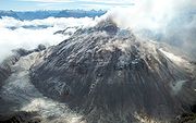
The caldera rim reaches 1122 metres (3,681 ft) above sea level. Before the current eruption, it was mostly filled by a rhyolite
Rhyolite
This page is about a volcanic rock. For the ghost town see Rhyolite, Nevada, and for the satellite system, see Rhyolite/Aquacade.Rhyolite is an igneous, volcanic rock, of felsic composition . It may have any texture from glassy to aphanitic to porphyritic...
obsidian
Obsidian
Obsidian is a naturally occurring volcanic glass formed as an extrusive igneous rock.It is produced when felsic lava extruded from a volcano cools rapidly with minimum crystal growth...
lava dome
Lava dome
|250px|thumb|right|Image of the [[rhyolitic]] lava dome of [[Chaitén Volcano]] during its 2008–2009 eruption.In volcanology, a lava dome is a roughly circular mound-shaped protrusion resulting from the slow extrusion of viscous lava from a volcano...
that reached a height of 962 metres (3,156 ft), partly devoid of vegetation. Two small lakes occupied the caldera floor on the west and north sides of the lava dome.
The translucent grey obsidian
Obsidian
Obsidian is a naturally occurring volcanic glass formed as an extrusive igneous rock.It is produced when felsic lava extruded from a volcano cools rapidly with minimum crystal growth...
which had erupted from the volcano was used by pre-Columbian
Pre-Columbian
The pre-Columbian era incorporates all period subdivisions in the history and prehistory of the Americas before the appearance of significant European influences on the American continents, spanning the time of the original settlement in the Upper Paleolithic period to European colonization during...
cultures as a raw material for artifacts and has been found as far away as 400 kilometres (248.5 mi) to the south and north, for example in Chan-Chan
Chan-Chan
thumb|right|300px|View of the beach of Chan-Chan and the forested Tren-Tren peninsula south of the main archaeological site.Chan-Chan is an archaeological site and beach on the coast of the commune of Mehuín in southern Chile. Chan-Chan is known to have been inhabited by hunter-gatherers during...
.
2008-09 eruption
Chilean government began an evacuation of the nearby town of ChaiténChaitén
Chaitén is a Chilean town, commune and former capital of the Palena Province in Los Lagos Region. The town is located north of the mouth of Yelcho River, on the east coast of the Gulf of Corcovado...
(population 4,200) and the surrounding area the same day, the main phase of which was completed by May 3, 2008. One elderly person died while at sea en route for Puerto Montt
Puerto Montt
Puerto Montt is a port city and commune in southern Chile, located at the northern end of the Reloncaví Sound in the Llanquihue Province, Los Lagos Region. The commune spans an area of and had a population of 175,938 in 2002. It is located 1,055 km to the south of the capital, Santiago...
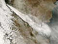
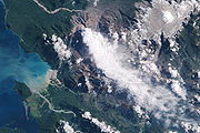
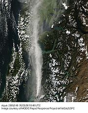
. By the afternoon of May 3, the plume of ash
Volcanic ash
Volcanic ash consists of small tephra, which are bits of pulverized rock and glass created by volcanic eruptions, less than in diameter. There are three mechanisms of volcanic ash formation: gas release under decompression causing magmatic eruptions; thermal contraction from chilling on contact...
from the eruption had spread across Chile and Argentina
Argentina
Argentina , officially the Argentine Republic , is the second largest country in South America by land area, after Brazil. It is constituted as a federation of 23 provinces and an autonomous city, Buenos Aires...
to the Atlantic Ocean
Atlantic Ocean
The Atlantic Ocean is the second-largest of the world's oceanic divisions. With a total area of about , it covers approximately 20% of the Earth's surface and about 26% of its water surface area...
, contaminating water supplies, and reportedly coating the town of Futaleufú
Futaleufú, Chile
Futaleufú is a Chilean town and commune located in Palena Province, Los Lagos Region. The commune is named after Futaleufú River. Due to the eruption of Chaitén Volcano and the subsequent destruction of Chaitén, Futaleufú has been the capital of Palena Province since March 2009. The town is close...
located 75 kilometres (46.6 mi) southeast to a depth of 30 centimetres (11.8 in). Ash thickness estimates are often exaggerated during volcanic crises; later field investigations suggest that the average ash thickness deposited across Futaleufú was less than 5–10 cm (2–4 in).
The initial phase of the actual eruption in 2008 was characterised by ash emissions and seismic activity; local seismic measurements in 2005 registered earthquakes up to magnitude 3.6 MW below the Chaitén volcano. On May 6, 2008 the force of eruption increased significantly, producing pyroclastic flow
Pyroclastic flow
A pyroclastic flow is a fast-moving current of superheated gas and rock , which reaches speeds moving away from a volcano of up to 700 km/h . The flows normally hug the ground and travel downhill, or spread laterally under gravity...
s and possibly some lava
Lava
Lava refers both to molten rock expelled by a volcano during an eruption and the resulting rock after solidification and cooling. This molten rock is formed in the interior of some planets, including Earth, and some of their satellites. When first erupted from a volcanic vent, lava is a liquid at...
explosions, and raising the eruption column
Eruption column
An eruption column consists of hot volcanic ash emitted during an explosive volcanic eruption. The ash forms a column rising many kilometres into the air above the peak of the volcano. In the most explosive eruptions, the eruption column may rise over 40 km, penetrating the stratosphere...
to a height of perhaps 30000 metres (98,425.2 ft). The remaining personnel and almost all inhabitants of Chaitén and nearby villages were evacuated, as was Futaleufú.
In the early phase of the eruption (May 2, 2008), two separate vents had developed in the old lava dome. An overflight on 6 May 2008 found that these had fused into one vent roughly 800 metres (2,624.7 ft) across. OVDAS warned of possible major pyroclastic incidents, and the likelihood of prolonged activity.
On May 8, 2008 the government said it would force the last residents from the danger area, but this was later legally challenged by some residents and left to no effect by the Supreme Court
Supreme Court of Chile
The Supreme Court of Chile is the highest court in Chile. It also administrates the lower courts in the nation. It is located in the capital Santiago....
. Government personnel later returned to attend to livestock and rescue dogs and other animals.
Through the remainder of May and June 2008 the eruption continued as a variable but gradually decreasing emission of ash, with intermittent seismic activity and pyroclastic flows. On 21 May 2008, a new lava dome was observed to be forming in the crater, which by 24 May 2008 exceeded the height of the old dome. Initially, the dome extended towards the north side of the caldera, but following the emergence of two new vents in the south of the old dome around June 11 and a later one to the west, the expansion moved to the south, eventually blocking the drainage from the caldera floor.
In August 2008, an expedition reached the summit of Chaiten volcano. The summit crater contained a 120 metres (393.7 ft) high lava dome. Earthquakes were felt at the summit. The lava dome was loudly degassing, and lava boulders avalanched from the dome side to the crater floor.
On February 19, 2009, a partial dome collapse caused pyroclastic flows to descend through the Chaitén river valley reaching down to approximately 5 kilometres (3 mi) from the town of Chaitén. The ash once again reached Futaleufú and parts of Chubut
Chubut Province
Chubut a province in the southern part of Argentina situated between the 42nd parallel south and the 46th parallel south , the Andes range separating Argentina from Chile, and the Atlantic ocean...
province in neighboring Argentina
Argentina
Argentina , officially the Argentine Republic , is the second largest country in South America by land area, after Brazil. It is constituted as a federation of 23 provinces and an autonomous city, Buenos Aires...
. The approximately 160 people that were in Chaitén were strongly urged to leave, and all but 25 people who refused to leave were evacuated that day.
Damage
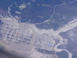
Forests near the volcano have been burned by pyroclastic flows and lateral explosions. Large parts of southern Argentina and Chile have been coated with ash, with possible longer term consequences for agriculture, although not only negative as ash adds new minerals to the soil. Large amounts of ash have fallen in some areas, posing a risk of lahars for several communities.Beginning on May 12, lahars caused flooding in the town of Chaitén, depositing ash mud to a depth of up to a metre or more, damaging many buildings, and completely filling the original course of the Chaitén River past the town. Over the subsequent weeks, the river excavated a new course through Chaitén, completely destroying a significant part of it by July 2008. Some defensive work has been undertaken by the government, and the town will be reconstructed some 10 kilometres (6 mi) north.
Rarity
This eruption is known as the first major explosive eruption of rhyolite magma in nearly a century, since the 1912 eruption of NovaruptaNovarupta
Novarupta, meaning "new eruption", is a volcano located on the Alaska Peninsula in Katmai National Park and Preserve, about southwest of Anchorage. Formed in 1912 during the largest volcanic eruption of the 20th century, Novarupta released 30 times the volume of magma as the 1980 eruption of...
, in Alaska
Alaska
Alaska is the largest state in the United States by area. It is situated in the northwest extremity of the North American continent, with Canada to the east, the Arctic Ocean to the north, and the Pacific Ocean to the west and south, with Russia further west across the Bering Strait...
. Although there have been rhyolitic eruptions in the southern section of the Southern Volcanic Zone in the past, these are relatively scarce and there is no historic rhyolitic eruption of the magnitude of Chaitén.
External links
Articles- BBC News: In pictures: Chile volcano erupts
- Chaiten Volcano Still Active - The Big Picture - Boston.com
- Dagbladet: Vulkanen blir sintere
- SERNAGEOMIN
- TerraDaily: Chilean volcano turns Chaiten into ghost town
- The Volcanism Blog - Chaitén
- Chaiten Volcano - John Seach
Scientific Papers on the Chaitén eruption
- A Folch et al., 2008, Volcanic ash forecast – application to the May 2008 Chaitén eruption, Nat. Hazards Earth Syst. Sci., 8, 927-940
- LE Lara, 2009, The 2008 eruption of the Chaitén volcano: a preliminary report, Andean Geology 36, 125-129
- SFL Watt et al., 2009, Fallout and distribution of volcanic ash over Argentina following the May 2008 explosive eruption of Chaiten, Chile, Journal of Geophysical Research (Solid Earth) 114, B04207
- M Reich et al., 2009, Formation of cristobalite nanofibers during explosive volcanic eruptions, Geology 37, 435-438
Photography
- BBC, November 1, 2008, Alert at smoking Chile volcano
- Images and videos of current eruption
- Region de los Lagos regional government photographs of the emergency.
- Image gallery
Webcams
- Chaitén caldera webcam (Southern Andean Volcano ObservatorySouthern Andean Volcano Observatory200px|thumb|right|[[Llaima]]'s 2008 eruption as viewed from [[Temuco]]The Southern Andean Volcano Observatory , also known by its acronyms as OVDAS, is a program of the Chilean National Geology and Mining Service to watch the most dangerous volcanoes of the Southern Volcanic Zone in Zona Sur and...
) - Chaitén Airport (SCTN) webcams, "Cámara Norte" looks directly towards Chaitén Volcano