
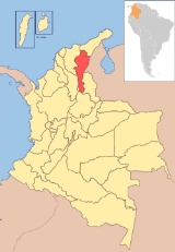
Cesar Department
Encyclopedia
Cesar Department or simply Cesar is a department
of Colombia
located in the north of the country in the Caribbean region, bordering to the north with the Department of La Guajira
, to the west with the Department of Magdalena and Department of Bolivar, to the south with Department of Santander, to the west with the Department of North Santander
, and to the east with the country of Venezuela
(Zulia State). The department capital city is Valledupar
.
The region was first inhabited by indigenous peoples known as Euparíes in the Valley of Upar and Guatapuríes in the Valley of the Cesar river, among these were the Orejones pertaining to the Tupe, Acanayutos pertaining to the Motilones and Alcoholados pertaining to the Chimilas. The first European to explore the area was Spanish Captain Pedro de Vadillo, but German Ambrosio Alfínger savagely conquered the region in 1532. In 1550 the village of Valle de Upar was founded by Hernando de Santana
and Juan de Castellanos
.
In 1813, María de la Concepción Loperena proclaimed the independence in Valledupar and donated 300 horses to Simon Bolivar
. In 1829 Valledupar became a cantón of the province of Santa Marta. By Law 15 of 1850, Valledupar was segregated from Santa Marta becoming the province of Valledupar. In 1857 became a province of the state of Magdalena and by Law of December 29, 1864 became the department of Valledupar pertaining to state of Magdalena. On December 27, 1967 the department of Cesar was created officially.
, in reference to the Cesar River
. The valley that its basin covers is also named after the river and extends through most of the department. The department of Cesar was created in 1967 by decree and the name officially adopted.
 The department of Cesar is located in northern Colombia bordering to the north with the department of La Guajira
, to the east with the Bolivarian Republic of Venezuela, to the west with the department of Magdalena, to the southwest with the Department of Bolivar and to the south with the departments of North Santander
and Santander covering a total area of 22,905 km².
The majority of the Department is flat in 57% of the total area and 43% mountainous mainly in the Serrania del Perija and the Sierra Nevada de Santa Marta mountain ranges.
s; the Serrania del Perija
mountain range, the valley of the Cesar River
, the Sierra Nevada de Santa Marta
mountain range, the valley of the Magdalena River
and the Cienaga de Zapatosa
marsh
es complex.

mountain range covers most of the eastern side of the Department of Cesar between its border with Venezuela and the Department of North Santander
, approximately 300 km in length penetrating into the Department of La Guajira
to the north and covering 27% of the total area of Cesar. The Serrania del Perija covers, partially or totally the area of 17 municipalities in the Department of Cesar; Aguachica, Codazzi, Becerril, Chimichagua, Chiriguana, Curumani, Gonzalez, La Gloria, La Jagua de Ibirico, Los Robles La Paz, Manaure, Pailitas, Pelaya, Rio de Oro, San Alberto, San Diego and San Martin. There are also the indigenous reserves pertaining to the Yukpa
s people; Iroka, Socorpa and Menkue-Misaya-La Pista; and to the Wiwas people; Caño Padilla, El Rosario-Bella Vista-Yucatán and Campoalegre.
Approximately 70% of the mountain range preserves unique flora and fauna and some 20 rivers are born in the mountain range among other minor streams, flowing into the Department of Cesar and feeding the Magdalena and Cesar river basins and the Cienaga de Zapatosa marshes. The Colombian government declared it a National Forest Reserve.
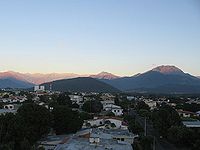 The Sierra Nevada de Santa Marta mountain range is an isolated mountain range located in the northwestern region of the Department of Cesar. The mountain range is shared with by Department of La Guajira, which covers the northern area, the Department of Magdalena to the western side and the Department of Cesar which covers the southern face, covering a total area of 16,615 km² (1'661,500 ha) of which 380,000 ha pertain to the Department of Cesar. The Cesar River and the western side of its basin is born on the Sierra Nevada de Santa Marta, including the Guatapuri
, Badillo, Ariguani
, Cesarito, Los Clavos, Garupal and Rio Seco rivers. The mountains are within the boundaries of the municipalities of Pueblo Bello, Valledupar, El Copey and Bosconia.
The Sierra Nevada de Santa Marta was declared by UNESCO
as a Biosphere Reserve on October 29, 1993.
Spanish chronicles describe the tribes as being part of a federation of tribes led by Caciques, with the village of Eupari as the largest and central to the other villages. These tribes are believed to be related to the Mesoamerica
n culture, the Caribs and Arawaks, directly associated to the Muisca
culture in the Colombian eastern branch of the Andes
.
Archeological findings has shown that the indigenous in the area worked with stones and wood, including a boomerang
shaped weapon found in a cemetery at Los Robles La Paz
.
and Juan de Castellanos
.
. In 1829 Valledupar became a Cantón of the Province of Santa Marta. By Law 15 of 1850, Valledupar was segregated frim Santa Marta becoming the Province of Valledupar. In 1857 became a province of the State of Magdalena and by Law of December 29, 1864 became the Department of Valledupar pertaining to State of Magdalena. On December 27, 1967 the Department of Cesar was created officially.
 The economy of the César Department is sustained by the agricultural sector, secondly by a services industry following with commercial industry
and mining
. Cattle raising is exploited extensively (using large farms), and for this reason large portions of forest
s have been chopped off to create corral
s. In agriculture
, plantations of cotton
, rice
, sugar cane, oil palm
, cassava
and plantain
. Services are centered on commerce and the industry is represented by oil products
, fat
s and milk
derived products. As one of the biggest water resources
areas of Colombia
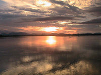
, if not America, part of the Magdalena River
crosses the Department and helps create the Cienaga de Zapatosa
(Zapatosa Marsh
) along with the Cesar river. It has a great potential to develop a fishing industry
also, but it is practiced at a minimum. Most of the territory has not been explored in the search of more minerals due to violence, but because of recent findings, it became a potential source.http://www.banrep.gov.co/docum/Pdf-econom-region/Documentos/DTSER-59.pdf
Departments of Colombia
Colombia is an unitary republic formed by thirty-two departments and a Capital District . Each department has a Governor and a Department Assembly , elected by popular vote for a four-year period. The governor cannot be re-elected in consecutive periods...
of Colombia
Colombia
Colombia, officially the Republic of Colombia , is a unitary constitutional republic comprising thirty-two departments. The country is located in northwestern South America, bordered to the east by Venezuela and Brazil; to the south by Ecuador and Peru; to the north by the Caribbean Sea; to the...
located in the north of the country in the Caribbean region, bordering to the north with the Department of La Guajira
Department of La Guajira
La Guajira is a department of Colombia. It occupies most of its namesake peninsula, the Guajira Peninsula in the northeast region of the country, facing the Caribbean Sea and Venezuela in the northern most part of South America...
, to the west with the Department of Magdalena and Department of Bolivar, to the south with Department of Santander, to the west with the Department of North Santander
Department of North Santander
North Santander is a department of Colombia. It is in the north of the country, bordering Venezuela. Its capital is Cúcuta, one of the major cities of Colombia....
, and to the east with the country of Venezuela
Venezuela
Venezuela , officially called the Bolivarian Republic of Venezuela , is a tropical country on the northern coast of South America. It borders Colombia to the west, Guyana to the east, and Brazil to the south...
(Zulia State). The department capital city is Valledupar
Valledupar
Valledupar is a city and municipality in northeastern Colombia. It is the capital of Cesar Department and was founded in 1550 by the Spanish conquistador Hernando de Santana. Its name, Valle de Upar , was established in honor of the Amerindian cacique who ruled the valley; Cacique Upar...
.
The region was first inhabited by indigenous peoples known as Euparíes in the Valley of Upar and Guatapuríes in the Valley of the Cesar river, among these were the Orejones pertaining to the Tupe, Acanayutos pertaining to the Motilones and Alcoholados pertaining to the Chimilas. The first European to explore the area was Spanish Captain Pedro de Vadillo, but German Ambrosio Alfínger savagely conquered the region in 1532. In 1550 the village of Valle de Upar was founded by Hernando de Santana
Hernando de Santana
Hernando de Santana was a Spanish conqueror, the founder of the City of Valledupar and conqueror in what is now northern Colombia....
and Juan de Castellanos
Juan de Castellanos
Juan de Castellanos was a Criollo poet, soldier and Catholic priest.He travelled to America before 1545 as a cavalry soldier, and acquired some property on the Pearl Coast...
.
In 1813, María de la Concepción Loperena proclaimed the independence in Valledupar and donated 300 horses to Simon Bolivar
Simón Bolívar
Simón José Antonio de la Santísima Trinidad Bolívar y Palacios Ponte y Yeiter, commonly known as Simón Bolívar was a Venezuelan military and political leader...
. In 1829 Valledupar became a cantón of the province of Santa Marta. By Law 15 of 1850, Valledupar was segregated from Santa Marta becoming the province of Valledupar. In 1857 became a province of the state of Magdalena and by Law of December 29, 1864 became the department of Valledupar pertaining to state of Magdalena. On December 27, 1967 the department of Cesar was created officially.
Etymology
The "Cesar" name is an adaptation from the Chimila indigenous word Chet-tzar or Zazare ("calm water") into SpanishSpanish language
Spanish , also known as Castilian , is a Romance language in the Ibero-Romance group that evolved from several languages and dialects in central-northern Iberia around the 9th century and gradually spread with the expansion of the Kingdom of Castile into central and southern Iberia during the...
, in reference to the Cesar River
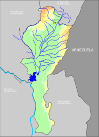
Cesar River
The Cesar River is a river in northern Colombia which is a part of the Magdalena Basin. It separates the Sierra Nevada de Santa Marta from the mountain ranges of the Serrania del Perija an extension of the Cordillera Oriental...
. The valley that its basin covers is also named after the river and extends through most of the department. The department of Cesar was created in 1967 by decree and the name officially adopted.
Geography
Department of La Guajira
La Guajira is a department of Colombia. It occupies most of its namesake peninsula, the Guajira Peninsula in the northeast region of the country, facing the Caribbean Sea and Venezuela in the northern most part of South America...
, to the east with the Bolivarian Republic of Venezuela, to the west with the department of Magdalena, to the southwest with the Department of Bolivar and to the south with the departments of North Santander
Department of North Santander
North Santander is a department of Colombia. It is in the north of the country, bordering Venezuela. Its capital is Cúcuta, one of the major cities of Colombia....
and Santander covering a total area of 22,905 km².
The majority of the Department is flat in 57% of the total area and 43% mountainous mainly in the Serrania del Perija and the Sierra Nevada de Santa Marta mountain ranges.
Ecoregions
The Department of Cesar contains five EcoregionEcoregion
An ecoregion , sometimes called a bioregion, is an ecologically and geographically defined area that is smaller than an ecozone and larger than an ecosystem. Ecoregions cover relatively large areas of land or water, and contain characteristic, geographically distinct assemblages of natural...
s; the Serrania del Perija
Serrania del Perija
The Serranía del Perijá, Cordillera de Perijá or Sierra de Perijá is a mountain range, an extension of the eastern Andean branch , in northern South America, between Colombia and Venezuela, ending further north in the Guajira Desert, a total distance of about 310 km...
mountain range, the valley of the Cesar River
Cesar River
The Cesar River is a river in northern Colombia which is a part of the Magdalena Basin. It separates the Sierra Nevada de Santa Marta from the mountain ranges of the Serrania del Perija an extension of the Cordillera Oriental...
, the Sierra Nevada de Santa Marta
Sierra Nevada de Santa Marta
The Sierra Nevada de Santa Marta is an isolated mountain range apart from the Andes chain that runs through Colombia. Reaching an altitude of 5,700 metres above sea level just 42 km from the Caribbean coast, the Sierra Nevada is the world's highest coastal range...
mountain range, the valley of the Magdalena River
Magdalena River
The Magdalena River is the principal river of Colombia, flowing northward about through the western half of the country. It takes its name from the biblical figure Mary Magdalene. It is navigable through much of its lower reaches, in spite of the shifting sand bars at the mouth of its delta, as...
and the Cienaga de Zapatosa
Ciénaga de Zapatosa
Ciénaga de Zapatosa is a large marsh in a depression located between the Colombian departments of Cesar and Magdalena covering an area of approximately 40,000 ha and containing one million cubic meters of water....
marsh
Marsh
In geography, a marsh, or morass, is a type of wetland that is subject to frequent or continuous flood. Typically the water is shallow and features grasses, rushes, reeds, typhas, sedges, other herbaceous plants, and moss....
es complex.
Serrania del Perija mountain range
The Serrania del PerijaSerrania del Perija
The Serranía del Perijá, Cordillera de Perijá or Sierra de Perijá is a mountain range, an extension of the eastern Andean branch , in northern South America, between Colombia and Venezuela, ending further north in the Guajira Desert, a total distance of about 310 km...
mountain range covers most of the eastern side of the Department of Cesar between its border with Venezuela and the Department of North Santander
Department of North Santander
North Santander is a department of Colombia. It is in the north of the country, bordering Venezuela. Its capital is Cúcuta, one of the major cities of Colombia....
, approximately 300 km in length penetrating into the Department of La Guajira
Department of La Guajira
La Guajira is a department of Colombia. It occupies most of its namesake peninsula, the Guajira Peninsula in the northeast region of the country, facing the Caribbean Sea and Venezuela in the northern most part of South America...
to the north and covering 27% of the total area of Cesar. The Serrania del Perija covers, partially or totally the area of 17 municipalities in the Department of Cesar; Aguachica, Codazzi, Becerril, Chimichagua, Chiriguana, Curumani, Gonzalez, La Gloria, La Jagua de Ibirico, Los Robles La Paz, Manaure, Pailitas, Pelaya, Rio de Oro, San Alberto, San Diego and San Martin. There are also the indigenous reserves pertaining to the Yukpa
Yukpa
Yukpa is an Amerindian ethnic group that inhabits the northeastern part of the Cesar Department in northern Colombia by the Serrania del Perija bordering Venezuela. Their territory covers the eastern areas of the municipalities of Robles La Paz, Codazzi and Becerril in Resguardos named Socorpa,...
s people; Iroka, Socorpa and Menkue-Misaya-La Pista; and to the Wiwas people; Caño Padilla, El Rosario-Bella Vista-Yucatán and Campoalegre.
Approximately 70% of the mountain range preserves unique flora and fauna and some 20 rivers are born in the mountain range among other minor streams, flowing into the Department of Cesar and feeding the Magdalena and Cesar river basins and the Cienaga de Zapatosa marshes. The Colombian government declared it a National Forest Reserve.
Sierra Nevada de Santa Marta mountain range
Guatapurí River
The Guatapurí River, or Rio Guatapurí in Spanish, is a river that flows from the eastern side of the Sierra Nevada de Santa Marta into the Cesar River in northern Colombia by the city of Valledupar....
, Badillo, Ariguani
Ariguaní River
Ariguaní River is a river in northern Colombia's Caribbean Region born in the Sierra Nevada de Santa Marta mountain range in the area of the municipality of Pueblo Bello. The Ariguaní is an affluent of the Cesar River and flows from north to south into it near the town of El Paso...
, Cesarito, Los Clavos, Garupal and Rio Seco rivers. The mountains are within the boundaries of the municipalities of Pueblo Bello, Valledupar, El Copey and Bosconia.
The Sierra Nevada de Santa Marta was declared by UNESCO
UNESCO
The United Nations Educational, Scientific and Cultural Organization is a specialized agency of the United Nations...
as a Biosphere Reserve on October 29, 1993.
Climate
Climate in the Department of Cesar presents variations in climate depending on altitude, as well as rainfall precipitations. Mountain climate in the Sierra Nevada de Santa Marta and the Serrania del Perija cools downs the higher the altitude reachin freezing low temperatures at the snowy peaks and the region has two rainy seasons and two dry seasons, averaging a temperature throughout the year of 28°C. Lower lands present a warm and dry climate, annual precipitations are less than 1,300 mm a year. The mountainous regions are characterized by low temperatures with snow at high altitude peaks and precipitations ranging more than 2,000 mm a year.Pre-Columbian
The region was first inhabited by indigenous peoples known as Euparíes in the Valley of Upar and Guatapuríes in the Valley of the Cesar river, among these were the Orejones pertaining to the Tupe, Acanayutos pertaining to the Motilones and Alcoholados pertaining to the Chimilas.Spanish chronicles describe the tribes as being part of a federation of tribes led by Caciques, with the village of Eupari as the largest and central to the other villages. These tribes are believed to be related to the Mesoamerica
Mesoamerica
Mesoamerica is a region and culture area in the Americas, extending approximately from central Mexico to Belize, Guatemala, El Salvador, Honduras, Nicaragua, and Costa Rica, within which a number of pre-Columbian societies flourished before the Spanish colonization of the Americas in the 15th and...
n culture, the Caribs and Arawaks, directly associated to the Muisca
Muisca
Muisca was the Chibcha-speaking tribe that formed the Muisca Confederation of the central highlands of present-day Colombia. They were encountered by the Spanish Empire in 1537, at the time of the conquest...
culture in the Colombian eastern branch of the Andes
Andes
The Andes is the world's longest continental mountain range. It is a continual range of highlands along the western coast of South America. This range is about long, about to wide , and of an average height of about .Along its length, the Andes is split into several ranges, which are separated...
.
Archeological findings has shown that the indigenous in the area worked with stones and wood, including a boomerang
Boomerang
A boomerang is a flying tool with a curved shape used as a weapon or for sport.-Description:A boomerang is usually thought of as a wooden device, although historically boomerang-like devices have also been made from bones. Modern boomerangs used for sport are often made from carbon fibre-reinforced...
shaped weapon found in a cemetery at Los Robles La Paz
Los Robles La Paz
Los Robles La Paz or simply La Paz is a municipality and a town in the Department of Cesar, Colombia. The town is close to the Capital city of the Department of Cesar; Valledupar. The municipality of La Paz borders to the north with La Guajira Department, to the northeast with the municipality of...
.
Spanish conquest and colonization
The first European to explore the area was Spanish Captain Pedro de Vadillo, but German Ambrosio Alfínger savagely conquered the region in 1531. In 1550 the village of Valle de Upar was founded by Hernando de SantanaHernando de Santana
Hernando de Santana was a Spanish conqueror, the founder of the City of Valledupar and conqueror in what is now northern Colombia....
and Juan de Castellanos
Juan de Castellanos
Juan de Castellanos was a Criollo poet, soldier and Catholic priest.He travelled to America before 1545 as a cavalry soldier, and acquired some property on the Pearl Coast...
.
Republican era
In 1813, María de la Concepción Loperena proclaimed the independence of Valledupar and donated 300 horses to Simon BolivarSimón Bolívar
Simón José Antonio de la Santísima Trinidad Bolívar y Palacios Ponte y Yeiter, commonly known as Simón Bolívar was a Venezuelan military and political leader...
. In 1829 Valledupar became a Cantón of the Province of Santa Marta. By Law 15 of 1850, Valledupar was segregated frim Santa Marta becoming the Province of Valledupar. In 1857 became a province of the State of Magdalena and by Law of December 29, 1864 became the Department of Valledupar pertaining to State of Magdalena. On December 27, 1967 the Department of Cesar was created officially.
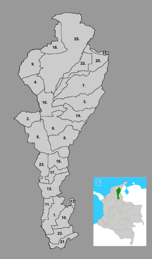
Municipalities
The Department of Cesar is formed by 25 municipalities, some 171 corregimientos, 990 veredas and 10 indigenous reserves. For administrative reasons the Department of Cesar is subdivided into 4 strategic regions; the Northern Subregion covering the municipalties of Valledupar, Codazzi, Pueblo Bello, La Paz, Manaure and San Diego. The Northwestern Subregion covering the municipalities of Bosconia, El Copey, El Paso and Astrea. The Central Subregion covering the municipalities of Curumani, Becerril, Chiriguana, La Jagua de Ibirico, Chimichagua, Tamalameque and Pailitas; and the Southern Subregion covering the municipalities of Aguachica, Gamarra, Gonzalez, La Gloria, Pelaya, Rio de Oro, San Alberto and San Martin.| Municipalities | Map |
|---|---|
|
 |


.png)
.png)


Economy
Commerce
While business refers to the value-creating activities of an organization for profit, commerce means the whole system of an economy that constitutes an environment for business. The system includes legal, economic, political, social, cultural, and technological systems that are in operation in any...
and mining
Mining
Mining is the extraction of valuable minerals or other geological materials from the earth, from an ore body, vein or seam. The term also includes the removal of soil. Materials recovered by mining include base metals, precious metals, iron, uranium, coal, diamonds, limestone, oil shale, rock...
. Cattle raising is exploited extensively (using large farms), and for this reason large portions of forest
Forest
A forest, also referred to as a wood or the woods, is an area with a high density of trees. As with cities, depending where you are in the world, what is considered a forest may vary significantly in size and have various classification according to how and what of the forest is composed...
s have been chopped off to create corral
Corral
Corral is a town, commune and sea port in Los Ríos Region, Chile. It is located south of Corral Bay. Corral is best known for the forts of Corral Bay, a system of defensive batteries and forts made to protect Valdivia during colonial times. Corral was the headquarters of the system...
s. In agriculture
Agriculture
Agriculture is the cultivation of animals, plants, fungi and other life forms for food, fiber, and other products used to sustain life. Agriculture was the key implement in the rise of sedentary human civilization, whereby farming of domesticated species created food surpluses that nurtured the...
, plantations of cotton
Cotton
Cotton is a soft, fluffy staple fiber that grows in a boll, or protective capsule, around the seeds of cotton plants of the genus Gossypium. The fiber is almost pure cellulose. The botanical purpose of cotton fiber is to aid in seed dispersal....
, rice
Rice
Rice is the seed of the monocot plants Oryza sativa or Oryza glaberrima . As a cereal grain, it is the most important staple food for a large part of the world's human population, especially in East Asia, Southeast Asia, South Asia, the Middle East, and the West Indies...
, sugar cane, oil palm
Oil palm
The oil palms comprise two species of the Arecaceae, or palm family. They are used in commercial agriculture in the production of palm oil. The African Oil Palm Elaeis guineensis is native to West Africa, occurring between Angola and Gambia, while the American Oil Palm Elaeis oleifera is native to...
, cassava
Cassava
Cassava , also called yuca or manioc, a woody shrub of the Euphorbiaceae native to South America, is extensively cultivated as an annual crop in tropical and subtropical regions for its edible starchy tuberous root, a major source of carbohydrates...
and plantain
Plantain
Plantain is the common name for herbaceous plants of the genus Musa. The fruit they produce is generally used for cooking, in contrast to the soft, sweet banana...
. Services are centered on commerce and the industry is represented by oil products
Oil
An oil is any substance that is liquid at ambient temperatures and does not mix with water but may mix with other oils and organic solvents. This general definition includes vegetable oils, volatile essential oils, petrochemical oils, and synthetic oils....
, fat
Fat
Fats consist of a wide group of compounds that are generally soluble in organic solvents and generally insoluble in water. Chemically, fats are triglycerides, triesters of glycerol and any of several fatty acids. Fats may be either solid or liquid at room temperature, depending on their structure...
s and milk
Milk
Milk is a white liquid produced by the mammary glands of mammals. It is the primary source of nutrition for young mammals before they are able to digest other types of food. Early-lactation milk contains colostrum, which carries the mother's antibodies to the baby and can reduce the risk of many...
derived products. As one of the biggest water resources
Water resources
Water resources are sources of water that are useful or potentially useful. Uses of water include agricultural, industrial, household, recreational and environmental activities. Virtually all of these human uses require fresh water....
areas of Colombia
Colombia
Colombia, officially the Republic of Colombia , is a unitary constitutional republic comprising thirty-two departments. The country is located in northwestern South America, bordered to the east by Venezuela and Brazil; to the south by Ecuador and Peru; to the north by the Caribbean Sea; to the...
, if not America, part of the Magdalena River
Magdalena River
The Magdalena River is the principal river of Colombia, flowing northward about through the western half of the country. It takes its name from the biblical figure Mary Magdalene. It is navigable through much of its lower reaches, in spite of the shifting sand bars at the mouth of its delta, as...
crosses the Department and helps create the Cienaga de Zapatosa
Ciénaga de Zapatosa
Ciénaga de Zapatosa is a large marsh in a depression located between the Colombian departments of Cesar and Magdalena covering an area of approximately 40,000 ha and containing one million cubic meters of water....
(Zapatosa Marsh
Marsh
In geography, a marsh, or morass, is a type of wetland that is subject to frequent or continuous flood. Typically the water is shallow and features grasses, rushes, reeds, typhas, sedges, other herbaceous plants, and moss....
) along with the Cesar river. It has a great potential to develop a fishing industry
Fishing industry
The fishing industry includes any industry or activity concerned with taking, culturing, processing, preserving, storing, transporting, marketing or selling fish or fish products....
also, but it is practiced at a minimum. Most of the territory has not been explored in the search of more minerals due to violence, but because of recent findings, it became a potential source.http://www.banrep.gov.co/docum/Pdf-econom-region/Documentos/DTSER-59.pdf
External links
- Cesar 30 Años de Progreso - Gobernacion del Cesar (1997) booklet
- Cesar Department official website
- INGEOMINAS: Geography of the Department of Cesar
- Poverty in the Department of Cesar
- Forced displacement in the Department of Cesar