
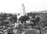
Aguachica
Encyclopedia
Aguachica, is a small city and municipality in the southern region of the Cesar Department
, Colombia
. It was officially founded on August 16, 1748 by José Lázaro de Rivera.
, between the Cordillera Oriental Andean
mountains and the Magdalena River
. The municipality of Aguachica borders to the north with the municipality of La Gloria
and the Department of North Santander
(municipality of El Carmen
); to the east with the municipality of Rio de Oro
; to the south with Rio de Oro once again, with the municipality of San Martín
and the Department of Santander (municipality of Puerto Wilches
) and to the west with the municipality of Gamarra
and the Department of Bolívar (municipality of Morales
) covering a total area of 876 km², 3.8% of the total area of the Department of Cesar.
The northern area of the municipality is mountainous part of the Cordillera Oriental mountain range with altitude variating between the 200 m and 2,150 m over sea level. The southern area of the municipality of Aguachica is predominantly flat with two major rivers flowing through the region; the Magdalena River
and the Lebrija River.
de San Roque by the Spanish and was owned by Don Antonio Garia de Bonilla, but due to pests and illnesses the settlement was moved a few hundred meters to the south. By 1722 the settlement had grown in the middle of an hacienda predominantly owned by Don Casimiro Ramos de Barahoja. The settlement was serving now as a rest area for merchants traveling to and from the nearby fluvial port town of Gamarra
and Ocaña
(present-day Department of North Santander
).
On August 17, 1748 the settlement was officially founded by Jose Lazaro de Rivera and established as a Roman Catholic parish
. By this time the Spanish conqueror Jose Fernando de Mier y Guerra was ordered to "pacify" the Chimilas indigenous groups and to reorganize some villages in the basin of the Magdalena river. These foundations and re-foundations were approved back then by José Alfonso Pizarro
viceroy
of the Viceroyalty of New Granada
between 1749 and 1753. In 1753 the Spanish ordered the construction of houses in Aguachica and was made part of the Government of Santa Marta.
Between 1798 and 1804 a plague swept most of the population causing the village to move to its present location. In 1914 became a municipality.
in neighboring Ocaña, Sovereign State of Santander and also introduced agricultural and farming practices for commerce in the region. During the 1920s, Petroleum
deposits were found in the area triggering another wave of migrants mostly from the neighboring departments of Colombia; Antioquia, Caldas, Santander, North Santander
and Boyaca.
During the 1950s the construction of the highway and the Magdalena railroad turned Aguachica into a strategic area between the Andean region
and Caribbean region. The 1960s were marked by the migration of people from the Department of Tolima
mostly farmers interested on exploiting the land, developing large plantations of cotton
, sorghum
, rice
, among other products. The economy grew, developing an economy based on agricultural products, commerce and services.
producing the displacement of people from the countryside and from neighboring regions of the southern Department of Bolívar and the Department of Cesar into the municipality seat.
The majority of the population 51% is female while 49% are male. Of these 0.1% considered itself of indigenous ancestry and 3.7% of Afro-Colombian
ancestry.
87% of these 80,789 people living in houses, while 2.1% lived in apartment buildings and 10% in rented rooms. 4.8% of these homes were also used for home businesses. 90% of the municipality of Aguachica had electricity, 73% with sewage service, 87% had aqueduct services, 50% had natural gas services installed at home while 30% percent had a telephone line.
Cesar Department
Cesar Department or simply Cesar is a department of Colombia located in the north of the country in the Caribbean region, bordering to the north with the Department of La Guajira, to the west with the Department of Magdalena and Department of Bolivar, to the south with Department of Santander, to...
, Colombia
Colombia
Colombia, officially the Republic of Colombia , is a unitary constitutional republic comprising thirty-two departments. The country is located in northwestern South America, bordered to the east by Venezuela and Brazil; to the south by Ecuador and Peru; to the north by the Caribbean Sea; to the...
. It was officially founded on August 16, 1748 by José Lázaro de Rivera.
Geography
The municipality is located south of the Cesar DepartmentCesar Department
Cesar Department or simply Cesar is a department of Colombia located in the north of the country in the Caribbean region, bordering to the north with the Department of La Guajira, to the west with the Department of Magdalena and Department of Bolivar, to the south with Department of Santander, to...
, between the Cordillera Oriental Andean
Andes
The Andes is the world's longest continental mountain range. It is a continual range of highlands along the western coast of South America. This range is about long, about to wide , and of an average height of about .Along its length, the Andes is split into several ranges, which are separated...
mountains and the Magdalena River
Magdalena River
The Magdalena River is the principal river of Colombia, flowing northward about through the western half of the country. It takes its name from the biblical figure Mary Magdalene. It is navigable through much of its lower reaches, in spite of the shifting sand bars at the mouth of its delta, as...
. The municipality of Aguachica borders to the north with the municipality of La Gloria
La Gloria
La Gloria is a municipality and town in the Department of Cesar, northern Colombia by the Magdalena River.-Geography:La Gloria is situated to the Eastern margin of the Magdalena River, it borders the north with the municipalities of Tamalameque and Pelaya, the south with the municipalities of...
and the Department of North Santander
Department of North Santander
North Santander is a department of Colombia. It is in the north of the country, bordering Venezuela. Its capital is Cúcuta, one of the major cities of Colombia....
(municipality of El Carmen
El Carmen, Norte de Santander
El Carmen is a Colombian municipality located in the department of North Santander.-References:...
); to the east with the municipality of Rio de Oro
Río de Oro, Cesar
Río de Oro is a town and municipality in the Colombian Department of Cesar.-External links:...
; to the south with Rio de Oro once again, with the municipality of San Martín
San Martín, Cesar
San Martín is a town and municipality in the Colombian Department of Cesar.-External links:...
and the Department of Santander (municipality of Puerto Wilches
Puerto Wilches
Puerto Wilches is a town and municipality in the Santander Department in northeastern Colombia....
) and to the west with the municipality of Gamarra
Gamarra
Gamarra is a town and municipality in the Colombian Department of Cesar.-External links:*...
and the Department of Bolívar (municipality of Morales
Morales, Bolívar
Morales is a town and municipality located in the Bolívar Department, northern Colombia.-References:...
) covering a total area of 876 km², 3.8% of the total area of the Department of Cesar.
The northern area of the municipality is mountainous part of the Cordillera Oriental mountain range with altitude variating between the 200 m and 2,150 m over sea level. The southern area of the municipality of Aguachica is predominantly flat with two major rivers flowing through the region; the Magdalena River
Magdalena River
The Magdalena River is the principal river of Colombia, flowing northward about through the western half of the country. It takes its name from the biblical figure Mary Magdalene. It is navigable through much of its lower reaches, in spite of the shifting sand bars at the mouth of its delta, as...
and the Lebrija River.
Pre-Columbian
The territory of present day Aguachica was inhabited by amerindian Chimila tribes, before the Spanish conquerors arrived. This tribe was later brutally decimated by the Spanish.Spanish conquest and colonization
During the first decades of the 18th century, the area was established as the HaciendaHacienda
Hacienda is a Spanish word for an estate. Some haciendas were plantations, mines, or even business factories. Many haciendas combined these productive activities...
de San Roque by the Spanish and was owned by Don Antonio Garia de Bonilla, but due to pests and illnesses the settlement was moved a few hundred meters to the south. By 1722 the settlement had grown in the middle of an hacienda predominantly owned by Don Casimiro Ramos de Barahoja. The settlement was serving now as a rest area for merchants traveling to and from the nearby fluvial port town of Gamarra
Gamarra
Gamarra is a town and municipality in the Colombian Department of Cesar.-External links:*...
and Ocaña
Ocaña, Colombia
Ocaña is a town and municipality in the Colombian Department of Norte de Santander. Ocaña is the second largest populated center of this department. It played an important role during the Independence of Colombia from the Spanish monarchy.-History:...
(present-day Department of North Santander
Department of North Santander
North Santander is a department of Colombia. It is in the north of the country, bordering Venezuela. Its capital is Cúcuta, one of the major cities of Colombia....
).
On August 17, 1748 the settlement was officially founded by Jose Lazaro de Rivera and established as a Roman Catholic parish
Parish
A parish is a territorial unit historically under the pastoral care and clerical jurisdiction of one parish priest, who might be assisted in his pastoral duties by a curate or curates - also priests but not the parish priest - from a more or less central parish church with its associated organization...
. By this time the Spanish conqueror Jose Fernando de Mier y Guerra was ordered to "pacify" the Chimilas indigenous groups and to reorganize some villages in the basin of the Magdalena river. These foundations and re-foundations were approved back then by José Alfonso Pizarro
José Alfonso Pizarro
José Alfonso Pizarro, Marqués del Villar was a Spanish naval officer and colonial administrator. From November 6, 1749 to November 24, 1753 he was viceroy of the Spanish Viceroyalty of New Granada.As a youth he entered the naval service of the Knights of Malta...
viceroy
Viceroy
A viceroy is a royal official who runs a country, colony, or province in the name of and as representative of the monarch. The term derives from the Latin prefix vice-, meaning "in the place of" and the French word roi, meaning king. A viceroy's province or larger territory is called a viceroyalty...
of the Viceroyalty of New Granada
Viceroyalty of New Granada
The Viceroyalty of New Granada was the name given on 27 May 1717, to a Spanish colonial jurisdiction in northern South America, corresponding mainly to modern Colombia, Ecuador, Panama, and Venezuela. The territory corresponding to Panama was incorporated later in 1739...
between 1749 and 1753. In 1753 the Spanish ordered the construction of houses in Aguachica and was made part of the Government of Santa Marta.
Between 1798 and 1804 a plague swept most of the population causing the village to move to its present location. In 1914 became a municipality.
Republicanism
By 1850 the first migrants arrived to Aguachica largely attracted by the plantations of coffeeCoffee
Coffee is a brewed beverage with a dark,init brooo acidic flavor prepared from the roasted seeds of the coffee plant, colloquially called coffee beans. The beans are found in coffee cherries, which grow on trees cultivated in over 70 countries, primarily in equatorial Latin America, Southeast Asia,...
in neighboring Ocaña, Sovereign State of Santander and also introduced agricultural and farming practices for commerce in the region. During the 1920s, Petroleum
Petroleum
Petroleum or crude oil is a naturally occurring, flammable liquid consisting of a complex mixture of hydrocarbons of various molecular weights and other liquid organic compounds, that are found in geologic formations beneath the Earth's surface. Petroleum is recovered mostly through oil drilling...
deposits were found in the area triggering another wave of migrants mostly from the neighboring departments of Colombia; Antioquia, Caldas, Santander, North Santander
Department of North Santander
North Santander is a department of Colombia. It is in the north of the country, bordering Venezuela. Its capital is Cúcuta, one of the major cities of Colombia....
and Boyaca.
During the 1950s the construction of the highway and the Magdalena railroad turned Aguachica into a strategic area between the Andean region
Andean Region of Colombia
The Andes mountains form the most populated region of Colombia and contain the majority of the country's urban centres. They were also the location of the most significant pre-Columbian indigenous settlement...
and Caribbean region. The 1960s were marked by the migration of people from the Department of Tolima
Department of Tolima
Tolima is one of the 32 departments of Colombia, located in the Andean region, in the center-west of the country. It is bordered on the north and the west by the department of Caldas; on the east by the department of Cundinamarca; on the south by the department of Huila, and on the west by the...
mostly farmers interested on exploiting the land, developing large plantations of cotton
Cotton
Cotton is a soft, fluffy staple fiber that grows in a boll, or protective capsule, around the seeds of cotton plants of the genus Gossypium. The fiber is almost pure cellulose. The botanical purpose of cotton fiber is to aid in seed dispersal....
, sorghum
Sorghum
Sorghum is a genus of numerous species of grasses, one of which is raised for grain and many of which are used as fodder plants either cultivated or as part of pasture. The plants are cultivated in warmer climates worldwide. Species are native to tropical and subtropical regions of all continents...
, rice
Rice
Rice is the seed of the monocot plants Oryza sativa or Oryza glaberrima . As a cereal grain, it is the most important staple food for a large part of the world's human population, especially in East Asia, Southeast Asia, South Asia, the Middle East, and the West Indies...
, among other products. The economy grew, developing an economy based on agricultural products, commerce and services.
Colombian armed conflict
During the 1980s and early 1990s the region was influenced by the Colombian armed conflictColombian Armed Conflict
The Colombian armed conflict or Colombian Civil War are terms that are employed to refer to the current asymmetric low-intensity armed conflict in Colombia that has existed since approximately 1964 or 1966, between the Colombian government and peasant guerrillas such as the Revolutionary Armed...
producing the displacement of people from the countryside and from neighboring regions of the southern Department of Bolívar and the Department of Cesar into the municipality seat.
Corregimientos
- Barranca Lebrija
- Boqueron
- Buturama
- Cerro Bravo
- Cerro Redondo
- Cuatro Rocas
- El Juncal
- La Morena
- Las Adjuntas
- Lucaical
- Norean
- San Miguel
- Santa Lucia
- Villa Nueva
- La Campana
- Las Juntas
- La Yegüera
- Loma de Corredor
- Mucuras
- Patiño
- Pitalimon
- Puerto Amalia
- San Andres de Totumal
- San Francisco
- Santa Barbara
- Santa Rosa
- Soledad
- Torcoroma
- Villa de San Andres
- Villanueva
Veredas
- Barcelona
- Bombadiero
- Cañada Ospina
- Caracol
- Costa Rica
- El Corral
- El Tope
- Esmeralda Alta
- Honduras
- Cascabela
- La Pajuila
- La Ye
- Las Bateas
- Bella Vista
- Capoalegre
- Caño Caracoli
- Cerro de los Bustos
- El Carbon
- El Faro
- Esmeralda
- Guaduas
- La Bocatoma
- La Ceiba
- La Union
- La Yeguerita
- Las Latas
Demographics
In the 2005 Cesus by the DANE the municipality of Aguachica had a total population of 80,789.The majority of the population 51% is female while 49% are male. Of these 0.1% considered itself of indigenous ancestry and 3.7% of Afro-Colombian
Afro-Colombian
Afro Colombians refers to Colombians of African ancestry, and the great impact they have had on Colombian culture. Notable Afro-Colombians include Colombian scientists like Raul Cuero, writers like Manuel Zapata Olivella and politicians:...
ancestry.
87% of these 80,789 people living in houses, while 2.1% lived in apartment buildings and 10% in rented rooms. 4.8% of these homes were also used for home businesses. 90% of the municipality of Aguachica had electricity, 73% with sewage service, 87% had aqueduct services, 50% had natural gas services installed at home while 30% percent had a telephone line.