

Capelinhos
Encyclopedia
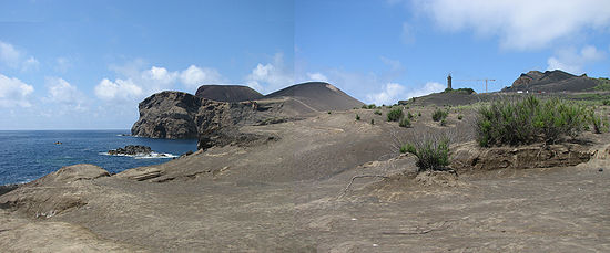
The Capelinhos is a monogenetic volcano
located on the western coast of the island of Faial
in the Azores
. It is part of the larger Volcanic Complex of Capelo, that includes 20 escoria cones and lava fields that are aligned west-northwest to east-southeast from the Cabeço Gordo
caldera. Although the name "Capelinhos" is associated with the volcano, it technically refers to the western cape of the parish of Capelo
.
A volcanic eruption lasted for 13 months, from September 27, 1957 until October 24, 1958, which may have been two overlapping volcanic eruptions. While enlarging the land by 2.4 km², it spawned 300 seismic events, hurled ash 1 km, destroyed 300 houses in the parishes of Capelo
and Praia do Norte
and caused the evacuation of 2,000 people (emigration to the US
and Canada
). On October 25, the volcano entered a period of dormancy. Although it is not considered potentially active, it is a part of an active fissural volcanic complex.
, Strombolian
and Hawaiian
volcanic types. The formation is composed primarily of basaltic rocks, although, less frequently, Hawaiian hawaiitic rocks are observed.
Capelinhos is classified a Surtseyan eruption
, since it was formed in the relatively shallow coast of the Faial seamount. Ironically, the volcano pre-dates the Surtseyan definition, which was first attributed to the submarine eruption of the volcano Surtsey
five years later; some refer to this type of eruption as Capelinian.
Located at Cabeço Norte, a volcanic vent releases water vapour with temperatures between 180°C and 200°C from the volcano complex.
 The Capelinhos volcano was a seminal event; "it was a submarine eruption intensely observed, documented and studied from its beginning to end. It appeared under ideal conditions and across from an inhabited island, with roads, a lighthouse and private telephones", first commented by vulcanologist Victor Hugo Forjaz. The first activities during the eruption were identified by engineer Frederico Machado, the Director of the District Public Works Department, his assistant engineer João do Nascimento and surveyor António Denis, under the authorization of the Civil Governor, Freitas Pimentel. The Director of the Observatory in Angra
, Lieutenant-Colonel José Agostinho overflew the area, and Bernado Almada (at the Prince Albert of Monaco Observatory, in Horta) sent several bulletins relating the increased seismic activity of the area.
Between September 16 and 27, 1957, 200 earthquakes of a level 5 on the Meracalli scale
were registered. On September 23, the ocean waters off the coast of Ponte dos Capelinhos began to boil, the first vapours were witnessed around 6:30 a.m. one kilometre northwest of the lighthouse. A constant tremor could be sensed, at times reaching a Level IV on the Mercalli scale (MM-31). Three days later, the activity increased; black ash (to about 1400 m) and water vapour (to about 4000 m) rose west of the two ilhéus (islets) off the coast. On September 27, beginning at about 6:45 in the morning, a submarine eruption, 300 m from Ponta dos Capelinhos (100 m from the Ilhéus dos Capelinhos) began. Whale spotters at Costado da Nau, a few meters above the Capelinhos lighthouse, saw the ocean churning to the west and alerted the lighthouse keepers. On October 5: "...the clouds of clay likely rose about one kilometre in height and solid fragments...reaching a area of 1200 metres around..." The buildings in the area began to experience the first damages: windows were broken, tiles fell from the roofs. By the next day, the first ash-fall began on land; "in a few hours a black mat covered the extreme West of island..."., reaching 2.5 kilometres from the crater, necessitating the evacuation of the settlements of Norte Pequeno and Canto. Initially, gases and pyroclastic explosions persisted until October 13, while gradually diminishing, but were rapidly replaced by violent explosions, lava bombs, ash and lava streaming into the sea. This intense eruption occurred until the end of October with constant ash raining on Faial, destroying cultural lands, inhibiting normal farming and forcing the residents from local villages to evacuate.
By October 10, the eruption had initially formed a small island, baptized Ilha Nova (the New Island), Ilha dos Capelinhos (Island of Capelinhos) or Ilha do Espírito Santo (Island of the Holy Sprit) by the locals, 600 meter diameter and 30 meter height with an open crater to the sea. By October 29, the island grew to 99 meters high and 800 meters in diameter of coarse black ash.
By the end of the first phase of the eruption, a memorable public event occurred. Three reporters, Carlos Tudela and Vasco Hogan Teves (from public television RTP
), journalist Urbano Carrasco (from the newspaper Diário Popular) and accompanied by boat pilot Carlos Raulino Peixoto risked their lives by traveling to the Ilha Nova. Arriving on the island, they implanted a Portuguese flag, before hurriedly getting on the boat and rowing back. But, the New Island had disappeared into the sea by 30 October.
On November 4, 1957 a second volcanic event occurred rapidly, forming a second island, and by the 12 November 1957 an isthmus
had formed linking Faial. Explosions and ejecta increased progressively, reaching a crescendo by 15 December when a second cone was formed. Following a night of torrential rains and ash (on or about 16 November) the explosive activity ceased, and an effusive lava phase began with more ash and explosive rock. By then the largest eruptive column had reached 1450 metres into the air, carrying with it ash from the northwest for a distance of 20 kilometres (6 December). A final pause began on 29 December.
Between January and April 1958, new showers of ash and accompanying water vapour (both white and darkened) persisted, and the two Ilhéus off the coast of Ponte dos Capelinhos had disappeared under the sand and ash. During this period the cinder cone and isthmus became an integral part of the island of Faial, destroying the roofs of the local buildings and infilling the space to the lighthouse. From May 12–18, 450 seismic events were recorded as the volcano moved into a Strombolian phase, emitting projectiles 500 m into the air, causing moderate explosions and accompanied by infra-sonic waves that shook doors and windows on the island and some adjacent islands. This final phase lasted several months: the last lava currents were visible on 21 October, and the last projectiles were reported on 24 October.
During this final stage (around 14 May), fumaroles were discovered inside Faial's caldera
(Portuguese: Caldeira), that began emitting sulfurous water vapor, boiling clay and mud.
Although one person nearly fell into the Capelinhos crater, there were no deaths from the eruption; generally, ash deposits and some projectiles caused the destruction of homes and the blanketing of agricultural lands in the parishes of Capelo
and Praia do Norte
. A report presented on 15 January 1958 indicated that 164 families had been affected by the eruption.
Due to the close relationship between Portugal and the United States, refugees from the beleaguered parishes emigrated. The Azorean Refugee Act (September 2, 1958), authorized the emigration of 1,500 people and was sponsored by Congressmen Joseph Perry Jr. and John Pastor of Rhode Island
, and a young Senator John F. Kennedy
of Massachusetts
. In addition to many families from the area of Capelo, other citizens of the Azores benefited from these temporary measures. This specifically resulted in a 50% decrease of the resident population of Capelo, and contributed to an increased standard of living, greater working opportunities and some improvements in base incomes.
and Visitors Center (which lies along the cliff from the volcano) is a tourist destination. Although the volcano is dangerous (due to its dormant state and relief), a trail network runs from the Visitors Center and lighthouse to the caldera summit. On September 27, 2007, commemorations marked the 50th anniversary of the eruption and its effects on the islands history and people (which was broadcast in Portugal and throughout the Azorean diaspora).
Volcano
2. Bedrock3. Conduit 4. Base5. Sill6. Dike7. Layers of ash emitted by the volcano8. Flank| 9. Layers of lava emitted by the volcano10. Throat11. Parasitic cone12. Lava flow13. Vent14. Crater15...
located on the western coast of the island of Faial
Faial Island
Faial Island , also known in English as Fayal, is a Portuguese island of the Central Group of the Azores....
in the Azores
Azores
The Archipelago of the Azores is composed of nine volcanic islands situated in the middle of the North Atlantic Ocean, and is located about west from Lisbon and about east from the east coast of North America. The islands, and their economic exclusion zone, form the Autonomous Region of the...
. It is part of the larger Volcanic Complex of Capelo, that includes 20 escoria cones and lava fields that are aligned west-northwest to east-southeast from the Cabeço Gordo
Cabeço Gordo
Cabeço Gordo is the highest mountain, massive stratovolcano and the largest geomorphological structure that forms the island of Faial. The mountain/volcano is 1,043 meters above sea level, consisting of a two kilometer wide caldera, that is 400 m in depth below the crater rim...
caldera. Although the name "Capelinhos" is associated with the volcano, it technically refers to the western cape of the parish of Capelo
Capelo
Capelo is a civil parish in the municipality of Horta on the island of Faial in the Azorean archipelago. The population as of 2001 was approximately 493, its density is 19/km² and the area is 25.93 km²...
.
A volcanic eruption lasted for 13 months, from September 27, 1957 until October 24, 1958, which may have been two overlapping volcanic eruptions. While enlarging the land by 2.4 km², it spawned 300 seismic events, hurled ash 1 km, destroyed 300 houses in the parishes of Capelo
Capelo
Capelo is a civil parish in the municipality of Horta on the island of Faial in the Azorean archipelago. The population as of 2001 was approximately 493, its density is 19/km² and the area is 25.93 km²...
and Praia do Norte
Praia do Norte
Praia do Norte is a civil parish of the municipality of Horta, located along the northern coast between Cedros and Capelo, on the island of Faial, Azores. It is one of the least populous parishes on the island, reaching 712 inhabitants in the 18th century, but generally about 250 people. It is...
and caused the evacuation of 2,000 people (emigration to the US
United States
The United States of America is a federal constitutional republic comprising fifty states and a federal district...
and Canada
Canada
Canada is a North American country consisting of ten provinces and three territories. Located in the northern part of the continent, it extends from the Atlantic Ocean in the east to the Pacific Ocean in the west, and northward into the Arctic Ocean...
). On October 25, the volcano entered a period of dormancy. Although it is not considered potentially active, it is a part of an active fissural volcanic complex.
Geography
Capelinhos is located along the Capelo Volcanic Complex, that comprises a western area of fissural volcanism and historical eruptions leading away from the Cabeço do Fogo. The events that began in 1957 were an extension of the volcanic activity that abruptly ended at Costado da Nau, the escarpment at Ponta dos Capelinhos. Similar to the Horta Platform, the peninsula is consistent with the shapes and products resulting from SurtseyanSurtseyan eruption
A Surtseyan eruption is a type of volcanic eruption that takes place in shallow seas or lakes. It is named after the island of Surtsey off the southern coast of Iceland....
, Strombolian
Strombolian eruption
Strombolian eruptions are relatively low-level volcanic eruptions, named after the Italian volcano Stromboli, where such eruptions consist of ejection of incandescent cinder, lapilli and lava bombs to altitudes of tens to hundreds of meters...
and Hawaiian
Hawaiian eruption
A Hawaiian eruption is a type of volcanic eruption where lava flows from the vent in a relative gentle, low level eruption, so called because it is characteristic of Hawaiian volcanoes. Typically they are effusive eruptions, with basaltic magmas of low viscosity, low content of gases, and high...
volcanic types. The formation is composed primarily of basaltic rocks, although, less frequently, Hawaiian hawaiitic rocks are observed.
Capelinhos is classified a Surtseyan eruption
Surtseyan eruption
A Surtseyan eruption is a type of volcanic eruption that takes place in shallow seas or lakes. It is named after the island of Surtsey off the southern coast of Iceland....
, since it was formed in the relatively shallow coast of the Faial seamount. Ironically, the volcano pre-dates the Surtseyan definition, which was first attributed to the submarine eruption of the volcano Surtsey
Surtsey
Surtsey is a volcanic island off the southern coast of Iceland. At it is also the southernmost point of Iceland. It was formed in a volcanic eruption which began 130 metres below sea level, and reached the surface on 15 November 1963. The eruption lasted until 5 June 1967, when the island...
five years later; some refer to this type of eruption as Capelinian.
Located at Cabeço Norte, a volcanic vent releases water vapour with temperatures between 180°C and 200°C from the volcano complex.
History
Angra do Heroísmo
Angra do Heroísmo , locally referred to as Angra, is a municipality and city on the island of Terceira, within the Portuguese autonomous region of the Azores. The municipal area has a population of 35,581 and an area of . Along with Praia da Vitória to the north, it is one of two municipal...
, Lieutenant-Colonel José Agostinho overflew the area, and Bernado Almada (at the Prince Albert of Monaco Observatory, in Horta) sent several bulletins relating the increased seismic activity of the area.
Between September 16 and 27, 1957, 200 earthquakes of a level 5 on the Meracalli scale
Mercalli intensity scale
The Mercalli intensity scale is a seismic scale used for measuring the intensity of an earthquake. It measures the effects of an earthquake, and is distinct from the moment magnitude M_w usually reported for an earthquake , which is a measure of the energy released...
were registered. On September 23, the ocean waters off the coast of Ponte dos Capelinhos began to boil, the first vapours were witnessed around 6:30 a.m. one kilometre northwest of the lighthouse. A constant tremor could be sensed, at times reaching a Level IV on the Mercalli scale (MM-31). Three days later, the activity increased; black ash (to about 1400 m) and water vapour (to about 4000 m) rose west of the two ilhéus (islets) off the coast. On September 27, beginning at about 6:45 in the morning, a submarine eruption, 300 m from Ponta dos Capelinhos (100 m from the Ilhéus dos Capelinhos) began. Whale spotters at Costado da Nau, a few meters above the Capelinhos lighthouse, saw the ocean churning to the west and alerted the lighthouse keepers. On October 5: "...the clouds of clay likely rose about one kilometre in height and solid fragments...reaching a area of 1200 metres around..." The buildings in the area began to experience the first damages: windows were broken, tiles fell from the roofs. By the next day, the first ash-fall began on land; "in a few hours a black mat covered the extreme West of island..."., reaching 2.5 kilometres from the crater, necessitating the evacuation of the settlements of Norte Pequeno and Canto. Initially, gases and pyroclastic explosions persisted until October 13, while gradually diminishing, but were rapidly replaced by violent explosions, lava bombs, ash and lava streaming into the sea. This intense eruption occurred until the end of October with constant ash raining on Faial, destroying cultural lands, inhibiting normal farming and forcing the residents from local villages to evacuate.
By October 10, the eruption had initially formed a small island, baptized Ilha Nova (the New Island), Ilha dos Capelinhos (Island of Capelinhos) or Ilha do Espírito Santo (Island of the Holy Sprit) by the locals, 600 meter diameter and 30 meter height with an open crater to the sea. By October 29, the island grew to 99 meters high and 800 meters in diameter of coarse black ash.
By the end of the first phase of the eruption, a memorable public event occurred. Three reporters, Carlos Tudela and Vasco Hogan Teves (from public television RTP
Rádio e Televisão de Portugal
Rádio e Televisão de Portugal, S.A.,commonly known as RTP, is Portugal's public service broadcasting organization. It operates four terrestrial television channels and three national radio channels, as well as several satellite and cable offerings....
), journalist Urbano Carrasco (from the newspaper Diário Popular) and accompanied by boat pilot Carlos Raulino Peixoto risked their lives by traveling to the Ilha Nova. Arriving on the island, they implanted a Portuguese flag, before hurriedly getting on the boat and rowing back. But, the New Island had disappeared into the sea by 30 October.
On November 4, 1957 a second volcanic event occurred rapidly, forming a second island, and by the 12 November 1957 an isthmus
Isthmus
An isthmus is a narrow strip of land connecting two larger land areas usually with waterforms on either side.Canals are often built through isthmuses where they may be particularly advantageous to create a shortcut for marine transportation...
had formed linking Faial. Explosions and ejecta increased progressively, reaching a crescendo by 15 December when a second cone was formed. Following a night of torrential rains and ash (on or about 16 November) the explosive activity ceased, and an effusive lava phase began with more ash and explosive rock. By then the largest eruptive column had reached 1450 metres into the air, carrying with it ash from the northwest for a distance of 20 kilometres (6 December). A final pause began on 29 December.
Between January and April 1958, new showers of ash and accompanying water vapour (both white and darkened) persisted, and the two Ilhéus off the coast of Ponte dos Capelinhos had disappeared under the sand and ash. During this period the cinder cone and isthmus became an integral part of the island of Faial, destroying the roofs of the local buildings and infilling the space to the lighthouse. From May 12–18, 450 seismic events were recorded as the volcano moved into a Strombolian phase, emitting projectiles 500 m into the air, causing moderate explosions and accompanied by infra-sonic waves that shook doors and windows on the island and some adjacent islands. This final phase lasted several months: the last lava currents were visible on 21 October, and the last projectiles were reported on 24 October.
During this final stage (around 14 May), fumaroles were discovered inside Faial's caldera
Caldera
A caldera is a cauldron-like volcanic feature usually formed by the collapse of land following a volcanic eruption, such as the one at Yellowstone National Park in the US. They are sometimes confused with volcanic craters...
(Portuguese: Caldeira), that began emitting sulfurous water vapor, boiling clay and mud.
Although one person nearly fell into the Capelinhos crater, there were no deaths from the eruption; generally, ash deposits and some projectiles caused the destruction of homes and the blanketing of agricultural lands in the parishes of Capelo
Capelo
Capelo is a civil parish in the municipality of Horta on the island of Faial in the Azorean archipelago. The population as of 2001 was approximately 493, its density is 19/km² and the area is 25.93 km²...
and Praia do Norte
Praia do Norte
Praia do Norte is a civil parish of the municipality of Horta, located along the northern coast between Cedros and Capelo, on the island of Faial, Azores. It is one of the least populous parishes on the island, reaching 712 inhabitants in the 18th century, but generally about 250 people. It is...
. A report presented on 15 January 1958 indicated that 164 families had been affected by the eruption.
Due to the close relationship between Portugal and the United States, refugees from the beleaguered parishes emigrated. The Azorean Refugee Act (September 2, 1958), authorized the emigration of 1,500 people and was sponsored by Congressmen Joseph Perry Jr. and John Pastor of Rhode Island
Rhode Island
The state of Rhode Island and Providence Plantations, more commonly referred to as Rhode Island , is a state in the New England region of the United States. It is the smallest U.S. state by area...
, and a young Senator John F. Kennedy
John F. Kennedy
John Fitzgerald "Jack" Kennedy , often referred to by his initials JFK, was the 35th President of the United States, serving from 1961 until his assassination in 1963....
of Massachusetts
Massachusetts
The Commonwealth of Massachusetts is a state in the New England region of the northeastern United States of America. It is bordered by Rhode Island and Connecticut to the south, New York to the west, and Vermont and New Hampshire to the north; at its east lies the Atlantic Ocean. As of the 2010...
. In addition to many families from the area of Capelo, other citizens of the Azores benefited from these temporary measures. This specifically resulted in a 50% decrease of the resident population of Capelo, and contributed to an increased standard of living, greater working opportunities and some improvements in base incomes.
Tourism
The volcano is a landmark on Faial; its ruined lighthouseLighthouse
A lighthouse is a tower, building, or other type of structure designed to emit light from a system of lamps and lenses or, in older times, from a fire, and used as an aid to navigation for maritime pilots at sea or on inland waterways....
and Visitors Center (which lies along the cliff from the volcano) is a tourist destination. Although the volcano is dangerous (due to its dormant state and relief), a trail network runs from the Visitors Center and lighthouse to the caldera summit. On September 27, 2007, commemorations marked the 50th anniversary of the eruption and its effects on the islands history and people (which was broadcast in Portugal and throughout the Azorean diaspora).