

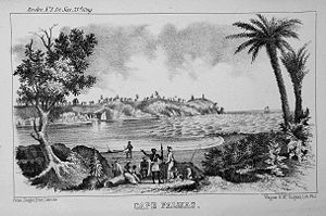
Cape Palmas
Encyclopedia
Liberia
Liberia , officially the Republic of Liberia, is a country in West Africa. It is bordered by Sierra Leone on the west, Guinea on the north and Côte d'Ivoire on the east. Liberia's coastline is composed of mostly mangrove forests while the more sparsely populated inland consists of forests that open...
, West Africa
West Africa
West Africa or Western Africa is the westernmost region of the African continent. Geopolitically, the UN definition of Western Africa includes the following 16 countries and an area of approximately 5 million square km:-Flags of West Africa:...
, at the extreme southwest corner of the northern half of the continent. The Cape
Headlands and bays
Headlands and bays are two related features of the coastal environment.- Geology and geography :Headlands and bays are often found on the same coastline. A bay is surrounded by land on three sides, whereas a headland is surrounded by water on three sides. Headlands are characterized by high,...
itself consists of a small, rocky peninsula
Peninsula
A peninsula is a piece of land that is bordered by water on three sides but connected to mainland. In many Germanic and Celtic languages and also in Baltic, Slavic and Hungarian, peninsulas are called "half-islands"....
connected to the mainland by a sandy isthmus
Isthmus
An isthmus is a narrow strip of land connecting two larger land areas usually with waterforms on either side.Canals are often built through isthmuses where they may be particularly advantageous to create a shortcut for marine transportation...
. Immediately to the west of the peninsula is the estuary
Estuary
An estuary is a partly enclosed coastal body of water with one or more rivers or streams flowing into it, and with a free connection to the open sea....
of the Hoffman River. Approximately 21 km (15 mi) further along the coast to the east, the Cavalla River
Cavalla River
The Cavalla River is a river in West Africa running from north of Mount Nimba in Guinea, through Côte d'Ivoire, to Zwedru in Liberia, and back to the border with Côte d'Ivoire. It ends in the Gulf of Guinea 21 km east of Harper, Liberia...
empties into the sea, marking the border between Liberia
Liberia
Liberia , officially the Republic of Liberia, is a country in West Africa. It is bordered by Sierra Leone on the west, Guinea on the north and Côte d'Ivoire on the east. Liberia's coastline is composed of mostly mangrove forests while the more sparsely populated inland consists of forests that open...
and the Côte d'Ivoire
Côte d'Ivoire
The Republic of Côte d'Ivoire or Ivory Coast is a country in West Africa. It has an area of , and borders the countries Liberia, Guinea, Mali, Burkina Faso and Ghana; its southern boundary is along the Gulf of Guinea. The country's population was 15,366,672 in 1998 and was estimated to be...
. It marks the western limit of the Gulf of Guinea
Gulf of Guinea
The Gulf of Guinea is the northeasternmost part of the tropical Atlantic Ocean between Cape Lopez in Gabon, north and west to Cape Palmas in Liberia. The intersection of the Equator and Prime Meridian is in the gulf....
, according to the International Hydrographic Organisation (IHO).
Approached from the sea, there are several landmarks at the cape. Offshore from the estuary of the Hoffman lies the small, oblong shape of Russwurm Island, which was named after the first black governor of Maryland In Africa (later Republic of Maryland
Republic of Maryland
The Republic of Maryland was a small African American nation which existed from 1854 to 1857, when it was united into what is now Liberia....
), John Brown Russwurm
John Brown Russwurm
John Brown Russwurm was an American abolitionist from Jamaica, known for his newspaper, Freedom's Journal. He moved from the United States to govern the Maryland section of an African American colony in Liberia, dying there in 1851....
. This island is connected to the peninsula by a breakwater
Breakwater (structure)
Breakwaters are structures constructed on coasts as part of coastal defence or to protect an anchorage from the effects of weather and longshore drift.-Purposes of breakwaters:...
. There is also a lighthouse
Lighthouse
A lighthouse is a tower, building, or other type of structure designed to emit light from a system of lamps and lenses or, in older times, from a fire, and used as an aid to navigation for maritime pilots at sea or on inland waterways....
warning of the numerous shoals in the surrounding sea area. Clearly visible from offshore is a white building with an enormous golden orb on the roof, this being the masonic
Freemasonry
Freemasonry is a fraternal organisation that arose from obscure origins in the late 16th to early 17th century. Freemasonry now exists in various forms all over the world, with a membership estimated at around six million, including approximately 150,000 under the jurisdictions of the Grand Lodge...
lodge hall located in the city of Harper, Liberia
Harper, Liberia
Harper, situated on Cape Palmas, is the capital of Maryland County in Liberia. It is a coastal town situated between the Atlantic Ocean and the Hoffman River. Harper is Liberia's 11th largest town, with a population of 17,837....
.
Origin of the name
In 1458 Prince Henry the Navigator of PortugalPortugal
Portugal , officially the Portuguese Republic is a country situated in southwestern Europe on the Iberian Peninsula. Portugal is the westernmost country of Europe, and is bordered by the Atlantic Ocean to the West and South and by Spain to the North and East. The Atlantic archipelagos of the...
sent his captain Diogo Gomes
Diogo Gomes
Diogo Gomes , was a Portuguese navigator, explorer and writer.Diogo Gomes was a servant and explorer of Portuguese prince Henry the Navigator. His memoirs were dictated late in his life to Martin Behaim...
(1440-1482) on a voyage of discovery, trade, and slaving that took him and his crew as far south down the coast of West Africa
West Africa
West Africa or Western Africa is the westernmost region of the African continent. Geopolitically, the UN definition of Western Africa includes the following 16 countries and an area of approximately 5 million square km:-Flags of West Africa:...
as the mouth of the cape and estuary, which marks the point where the direction of the coastline of West Africa ceases to have any southerly component, but turns definitively to the east, beginning the Gulf of Guinea
Gulf of Guinea
The Gulf of Guinea is the northeasternmost part of the tropical Atlantic Ocean between Cape Lopez in Gabon, north and west to Cape Palmas in Liberia. The intersection of the Equator and Prime Meridian is in the gulf....
. Gomes named this geographic feature Cabo das Palmas, i.e. "Cape of the Palms", which was later semi-Anglicized to Cape Palmas. The river was named Rio das Palmas, later to be called the Hoffman River. Interestingly, the name Cape Palmas (while Liberia
Liberia
Liberia , officially the Republic of Liberia, is a country in West Africa. It is bordered by Sierra Leone on the west, Guinea on the north and Côte d'Ivoire on the east. Liberia's coastline is composed of mostly mangrove forests while the more sparsely populated inland consists of forests that open...
was still known as the Malaguetta Coast in Europe) first appeared on various maps of Africa in Latin and later numerous European languages. The earliest map of Africa with the name Cape Palmas is Cantino planisphere
Cantino planisphere
The Cantino planisphere is the earliest surviving map showing Portuguese Discoveries in the east and west. It is named after Alberto Cantino, an agent for the Duke of Ferrara, who successfully smuggled it from Portugal to Italy in 1502...
completed in 1502.
History
In December 1831, the Maryland state legislature appropriated US$10,000 for 26 years to transport free blacks and ex-slaves from the United States to Africa, and the Maryland State Colonization Society was established for this purpose.Originally a branch of the American Colonization Society
American Colonization Society
The American Colonization Society , founded in 1816, was the primary vehicle to support the "return" of free African Americans to what was considered greater freedom in Africa. It helped to found the colony of Liberia in 1821–22 as a place for freedmen...
that founded Liberia in 1822, Maryland State Colonization Society decided to establish a new settlement of its own that could accommodate its emigrants and named it Maryland In Africa on February 12, 1834. With Cape Palmas at its center, the colony was granted statehood on February 2, 1841 and then independence on May 29, 1854. On March 18, 1857, the state of Maryland was annexed as a part of the Republic of Liberia, after signing an annexation treaty with the Republic of Liberia.
City of Harper
The city of Harper, LiberiaHarper, Liberia
Harper, situated on Cape Palmas, is the capital of Maryland County in Liberia. It is a coastal town situated between the Atlantic Ocean and the Hoffman River. Harper is Liberia's 11th largest town, with a population of 17,837....
(established 1835 by the Maryland State Colonization Society
Republic of Maryland
The Republic of Maryland was a small African American nation which existed from 1854 to 1857, when it was united into what is now Liberia....
) extends to the northeast inland along the estuary of the Hoffman, providing a small harbor; the Hoffman Station settlement is on the right bank. The name Cape Palmas is generalized to indicate the entire surrounding region of Maryland County
Maryland County
Maryland County is a county in the southeastern portion of the West African nation of Liberia. One of 15 counties that comprise the first-level of administrative division in the nation, it has two districts. Harper serves as the capital with the area of the county measuring...
. It is also frequently applied in the vernacular as being virtually synonymous with the county seat
County seat
A county seat is an administrative center, or seat of government, for a county or civil parish. The term is primarily used in the United States....
, Harper.