

California Valley, California
Encyclopedia
California Valley is an unincorporated community located in the eastern part of San Luis Obispo County
, California
, in the northern portion of the Carrizo Plain
.
 Located (all mileage is driving distances)
northwest of Los Angeles
west of Bakersfield east of San Luis Obispo east of Atascadero southeast of Paso Robles
northwest of Taft
) and to the east by a major earthquake fault, the San Andreas Fault
(part of the Temblor Range
). Immediately south of California Valley is Soda Lake
, which is part of the Carrizo Plain National Monument.
and seclusion. Farming, ranching, petroleum development, solar energy projects, and BLM work related to the Carrizo Plain are among current, recent and planned activities in the area.
passing through to the sacred site at Painted Rock
, but no permanent Indian settlement existed due to a lack of easily accessible water. California Valley was originally a Spanish
land grant
, the El Chicote Ranch, that was used for seasonal cattle
raising.
Local newspaper archives suggest that outlaw
s hid in California Valley from time to time up until the 1930s. The original Spanish land grant was parceled out in 1960 into over 7,200 2.5 acre (10,000 m2) sections by optimistic real estate developers. According to their own advertising fliers, these 1960 developers believed that the California State Water Project
might bring water to the area. After a more northerly route (closer to Highway 41
/46
) for the State Water Project was selected, many buyers lost heart, many properties were abandoned and the original developers went bankrupt. Several ranches and other developments built dirt or gravel airstrips and at least one paved
runway
was built and was at one time listed on aeronautical charts.
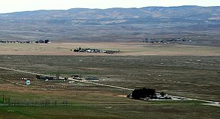
A few hundred people have built homes in this isolated area since, but the mass growth once promised never materialized. A Community Services District (CSD) was formed to deliver services to these residents, which includes trash collection, improvement of roads and the upkeep of a Community Center with a small public library
.
Between 1960 and 2000, a number of old cars and refuse were dumped in the California Valley area, much of it by local residents, posing serious environmental issues. In 2006, a combined effort by the California Highway Patrol
, California Department of Motor Vehicles
, San Luis Obispo County Code Enforcement, and local businesses worked together to remove abandoned vehicles and remove accumulated trash.
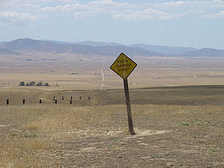
 California Valley is located on Soda Lake Road about two miles (3 km) south of State Route 58
. A small general store is currently closed, as is a previously popular small restaurant. The community is served by a school
and community center with library
, open only on Wednesdays. Other than State Route 58
and Bitterwater Road, access is mainly through the Carrizo Plain
via Soda Lake Road, which is a seasonal improved dirt road south of Soda Lake to State Route 33
/State Route 166
; or via smaller seasonal dirt roads to the east and south. No scheduled bus routes serve the community, and there are no rail lines.
Water, a porta-potty and a pay phone are available at the Community Center. The quality of the water is in dispute. Many California Valley residents consider the water potable, but signage to the contrary has been posted in the past.
Electricity
is available in parts of California Valley. Telephone
service is available through SBC. The local prefix is (805
) 475-XXXX. There is strong analog mobile phone
coverage and limited ("backscatter
") GSM mobile phone coverage, as well as limited Nextel coverage. Verizon Wireless does have a sole tower which overlooks and covers a good portion of the valley.
The local zip code
is 93453. Mail is delivered to drop boxes at the Community Center. Main roads (Belmont Trail, Soda Lake Road, Seven Mile Road) are paved to an extent. Others are packed dirt or Decomposed Granite. Other than the main roads, the only maintained roads are those with homes on them. Roads are frequently maintained only up to residential driveways.
Blue "No Services" signs are posted at major intersections leading into the California Valley area. No gas stations exist in the California Valley area. The nearest gasoline stations are in Taft/Maricopa, Atascadero/Santa Margarita, and on the outskirts of Paso Robles. This has led to stranded travelers on a number of occasions. Tow truck
service is available but may be delayed for several hours.
Law enforcement is provided by the County Sheriff
, but there is no local office or assigned unit. The California Highway Patrol
infrequently patrols Highway 58. No medical services (doctors, clinics, hospitals) are available in the California Valley area. Fire and rescue services are provided by San Luis Obispo County Fire Station #42 located at the Community Center. The Station is staffed Tuesday through Thursday. Helicopter
MEDEVAC
service from Santa Maria and Bakersfield
is available, weather permitting.
, built in 1953, with about 46 students in attendance. The few high school students are bused to Atascadero, California
, which had one of the last high school dormitories in California until the 1990s for their use. The nearest community college is in Taft
. The nearest four year university is Cal Poly, San Luis Obispo
.
operates the Carrizo Plain National Monument Guy L. Goodwin Education Center about 12 miles (19.3 km) south on Soda Lake Road during limited hours for several months of the year.
, which is an arid grassland. Only limited drinkable groundwater
is available. Nearby Soda Lake
is an alkali lake and undrinkable. "The future development of California Valley is anticipated to be limited by water availability" -- San Luis Obispo County General Plan. Alkaline soils hinder attempts at agricultural development. The Carrizo Plain National Monument, administered by the United States Bureau of Land Management, was established to protect elements of native history and the undeveloped ecology of the southern part of the valley.
es raise cattle
. Some of the empty residential-zoned lands are used for illegal sheep grazing
under contract with the Community Service District. Litigation brought upon the CSD by several residents resulted in the CSD banning grazing agreements and an undisclosed settlement amount. Other activities of interest in California Valley include an Indian sweat lodge
, hot air balloon
ing, bird-watching, and astronomy
, due to clear skies and no light pollution
. In particular, Highway 58 is a popular route for car
and motorcycle touring
enthusiasts due to very low traffic and winding roads.
With the recent surge (and equally sudden decline) in oil prices, along with state emphasis on development of renewable energy sources, solar energy firms have studied California Valley and adjacent areas for siting possible solar power generating facilities. As the area is one of the sunniest in the United States, and competition from other economically self-sustaining land uses has been minimal, several such facilities are already under consideration. Two solar plants capable of generating 800 megawatts of power, California Valley Solar Ranch (SunPower) and Topaz Solar Farms (OptiSolar) have already signed agreements with PG&E, the northern California electric utility, to provide power to the state grid; another smaller plant, by Ausra, would provide 177 megawatts. As of early 2009, construction is ready to begin on some of these facilities; the 800-megawatt plants would be the largest in the world.
San Luis Obispo County, California
San Luis Obispo County is a county located along the Pacific Ocean in the Central Coast of the U.S. state of California, between Los Angeles and the San Francisco Bay Area. As of the 2010 census its population was 269,637, up from 246,681 at the 2000 census...
, California
California
California is a state located on the West Coast of the United States. It is by far the most populous U.S. state, and the third-largest by land area...
, in the northern portion of the Carrizo Plain
Carrizo Plain
The Carrizo Plain is a large enclosed plain, approximately 50 miles long and up to 15 miles across, in southeastern San Luis Obispo County, California, about 100 miles northwest of Los Angeles, California...
.
northwest of Los Angeles
Los Angeles, California
Los Angeles , with a population at the 2010 United States Census of 3,792,621, is the most populous city in California, USA and the second most populous in the United States, after New York City. It has an area of , and is located in Southern California...
west of Bakersfield east of San Luis Obispo east of Atascadero southeast of Paso Robles
Paso Robles, California
Paso Robles is a city in San Luis Obispo County, California, United States. Paso Robles is the fastest growing city in San Luis Obispo County: Its population at the 2000 census was 24,297; in 2010 it recorded some 29,793 residentsLocated on the Salinas River north of San Luis Obispo, California,...
northwest of Taft
Taft, California
Taft is a city in the foothills at the extreme southwestern edge of the San Joaquin Valley, in Kern County, California. Taft is located west-southwest of Bakersfield, at an elevation of 955 feet . The population was 9,327 at the 2010 census...
Geography
California Valley is located at approximately 35.32° North, 120.01° West. The zoned area of the valley is 24,083 acres (97.5 square kilometers) and it is approximately 1,970 feet (600m) above sea level. The valley is very nearly flat, bordered to the west by mountains (part of the Los Padres National ForestLos Padres National Forest
Los Padres National Forest is a forest located in southern and central California, which includes most of the mountainous land along the California coast from Ventura to Monterey, extending inland...
) and to the east by a major earthquake fault, the San Andreas Fault
San Andreas Fault
The San Andreas Fault is a continental strike-slip fault that runs a length of roughly through California in the United States. The fault's motion is right-lateral strike-slip...
(part of the Temblor Range
Temblor Range
The Temblor Range is a mountain range within the California Coast Ranges, at the southwestern extremity of the San Joaquin Valley in California in the United States. It runs in a northwest-southeasterly direction along the borders of Kern County and San Luis Obispo County. The name of the range is...
). Immediately south of California Valley is Soda Lake
Soda Lake (San Luis Obispo County)
Soda Lake is a shallow, ephemeral, alkali endorheic lake in the Carrizo Plain in southeastern San Luis Obispo County, California. The lake is located on the southwest side of the northern Carrizo Plain, 103 km east of San Luis Obispo. It can be reached by Soda Lake Road, which runs...
, which is part of the Carrizo Plain National Monument.
Demographics
Fewer than 500 people live in California Valley. Residents are attracted to the area by its dry climateClimate
Climate encompasses the statistics of temperature, humidity, atmospheric pressure, wind, rainfall, atmospheric particle count and other meteorological elemental measurements in a given region over long periods...
and seclusion. Farming, ranching, petroleum development, solar energy projects, and BLM work related to the Carrizo Plain are among current, recent and planned activities in the area.
History
California Valley is believed to have been visited by Native AmericansNative Americans in the United States
Native Americans in the United States are the indigenous peoples in North America within the boundaries of the present-day continental United States, parts of Alaska, and the island state of Hawaii. They are composed of numerous, distinct tribes, states, and ethnic groups, many of which survive as...
passing through to the sacred site at Painted Rock
Painted Rock
Painted Rock is a smooth horseshoe-shaped marine sandstone rock formation with pictograph rock art about 250 feet across and 45 feet tall near Soda Lake within the Carrizo Plain National Monument on the southwest side of the northern Carrizo Plain, west of Bakersfield, California and about east...
, but no permanent Indian settlement existed due to a lack of easily accessible water. California Valley was originally a Spanish
Spain
Spain , officially the Kingdom of Spain languages]] under the European Charter for Regional or Minority Languages. In each of these, Spain's official name is as follows:;;;;;;), is a country and member state of the European Union located in southwestern Europe on the Iberian Peninsula...
land grant
Land grant
A land grant is a gift of real estate – land or its privileges – made by a government or other authority as a reward for services to an individual, especially in return for military service...
, the El Chicote Ranch, that was used for seasonal cattle
Cattle
Cattle are the most common type of large domesticated ungulates. They are a prominent modern member of the subfamily Bovinae, are the most widespread species of the genus Bos, and are most commonly classified collectively as Bos primigenius...
raising.
Local newspaper archives suggest that outlaw
Outlaw
In historical legal systems, an outlaw is declared as outside the protection of the law. In pre-modern societies, this takes the burden of active prosecution of a criminal from the authorities. Instead, the criminal is withdrawn all legal protection, so that anyone is legally empowered to persecute...
s hid in California Valley from time to time up until the 1930s. The original Spanish land grant was parceled out in 1960 into over 7,200 2.5 acre (10,000 m2) sections by optimistic real estate developers. According to their own advertising fliers, these 1960 developers believed that the California State Water Project
California State Water Project
The California State Water Project, commonly known as the SWP , is the world's largest publicly built and operated water and power development and conveyance system. The SWP was designed and is operated by the California Department of Water Resources...
might bring water to the area. After a more northerly route (closer to Highway 41
California State Route 41
State Route 41 is a state highway in the U.S. state of California, connecting the Cabrillo Highway in Morro Bay with Fresno and Yosemite National Park via the San Joaquin Valley. Except between US 101 in Atascadero and SR 46 near Shandon, SR 41 is part of the California Freeway and Expressway...
/46
California State Route 46
State Route 46 is an east–west state highway in the U.S. state of California. It is a major crossing of the Coast Ranges, connecting SR 1 on the Central Coast near Cambria and US 101 in Paso Robles with SR 99 at Famoso in the San Joaquin Valley. East of Paso Robles, where it carried U.S...
) for the State Water Project was selected, many buyers lost heart, many properties were abandoned and the original developers went bankrupt. Several ranches and other developments built dirt or gravel airstrips and at least one paved
Pavement (material)
Road surface or pavement is the durable surface material laid down on an area intended to sustain vehicular or foot traffic, such as a road or walkway. In the past cobblestones and granite setts were extensively used, but these surfaces have mostly been replaced by asphalt or concrete. Such...
runway
Runway
According to ICAO a runway is a "defined rectangular area on a land aerodrome prepared for the landing and take-off of aircraft." Runways may be a man-made surface or a natural surface .- Orientation and dimensions :Runways are named by a number between 01 and 36, which is generally one tenth...
was built and was at one time listed on aeronautical charts.
A few hundred people have built homes in this isolated area since, but the mass growth once promised never materialized. A Community Services District (CSD) was formed to deliver services to these residents, which includes trash collection, improvement of roads and the upkeep of a Community Center with a small public library
Library
In a traditional sense, a library is a large collection of books, and can refer to the place in which the collection is housed. Today, the term can refer to any collection, including digital sources, resources, and services...
.
Between 1960 and 2000, a number of old cars and refuse were dumped in the California Valley area, much of it by local residents, posing serious environmental issues. In 2006, a combined effort by the California Highway Patrol
California Highway Patrol
The California Highway Patrol is a law enforcement agency of the U.S. state of California. The CHP has patrol jurisdiction over all California highways and also acts as the state police....
, California Department of Motor Vehicles
California Department of Motor Vehicles
The California Department of Motor Vehicles is the state agency responsible for the registration of motor vehicles and boats and the issuance of driver's licenses in the U.S. state of California. It is responsible for regulating new car dealers , commercial cargo carriers, private driving...
, San Luis Obispo County Code Enforcement, and local businesses worked together to remove abandoned vehicles and remove accumulated trash.
Infrastructure
California State Route 58
State Route 58 is an east-west highway across the California Coast Ranges, the southern San Joaquin Valley, the Tehachapi Mountains, which border the southern Sierra Nevada, and the Mojave Desert. It runs between its western terminus near Santa Margarita and its eastern terminus at Barstow...
. A small general store is currently closed, as is a previously popular small restaurant. The community is served by a school
School
A school is an institution designed for the teaching of students under the direction of teachers. Most countries have systems of formal education, which is commonly compulsory. In these systems, students progress through a series of schools...
and community center with library
Library
In a traditional sense, a library is a large collection of books, and can refer to the place in which the collection is housed. Today, the term can refer to any collection, including digital sources, resources, and services...
, open only on Wednesdays. Other than State Route 58
California State Route 58
State Route 58 is an east-west highway across the California Coast Ranges, the southern San Joaquin Valley, the Tehachapi Mountains, which border the southern Sierra Nevada, and the Mojave Desert. It runs between its western terminus near Santa Margarita and its eastern terminus at Barstow...
and Bitterwater Road, access is mainly through the Carrizo Plain
Carrizo Plain
The Carrizo Plain is a large enclosed plain, approximately 50 miles long and up to 15 miles across, in southeastern San Luis Obispo County, California, about 100 miles northwest of Los Angeles, California...
via Soda Lake Road, which is a seasonal improved dirt road south of Soda Lake to State Route 33
California State Route 33
State Route 33 is a north–south state highway in the U.S. state of California. SR 33 replaced part of U.S. Route 399 in 1964 during the "great renumbering" of routes. In the unincorporated sections of Kern County it is known as the West Side Highway...
/State Route 166
California State Route 166
State Route 166 is a state highway in the U.S. state of California. It connects the Central Coast to the southern San Joaquin Valley....
; or via smaller seasonal dirt roads to the east and south. No scheduled bus routes serve the community, and there are no rail lines.
Private airport
The private and restricted California Valley Airport Class II-C 4200 ft (1,280.2 m) paved runway extends south from the community center but is not marked on current aeronautical charts and is painted at the south end with a white "X" indicating that it is closed although it can be used with advance permission.Services
Community services are provided by the California Valley Community Service District (CSD). This includes road maintenance and limited trash service. The Community Center includes a fire station, small library, and community assembly hall. The address is 13084 Soda Lake Road, on the south side of Soda Lake Road, approximately 2 miles (3.2 km) south of Highway 58, in the village of California Valley.Water, a porta-potty and a pay phone are available at the Community Center. The quality of the water is in dispute. Many California Valley residents consider the water potable, but signage to the contrary has been posted in the past.
Electricity
Electricity
Electricity is a general term encompassing a variety of phenomena resulting from the presence and flow of electric charge. These include many easily recognizable phenomena, such as lightning, static electricity, and the flow of electrical current in an electrical wire...
is available in parts of California Valley. Telephone
Telephone
The telephone , colloquially referred to as a phone, is a telecommunications device that transmits and receives sounds, usually the human voice. Telephones are a point-to-point communication system whose most basic function is to allow two people separated by large distances to talk to each other...
service is available through SBC. The local prefix is (805
Area code 805
North American area code 805 is a California telephone area code. Area code 805 includes most or all of the California counties of San Luis Obispo, Santa Barbara, and Ventura, plus southernmost portions of Monterey County....
) 475-XXXX. There is strong analog mobile phone
Mobile phone
A mobile phone is a device which can make and receive telephone calls over a radio link whilst moving around a wide geographic area. It does so by connecting to a cellular network provided by a mobile network operator...
coverage and limited ("backscatter
Backscatter
In physics, backscatter is the reflection of waves, particles, or signals back to the direction they came from. It is a diffuse reflection due to scattering, as opposed to specular reflection like a mirror...
") GSM mobile phone coverage, as well as limited Nextel coverage. Verizon Wireless does have a sole tower which overlooks and covers a good portion of the valley.
The local zip code
ZIP Code
ZIP codes are a system of postal codes used by the United States Postal Service since 1963. The term ZIP, an acronym for Zone Improvement Plan, is properly written in capital letters and was chosen to suggest that the mail travels more efficiently, and therefore more quickly, when senders use the...
is 93453. Mail is delivered to drop boxes at the Community Center. Main roads (Belmont Trail, Soda Lake Road, Seven Mile Road) are paved to an extent. Others are packed dirt or Decomposed Granite. Other than the main roads, the only maintained roads are those with homes on them. Roads are frequently maintained only up to residential driveways.
Blue "No Services" signs are posted at major intersections leading into the California Valley area. No gas stations exist in the California Valley area. The nearest gasoline stations are in Taft/Maricopa, Atascadero/Santa Margarita, and on the outskirts of Paso Robles. This has led to stranded travelers on a number of occasions. Tow truck
Tow truck
A tow truck is a vehicle used to transport motor vehicles to another location , or to recover vehicles which are no longer on a drivable surface.Towing services are generally provided by an emergency road service operator...
service is available but may be delayed for several hours.
Law enforcement is provided by the County Sheriff
Sheriff
A sheriff is in principle a legal official with responsibility for a county. In practice, the specific combination of legal, political, and ceremonial duties of a sheriff varies greatly from country to country....
, but there is no local office or assigned unit. The California Highway Patrol
California Highway Patrol
The California Highway Patrol is a law enforcement agency of the U.S. state of California. The CHP has patrol jurisdiction over all California highways and also acts as the state police....
infrequently patrols Highway 58. No medical services (doctors, clinics, hospitals) are available in the California Valley area. Fire and rescue services are provided by San Luis Obispo County Fire Station #42 located at the Community Center. The Station is staffed Tuesday through Thursday. Helicopter
Helicopter
A helicopter is a type of rotorcraft in which lift and thrust are supplied by one or more engine-driven rotors. This allows the helicopter to take off and land vertically, to hover, and to fly forwards, backwards, and laterally...
MEDEVAC
MEDEVAC
Medical evacuation, often termed Medevac or Medivac, is the timely and efficient movement and en route care provided by medical personnel to the wounded being evacuated from the battlefield or to injured patients being evacuated from the scene of an accident to receiving medical facilities using...
service from Santa Maria and Bakersfield
Bakersfield, California
Bakersfield is a city near the southern end of the San Joaquin Valley in Kern County, California. It is roughly equidistant between Fresno and Los Angeles, to the north and south respectively....
is available, weather permitting.
Schools
The local school is Carrisa Plains Elementary SchoolElementary school
An elementary school or primary school is an institution where children receive the first stage of compulsory education known as elementary or primary education. Elementary school is the preferred term in some countries, particularly those in North America, where the terms grade school and grammar...
, built in 1953, with about 46 students in attendance. The few high school students are bused to Atascadero, California
Atascadero, California
Atascadero is a city in San Luis Obispo County, California, about equidistant from San Francisco and Los Angeles on U-S Highway 101. Atascadero is farther inland than most other San Luis Obispo County cities, and as a result, usually experiences warmer, drier summers and cooler winters than...
, which had one of the last high school dormitories in California until the 1990s for their use. The nearest community college is in Taft
Taft, California
Taft is a city in the foothills at the extreme southwestern edge of the San Joaquin Valley, in Kern County, California. Taft is located west-southwest of Bakersfield, at an elevation of 955 feet . The population was 9,327 at the 2010 census...
. The nearest four year university is Cal Poly, San Luis Obispo
California Polytechnic State University
California Polytechnic State University, or Cal Poly, is a public university located in San Luis Obispo, California, United States. The university is one of two polytechnic campuses in the 23-member California State University system....
.
Nearby communities and services
The even smaller community of Simmler is about 3 miles (4.8 km) northeast along Highway 58. The Bureau of Land ManagementBureau of Land Management
The Bureau of Land Management is an agency within the United States Department of the Interior which administers America's public lands, totaling approximately , or one-eighth of the landmass of the country. The BLM also manages of subsurface mineral estate underlying federal, state and private...
operates the Carrizo Plain National Monument Guy L. Goodwin Education Center about 12 miles (19.3 km) south on Soda Lake Road during limited hours for several months of the year.
Natural resources and climate
California Valley is on the Carrizo PlainCarrizo Plain
The Carrizo Plain is a large enclosed plain, approximately 50 miles long and up to 15 miles across, in southeastern San Luis Obispo County, California, about 100 miles northwest of Los Angeles, California...
, which is an arid grassland. Only limited drinkable groundwater
Groundwater
Groundwater is water located beneath the ground surface in soil pore spaces and in the fractures of rock formations. A unit of rock or an unconsolidated deposit is called an aquifer when it can yield a usable quantity of water. The depth at which soil pore spaces or fractures and voids in rock...
is available. Nearby Soda Lake
Soda Lake (San Luis Obispo County)
Soda Lake is a shallow, ephemeral, alkali endorheic lake in the Carrizo Plain in southeastern San Luis Obispo County, California. The lake is located on the southwest side of the northern Carrizo Plain, 103 km east of San Luis Obispo. It can be reached by Soda Lake Road, which runs...
is an alkali lake and undrinkable. "The future development of California Valley is anticipated to be limited by water availability" -- San Luis Obispo County General Plan. Alkaline soils hinder attempts at agricultural development.
Industry and uses
Most residents are retirees or have other outside incomes. Neighboring ranchRanch
A ranch is an area of landscape, including various structures, given primarily to the practice of ranching, the practice of raising grazing livestock such as cattle or sheep for meat or wool. The word most often applies to livestock-raising operations in the western United States and Canada, though...
es raise cattle
Cattle
Cattle are the most common type of large domesticated ungulates. They are a prominent modern member of the subfamily Bovinae, are the most widespread species of the genus Bos, and are most commonly classified collectively as Bos primigenius...
. Some of the empty residential-zoned lands are used for illegal sheep grazing
Grazing
Grazing generally describes a type of feeding, in which a herbivore feeds on plants , and also on other multicellular autotrophs...
under contract with the Community Service District. Litigation brought upon the CSD by several residents resulted in the CSD banning grazing agreements and an undisclosed settlement amount. Other activities of interest in California Valley include an Indian sweat lodge
Sweat lodge
The sweat lodge is a ceremonial sauna and is an important event in some North American First Nations or Native American cultures...
, hot air balloon
Hot air balloon
The hot air balloon is the oldest successful human-carrying flight technology. It is in a class of aircraft known as balloon aircraft. On November 21, 1783, in Paris, France, the first untethered manned flight was made by Jean-François Pilâtre de Rozier and François Laurent d'Arlandes in a hot air...
ing, bird-watching, and astronomy
Astronomy
Astronomy is a natural science that deals with the study of celestial objects and phenomena that originate outside the atmosphere of Earth...
, due to clear skies and no light pollution
Light pollution
Light pollution, also known as photopollution or luminous pollution, is excessive or obtrusive artificial light.The International Dark-Sky Association defines light pollution as:...
. In particular, Highway 58 is a popular route for car
Čar
Čar is a village in the municipality of Bujanovac, Serbia. According to the 2002 census, the town has a population of 296 people.-References:...
and motorcycle touring
Sport touring
A Sport touring motorcycle is a type of motorcycle that blends the performance of a sport bike with the long-distance capabilities of a touring motorcycle, while providing comfort and relative safety to the rider....
enthusiasts due to very low traffic and winding roads.
With the recent surge (and equally sudden decline) in oil prices, along with state emphasis on development of renewable energy sources, solar energy firms have studied California Valley and adjacent areas for siting possible solar power generating facilities. As the area is one of the sunniest in the United States, and competition from other economically self-sustaining land uses has been minimal, several such facilities are already under consideration. Two solar plants capable of generating 800 megawatts of power, California Valley Solar Ranch (SunPower) and Topaz Solar Farms (OptiSolar) have already signed agreements with PG&E, the northern California electric utility, to provide power to the state grid; another smaller plant, by Ausra, would provide 177 megawatts. As of early 2009, construction is ready to begin on some of these facilities; the 800-megawatt plants would be the largest in the world.
External links
- Carrisa Plains School
- Shandon/Carrizo Area Plan, Land Use and Circulation Element, General Plan, County of San Luis Obispo
- Carrizo Plain National Monument
- California Valley zoning standards supplement
- SLO County Grand Jury investigation into California Valley CSD
- California Valley Community Services District
- Atascadero Chamber of Commerce page
- Airport Details mentioned in 2/08 letter to California Energy Commission regarding solar farm plan.
- California Valley Weather by Weather Underground
- Carrizo Plain Weather by MesoWest, University of Utah
- http://maps.google.com/maps?f=d&source=s_d&saddr=%2B35%C2%B0+5'+47.04%22,+-119%C2%B0+46'+22.08%22+(MesoWest+WX+sensor+site+CAZC1+at+2490'MSL,+about+20+miles+SE+of+CA+Valley)&daddr=California+Valley,+California+to:painted+rock,+carrizo+plain+to:35.189807,-119.863227+(Goodwin+Center)&geocode=&hl=en&mra=ls&sll=35.189733,-119.863527&sspn=0.002332,0.003138&ie=UTF8&t=h&z=11gMaps: MesoWest WX sensor site, about 20mi.SE of CA Valley]
- TopoZone USGS Map excerpt