
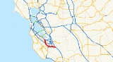
California State Route 85
Encyclopedia
Mountain View, California
-Downtown:Mountain View has a pedestrian-friendly downtown centered on Castro Street. The downtown area consists of the seven blocks of Castro Street from the Downtown Mountain View Station transit center in the north to the intersection with El Camino Real in the south...
and southern San Jose
San Jose, California
San Jose is the third-largest city in California, the tenth-largest in the U.S., and the county seat of Santa Clara County which is located at the southern end of San Francisco Bay...
. The entire freeway is named the West Valley Freeway. The majority of the route is also named the Norman Y. Mineta Highway, with the exception of the portion of Highway 85 passing through Saratoga which is named the CHP Officer Scott M. Greenly Memorial Freeway, named for a CHP
California Highway Patrol
The California Highway Patrol is a law enforcement agency of the U.S. state of California. The CHP has patrol jurisdiction over all California highways and also acts as the state police....
officer killed in the line of duty on that stretch of freeway. Highway 85 provides an alternative to U.S. Route 101, bypassing downtown San Jose and instead passing through Cupertino
Cupertino, California
Cupertino is an affluent suburban city in Santa Clara County, California in the U.S., directly west of San Jose on the western edge of the Santa Clara Valley with portions extending into the foothills of the Santa Cruz Mountains. The population was 58,302 at the time of the 2010 census. Forbes...
, Saratoga
Saratoga, California
Saratoga is a city in Santa Clara County, California, USA. It is located on the west side of the Santa Clara Valley, directly west of San Jose, in the San Francisco Bay area. The population was 29,926 at the 2010 census....
, Campbell
Campbell, California
Campbell is a city in Santa Clara County, California, a suburb of San Jose, and part of Silicon Valley, in the San Francisco Bay Area. As of the 2010 U.S. Census, Campbell's population is 39,349...
, Los Gatos
Los Gatos, California
The Town of Los Gatos is an incorporated town in Santa Clara County, California, United States. The population was 29,413 at the 2010 census. It is located in the San Francisco Bay Area at the southwest corner of San Jose in the foothills of the Santa Cruz Mountains...
, and San Jose's Cambrian Park
Cambrian Park, San Jose, California
Cambrian Park is a census-designated place and neighborhood of San Jose, a city in Santa Clara County, California, United States. Cambrian Park was never incorporated as a town , and there was never a Post Office for Cambrian Park...
, Almaden Valley
Almaden Valley, San Jose, California
Almaden Valley is an upper-class neighborhood of about 37,000 in the southwestern portion of San Jose, California, USA, roughly equivalent to the 95120 ZIP Code. The neighborhood is south east of the town of Los Gatos, west of the Santa Teresa neighborhood of San Jose and south of Coleman Ave...
, Blossom Valley
Blossom Valley, San Jose, California
Blossom Valley is a neighborhood in the southern region of San Jose, California northeast of the Los Capitancillos Ridge that separates it from Almaden Valley. It is located east of Cambrian and northeast of Almaden neighborhoods. It is just northeast of the Los Capitancillos Ridge and the Almaden...
and Santa Teresa
Santa Teresa, San Jose, California
Santa Teresa is a neighborhood in the south of San Jose, California, USA. It is east of Almaden Valley, surrounding Santa Teresa Boulevard, with access to Highway 85...
neighborhoods. The highway intersects with Interstate 280
Interstate 280 (California)
Interstate 280 is a 57-mile long north–south Interstate Highway in the San Francisco Bay Area of Northern California. It connects San Jose and San Francisco, running along just to the west of the cities of San Francisco Peninsula for most of its route.I-280 from its northern end at King...
, Highway 17, and Highway 87
California State Route 87
State Route 87 , locally called Highway 87 or the Guadalupe Freeway, is a north–south state highway entirely within San Jose, California, United States. Its name was changed from Guadalupe Parkway in 2004 after its entire constructed length was upgraded to a freeway...
. The total length of Highway 85 is 23.7 miles (38.1 km); the length of Highway 101 that it bypasses is 21.3 miles (34.3 km). The portion north of I-280 is also called the Stevens Creek Freeway.
The northern part of the freeway, 5.7 miles (9.2 km) from Stevens Creek Boulevard (near Interstate 280) north to Highway 101 through Mountain View, was built in the 1960s. The southern part, 18.5 miles (29.8 km) from 280 in Cupertino to 101 in south San Jose, remained unbuilt until the late 1980s and finally opened in 1994. Before the southern freeway portion was built from Stevens Creek Boulevard to the current southern terminus, the route's southern terminus was at State Route 9 in Saratoga. The 85 route numbering ran north along Saratoga-Sunnyvale Road in Saratoga and De Anza Boulevard in San Jose/Cupertino to Interstate 280
Interstate 280 (California)
Interstate 280 is a 57-mile long north–south Interstate Highway in the San Francisco Bay Area of Northern California. It connects San Jose and San Francisco, running along just to the west of the cities of San Francisco Peninsula for most of its route.I-280 from its northern end at King...
. The route number was then concurrent with Interstate 280
Interstate 280 (California)
Interstate 280 is a 57-mile long north–south Interstate Highway in the San Francisco Bay Area of Northern California. It connects San Jose and San Francisco, running along just to the west of the cities of San Francisco Peninsula for most of its route.I-280 from its northern end at King...
north to that highway's junction with the freeway portion of Route 85.
Route description
This route is part of the California Freeway and Expressway SystemCalifornia Freeway and Expressway System
The California Freeway and Expressway System is a system of existing or planned freeways and expressways in the U.S. state of California. It is defined by the Streets and Highways Code.-List of roads in the system:*State Route 1 *State Route 2...
. SR 85 has carpool lanes for its entire length.
SR 85 begins at an interchange with US 101 and heads due west through San Jose
San Jose, California
San Jose is the third-largest city in California, the tenth-largest in the U.S., and the county seat of Santa Clara County which is located at the southern end of San Francisco Bay...
. Near the Westfield mall in San Jose, SR 85 has an interchange with the southern terminus of the SR 87 freeway. SR 85 continues west into Los Gatos
Los Gatos, California
The Town of Los Gatos is an incorporated town in Santa Clara County, California, United States. The population was 29,413 at the 2010 census. It is located in the San Francisco Bay Area at the southwest corner of San Jose in the foothills of the Santa Cruz Mountains...
, where it intersects the SR 17 freeway. SR 85 briefly enters Campbell
Campbell, California
Campbell is a city in Santa Clara County, California, a suburb of San Jose, and part of Silicon Valley, in the San Francisco Bay Area. As of the 2010 U.S. Census, Campbell's population is 39,349...
and reenters San Jose before crossing into Saratoga
Saratoga, California
Saratoga is a city in Santa Clara County, California, USA. It is located on the west side of the Santa Clara Valley, directly west of San Jose, in the San Francisco Bay area. The population was 29,926 at the 2010 census....
. SR 85 turns northwest and briefly reenters San Jose before entering Cupertino
Cupertino, California
Cupertino is an affluent suburban city in Santa Clara County, California in the U.S., directly west of San Jose on the western edge of the Santa Clara Valley with portions extending into the foothills of the Santa Cruz Mountains. The population was 58,302 at the time of the 2010 census. Forbes...
and passing right next to De Anza College
De Anza College
De Anza College is a community college located in Cupertino, California. It was founded in 1967 on the site of the Beaulieu Winery and is named after the Spanish explorer Juan Bautista de Anza...
. SR 85 then interchanges with I-280 before briefly entering Sunnyvale
Sunnyvale, California
Sunnyvale is a city in Santa Clara County, California, United States. It is one of the major cities that make up the Silicon Valley located in the San Francisco Bay Area...
and Los Altos
Los Altos, California
Los Altos is a city at the southern end of the San Francisco Peninsula, in the San Francisco Bay Area. The city is in Santa Clara County, California, United States. The population was 28,976 according to the 2010 census....
and then entering Mountain View
Mountain View, California
-Downtown:Mountain View has a pedestrian-friendly downtown centered on Castro Street. The downtown area consists of the seven blocks of Castro Street from the Downtown Mountain View Station transit center in the north to the intersection with El Camino Real in the south...
, where it first intersects SR 237 before terminating at US 101 near the Ames Research Center.
Although SR 85 mainly passes through suburban Bay Area
San Francisco Bay Area
The San Francisco Bay Area, commonly known as the Bay Area, is a populated region that surrounds the San Francisco and San Pablo estuaries in Northern California. The region encompasses metropolitan areas of San Francisco, Oakland, and San Jose, along with smaller urban and rural areas...
cities, it does have several points of interest. The northern terminus is located near Moffett Field
Moffett Federal Airfield
Moffett Federal Airfield , also known as Moffett Field, is a joint civil-military airport located between northern Mountain View and northern Sunnyvale, California, USA. The airport is near the south end of San Francisco Bay, northwest of San Jose. Formerly a United States Navy facility, the former...
, with its huge Hangar 1. Microsoft's
Microsoft
Microsoft Corporation is an American public multinational corporation headquartered in Redmond, Washington, USA that develops, manufactures, licenses, and supports a wide range of products and services predominantly related to computing through its various product divisions...
Silicon Valley Campus is located at the northern end of the freeway. Near the interchange
Interchange (road)
In the field of road transport, an interchange is a road junction that typically uses grade separation, and one or more ramps, to permit traffic on at least one highway to pass through the junction without directly crossing any other traffic stream. It differs from a standard intersection, at which...
with Interstate 280
Interstate 280 (California)
Interstate 280 is a 57-mile long north–south Interstate Highway in the San Francisco Bay Area of Northern California. It connects San Jose and San Francisco, running along just to the west of the cities of San Francisco Peninsula for most of its route.I-280 from its northern end at King...
, SR 85 runs close to the headquarters of Apple Computer
Apple Computer
Apple Inc. is an American multinational corporation that designs and markets consumer electronics, computer software, and personal computers. The company's best-known hardware products include the Macintosh line of computers, the iPod, the iPhone and the iPad...
and next to De Anza College
De Anza College
De Anza College is a community college located in Cupertino, California. It was founded in 1967 on the site of the Beaulieu Winery and is named after the Spanish explorer Juan Bautista de Anza...
as well as the titled West Valley College
West Valley College
West Valley College is a community college in northern California. Founded in 1963, the campus is located on in the city of Saratoga. One of the distinguishing features of the school's location is that it is located right off of the West Valley Freeway....
, both community college
Community college
A community college is a type of educational institution. The term can have different meanings in different countries.-Australia:Community colleges carry on the tradition of adult education, which was established in Australia around mid 19th century when evening classes were held to help adults...
s in the area. VTA light rail runs in the median of SR 85 between the 85-87 interchange & the southern terminus.
Preserving the right-of-way
Land was set aside for the entire freeway in the 1950s, with maps first showing the proposed freeway in 1957. At the time, Santa Clara CountySanta Clara County, California
Santa Clara County is a county located at the southern end of the San Francisco Bay Area in the U.S. state of California. As of 2010 it had a population of 1,781,642. The county seat is San Jose. The highly urbanized Santa Clara Valley within Santa Clara County is also known as Silicon Valley...
still consisted largely of orchard
Orchard
An orchard is an intentional planting of trees or shrubs that is maintained for food production. Orchards comprise fruit or nut-producing trees which are grown for commercial production. Orchards are also sometimes a feature of large gardens, where they serve an aesthetic as well as a productive...
s, and so the right-of-way touched very few existing structures. During Governor Jerry Brown
Jerry Brown
Edmund Gerald "Jerry" Brown, Jr. is an American politician. Brown served as the 34th Governor of California , and is currently serving as the 39th California Governor...
's tenure in the 1970s, the building of highways was de-emphasized in favor of mass transit, and some building was allowed on the right-of-way with the expectation that the freeway would never be built. Local government officials, however, fought to preserve the right-of-way and succeeded in doing so. As a result, when congestion on other freeways—Interstate 280
Interstate 280 (California)
Interstate 280 is a 57-mile long north–south Interstate Highway in the San Francisco Bay Area of Northern California. It connects San Jose and San Francisco, running along just to the west of the cities of San Francisco Peninsula for most of its route.I-280 from its northern end at King...
, US 101, and Highway 17—intersecting this path became overwhelming, it was still possible for this freeway to be built with little demolition required.
In the interim, parts of the unused open space were leased for use without permanent structures, including a large tree nursery
Nursery (horticulture)
A nursery is a place where plants are propagated and grown to usable size. They include retail nurseries which sell to the general public, wholesale nurseries which sell only to businesses such as other nurseries and to commercial gardeners, and private nurseries which supply the needs of...
, a driving range, and among other things, overflow parking for De Anza College
De Anza College
De Anza College is a community college located in Cupertino, California. It was founded in 1967 on the site of the Beaulieu Winery and is named after the Spanish explorer Juan Bautista de Anza...
.
Funding and planning
The town of Los Gatos and city of Saratoga added to the complexity and cost of the planning and implementation; to avoid excessive noise, they insisted that the freeway be built below grade (at an eventual additional cost of US$60 million), that it have only three lanes in each direction: the leftmost lane being a HOV lane, and two lanes carrying standard traffic; furthermore, no truckTruck
A truck or lorry is a motor vehicle designed to transport cargo. Trucks vary greatly in size, power, and configuration, with the smallest being mechanically similar to an automobile...
s over 4.5 tons (4.0 metric tons) be allowed on the road. In addition, to prevent what they felt would be excessive additional traffic on their surface streets, they lobbied heavily to prevent having any freeway entrances or exits in their cities. Full interchanges were originally planned at Winchester Boulevard, Quito Road, Saratoga Avenue, and Prospect Road; the final compromise placed only a half interchange at Winchester and completely did away with the Quito and Prospect interchanges. As a result, backups at entrances to the freeway near these cities are tremendous during morning rush hour
Rush hour
A rush hour or peak hour is a part of the day during which traffic congestion on roads and crowding on public transport is at its highest. Normally, this happens twice a day—once in the morning and once in the evening, the times during when the most people commute...
, and Los Gatos and Campbell residents who want to take 85 southward must go two or three miles (3 to 5 km) out of their way to find a ramp onto the freeway.
The project was the first in the state for which county residents voted to tax themselves to build a state highway. Because state funds were scarce and congestion on other freeways and on surrounding surface streets was tremendous, a slight majority of voters (56%) voted for the tax in 1984. At the time, there was considerable controversy over whether funds would be better spent on mass transit and whether a freeway through so many residential areas would destroy the quality of life. The total US$785 million cost of the freeway was mostly funded by the special tax on county residents, along with matching state and federal funds. The project proved successful enough that, since then, many other locales have used local taxes to build state projects. It was also so effective as a solution to traffic problems that, several years after it was built, a poll by the Silicon Valley Manufacturing Group revealed that nearly 80% of voters claimed that they had voted for the tax.
Construction of the freeway
The northern section, from I-280 to U.S. 101 at Mountain View, was completed between 1965 and 1967 as four lanes (two in each direction). The northern section's carpool lanes were completed in 1990 (south half) and 1998 (north half). In the southern section, partial fill for the interchanges at Blossom Hill Road and Highway 87 was placed in 1986. Construction of the first structures (at the Highway 85/87 and Highway 85/Stevens Creek interchanges) began in approximately 1987-1988. Highway 85 opened between Santa Teresa Boulevard (at the future 85/87 interchange) and Cottle Road in 1991, along with the light rail line in the median of Highway 85. The extensions to Almaden Expressway and Great Oaks Boulevard were completed in 1992. With the completion of the southern leg (from I-280 to 85) of Highway 87 in 1993, the 85/87 interchange opened to traffic that year (with only two connector ramps, from 85 north to 87 north and 87 south to 85 south, due to funding limitations). The remaining segments, from Highway 101 (in South San Jose) to Great Oaks and from Almaden Expressway to I-280, opened in 1994. The projects completed in the 1990s had a total cost of about $785 million.The remaining ramps at the Highway 85/87 interchange (from 85 south to 87 north and 87 south to 85 north) were completed in 2003. At the southern Highway 85/101 interchange in South San Jose, carpool-to-carpool ramps and the south 101 to north 85 connector ramp were opened in 2004. The $125 million reconstruction of the northern Highway 85/101 interchange in Mountain View, with the original ramps (built circa 1965) replaced and new carpool-to-carpool and other ramps added, was completed in 2006. The projects completed in the 2000s had a total cost of about $237 million. There is still one missing connector in the Highway 85 system left to the future—the flyover ramp from 85 south to 101 north at the southern interchange, with no funding identified yet and which is not specifically listed in the Transportation 2030 plan by the Metropolitan Transportation Commission (San Francisco Bay Area)
Metropolitan Transportation Commission (San Francisco Bay Area)
The Metropolitan Transportation Commission is a regional planning, financing, and funding government agency in the San Francisco Bay Area. It was created in 1970 to coordinate the transit systems in the area's nine counties...
(MTC).
Significant future Highway 85 projects listed in MTC's Transportation 2030 plan, as of 2006 (in 2004 dollars), include:
(1) Route 85 northbound and southbound auxiliary lanes between Homestead Avenue and Fremont Avenue, at $19 million;
(2) Route 85 corridor improvements at $177 million;
(3) Route 85 northbound to Route 237 eastbound connector ramp improvements, at $22 million;
and (4) Route 237 westbound to Route 85 southbound connector ramp improvements, at $18 million.
The results
In October 1994, the completed freeway between Almaden Expressway and I-280 opened with a single day on which only pedestrians and bicyclists were allowed to travel its length. The evening before opening day several cities along the route including Saratoga and Campbell held street fair events on the freeway featuring fine food, wine, and games. Limo service was offered linking the different city's fairs giving locals their first glimpse of the new freeway. The next morning 85 was officially opened to traffic. The city of Campbell had planted a large display of pansiesPansy
The Pansy is a large group of hybrid plants cultivated as garden flowers. Pansies are derived from Viola species Viola tricolor hybridized with other viola species, these hybrids are referred to as Viola × wittrockiana or less commonly Viola tricolor hortensis...
spelling out the city's name on the sloped side of the freeway bed; this caused a traffic jam as motorists slowed to read the message. The flowers were removed after the first day.
The overall commute for people from south San Jose through Campbell into Mountain View and other business areas of Silicon Valley
Silicon Valley
Silicon Valley is a term which refers to the southern part of the San Francisco Bay Area in Northern California in the United States. The region is home to many of the world's largest technology corporations...
improved by roughly half an hour over previous longer routes on already crowded freeways or over miles of surface streets. Major surface streets that had once been unnavigable during many hours of the day suddenly became—and remained—usable. For example, eastern Blossom Hill Road had a typical load of 23,000 cars a day before 85 opened; as of 2004, a typical day's load was a mere 11,000 cars. (Conversely, Saratoga Avenue, which previously had been a fairly quiet road, now sees about 18,000 cars a day because it is the only interchange in or near the city of Saratoga.)
As with any freeway, ambient noise in surrounding neighborhoods increased, from a steadily annoying whisper of sound day and night to a dull roar that muted backyard conversations. Property values, however, did not diminish; it is possible that the improved commute and access to the vast California freeway network improved the desirability of these neighborhoods. The noise level however has continued to be an issue with some residents, particularly in Saratoga. Caltrans has floated several options from repaving with asphalt, to grinding down the current concrete surface of the highway. An experimental length of the freeway from Cox Avenue to De Anza Boulevard was ground down in 2003. This smoothed out much of the top layer of the freeway removing most of the rain grooves that had been cut in the concrete when the highway was first built. The result did lower the ambient sound levels along that stretch of the freeway, and subsequently the entire concrete surfaced section of the freeway from Almaden Expressway to Stevens Creek Boulevard was microgrooved in a follow up project in 2005.
Other Unique features and events
Besides the funding breakthrough, SR 85 set new standards in two additional areas: metering lights and median safety barriers.Route 85 was the first freeway in California
California
California is a state located on the West Coast of the United States. It is by far the most populous U.S. state, and the third-largest by land area...
to open with metering lights at every onramp, including interchanges with Routes 17 and 101. When the freeway opened on October 19, 1994, the lights caused tremendous backups at the onramps during commute hours, raising an outcry from commuters furious at having to wait as much as 20 to 30 minutes in the worst cases before entering the freeway. The county required Caltrans to turn off the metering lights, which they did on November 17, 1994. This almost immediately slowed the commute over the full 24 mile (39 km) stretch by 33 minutes; Caltrans eventually turned the lights back on in 1995, which sped up the overall commute considerably.
In January 2009, several metering lights in the southern portion of SR 85 were reactivated. These included the Route 87-to-Route 85 interchange, the Almaden Expressway on-ramps, and the Blossom Hill Road on-ramps.
The freeway was constructed with a 46-to-50-foot (14–15 m) wide center median with the intention that a light rail
Light rail
Light rail or light rail transit is a form of urban rail public transportation that generally has a lower capacity and lower speed than heavy rail and metro systems, but higher capacity and higher speed than traditional street-running tram systems...
extension could be built. Initially, no barrier of any kind was installed in the median because, at the time, Caltrans regulations stated that any median wider than 45 feet (14 m) did not require a median barrier unless there was a history of head-on collision
Head-on collision
A head-on collision is one where the front ends of two ships, trains, planes or vehicles hit each other, as opposed to a side collision or rear-end collision.-Rail transport:...
s. However, within the first year, one person died, and in a one-year period from 1996 to 1997 six more were killed in head-on collisions by cars crossing the median at high speeds. Public outcry convinced Caltrans to install the standard post-and-metal-beam barrier the entire length of the freeway and also to change their regulations so that median barriers are now required on all high-volume freeways with medians of less than 75 feet (23 m). Accidents and injuries dropped by roughly one third in the first year after the barrier was installed.
SR 85 has the distinction of being one of only a handful of California freeways that do not allow tractor semis over 4.5 tons (4.0 metric tons) to utilize it. This restriction is in effect from U.S. Route 101 in the south to Stevens Creek Boulevard in the north. This has been a prime factor in reducing the level of noise that the freeway would otherwise produce as most large trucks are unable to use the freeway.
In 1998, California Highway Patrol
California Highway Patrol
The California Highway Patrol is a law enforcement agency of the U.S. state of California. The CHP has patrol jurisdiction over all California highways and also acts as the state police....
officer Scott Greenly was struck by a car and killed while issuing a ticket on the shoulder of Route 85; thereafter the portion between Quito Road and Prospect Road in the City of Saratoga was named the CHP Officer Scott M. Greenly Memorial Freeway. On September 15, 2008, the remainder of the freeway, north of Prospect Road as well as south of Quito Road, was named in honor of former San Jose mayor, congressman, and United States Secretary of Transportation Norman Mineta
Norman Mineta
Norman Yoshio Mineta, is a United States politician of the Democratic Party. Mineta most recently served in President George W. Bush's Cabinet as the United States Secretary of Transportation, the only Democratic Cabinet Secretary in the Bush administration...
.
Exit list
- Note: Except where prefixed with a letter, postmiles were measured in 1964, based on the alignment as it existed at that time, and do not necessarily reflect current mileage.
The entire route is in Santa Clara County
Santa Clara County, California
Santa Clara County is a county located at the southern end of the San Francisco Bay Area in the U.S. state of California. As of 2010 it had a population of 1,781,642. The county seat is San Jose. The highly urbanized Santa Clara Valley within Santa Clara County is also known as Silicon Valley...
.
{| class=wikitable
!Location
!Postmile
!Exit
Exit number
An exit number is a number assigned to a road junction, usually an exit from a freeway. It is usually marked on the same sign as the destinations of the exit, as well as a sign in the gore....
!Destinations
!Notes
|-
|rowspan=10|San Jose
San Jose, California
San Jose is the third-largest city in California, the tenth-largest in the U.S., and the county seat of Santa Clara County which is located at the southern end of San Francisco Bay...
|0.00
|1A
|
|Southbound exit and northbound entrance
|-
|0.18
|1B
|
.svg.png)
San Francisco, California
San Francisco , officially the City and County of San Francisco, is the financial, cultural, and transportation center of the San Francisco Bay Area, a region of 7.15 million people which includes San Jose and Oakland...
|Southbound exit and northbound entrance
|-bgcolor=#ffdddd
|0.79
|1C
|Great Oaks Boulevard
|Southbound exit and northbound entrance
|-
|1.97
|2
|Cottle Road
|
|-
|3.93
|4
|Blossom Hill Road (CR G10)
|
|-
|5.22
|5A
|
|Signed as exit 5B southbound
|-
|5.22
|5B
|Santa Teresa Boulevard
|Signed as exit 5A southbound
|-
|6.14
|6
|Almaden Expressway (CR G8)
|
|-
|8.11
|8
|Camden Avenue
|
|-
|9.28
|9
|Union Avenue
|
|-
|rowspan=3|Los Gatos
Los Gatos, California
The Town of Los Gatos is an incorporated town in Santa Clara County, California, United States. The population was 29,413 at the 2010 census. It is located in the San Francisco Bay Area at the southwest corner of San Jose in the foothills of the Santa Cruz Mountains...
|R10.23
|10
|Bascom Avenue, Los Gatos Boulevard
|
|-
|R10.50
|11A
|
|Signed as exit 11 northbound
|-bgcolor=#ffdddd
|R11.00
|11B
|Winchester Boulevard
|Southbound exit and northbound entrance
|-
|Saratoga
Saratoga, California
Saratoga is a city in Santa Clara County, California, USA. It is located on the west side of the Santa Clara Valley, directly west of San Jose, in the San Francisco Bay area. The population was 29,926 at the 2010 census....
|R13.68
|14
|Saratoga Avenue
|
|-
|San Jose
San Jose, California
San Jose is the third-largest city in California, the tenth-largest in the U.S., and the county seat of Santa Clara County which is located at the southern end of San Francisco Bay...
|R15.87
|16
|De Anza Boulevard
|Former SR 85
|-
|rowspan=3|Cupertino
Cupertino, California
Cupertino is an affluent suburban city in Santa Clara County, California in the U.S., directly west of San Jose on the western edge of the Santa Clara Valley with portions extending into the foothills of the Santa Cruz Mountains. The population was 58,302 at the time of the 2010 census. Forbes...
|R17.70
|18
|Stevens Creek Boulevard
|Southbound trucks over 9,000 lbs. must exit
|-
|R18.45
|19A
|
|Signed as exit 19 northbound
|-bgcolor=#ffdddd
|R18.86
|19B
|Homestead Road
|Southbound exit and northbound entrance
|-
|Sunnyvale
Sunnyvale, California
Sunnyvale is a city in Santa Clara County, California, United States. It is one of the major cities that make up the Silicon Valley located in the San Francisco Bay Area...
|R19.86
|20
|Fremont Avenue – Los Altos
Los Altos, California
Los Altos is a city at the southern end of the San Francisco Peninsula, in the San Francisco Bay Area. The city is in Santa Clara County, California, United States. The population was 28,976 according to the 2010 census....
|
|-
|rowspan=7|Mountain View
Mountain View, California
-Downtown:Mountain View has a pedestrian-friendly downtown centered on Castro Street. The downtown area consists of the seven blocks of Castro Street from the Downtown Mountain View Station transit center in the north to the intersection with El Camino Real in the south...
|R21.75
|22
|
|Signed as exits 22A (south) and 22B (north)
|-bgcolor=#ffdddd
|R22.16
|22C
|
|Northbound exit and southbound entrance
|-bgcolor=#ffdddd
|R22.63
|23
|Evelyn Avenue
|Northbound exit and southbound entrance
|-bgcolor=#ffdddd
|R22.63
|23
|Central Expressway (CR G6)
|Southbound exit and northbound entrance
|-bgcolor=#ffdddd
|R23.44
|24A
|Moffett Boulevard
|Northbound exit and southbound entrance
|-bgcolor=#ffdddd
|R23.87
|24B
|
|Northbound exit and southbound entrance
|-bgcolor=#ffdddd
|R23.87
|24C
|Shoreline Boulevard
|Northbound exit and southbound entrance