
Brockway Mountain Drive
Encyclopedia
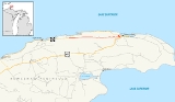
Brockway Mountain Drive is a 8.883 miles (14.3 km) scenic highway just west of Copper Harbor
in the Upper Peninsula of Michigan
in the United States. Drivers can access the road from state highway M-26
on either end near Eagle Harbor to the west or Copper Harbor to the east in the Keweenaw Peninsula
. The drive runs along the ridge of Brockway Mountain on the Keweenaw Fault
and climbs to 1320 feet (402 m) above sea level, 720 feet (219.5 m) above the surface of Lake Superior
. Several viewpoints along the route allow for panoramas of Copper Harbor, Lake Superior, and undeveloped woodland. On a clear day, Isle Royale
is visible approximately 50 miles (80.5 km) in distance from the top of the mountain.
Brockway Mountain was named for David D. Brockway, one of the pioneer residents of the area. The road was constructed by the county road commission, the Works Project Administration (WPA) and the Civilian Conservation Corps
(CCC) in 1933. It was briefly used as a connection for the parallel state highway after it opened. Since it opened, Brockway Mountain Drive has been recognized nationally and locally in several media outlets for its picturesque qualities, usually in profiles of Keweenaw County
, the Upper Peninsula or other scenic drives.
Upon reaching the top of the mountain, drivers are greeted with a full panoramic view of the surrounding area, allowing views of Lake Superior, Copper Harbor, Eagle Harbor and the surrounding lakes and forests. Freighters occasionally can be seen traversing Lake Superior, and on clear days Isle Royale
can be spotted nearly 50 miles (80.5 km) in the distance. Also on the top of the mountain is the Skytop Inn. Founded in 1933, the Skytop Inn offers a selection of books and collectibles. It was originally housed in a log cabin.
Continuing eastward, the drive descends down the mountain toward Copper Harbor. The roadway twists and turns as it alternately climbs and descends several smaller hills along the ridgeline. Along the drive, several viewpoints provide the opportunity to pull off and take in the surroundings. A few of them lie directly adjacent to the face of the bluff where the mountain quickly rises from the surrounding land. Near the eastern end, there are two sharp hairpin turn
s, the first of which has a scenic overlook and parking area. This spot overlooks Copper Harbor and the nearby Copper Country Trail National Scenic Byway portion of US Highway 41
(US 41) just to the east. From here, the road makes its steep descent down from the ridge, through the second turn and ends at M-26 on the western edge of town.
This road is one of the highest scenic roadways above sea level in the US between the Rocky
and Allegheny
mountains. During the winter months, Brockway Mountain Drive is closed to cars as the Keweenaw County Road Commission does not plow the road; instead the drive is used as a snowmobile trail. According to the commission, 200 vehicles per day use the roadway on average.
of Michigan about 5 miles (8 km) west of Copper Harbor. The top of the mountain is 720 feet (219.5 m) above the level of Lake Superior. The peak was named for Daniel D. Brockway, local pioneer settler, postmaster and state road commissioner. Brockway moved to Copper Harbor in 1846 at the beginning of the area's copper boom. He built the first permanent structure in the community, a hostelry named The Brockway House, which was used by the miners and scientists in the area. By the time of his death on May 9, 1899, the ridge west of town had been named in his honor.
Construction of Brockway Mountain Drive began in early 1933 by the Keweenaw County Road Commission with federal highway funding designed to provide meaningful work to the many copper miners who became unemployed during the Great Depression
. Rather than provide welfare, the government provided work for the jobless. The WPA and the CCC were the agencies on the federal level responsible for the project. Up to 300 laborers were employed for a wage of 25¢
/hr (equivalent to $/hr in ). The work required to build the road was carried out by manual labor, with the assistance of a team of horses, in a project designed to maximize the numbers of men employed. The road was opened for public use that October at a cost of $30,000. The following year in 1934, additional work was completed to "touch up" the roadway, and it was paved in 1938. In the interim, the road was temporarily used as a connection between completed segments of the parallel state highway, numbered M-129
at the time. This highway, now part of M-26, was built starting in July 1933 but was not completed through the area until October 1934. According to historian LeRoy Barnett, "this county highway quickly became one of the most popular motoring destinations in the Midwest."
with strong winds, and guide books advise visitors to bring windbreaker jackets, even in the summer. The peak is also known as an excellent star-gazing location because there are no electric lights to interrupt the darkness. The surrounding mountainsides are privately owned, mostly by Champion International Paper
. The company receives reduced taxes in exchange for keeping the land open for recreational uses. The Michigan Nature Association
owns 200 acres (80.9 ha) of property on Brockway Mountain itself. There are over 700 species of flowers including trillium
and orchids. The peak bloom is in June, and some of the wildflowers on display are not found elsewhere in the state. Motorcycle Cruiser magazine featured a piece on Copper Harbor in February 2010 that suggested visiting Brockway Mountain at dawn saying that "the vista at the peak is amazing and it's worth the early morning rise." The area is renowned as a fall foliage destination; color season starts by the second week of September and ends in October.
had similar praise in 1962, saying "a side trip that should not be missed is the Brockway Mountain Drive ... for a panoramic view of the forest and the blue waters of Lake Superior." The Chicago Tribune
called the overlook "breathtaking" in 1986. The Pioneer Press
of St. Paul profiled the area in 2005 saying, "and there are tourists, of course. They ... cruise along Brockway Mountain Drive, renowned for fall color."
In April 1994 and April 2001, the route along US 41 and Brockway Mountain Drive was selected as "one of the best fall color views and mountain biking areas" by Michigan Living. It was also named the "most beautiful bike ride in the United States" by Bicycling
magazine in February 1995. The Star Tribune
in Minneapolis said that a visit to the drive "is worth the whole trip by itself, with a twisting road leading up to the crest, with panoramic views of fall colors."
The drive was also included in the coverage of the Copper Country Trail, a designation applied to the neighboring US 41 by the Federal Highway Administration
as a part of the National Scenic Byway
program. NBC
's Today featured Brockway Mountain Drive in September 2007 as part of a segment on "great and unusual fall foliage destinations". In May 2010, local residents of the Upper Peninsula chose the road as the region's "favorite natural wonder" in a poll conducted by WLUC-TV
.
Copper Harbor, Michigan
Copper Harbor is a small unincorporated community in northeastern Keweenaw County in the U.S. state of Michigan. It is within Grant Township on the Keweenaw Peninsula that juts from the Upper Peninsula of Michigan into Lake Superior.-History:...
in the Upper Peninsula of Michigan
Upper Peninsula of Michigan
The Upper Peninsula of Michigan is the northern of the two major land masses that make up the U.S. state of Michigan. It is commonly referred to as the Upper Peninsula, the U.P., or Upper Michigan. It is also known as the land "above the Bridge" linking the two peninsulas. The peninsula is bounded...
in the United States. Drivers can access the road from state highway M-26
M-26 (Michigan highway)
M-26 is a state trunkline highway in the U.S. state of Michigan, running from two miles east of Rockland to its junction with US Highway 41 in Copper Harbor. It generally runs southwest-to-northeast in the western half or Michigan's Upper Peninsula...
on either end near Eagle Harbor to the west or Copper Harbor to the east in the Keweenaw Peninsula
Keweenaw Peninsula
The Keweenaw Peninsula is the northern-most part of Michigan's Upper Peninsula. It projects into Lake Superior and was the site of the first copper boom in the United States. As of the 2000 census, its population was roughly 43,200...
. The drive runs along the ridge of Brockway Mountain on the Keweenaw Fault
Keweenaw Fault
The Keweenaw Fault is a geological feature that bisects the Keweenaw Peninsula of the Upper Peninsula of Michigan. The fault is the boundary between the mid continent rift and adjacent Precambrian terrain. The peninsula, itself, is the eastern side of a large syncline beneath Lake Superior...
and climbs to 1320 feet (402 m) above sea level, 720 feet (219.5 m) above the surface of Lake Superior
Lake Superior
Lake Superior is the largest of the five traditionally-demarcated Great Lakes of North America. It is bounded to the north by the Canadian province of Ontario and the U.S. state of Minnesota, and to the south by the U.S. states of Wisconsin and Michigan. It is the largest freshwater lake in the...
. Several viewpoints along the route allow for panoramas of Copper Harbor, Lake Superior, and undeveloped woodland. On a clear day, Isle Royale
Isle Royale
Isle Royale is an island of the Great Lakes, located in the northwest of Lake Superior, and part of the state of Michigan. The island and the 450 surrounding smaller islands and waters make up Isle Royale National Park....
is visible approximately 50 miles (80.5 km) in distance from the top of the mountain.
Brockway Mountain was named for David D. Brockway, one of the pioneer residents of the area. The road was constructed by the county road commission, the Works Project Administration (WPA) and the Civilian Conservation Corps
Civilian Conservation Corps
The Civilian Conservation Corps was a public work relief program that operated from 1933 to 1942 in the United States for unemployed, unmarried men from relief families, ages 18–25. A part of the New Deal of President Franklin D...
(CCC) in 1933. It was briefly used as a connection for the parallel state highway after it opened. Since it opened, Brockway Mountain Drive has been recognized nationally and locally in several media outlets for its picturesque qualities, usually in profiles of Keweenaw County
Keweenaw County, Michigan
-Demographics:As of the census of 2000, there were 2,301 people, 998 households, and 604 families residing in the county. The population density was 4 people per square mile . There were 2,327 housing units at an average density of 4 per square mile...
, the Upper Peninsula or other scenic drives.
Route description
The road can be accessed from either Eagle Harbor or Copper Harbor and serves as a scenic loop off M-26. The western end starts at M-26 near Lake Bailey and Agate Harbor. Brockway Mountain Drive ascends along the ridgeline of the Keweenaw Fault. Immediately south of the road, Upson Creek runs parallel to the cliff face as it drains Lake Upson. Two and a half miles (4.0 km) from the western end, there is a parking area for the Oren Krumm Trail, part of the Brockway Mountain Audubon Sanctuary. The drive is lined with low stone walls, built as part of the original construction of the roadway.Upon reaching the top of the mountain, drivers are greeted with a full panoramic view of the surrounding area, allowing views of Lake Superior, Copper Harbor, Eagle Harbor and the surrounding lakes and forests. Freighters occasionally can be seen traversing Lake Superior, and on clear days Isle Royale
Isle Royale
Isle Royale is an island of the Great Lakes, located in the northwest of Lake Superior, and part of the state of Michigan. The island and the 450 surrounding smaller islands and waters make up Isle Royale National Park....
can be spotted nearly 50 miles (80.5 km) in the distance. Also on the top of the mountain is the Skytop Inn. Founded in 1933, the Skytop Inn offers a selection of books and collectibles. It was originally housed in a log cabin.
Continuing eastward, the drive descends down the mountain toward Copper Harbor. The roadway twists and turns as it alternately climbs and descends several smaller hills along the ridgeline. Along the drive, several viewpoints provide the opportunity to pull off and take in the surroundings. A few of them lie directly adjacent to the face of the bluff where the mountain quickly rises from the surrounding land. Near the eastern end, there are two sharp hairpin turn
Hairpin turn
A hairpin turn , named for its resemblance to a hairpin/bobby pin, is a bend in a road with a very acute inner angle, making it necessary for an oncoming vehicle to turn almost 180° to continue on the road. Such turns in ramps and trails may be called switchbacks in American English, by analogy...
s, the first of which has a scenic overlook and parking area. This spot overlooks Copper Harbor and the nearby Copper Country Trail National Scenic Byway portion of US Highway 41
U.S. Route 41 in Michigan
US Highway 41 is a part of the United States Numbered Highway System that runs from Miami, Florida, to the Upper Peninsula of the US state of Michigan. In Michigan, it is a state trunkline highway that enters the state via the Interstate Bridge between Marinette, Wisconsin, and Menominee,...
(US 41) just to the east. From here, the road makes its steep descent down from the ridge, through the second turn and ends at M-26 on the western edge of town.
This road is one of the highest scenic roadways above sea level in the US between the Rocky
Rocky Mountains
The Rocky Mountains are a major mountain range in western North America. The Rocky Mountains stretch more than from the northernmost part of British Columbia, in western Canada, to New Mexico, in the southwestern United States...
and Allegheny
Allegheny Mountains
The Allegheny Mountain Range , also spelled Alleghany, Allegany and, informally, the Alleghenies, is part of the vast Appalachian Mountain Range of the eastern United States and Canada...
mountains. During the winter months, Brockway Mountain Drive is closed to cars as the Keweenaw County Road Commission does not plow the road; instead the drive is used as a snowmobile trail. According to the commission, 200 vehicles per day use the roadway on average.
History
Brockway Mountain is a 1320 feet (402.3 m) volcanic landform on the Keweenaw PeninsulaKeweenaw Peninsula
The Keweenaw Peninsula is the northern-most part of Michigan's Upper Peninsula. It projects into Lake Superior and was the site of the first copper boom in the United States. As of the 2000 census, its population was roughly 43,200...
of Michigan about 5 miles (8 km) west of Copper Harbor. The top of the mountain is 720 feet (219.5 m) above the level of Lake Superior. The peak was named for Daniel D. Brockway, local pioneer settler, postmaster and state road commissioner. Brockway moved to Copper Harbor in 1846 at the beginning of the area's copper boom. He built the first permanent structure in the community, a hostelry named The Brockway House, which was used by the miners and scientists in the area. By the time of his death on May 9, 1899, the ridge west of town had been named in his honor.
Construction of Brockway Mountain Drive began in early 1933 by the Keweenaw County Road Commission with federal highway funding designed to provide meaningful work to the many copper miners who became unemployed during the Great Depression
Great Depression in the United States
The Great Depression began with the Wall Street Crash of October, 1929 and rapidly spread worldwide. The market crash marked the beginning of a decade of high unemployment, poverty, low profits, deflation, plunging farm incomes, and lost opportunities for economic growth and personal advancement...
. Rather than provide welfare, the government provided work for the jobless. The WPA and the CCC were the agencies on the federal level responsible for the project. Up to 300 laborers were employed for a wage of 25¢
Cent (currency)
In many national currencies, the cent is a monetary unit that equals 1⁄100 of the basic monetary unit. Etymologically, the word cent derives from the Latin word "centum" meaning hundred. Cent also refers to a coin which is worth one cent....
/hr (equivalent to $/hr in ). The work required to build the road was carried out by manual labor, with the assistance of a team of horses, in a project designed to maximize the numbers of men employed. The road was opened for public use that October at a cost of $30,000. The following year in 1934, additional work was completed to "touch up" the roadway, and it was paved in 1938. In the interim, the road was temporarily used as a connection between completed segments of the parallel state highway, numbered M-129
M-129 (Michigan highway)
M-129 is a state trunkline highway in the Upper Peninsula of the US state of Michigan. It runs from Cedarville to Sault Ste. Marie. South of Nine Mile Road in Chippewa County , M-129 overlays the Michigan Meridian. The section of M-129 that overlays the meridian is named Meridian Road...
at the time. This highway, now part of M-26, was built starting in July 1933 but was not completed through the area until October 1934. According to historian LeRoy Barnett, "this county highway quickly became one of the most popular motoring destinations in the Midwest."
Scenic opportunities
During the spring, particularly in April, hawks migrate along the length of the Keweenaw Peninsula headed across Lake Superior. They flock together along the cliffs and ridges of Brockway Mountain. The top of the mountain is a semi-alpine climateAlpine climate
Alpine climate is the average weather for a region above the tree line. This climate is also referred to as mountain climate or highland climate....
with strong winds, and guide books advise visitors to bring windbreaker jackets, even in the summer. The peak is also known as an excellent star-gazing location because there are no electric lights to interrupt the darkness. The surrounding mountainsides are privately owned, mostly by Champion International Paper
Champion International Paper
Champion International Paper was a large paper and wood products producer. In 2000, the company was bought byInternational Paper. Champion had operated since the late 19th century in the USA and other countries....
. The company receives reduced taxes in exchange for keeping the land open for recreational uses. The Michigan Nature Association
Michigan Nature Association
The Michigan Nature Association is an association in the U.S. state of Michigan which was established in 1952. It is a nonprofit conservation organization dedicated to protecting Michigan's exceptional natural habitats and extraordinary and endangered plants and animals...
owns 200 acres (80.9 ha) of property on Brockway Mountain itself. There are over 700 species of flowers including trillium
Trillium
Trillium is a genus of about 40–50 species of spring ephemeral perennials, native to temperate regions of North America and Asia....
and orchids. The peak bloom is in June, and some of the wildflowers on display are not found elsewhere in the state. Motorcycle Cruiser magazine featured a piece on Copper Harbor in February 2010 that suggested visiting Brockway Mountain at dawn saying that "the vista at the peak is amazing and it's worth the early morning rise." The area is renowned as a fall foliage destination; color season starts by the second week of September and ends in October.
Awards and recognition
Many locales in the Keweenaw Peninsula are frequently praised for their beauty and pristine appearances and Brockway Mountain Drive is no exception. The road has been recognized in numerous publications, dating back to the 1950s. The Milwaukee Sentinel profiled the "famous Brockway Mountain Drive" in 1956 in an article about a tourism boom to the region. More attention was focused on the roadway when Miwaukee's other newspaper, the Milwaukee Journal, spotlighted the region in 1961 stating, "the road along the Brockway Mountain fault follows the Keweenaw Peninsula 700 ft (213.4 m) above Lake Superior, past ghost copper mines [toward] restored Fort Wilkins". The New York TimesThe New York Times
The New York Times is an American daily newspaper founded and continuously published in New York City since 1851. The New York Times has won 106 Pulitzer Prizes, the most of any news organization...
had similar praise in 1962, saying "a side trip that should not be missed is the Brockway Mountain Drive ... for a panoramic view of the forest and the blue waters of Lake Superior." The Chicago Tribune
Chicago Tribune
The Chicago Tribune is a major daily newspaper based in Chicago, Illinois, and the flagship publication of the Tribune Company. Formerly self-styled as the "World's Greatest Newspaper" , it remains the most read daily newspaper of the Chicago metropolitan area and the Great Lakes region and is...
called the overlook "breathtaking" in 1986. The Pioneer Press
St. Paul Pioneer Press
The St. Paul Pioneer Press is a newspaper based in St. Paul, Minnesota, primarily serving the Twin Cities metropolitan area. Circulation is heaviest in the eastern metro region, including Ramsey, Dakota, and Washington counties, along with western Wisconsin, eastern Minnesota and Anoka County,...
of St. Paul profiled the area in 2005 saying, "and there are tourists, of course. They ... cruise along Brockway Mountain Drive, renowned for fall color."
In April 1994 and April 2001, the route along US 41 and Brockway Mountain Drive was selected as "one of the best fall color views and mountain biking areas" by Michigan Living. It was also named the "most beautiful bike ride in the United States" by Bicycling
Bicycling (magazine)
Bicycling is a cycling magazine published by Rodale, Inc. in Emmaus, Pennsylvania. It features bikes, bike gear, equipment reviews, training plans, bike maintenance how-tos, and more for cyclists of all levels.-Origin:...
magazine in February 1995. The Star Tribune
Star Tribune
The Star Tribune is the largest newspaper in the U.S. state of Minnesota and is published seven days each week in an edition for the Minneapolis-Saint Paul metropolitan area. A statewide version is also available across Minnesota and parts of Wisconsin, Iowa, South Dakota, and North Dakota. The...
in Minneapolis said that a visit to the drive "is worth the whole trip by itself, with a twisting road leading up to the crest, with panoramic views of fall colors."
The drive was also included in the coverage of the Copper Country Trail, a designation applied to the neighboring US 41 by the Federal Highway Administration
Federal Highway Administration
The Federal Highway Administration is a division of the United States Department of Transportation that specializes in highway transportation. The agency's major activities are grouped into two "programs," the Federal-aid Highway Program and the Federal Lands Highway Program...
as a part of the National Scenic Byway
National Scenic Byway
A National Scenic Byway is a road recognized by the United States Department of Transportation for its archeological, cultural, historic, natural, recreational, and/or scenic qualities. The program was established by Congress in 1991 to preserve and protect the nation's scenic but often...
program. NBC
NBC
The National Broadcasting Company is an American commercial broadcasting television network and former radio network headquartered in the GE Building in New York City's Rockefeller Center with additional major offices near Los Angeles and in Chicago...
's Today featured Brockway Mountain Drive in September 2007 as part of a segment on "great and unusual fall foliage destinations". In May 2010, local residents of the Upper Peninsula chose the road as the region's "favorite natural wonder" in a poll conducted by WLUC-TV
WLUC-TV
WLUC-TV is the NBC-affiliated television station for Michigan's Central Upper Peninsula licensed to Marquette. It broadcasts a high definition digital signal on UHF channel 35 from a transmitter on South Helen Lake Road southeast of Republic in rural Marquette County. The station can also be seen...
.
Major intersections
See also
- Pierce Stocking Scenic DrivePierce Stocking Scenic DriveThe Pierce Stocking Scenic Drive is a scenic route within Sleeping Bear Dunes National Lakeshore, in western Northern Michigan in the United States. The roadway, with its "scenic vistas and gentle curves", is located off state highway M-109 between Empire and Glen Arbor...
, a similar scenic drive in the Sleeping Bear Dunes National LakeshoreSleeping Bear Dunes National LakeshoreSleeping Bear Dunes National Lakeshore is a United States National Lakeshore located along the northwest coast of the Lower Peninsula of Michigan in Leelanau County and Benzie County.... - River Road Scenic BywayRiver Road Scenic BywayThe River Road is a National Scenic Byway in the US state of Michigan. This byway follows M-65 and River Road; it extends eastward into the Huron National Forest and ends in the historic community of Oscoda near Lake Huron. The road parallels the historic Riviere aux Sable...
, another county-maintained scenic byway in the Huron National Forest