

Bridges in New Zealand
Encyclopedia
Bridge
A bridge is a structure built to span physical obstacles such as a body of water, valley, or road, for the purpose of providing passage over the obstacle...
s in New Zealand
New Zealand
New Zealand is an island country in the south-western Pacific Ocean comprising two main landmasses and numerous smaller islands. The country is situated some east of Australia across the Tasman Sea, and roughly south of the Pacific island nations of New Caledonia, Fiji, and Tonga...
are many and varied but only date back to the beginning of European settlement in the mid 19th century.
Road bridges
Some of the longest bridges on the state highway networkNew Zealand State Highway network
The New Zealand State Highway network is the major national highway network in New Zealand. Just under 100 roads in both the North and South Islands are State Highways...
are:
- Rakaia RiverRakaia RiverThe Rakaia River is in the Canterbury Plains in New Zealand's South Island. The Rakaia River is one of the largest braided rivers in New Zealand...
bridge - 1,757 metres - Auckland Harbour BridgeAuckland Harbour BridgeThe Auckland Harbour Bridge is an eight-lane box truss motorway bridge over the Waitemata Harbour, joining St Marys Bay in Auckland with Northcote in North Shore City, New Zealand. The bridge is part of State Highway 1 and the Auckland Northern Motorway...
- 1,020 metres. - Thorndon Overbridges - 1,335 metres.
- Whirokino Trestle Bridge - 1,098 metres.
- Waitaki RiverWaitaki RiverThe Waitaki River is a large river in the South Island of New Zealand, some 110 km long. It is the major river of the Mackenzie Basin.It is a braided river which flows through Lake Benmore, Lake Aviemore and Lake Waitaki. These are ultimately fed by three large glacial lakes, Pukaki, Tekapo,...
Bridge - 906 metres. - Hokitika RiverHokitika RiverThe Hokitika River is in the West Coast of the South Island of New Zealand. It is about long, beginning in the Southern Alps and flowing into the Tasman Sea next to the town of Hokitika. The Hokitika River, and its eastern tributary, the Kokatahi River, have formed the Kowhitirangi-Kokatahi...
Bridge - 740 metres. - Haast RiverHaast RiverThe Haast River has its terminus on the West Coast of the South Island of New Zealand.The Haast River drains the western watershed of the Haast Pass. It is 100 kilometres in length, and enters the Tasman Sea near Haast township. The river's main tributary is the Landsborough River.The grassy flats...
Bridge - 737 metres.
Single lane bridges
New Zealand, due to its low traffic density, has traditionally had many single lane bridges. Some of those still exist on the state highway network and are criticised by road users. These are progressively replaced with two lane structures, for example the Awatere River bridge mentioned below. The longest and oldest single lane bridge on the state highway network is Kopu BridgeKopu Bridge
The Kopu Bridge is a single-lane swing bridge that spans the Waihou River, near its emergence into the Firth of Thames in the Thames-Coromandel District of New Zealand's North Island. The bridge was completed in 1928 and is part of State Highway 25...
spanning the Waihou River
Waihou River
thumb|The Waihou River near [[Putaruru]]The Waihou River is located in the northern North Island of New Zealand. Its former name, Thames River, was bestowed by Captain James Cook....
, where construction of a new two lane bridge started in 2009.
Viaducts
- Newmarket ViaductNewmarket ViaductThe Newmarket Viaduct, sometimes considered 'one of the most distinctive engineering features' of New Zealand, is a six-lane State highway viaduct in Auckland, the country's largest city. Carrying the Southern Motorway over the Newmarket suburb area southeast of the CBD of the city, the 700 m long...
- OtiraOtiraOtira is a small township seven kilometres north of Arthur's Pass in the central South Island of New Zealand. It is on the western approach to the pass, a saddle between the Otira and Bealey Rivers high in the Southern Alps...
Viaduct - Percy Burn ViaductPercy Burn ViaductPercy Burn Viaduct is located in the far south of the South Island of New Zealand. It is reputedly the largest surviving wooden viaduct in the world. A former logging tramway, it is now a footbridge and the most popular feature of the Tuatapere Hump Ridge Track.During the early years of the...
- Victoria Park ViaductVictoria Park ViaductThe Victoria Park Viaduct is a major motorway viaduct carrying the Auckland Northern Motorway over the Victoria Park area in Auckland City, New Zealand...
Rail bridges
There are 1787 bridges on the rail network in New Zealand which are maintained by ONTRACKOnTrack
OnTrack was a regional rail line that operated in Syracuse, New York from 1994 to 2007. During its operation, Syracuse was the smallest city in the United States to have regional train service. The line ran from Colvin Street on the city's south side via Syracuse University and Armory Square to the...
, the infrastructure arm of the New Zealand Railways Corporation
New Zealand Railways Corporation
KiwiRail Network, formerly ONTRACK , is the infrastructure arm of KiwiRail. The ONTRACK trading name was introduced in 2004 after the government repurchased all of New Zealand's rail infrastructure from Toll NZ. It does not operate revenue rolling stock...
.
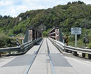
Road/rail bridges
There are two bridges on the State Highway on West CoastWest Coast, New Zealand
The West Coast is one of the administrative regions of New Zealand, located on the west coast of the South Island, and is one of the more remote and most sparsely populated areas of the country. It is made up of three districts: Buller, Grey and Westland...
that have rail lines on the road carriageway
Carriageway
A carriageway consists of a width of road on which a vehicle is not restricted by any physical barriers or separation to move laterally...
. Until 2008 the Awatere River
Awatere River
The Awatere River is a large river flowing through Marlborough, New Zealand. Flowing along the trace of the active Awatere Fault, it runs northeast through a straight valley to the west of the Inland Kaikoura mountains...
bridge had a rail line above the road way. A new road bridge has been constructed with the railway now being the sole use of the original bridge.
Footbridges

Backcountry
A backcountry area in general terms is a geographical region that is:* isolated* remote* undeveloped* difficult to accessThe term may apply to various regions that are reasonably close to urban areas but are:* not immediately accessible by car...
. During the 1950s many bridges were built, along with backcountry hut
Backcountry hut
Backcountry huts are huts that serve overnight hiking and trekking needs and can be found in many places in the world.-New Zealand:New Zealand has a network of approximately 950 backcountry huts...
s, to give hunters access to forested areas to cull introduced deer which had by that stage become a serious pest. Some of the bridges still remain but other have been washed away or replaced with new ones and are now often used due to the popularity of tramping (hiking).
Notable bridges
- The Auckland Harbour BridgeAuckland Harbour BridgeThe Auckland Harbour Bridge is an eight-lane box truss motorway bridge over the Waitemata Harbour, joining St Marys Bay in Auckland with Northcote in North Shore City, New Zealand. The bridge is part of State Highway 1 and the Auckland Northern Motorway...
spans the Waitemata Harbour in the largest city in New Zealand.
- The Bridge to Nowhere is a concrete road bridge spanning the Mangapurua Stream in Whanganui National Park. It has no roads leading to it, but it is a popular tourist attraction, accessible by boat or kayak. It was built in a failed attempt to open up a remote forested area for farming.
Bridge disasters and incidents
On April 30, during the 1951 New Zealand waterfront dispute1951 New Zealand waterfront dispute
The 1951 New Zealand waterfront dispute was the largest and most widespread industrial dispute in New Zealand history. During the time, up to twenty thousand workers went on strike in support of waterfront workers protesting financial hardships and working conditions. Thousands more refused to...
a rail bridge was blown up near Huntly
Huntly, New Zealand
Huntly is a town in the Waikato region of the North Island of New Zealand. It is on State Highway 1, 93 kilometres south of Auckland and 35 kilometres north of Hamilton. It is situated on the North Island Main Trunk Railway and straddles the Waikato River.Huntly was called Rahui Pokeka when...
. The train drivers were warned in advance and the bombing severely disrupted coal supplies.
Tangiwai disaster
The Tangiwai disasterTangiwai disaster
The Tangiwai disaster on 24 December 1953 was the worst rail accident in New Zealand history. An 11-carriage overnight express from Wellington to Auckland fell into the Whangaehu River at Tangiwai, ten kilometres west of Waiouru. The bridge carrying the North Island Main Trunk Railway over the...
on 24 December 1953, was the worst rail accident in New Zealand. The rail bridge over the Whangaehu river at Tangiwai had been badly damaged by a lahar
Lahar
A lahar is a type of mudflow or debris flow composed of a slurry of pyroclastic material, rocky debris, and water. The material flows down from a volcano, typically along a river valley. The term is a shortened version of "berlahar" which originated in the Javanese language of...
from Mount Ruapehu
Mount Ruapehu
Mount Ruapehu, or just Ruapehu, is an active stratovolcano at the southern end of the Taupo Volcanic Zone in New Zealand. It is 23 kilometres northeast of Ohakune and 40 kilometres southwest of the southern shore of Lake Taupo, within Tongariro National Park...
just minutes before a passenger train was due to cross it. 151 of the 285 passengers aboard the train were killed.
The Berrymans' bridge
In 1986 the New Zealand Army built the Te Rata BridgeTe Rata Bridge
The Te Rata Bridge was a suspension bridge across the Retaruke River in the King Country, New Zealand. On 22 March 1994 two transoms snapped causing the bridge to collapse while beekeeper Kenneth Richards was crossing in a laden light truck...
as a training exercise on a private farm owned by the Berryman family. In 1994 a beekeeper visiting the farm was killed when the bridge collapsed as he drove over it. The incident caused a series of high profile court cases.