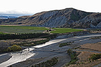
Awatere River
Encyclopedia

Marlborough, New Zealand
Marlborough is one of the regions of New Zealand, located in the northeast of the South Island. Marlborough is a unitary authority, both a region and a district, and its council is located at Blenheim. Marlborough is known for its dry climate, the picturesque Marlborough Sounds, and sauvignon blanc...
. Flowing along the trace of the active
Active fault
An active fault is a fault that is likely to have another earthquake sometime in the future. Faults are commonly considered to be active if there has been movement observed or evidence of seismic activity during the last 10,000 years....
Awatere Fault
Awatere Fault
The Awatere Fault is an active dextral strike-slip fault in the northeastern part of South Island, New Zealand. It forms part of the Marlborough Fault System, which accommodates the transfer of displacement along the oblique convergent boundary between the Indo-Australian Plate and Pacific Plate,...
, it runs northeast through a straight valley to the west of the Inland Kaikoura mountains
Kaikoura Ranges
The Kaikoura Ranges are two parallel ranges of mountains in the northeast of the South Island of New Zealand.Formed along New Zealand's Marlborough Fault System, they can be seen as the northernmost extension of the Southern Alps in the South Island....
. This valley is parallel with that of the Clarence River
Clarence River, New Zealand
Clarence River is located on South Island of New Zealand. It is 160 kilometres long.For its first 50 kilometres, the river runs in a generally southeastern direction. It then turns northeast, running down a long straight valley between the Inland and Seaward Kaikoura Ranges...
, 20 kilometres to the south.
It flows for 110 kilometres from its source in the mountainous interior to reach Cook Strait
Cook Strait
Cook Strait is the strait between the North and South Islands of New Zealand. It connects the Tasman Sea on the west with the South Pacific Ocean on the east....
close to the town of Seddon
Seddon, New Zealand
Seddon is a small town in Marlborough, New Zealand. It is located on State Highway 1, 25 kilometres south of Blenheim and 20 km north of Ward...
.
Until 2008 the Awatere River bridge had a rail line above the road way. A new road bridge was constructed with the railway being the sole use of the original bridge.

