

Percy Burn Viaduct
Encyclopedia
South Island
The South Island is the larger of the two major islands of New Zealand, the other being the more populous North Island. It is bordered to the north by Cook Strait, to the west by the Tasman Sea, to the south and east by the Pacific Ocean...
of New Zealand
New Zealand
New Zealand is an island country in the south-western Pacific Ocean comprising two main landmasses and numerous smaller islands. The country is situated some east of Australia across the Tasman Sea, and roughly south of the Pacific island nations of New Caledonia, Fiji, and Tonga...
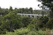
. It is reputedly the largest surviving wooden viaduct in the world. A former logging tramway, it is now a footbridge and the most popular feature of the Tuatapere
Tuatapere
Tuatapere is a small rural town in Southland, New Zealand . It is located eight kilometres from the southern coast. The Waiau River flows through the town before reaching Te Waewae Bay, where it has its outflow into Foveaux Strait...
Hump Ridge Track
Hump Ridge Track
The Hump Ridge Track is located in the south east of Fiordland National Park, South Island, New Zealand.Link to The Tuatapere Hump Ridge Track is 53 km, based in Waitutu Forest . The closest town is Tuatapere, although people often stay in Te Anau and opt to drive south the morning of...
.
During the early years of the twentieth century, logging companies exploited much of the native timber of New Zealand. The Marlborough
Marlborough, New Zealand
Marlborough is one of the regions of New Zealand, located in the northeast of the South Island. Marlborough is a unitary authority, both a region and a district, and its council is located at Blenheim. Marlborough is known for its dry climate, the picturesque Marlborough Sounds, and sauvignon blanc...
Timber Company, one of the country's largest forestry companies, was looking for new areas of forest to mill, and managed to secure the logging rights to an inhospitable and difficult to access area of timber close to Te Waewae Bay
Te Waewae Bay
Te Waewae Bay is the westernmost of three large bays lying on the Foveaux Strait coast of Southland, New Zealand, the others being Oreti Beach and Toetoes Bay...
in the island's southwestern corner.
Access was originally only available by ship, and a wharf and settlement were built at Port Craig
Port Craig, New Zealand
Port Craig is located along the south coast of the South Island New Zealand near Tuatapere.It was a small logging town born in 1916, with 200+ men women and children living there in its prime....
, but 25 kilometres of bush tramway were still needed to transport logs to the wharf. These had to cross four large, deep burns (ravine
Ravine
A ravine is a landform narrower than a canyon and is often the product of streamcutting erosion. Ravines are typically classified as larger in scale than gullies, although smaller than valleys. A ravine is generally a fluvial slope landform of relatively steep sides, on the order of twenty to...
s), and four large wood-trestle viaducts were built to accomplish this. The largest of these crossed the Percy Burn. Built in 1923, it was 125 metres in length and 36 metres high.
Unfortunately for the company, the timber was not of high quality and proved costly to log. Coupled with falling timber prices (due to the improvement of access between the South Island's cities and the heavily-forested West Coast
West Coast, New Zealand
The West Coast is one of the administrative regions of New Zealand, located on the west coast of the South Island, and is one of the more remote and most sparsely populated areas of the country. It is made up of three districts: Buller, Grey and Westland...
with the completion of the Otira
Otira
Otira is a small township seven kilometres north of Arthur's Pass in the central South Island of New Zealand. It is on the western approach to the pass, a saddle between the Otira and Bealey Rivers high in the Southern Alps...
tunnel), the Port Craig operation was quickly in trouble and was abandoned in 1928.
Restoration of the viaduct took place during the 1990s, as part of work on the new walking track.