

Bridges and tunnels in New York City
Encyclopedia
New York City
New York is the most populous city in the United States and the center of the New York Metropolitan Area, one of the most populous metropolitan areas in the world. New York exerts a significant impact upon global commerce, finance, media, art, fashion, research, technology, education, and...
's harbor and multiple waterways are what once made it the center of trade, but today they make it a city of bridges and tunnels. Over 2,000 of them provide uninterrupted vehicular movement throughout the region. Several agencies claim jurisdiction over this network of crossings including the Port Authority of New York and New Jersey
Port Authority of New York and New Jersey
The Port Authority of New York and New Jersey is a bi-state port district, established in 1921 through an interstate compact, that runs most of the regional transportation infrastructure, including the bridges, tunnels, airports, and seaports, within the Port of New York and New Jersey...
, the Metropolitan Transportation Authority
Metropolitan Transportation Authority (New York)
The Metropolitan Transportation Authority of the State of New York is a public benefit corporation responsible for public transportation in the U.S...
(MTA), DOT
Dot
- Typography :* Full stop, also called period in American English, used as a sentence terminator and as a decimal separator in numerals - Typography :* Full stop, also called period in American English, used as a sentence terminator and as a decimal separator (decimal point) in numerals -...
, New York State Department of Transportation
New York State Department of Transportation
The New York State Department of Transportation is responsible for the development and operation of highways, railroads, mass transit systems, ports, waterways and aviation facilities in the U.S...
, New York City Department of Environmental Protection
New York City Department of Environmental Protection
The New York City Department of Environmental Protection is a City agency of nearly 6,000 employees that manages and conserves the City’s water supply; distributes more than one billion gallons of clean drinking water each day to nine million New Yorkers and collects wastewater through a vast...
(DEP), Amtrak
Amtrak
The National Railroad Passenger Corporation, doing business as Amtrak , is a government-owned corporation that was organized on May 1, 1971, to provide intercity passenger train service in the United States. "Amtrak" is a portmanteau of the words "America" and "track". It is headquartered at Union...
and the New York City Department of Parks and Recreation
New York City Department of Parks and Recreation
The City of New York Department of Parks & Recreation is the department of government of the City of New York responsible for maintaining the city's parks system, preserving and maintaining the ecological diversity of the city's natural areas, and furnishing recreational opportunities for city's...
.
Nearly all of the city's major bridges and several of its tunnels, have broken or set records. The Holland Tunnel
Holland Tunnel
The Holland Tunnel is a highway tunnel under the Hudson River connecting the island of Manhattan in New York City with Jersey City, New Jersey at Interstate 78 on the mainland. Unusual for an American public works project, it is not named for a government official, politician, or local hero or...
was the world's first vehicular tunnel when it opened in 1927. The George Washington Bridge
George Washington Bridge
The George Washington Bridge is a suspension bridge spanning the Hudson River, connecting the Washington Heights neighborhood in the borough of Manhattan in New York City to Fort Lee, Bergen County, New Jersey. Interstate 95 and U.S. Route 1/9 cross the river via the bridge. U.S...
and Verrazano-Narrows Bridge
Verrazano-Narrows Bridge
The Verrazano-Narrows Bridge is a double-decked suspension bridge that connects the boroughs of Staten Island and Brooklyn in New York City at the Narrows, the reach connecting the relatively protected upper bay with the larger lower bay....
were the world's longest suspension bridge
Suspension bridge
A suspension bridge is a type of bridge in which the deck is hung below suspension cables on vertical suspenders. Outside Tibet and Bhutan, where the first examples of this type of bridge were built in the 15th century, this type of bridge dates from the early 19th century...
s when opened in 1931 and 1964 respectively.
Bridges
New York's crossings date back to 1693, when its first bridge, known as the King's Bridge, was constructed over Spuyten Duyvil Creek between ManhattanManhattan
Manhattan is the oldest and the most densely populated of the five boroughs of New York City. Located primarily on the island of Manhattan at the mouth of the Hudson River, the boundaries of the borough are identical to those of New York County, an original county of the state of New York...
and the Bronx. The bridge, composed of stone abutments and a timber deck, was demolished in 1917. The oldest crossing still standing is High Bridge
High Bridge (New York City)
The High Bridge is a steel arch bridge, with a height of almost 140 feet over the Harlem River, connecting the New York City boroughs of The Bronx and Manhattan...
which connects Manhattan to the Bronx over the Harlem River
Harlem River
The Harlem River is a navigable tidal strait in New York City, USA that flows 8 miles between the Hudson River and the East River, separating the boroughs of Manhattan and the Bronx...
. This bridge was built to carry water to the city as part of the Croton Aqueduct
Croton Aqueduct
The Croton Aqueduct or Old Croton Aqueduct was a large and complex water distribution system constructed for New York City between 1837 and 1842...
system.
Ten bridge
Bridge
A bridge is a structure built to span physical obstacles such as a body of water, valley, or road, for the purpose of providing passage over the obstacle...
s and 1 tunnel
Tunnel
A tunnel is an underground passageway, completely enclosed except for openings for egress, commonly at each end.A tunnel may be for foot or vehicular road traffic, for rail traffic, or for a canal. Some tunnels are aqueducts to supply water for consumption or for hydroelectric stations or are sewers...
serving the city have been awarded some level of landmark status. The Holland Tunnel
Holland Tunnel
The Holland Tunnel is a highway tunnel under the Hudson River connecting the island of Manhattan in New York City with Jersey City, New Jersey at Interstate 78 on the mainland. Unusual for an American public works project, it is not named for a government official, politician, or local hero or...
was designated a National Historic Landmark
National Historic Landmark
A National Historic Landmark is a building, site, structure, object, or district, that is officially recognized by the United States government for its historical significance...
in 1993 in recognition of its pioneering role as the first mechanically ventilated vehicular underwater tunnel, operating since 1927. The George Washington
George Washington Bridge
The George Washington Bridge is a suspension bridge spanning the Hudson River, connecting the Washington Heights neighborhood in the borough of Manhattan in New York City to Fort Lee, Bergen County, New Jersey. Interstate 95 and U.S. Route 1/9 cross the river via the bridge. U.S...
, High Bridge
High Bridge (New York City)
The High Bridge is a steel arch bridge, with a height of almost 140 feet over the Harlem River, connecting the New York City boroughs of The Bronx and Manhattan...
, Hell Gate
Hell Gate Bridge
The Hell Gate Bridge or Hell's Gate Bridge is a steel through arch railroad bridge between Astoria in the borough of Queens and Randall's and Wards Islands in New York City, over a portion of the East River known...
, Queensboro
Queensboro Bridge
The Ed Koch Queensboro Bridge, also known as the 59th Street Bridge – because its Manhattan end is located between 59th and 60th Streets – or simply the Queensboro Bridge, is a cantilever bridge over the East River in New York City that was completed in 1909...
, Brooklyn
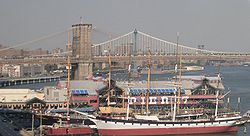
Brooklyn Bridge
The Brooklyn Bridge is one of the oldest suspension bridges in the United States. Completed in 1883, it connects the New York City boroughs of Manhattan and Brooklyn by spanning the East River...
, Manhattan
Manhattan Bridge
The Manhattan Bridge is a suspension bridge that crosses the East River in New York City, connecting Lower Manhattan with Brooklyn . It was the last of the three suspension bridges built across the lower East River, following the Brooklyn and the Williamsburg bridges...
, Macombs Dam
Macombs Dam Bridge
Macombs Dam Bridge is a swing bridge that spans the Harlem River in New York City, connecting the boroughs of Manhattan and the Bronx near Yankee Stadium. It is the third-oldest bridge in New York City and was designated an official landmark in January 1992...
, Carroll Street, University Heights and Washington
Washington Bridge
The Washington Bridge carries six lanes of traffic over the Harlem River in New York City between the boroughs of Manhattan and the Bronx, connecting 181st Street and Amsterdam Avenue in the Washington Heights section of Manhattan to University Avenue in the Morris Heights section of the Bronx...
bridges have all received landmark status as well.
New York features bridges of all lengths and types, carrying everything from cars, trucks and subway trains to pedestrians and bicycles. The George Washington Bridge
George Washington Bridge
The George Washington Bridge is a suspension bridge spanning the Hudson River, connecting the Washington Heights neighborhood in the borough of Manhattan in New York City to Fort Lee, Bergen County, New Jersey. Interstate 95 and U.S. Route 1/9 cross the river via the bridge. U.S...
, spanning the Hudson River
Hudson River
The Hudson is a river that flows from north to south through eastern New York. The highest official source is at Lake Tear of the Clouds, on the slopes of Mount Marcy in the Adirondack Mountains. The river itself officially begins in Henderson Lake in Newcomb, New York...
between New York City and Fort Lee, New Jersey
Fort Lee, New Jersey
Fort Lee is a borough in Bergen County, New Jersey, United States. As of the 2010 United States Census, the borough population was 35,345. Located atop the Hudson Palisades, the borough is the western terminus of the George Washington Bridge...
, is the world's busiest bridge in terms of vehicular traffic. The George Washington Bridge, Verrazano Narrows Bridge and the Brooklyn Bridge
Brooklyn Bridge
The Brooklyn Bridge is one of the oldest suspension bridges in the United States. Completed in 1883, it connects the New York City boroughs of Manhattan and Brooklyn by spanning the East River...
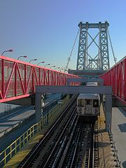
are considered among the most beautiful in the world. Others are more well known for their functional importance such as the Williamsburg Bridge
Williamsburg Bridge
The Williamsburg Bridge is a suspension bridge in New York City across the East River connecting the Lower East Side of Manhattan at Delancey Street with the Williamsburg neighborhood of Brooklyn at Broadway near the Brooklyn-Queens Expressway...
which has 2 heavy rail transit tracks, 8 traffic lanes and a pedestrian sidewalk.
East River
| Name | Opening year | Length | Comments |
|---|---|---|---|
| Brooklyn Bridge Brooklyn Bridge The Brooklyn Bridge is one of the oldest suspension bridges in the United States. Completed in 1883, it connects the New York City boroughs of Manhattan and Brooklyn by spanning the East River... |
1883 | 1825 m | Oldest suspension bridge |
| Manhattan Bridge Manhattan Bridge The Manhattan Bridge is a suspension bridge that crosses the East River in New York City, connecting Lower Manhattan with Brooklyn . It was the last of the three suspension bridges built across the lower East River, following the Brooklyn and the Williamsburg bridges... |
1909 | 2089 m | ( subway service) |
| Williamsburg Bridge Williamsburg Bridge The Williamsburg Bridge is a suspension bridge in New York City across the East River connecting the Lower East Side of Manhattan at Delancey Street with the Williamsburg neighborhood of Brooklyn at Broadway near the Brooklyn-Queens Expressway... |
1903 | 2227.48 m | ( subway service) |
| Ed Koch Queensboro Bridge | 1909 | 1135.0 m | |Also known as 59th Street Bridge |
| Roosevelt Island Bridge Roosevelt Island Bridge The Roosevelt Island Bridge is a lift bridge that connects Roosevelt Island to Astoria in Queens, crossing the East Channel of the East River. It is the sole route to the island for vehicular and foot traffic .... |
1955 | 876.91 m | East channel only |
| Robert F. Kennedy Bridge | 1936 | 1569.72 m | I-278 Interstate 278 Interstate 278 is an auxiliary Interstate Highway in New Jersey and New York, United States. The road runs from U.S. Route 1/9 in Linden, New Jersey to the Bruckner Interchange in the New York City borough of the Bronx... formerly named The Triboro Bridge |
| Hell Gate Bridge Hell Gate Bridge The Hell Gate Bridge or Hell's Gate Bridge is a steel through arch railroad bridge between Astoria in the borough of Queens and Randall's and Wards Islands in New York City, over a portion of the East River known... |
1916 | 5181.6 m | Rail only |
| Rikers Island Bridge | 1966 | 1280.16 m | Only connects Rikers Island Rikers Island Rikers Island is New York City's main jail complex, as well as the name of the island on which it sits, in the East River between Queens and the mainland Bronx, adjacent to the runways of LaGuardia Airport. The island itself is part of the borough of the Bronx, though it is included as part of... to Queens |
| Bronx–Whitestone Bridge | 1939 | 1149.10 m | I-678 Interstate 678 Interstate 678 is a north–south auxiliary Interstate Highway that extends for through two boroughs of New York City. The route begins at John F. Kennedy International Airport on Jamaica Bay and travels north through Queens and across the East River to the Bronx, where it ends at... |
| Throgs Neck Bridge Throgs Neck Bridge The Throgs Neck Bridge is a suspension bridge opened on January 11, 1961, which carries Interstate 295 over the East River where it meets the Long Island Sound. The bridge connects the Throggs Neck section of the Bronx with the Bay Terrace section of Queens... |
1961 | 886.97 m | I-295 |
Harlem River

| Name | Opening year | Length | Comments |
|---|---|---|---|
| Wards Island Bridge | 1951 | 285.6m | Pedestrian only |
| Robert F. Kennedy Bridge | 1936 | 1569.72 m | |
| Willis Avenue Bridge Willis Avenue Bridge The Willis Avenue Bridge is a swing bridge that carries road traffic northbound over the Harlem River between the New York City boroughs of Manhattan and the Bronx, United States. It connects First Avenue in Manhattan with Willis Avenue in the Bronx... |
1901 | ||
| Third Avenue Bridge | 1898 | ||
| Park Avenue Bridge | 1954 | Metro-North Railroad Metro-North Railroad The Metro-North Commuter Railroad , trading as MTA Metro-North Railroad, or, more commonly, Metro-North, is a suburban commuter rail service that is run and managed by the Metropolitan Transportation Authority , an authority of New York State. It is the busiest commuter railroad in the United... |
|
| Madison Avenue Bridge Madison Avenue Bridge The Madison Avenue Bridge crosses the Harlem River connecting Madison Avenue in Manhattan with East 138th Street in the Bronx in New York City. The bridge is operated and maintained by the New York City Department of Transportation. It was designed by Alfred P... |
1910 | ||
| 145th Street Bridge 145th Street Bridge The 145th Street Bridge, located in New York City, USA, is a four-lane swing bridge that crosses the Harlem River, connecting 145th Street and Lenox Avenue in Manhattan with East 149th Street and River Avenue in the Bronx. It once carried northbound New York State Route 22 and New York State Route... |
1905 | ||
| Macombs Dam Bridge Macombs Dam Bridge Macombs Dam Bridge is a swing bridge that spans the Harlem River in New York City, connecting the boroughs of Manhattan and the Bronx near Yankee Stadium. It is the third-oldest bridge in New York City and was designated an official landmark in January 1992... |
1895 | 774 m | |
| High Bridge High Bridge (New York City) The High Bridge is a steel arch bridge, with a height of almost 140 feet over the Harlem River, connecting the New York City boroughs of The Bronx and Manhattan... |
1848 | 600 m | Oldest surviving bridge in New York City. Currently closed for repairs. |
| Alexander Hamilton Bridge Alexander Hamilton Bridge The Alexander Hamilton Bridge carries eight lanes of traffic over the Harlem River in New York City between the boroughs of Manhattan and the Bronx, connecting the Trans-Manhattan Expressway in the Washington Heights section of Manhattan and the Cross-Bronx Expressway, as part of Interstate 95... |
1963 | 724 m | I-95 Interstate 95 in New York Interstate 95 is a part of the Interstate Highway System that runs from Miami, Florida, to the Canada – United States border near Houlton, Maine. In the U.S. state of New York, I-95 extends from the George Washington Bridge in New York City to the Connecticut state line at Port Chester... |
| Washington Bridge Washington Bridge The Washington Bridge carries six lanes of traffic over the Harlem River in New York City between the boroughs of Manhattan and the Bronx, connecting 181st Street and Amsterdam Avenue in the Washington Heights section of Manhattan to University Avenue in the Morris Heights section of the Bronx... |
1888 | 723.9 m | |
| University Heights Bridge | 1908 | 82 m | |
| Broadway Bridge | 1962 | Also known as Harlem Ship Canal Bridge ( subway service) |
|
| Henry Hudson Bridge Henry Hudson Bridge The Henry Hudson Bridge is a steel arch toll bridge in New York City across the Spuyten Duyvil Creek. It connects the Spuyten Duyvil section of The Bronx with the northern end of Manhattan to the south. On the Manhattan side, it touches Inwood Hill Park. The bridge was designed by David B. Steinman... |
1936 | 673 m | |
| Spuyten Duyvil Bridge Spuyten Duyvil Bridge The Spuyten Duyvil Bridge is a swing bridge that carries Amtrak's Empire Corridor line across the Spuyten Duyvil Creek between Manhattan and the Bronx, in New York City. The bridge is located at the northern tip of Manhattan where the Spuyten Duyvil Creek meets the Hudson River, approximately to... |
1899 | Rail only |
Hudson River
| Name | Opening year | Length | Comments |
|---|---|---|---|
| George Washington Bridge George Washington Bridge The George Washington Bridge is a suspension bridge spanning the Hudson River, connecting the Washington Heights neighborhood in the borough of Manhattan in New York City to Fort Lee, Bergen County, New Jersey. Interstate 95 and U.S. Route 1/9 cross the river via the bridge. U.S... |
1931 | 1450.85 m | Handles 290,000 vehicles per day) |
New York Bay
| Name | Opening year | Length | Comments |
|---|---|---|---|
| Verrazano-Narrows Bridge Verrazano-Narrows Bridge The Verrazano-Narrows Bridge is a double-decked suspension bridge that connects the boroughs of Staten Island and Brooklyn in New York City at the Narrows, the reach connecting the relatively protected upper bay with the larger lower bay.... |
1964 | 2039.1 m | I-278 Interstate 278 Interstate 278 is an auxiliary Interstate Highway in New Jersey and New York, United States. The road runs from U.S. Route 1/9 in Linden, New Jersey to the Bruckner Interchange in the New York City borough of the Bronx... |
Newtown Creek
| Name | Opening year | Length | Comments |
|---|---|---|---|
| Kosciusko Bridge | 1939 | 1,835 m | I-278 Interstate 278 Interstate 278 is an auxiliary Interstate Highway in New Jersey and New York, United States. The road runs from U.S. Route 1/9 in Linden, New Jersey to the Bruckner Interchange in the New York City borough of the Bronx... |
| Pulaski Bridge Pulaski Bridge The Pulaski Bridge in New York City connects Long Island City in Queens to Greenpoint in Brooklyn over Newtown Creek. It was named after Polish military commander and American Revolutionary War fighter Kazimierz Pułaski because of the large Polish-American population in Greenpoint... |
1954 | 860 m | McGuinness Blvd. |
| J. J. Byrne Memorial Bridge | 1987 | 55 m | a.k.a. Greenpoint Avenue Bridge Greenpoint Avenue Bridge The Greenpoint Avenue Bridge is a drawbridge that carries Greenpoint Avenue across Newtown Creek between Greenpoint, Brooklyn and Blissville, Queens. Greenpoint Avenue continues eastward into Queens where it connects to Roosevelt Avenue.... |
| Grand Street Bridge | |||
| Metropolitan Avenue Bridge |
The Bronx
| Name | Opening year | Length | Comments |
|---|---|---|---|
| Hutchinson River (heading upriver) | |||
| Pelham Bridge Pelham Bridge Pelham Bridge is a bascule bridge located in the New York City borough of the Bronx. It carries Shore Road, and a walkway along the downstream side, over the Hutchinson River. The bridge is operated and maintained by the New York City Department of Transportation.Unlike most movable bridges in the... |
1908 | Shore Road | |
| Hutchinson River Pky Bridge | |||
| Westchester Creek Westchester Creek Westchester Creek is a tidal inlet of the East River located in the south eastern portion of The Bronx in New York City. It is 2.1 miles in length... |
|||
| Unionport Bridge | |||
| Bronx River Bronx River The Bronx River, approximately long, flows through southeast New York in the United States. It is named after colonial settler Jonas Bronck. The Bronx River is the only fresh water river in New York City.... |
|||
| Eastern Boulevard Bridge | I-278 Interstate 278 Interstate 278 is an auxiliary Interstate Highway in New Jersey and New York, United States. The road runs from U.S. Route 1/9 in Linden, New Jersey to the Bruckner Interchange in the New York City borough of the Bronx... |
||
| Pelham Bay Pelham Bay Pelham Bay is a small bay, between City Island and Orchard Beach in the Bronx, New York.Technically, it is a sound, not a bay, since it is open to larger bodies of water at both ends. It connects to Eastchester Bay at the south, and opens onto Long Island Sound and City Island Harbor at the... |
|||
| City Island Bridge City Island Bridge The City Island Bridge is a bridge in the New York City borough of the Bronx, connecting City Island and Rodman's Neck on the mainland. It is of stone and steel construction, and spans 950 ft . Construction was begun in 1899 and completed in 1901, at a cost of $200,000... |
1901 | City Island Road | |
Brooklyn
| Name | Opening year | Length | Comments |
|---|---|---|---|
| Mill Basin | |||
| Mill Basin Bridge | |||
| Gowanus Canal Gowanus Canal The Gowanus Canal, also known as the Gowanus Creek Canal, is a canal in the New York City borough of Brooklyn, geographically on the westernmost portion of Long Island... |
|||
| Union Street Bridge | |||
| Carroll Street Bridge | |||
| Third Street Bridge | |||
| Ninth Street Bridge | ( subway service) | ||
| Hamilton Avenue Bridge | |||
| Rockaway Inlet Rockaway Inlet Rockaway Inlet is a strait connecting Jamaica Bay, wholly within New York City, with the Atlantic Ocean. It separates the Rockaway Peninsula in Queens from the Floyd Bennett Field in Brooklyn.... (Brooklyn and Queens) |
|||
| Marine Parkway-Gil Hodges Memorial Bridge Marine Parkway-Gil Hodges Memorial Bridge The Marine Parkway-Gil Hodges Memorial Bridge in New York City is a vertical lift bridge that crosses Rockaway Inlet and connects the Rockaway Peninsula in Queens, with Marine Parkway to Floyd Bennett Field, Flatbush Avenue, and the Marine Park neighborhood in Brooklyn... |
1937 | 1226 m | |
Queens
| Name | Opening year | Length | Comments |
|---|---|---|---|
| Dutch Kills | |||
| Borden Avenue Bridge | |||
| Hunters Point Avenue Bridge | |||
| Jamaica Bay Jamaica Bay Jamaica Bay is located on the southwestern tip of Long Island in the boroughs of Brooklyn and Queens, New York City, and the town of Hempstead, New York/hamlet of Inwood... |
|||
| Cross Bay Veterans Memorial Bridge Cross Bay Veterans Memorial Bridge The Cross Bay Veterans Memorial Bridge in New York City, is a toll bridge that carries Cross Bay Boulevard from Broad Channel in Jamaica Bay to the Rockaway Peninsula, and is located in Queens.... |
1970 | ||
| The Joseph P. Addabbo Memorial Bridge | |||
| Grassy Bay Subway Bridge | ( subway service) Howard Beach to Broad Channel Broad Channel, Queens Broad Channel is a neighborhood in the New York City borough of Queens. It occupies the southern portion of Rulers Bar Hassock , which is the only inhabited island in Jamaica Bay. The neighborhood stands on Big Egg Marsh, an area of fill approximately 20 blocks long and 4 blocks wide... . |
||
| South Channel Subway Bridge | ( subway service) Swing Bridge, Broad Channel Broad Channel, Queens Broad Channel is a neighborhood in the New York City borough of Queens. It occupies the southern portion of Rulers Bar Hassock , which is the only inhabited island in Jamaica Bay. The neighborhood stands on Big Egg Marsh, an area of fill approximately 20 blocks long and 4 blocks wide... to The Rockaways |
||
| 102nd Street Bridge | Connecting Hamilton Beach Hamilton Beach, Queens Hamilton Beach, one of the oldest sections of Howard Beach, is a neighborhood in the New York City borough of Queens. Its boundaries are the 102nd Street Creek to the north, the IND Rockaway Line tracks and JFK Airport to the east, Hawtree Creek to the west, and Jamaica Bay to the south... at Russell Street with Howard Beach Howard Beach, Queens Howard Beach is a suburban neighborhood in the southwestern portion of the borough of Queens in New York City. It is bordered in the north by the Belt Parkway and South Conduit Avenue in Ozone Park, the south by Jamaica Bay in Broad Channel, the east by 102nd-104th streets, and the west by 78th... , also known as "Lenihan's Bridge". |
||
| Hawtree Creek Bridge | 163rd Avenue and 99th Street in Howard Beach Howard Beach, Queens Howard Beach is a suburban neighborhood in the southwestern portion of the borough of Queens in New York City. It is bordered in the north by the Belt Parkway and South Conduit Avenue in Ozone Park, the south by Jamaica Bay in Broad Channel, the east by 102nd-104th streets, and the west by 78th... across to Hamilton Beach Hamilton Beach, Queens Hamilton Beach, one of the oldest sections of Howard Beach, is a neighborhood in the New York City borough of Queens. Its boundaries are the 102nd Street Creek to the north, the IND Rockaway Line tracks and JFK Airport to the east, Hawtree Creek to the west, and Jamaica Bay to the south... at Rau Court and Davenport Court |
||
| Rockaway Inlet Rockaway Inlet Rockaway Inlet is a strait connecting Jamaica Bay, wholly within New York City, with the Atlantic Ocean. It separates the Rockaway Peninsula in Queens from the Floyd Bennett Field in Brooklyn.... (Brooklyn and Queens) |
|||
| Marine Parkway-Gil Hodges Memorial Bridge Marine Parkway-Gil Hodges Memorial Bridge The Marine Parkway-Gil Hodges Memorial Bridge in New York City is a vertical lift bridge that crosses Rockaway Inlet and connects the Rockaway Peninsula in Queens, with Marine Parkway to Floyd Bennett Field, Flatbush Avenue, and the Marine Park neighborhood in Brooklyn... |
1937 | 1226 m | |
Staten Island
| Name | Opening year | Length | Comments |
|---|---|---|---|
| Arthur Kill Arthur Kill The Arthur Kill is a tidal strait separating Staten Island, New York from mainland New Jersey, USA, and a major navigational channel of the Port of New York and New Jersey. Kill is from the Middle Dutch word kille, meaning "riverbed" or "water channel"... |
|||
| Goethals Bridge Goethals Bridge The Goethals Bridge connects Elizabeth, New Jersey to Staten Island , near the Howland Hook Marine Terminal, Staten Island, New York over the Arthur Kill. Operated by the Port Authority of New York and New Jersey, the span was one of the first structures built by the authority... |
1928 | 2164.08 m | I-278 Interstate 278 Interstate 278 is an auxiliary Interstate Highway in New Jersey and New York, United States. The road runs from U.S. Route 1/9 in Linden, New Jersey to the Bruckner Interchange in the New York City borough of the Bronx... |
| Arthur Kill Vertical Lift Bridge Arthur Kill Vertical Lift Bridge The Arthur Kill Vertical Lift Railroad Bridge is a railroad-only, vertical lift bridge connecting Elizabethport, New Jersey and the Howland Hook Marine Terminal on Staten Island. The bridge was built by the Baltimore and Ohio Railroad in 1959 to replace an older swing span... |
1959 | 170.08 m | CSX and M&E Morristown and Erie Railway The Morristown and Erie Railway is a freight short line railroad based in Morristown, New Jersey. It operates freight rail service five days a week in Morris County, New Jersey and surrounding areas... rail lines |
| Outerbridge Crossing Outerbridge Crossing The Outerbridge Crossing is a cantilever bridge which spans the Arthur Kill. The "Outerbridge", as it is commonly known, connects Perth Amboy, New Jersey, with the New York City borough of Staten Island and carries NY-440 and NJ-440, each road ending at the respective state border.The bridge was... |
1928 | 3093 m | NJ 440 Route 440 (New Jersey) Route 440 is a state highway in New Jersey, United States. It is composed of two segments, a freeway in Middlesex County linking Interstate 287 and the New Jersey Turnpike in Edison to the Outerbridge Crossing in Perth Amboy and a four-lane divided highway in Hudson County running from the... /NY 440 |
| Kill Van Kull Kill Van Kull The Kill Van Kull is a tidal strait between Staten Island, New York and Bayonne, New Jersey in the United States. Approximately long and wide, it connects Newark Bay with Upper New York Bay. The Robbins Reef Light marks the eastern end of the Kill, Bergen Point its western end... |
|||
| Bayonne Bridge Bayonne Bridge The Bayonne Bridge is the fourth longest steel arch bridge in the world, and was the longest in the world at the time of its completion. It connects Bayonne, New Jersey with Staten Island, New York, spanning the Kill Van Kull. Despite popular belief, it is not a national landmark.The bridge was... |
1931 | 1761.74 m | NY 440 New York State Route 440 New York State Route 440 is a state highway located entirely on Staten Island in New York City. The route acts as a connector between the two segments of New Jersey Route 440, running from the Staten Island community of Richmond Valley to the south to Port Richmond to the north... /NJ 440 Route 440 (New Jersey) Route 440 is a state highway in New Jersey, United States. It is composed of two segments, a freeway in Middlesex County linking Interstate 287 and the New Jersey Turnpike in Edison to the Outerbridge Crossing in Perth Amboy and a four-lane divided highway in Hudson County running from the... |
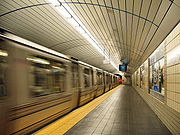
Tunnels
In contrast to New York's bridges, its tunnels receive substantially less attention and praise. Yet the four vehicle tunnels that connect ManhattanManhattan
Manhattan is the oldest and the most densely populated of the five boroughs of New York City. Located primarily on the island of Manhattan at the mouth of the Hudson River, the boundaries of the borough are identical to those of New York County, an original county of the state of New York...
with Long Island
Long Island
Long Island is an island located in the southeast part of the U.S. state of New York, just east of Manhattan. Stretching northeast into the Atlantic Ocean, Long Island contains four counties, two of which are boroughs of New York City , and two of which are mainly suburban...
and New Jersey
New Jersey
New Jersey is a state in the Northeastern and Middle Atlantic regions of the United States. , its population was 8,791,894. It is bordered on the north and east by the state of New York, on the southeast and south by the Atlantic Ocean, on the west by Pennsylvania and on the southwest by Delaware...
– the Brooklyn Battery, Queens Midtown
Queens Midtown Tunnel
The Queens–Midtown Tunnel is a highway tunnel and toll road in New York City. It crosses under the East River and connects the Borough of Queens on Long Island with the Borough of Manhattan The Queens–Midtown Tunnel (sometimes simply known as the Midtown Tunnel) is a highway tunnel and toll road...
, Holland
Holland Tunnel
The Holland Tunnel is a highway tunnel under the Hudson River connecting the island of Manhattan in New York City with Jersey City, New Jersey at Interstate 78 on the mainland. Unusual for an American public works project, it is not named for a government official, politician, or local hero or...
and Lincoln
Lincoln Tunnel
The Lincoln Tunnel is a long tunnel under the Hudson River, connecting Weehawken, New Jersey and the borough of Manhattan in New York City.-History:...
– are a critical part of managing the flow of people into and out of the city each day.
Each of the tunnels that run underneath the East
East River
The East River is a tidal strait in New York City. It connects Upper New York Bay on its south end to Long Island Sound on its north end. It separates Long Island from the island of Manhattan and the Bronx on the North American mainland...
and Hudson
Hudson River
The Hudson is a river that flows from north to south through eastern New York. The highest official source is at Lake Tear of the Clouds, on the slopes of Mount Marcy in the Adirondack Mountains. The river itself officially begins in Henderson Lake in Newcomb, New York...
rivers were marvels of engineering when first constructed. The Holland Tunnel
Holland Tunnel
The Holland Tunnel is a highway tunnel under the Hudson River connecting the island of Manhattan in New York City with Jersey City, New Jersey at Interstate 78 on the mainland. Unusual for an American public works project, it is not named for a government official, politician, or local hero or...
is the oldest of the vehicular tunnels, opening to great fanfare in 1927 as the first mechanically ventilated underwater tunnel. The Queens Midtown Tunnel
Queens Midtown Tunnel
The Queens–Midtown Tunnel is a highway tunnel and toll road in New York City. It crosses under the East River and connects the Borough of Queens on Long Island with the Borough of Manhattan The Queens–Midtown Tunnel (sometimes simply known as the Midtown Tunnel) is a highway tunnel and toll road...
was opened in 1940 to relieve the congestion on the city's bridges. Each of its tubes were designed 1½ feet wider than the Holland Tunnel in order to accommodate the wider cars of the period. When the Brooklyn Battery Tunnel opened in 1950 it was the longest continuous underwater vehicular tunnel in the world, a title which it still holds. The Lincoln Tunnel
Lincoln Tunnel
The Lincoln Tunnel is a long tunnel under the Hudson River, connecting Weehawken, New Jersey and the borough of Manhattan in New York City.-History:...
has three tubes linking midtown Manhattan
Manhattan
Manhattan is the oldest and the most densely populated of the five boroughs of New York City. Located primarily on the island of Manhattan at the mouth of the Hudson River, the boundaries of the borough are identical to those of New York County, an original county of the state of New York...
to New Jersey
New Jersey
New Jersey is a state in the Northeastern and Middle Atlantic regions of the United States. , its population was 8,791,894. It is bordered on the north and east by the state of New York, on the southeast and south by the Atlantic Ocean, on the west by Pennsylvania and on the southwest by Delaware...
, a configuration which provides the flexibility to provide four lanes in one direction during rush-hour or three lanes in each direction.
All four underwater road tunnels were built by Ole Singstad
Ole Singstad
Ole Knutsen Singstad was a Norwegian-American civil engineer who innovated the ventilation system for the Holland Tunnel and advanced the use of the "Sunk-tube" method of underwater vehicular tunnel building, a system of constructing the tunnels with prefabricated sections.By 1950...
: the Holland Tunnel's original chief engineer Clifford Milburn Holland
Clifford Milburn Holland
Clifford Milburn Holland was born in Somerset, Massachusetts. He was the only child of Edward John Holland and Lydia Frances Hood. He graduated from Harvard University with a B.A. in 1905 and a B.S. in Civil Engineering in 1906. On November 5, 1908 he married Anna Coolidge Davenport...
died, as did his successor, Milton H. Freeman, after which Singstad became chief engineer, finishing the Holland Tunnel and then building the remaining tunnels.
East River

| Name | Opening year | Length | Comments |
|---|---|---|---|
| Brooklyn–Battery Tunnel | 1950 | 9117 ft (2,778.9 m) | I-478 |
| Joralemon Street Tunnel Joralemon Street Tunnel The Joralemon Street Tunnel carries the trains of the IRT Lexington Avenue Line of the New York City Subway under the East River from the Bowling Green neighborhood in Manhattan to Joralemon Street and Willow Place in Brooklyn... |
1908 | IRT Lexington Avenue Line IRT Lexington Avenue Line The Lexington Avenue Line is one of the lines of the IRT division of the New York City Subway, stretching from Downtown Brooklyn or Lower Manhattan north to 125th Street in East Harlem. The portion in Lower and Midtown Manhattan was part of the first subway line in New York... ( subway services) |
|
| Montague Street Tunnel Montague Street Tunnel The Montague Street Tunnel carries the trains of the New York City Subway under the East River between the boroughs of Manhattan and Brooklyn. It opened to revenue service on Sunday, August 1, 1920 at 2 am with a holiday schedule, the same day as the 60th Street Tunnel. Regular service began... |
1920 | BMT Broadway Line BMT Broadway Line The BMT Broadway Line is a rapid transit line of the B Division of the New York City Subway in Manhattan, New York City, United States. , it is served by three services, all colored yellow: the on the express tracks and the on the local tracks... ( subway services) |
|
| Clark Street Tunnel Clark Street Tunnel The Clark Street Tunnel carries the trains of the New York City Subway under the East River between the boroughs of Manhattan and Brooklyn. It was opened for revenue service on Tuesday, April 15, 1919, relieving crowding on the Joralemon Street Tunnel and providing passengers with a direct route... |
1919 | 5900 ft (1,798.3 m) | IRT Broadway – Seventh Avenue Line ( subway services) |
| Cranberry Street Tunnel Cranberry Street Tunnel The Cranberry Street Tunnel carries the trains of the New York City Subway under the East River between the Fulton Street Station in Manhattan and the High Street – Brooklyn Bridge Station in Brooklyn. Its Brooklyn ventilation shaft is visible from Furman Street... |
1933 | IND Eighth Avenue Line IND Eighth Avenue Line The Eighth Avenue Line is a rapid transit line in New York City, United States, and is part of the B Division of the New York City Subway... ( subway services) |
|
| Rutgers Street Tunnel | 1936 | IND Sixth Avenue Line IND Sixth Avenue Line The Sixth Avenue Line is a rapid transit line of the B Division of the New York City Subway in the United States. It runs mainly under Sixth Avenue in Manhattan, and continues south through the Rutgers Street Tunnel to Brooklyn... ( subway service) |
|
| 14th Street Tunnel 14th Street Tunnel The 14th Street Tunnel carries the train of the New York City Subway under the East River between the First Avenue Station in the borough of Manhattan and the Bedford Avenue Station in Brooklyn.... |
1924 | BMT Canarsie Line BMT Canarsie Line The Canarsie Line is a rapid transit line of the BMT Division of the New York City Subway system, named after its terminus in the Canarsie neighborhood of Brooklyn... ( subway service) |
|
| East River Tunnels East River Tunnels The East River Tunnels are 4 single-track railroad tunnels that extend from the eastern end of Pennsylvania Station under 32nd and 33rd Streets in Manhattan and cross the East River to Long Island City in Queens. The tracks carry Long Island Rail Road and Amtrak trains travelling to and from Penn... |
1910 | 3949 ft (1,203.7 m) | part of the New York Tunnel Extension Amtrak Amtrak The National Railroad Passenger Corporation, doing business as Amtrak , is a government-owned corporation that was organized on May 1, 1971, to provide intercity passenger train service in the United States. "Amtrak" is a portmanteau of the words "America" and "track". It is headquartered at Union... and Long Island Rail Road Long Island Rail Road The Long Island Rail Road or LIRR is a commuter rail system serving the length of Long Island, New York. It is the busiest commuter railroad in North America, serving about 81.5 million passengers each year. Established in 1834 and having operated continuously since then, it is the oldest US... (Northeast Corridor Northeast Corridor The Northeast Corridor is a fully electrified railway line owned primarily by Amtrak serving the Northeast megalopolis of the United States from Boston in the north, via New York to Washington, D.C. in the south, with branches serving other cities... ) |
| Queens–Midtown Tunnel | 1940 | 6414 ft (1,955 m) | I-495 Interstate 495 (New York) Interstate 495 is an auxiliary Interstate Highway on Long Island in New York in the United States. The route extends for from the western portal of the Queens-Midtown Tunnel in the New York City borough of Manhattan to County Route 58 in Riverhead, Suffolk County... |
| Steinway Tunnel Steinway Tunnel The Steinway Tunnel carries the trains of the New York City Subway under the East River between 42nd Street in Manhattan and 51st Avenue in Long Island City, Queens, in New York City. It was originally designed and built as an interurban trolley tunnel , with stations near the trains' current... |
1915 | IRT Flushing Line IRT Flushing Line The Flushing Line is a rapid transit route of the New York City Subway system, operated as part of the IRT Division and designated the 7 route... ( subway services) |
|
| 53rd Street Tunnel 53rd Street Tunnel The 53rd Street Tunnel carries the IND Queens Boulevard Line of the New York City Subway under the East River and Roosevelt Island between Manhattan and Queens, New York City.... |
1933 | IND Queens Boulevard Line IND Queens Boulevard Line The Queens Boulevard Line is a fully underground line of the B Division of the New York City Subway in Manhattan and Queens, New York City, United States. The line provides crosstown service across Manhattan under 53rd Street and east through Queens to Jamaica... ( subway services) |
|
| 60th Street Tunnel 60th Street Tunnel The 60th Street Tunnel carries the trains of the New York City Subway under the East River and Roosevelt Island between Manhattan and Queens.The tunnel was built as part of the Dual Contracts period of New York City subway construction... |
1920 | BMT Broadway Line BMT Broadway Line The BMT Broadway Line is a rapid transit line of the B Division of the New York City Subway in Manhattan, New York City, United States. , it is served by three services, all colored yellow: the on the express tracks and the on the local tracks... ( subway services) |
|
| 63rd Street Tunnel | 1989 | 3140 ft (957.1 m) | upper level: IND 63rd Street Line IND 63rd Street Line The IND 63rd Street Line is a rapid transit line of the IND division of the New York City Subway system. It runs from the IND Sixth Avenue Line at 57th Street east under 63rd Street and the East River through the 63rd Street Tunnel to the IND Queens Boulevard Line in Queens... ( subway services) lower level: future LIRR to Grand Central Terminal East Side Access East Side Access is a public works project being undertaken by the Metropolitan Transportation Authority in New York City, designed to bring the Long Island Rail Road into a new East Side station to be built below and incorporated into Grand Central Terminal in Manhattan... |
Harlem River
From south to north:| Name | Opening year | Length | Comments |
|---|---|---|---|
| Lexington Avenue Tunnel Lexington Avenue Tunnel The Lexington Avenue Tunnel carries the 4, 5, 6 and <6> trains of the New York City Subway under the Harlem River between the boroughs of Manhattan and the Bronx in New York City. The tunnel carries the IRT Lexington Avenue Line from Manhattan to the northern terminus in the Bronx at the... |
1918 | IRT Lexington Avenue Line IRT Lexington Avenue Line The Lexington Avenue Line is one of the lines of the IRT division of the New York City Subway, stretching from Downtown Brooklyn or Lower Manhattan north to 125th Street in East Harlem. The portion in Lower and Midtown Manhattan was part of the first subway line in New York... ( subway services) |
|
| 149th Street Tunnel 149th Street Tunnel The 149th Street Tunnel carries the train of the New York City Subway under the Harlem River between the boroughs of Manhattan and The Bronx. It runs directly beneath the 145th Street Bridge... |
1905 | 641 ft (195.4 m) | IRT White Plains Road Line IRT White Plains Road Line The White Plains Road Line is a rapid transit line of the IRT division of the New York City Subway, serving the central Bronx. It is mostly elevated, and served both subway and elevated trains until 1952... ( subway service) |
| Concourse Tunnel | 1933 | IND Concourse Line IND Concourse Line The Concourse Line is an IND subway branch line of the New York City Subway system. It runs from Norwood – 205th Street in Norwood, Bronx to 145th Street in Harlem, Manhattan. It is the only "B" Division and only fully underground line in the Bronx.... ( subway services) |
Hudson River
From south to north:| Name | Opening year | Length | Comments |
|---|---|---|---|
| Downtown Hudson Tubes Downtown Hudson Tubes The Downtown Hudson Tubes are a pair of tunnels that carry PATH trains under the Hudson River between New York City and Jersey City in the United States. In lower Manhattan the trains travel to and from the World Trade Center station. In Jersey City the trains stop at the Exchange Place station... |
1909 | 5650 ft (1,722.1 m) | Montgomery-Cortlandt Tunnels Port Authority Trans-Hudson Port Authority Trans-Hudson PATH, derived from Port Authority Trans-Hudson, is a rapid transit railroad linking Manhattan, New York City with Newark, Harrison, Hoboken and Jersey City in metropolitan northern New Jersey... |
| Holland Tunnel Holland Tunnel The Holland Tunnel is a highway tunnel under the Hudson River connecting the island of Manhattan in New York City with Jersey City, New Jersey at Interstate 78 on the mainland. Unusual for an American public works project, it is not named for a government official, politician, or local hero or... |
1927 | south tube: 8371 ft (2,551.5 m) north tube: 8558 ft (2,608.5 m) |
I-78 |
| Uptown Hudson Tubes Uptown Hudson Tubes The Uptown Hudson Tubes are a pair of tunnels that carry PATH trains under the Hudson River between New York City and Jersey City, New Jersey.On the Manhattan side, the tunnels follow Morton Street and Christopher Street, and the first PATH stop in New York is Christopher Street. The service in... |
1908 | 5500 ft (1,676.4 m) | Hoboken-Morton Tunnels Port Authority Trans-Hudson Port Authority Trans-Hudson PATH, derived from Port Authority Trans-Hudson, is a rapid transit railroad linking Manhattan, New York City with Newark, Harrison, Hoboken and Jersey City in metropolitan northern New Jersey... |
| North River Tunnels | 1910 | 6100 ft (1,859.3 m) | part of New York Tunnel Extension Amtrak Amtrak The National Railroad Passenger Corporation, doing business as Amtrak , is a government-owned corporation that was organized on May 1, 1971, to provide intercity passenger train service in the United States. "Amtrak" is a portmanteau of the words "America" and "track". It is headquartered at Union... and New Jersey Transit New Jersey Transit The New Jersey Transit Corporation is a statewide public transportation system serving the United States state of New Jersey, and New York, Orange, and Rockland counties in New York State... (Northeast Corridor Northeast Corridor The Northeast Corridor is a fully electrified railway line owned primarily by Amtrak serving the Northeast megalopolis of the United States from Boston in the north, via New York to Washington, D.C. in the south, with branches serving other cities... ) |
| Lincoln Tunnel Lincoln Tunnel The Lincoln Tunnel is a long tunnel under the Hudson River, connecting Weehawken, New Jersey and the borough of Manhattan in New York City.-History:... |
south tube: 1957 center tube: 1937 north tube: 1945 |
south tube: 8006 ft (2,440.2 m) center tube: 8216 ft (2,504.2 m) north tube: 7482 ft (2,280.5 m) |
NJ 495 Route 495 (New Jersey) Route 495 is a freeway in Hudson County, New Jersey in the United States that connects the New Jersey Turnpike at exits 16E and 17 in Secaucus to the Lincoln Tunnel in Weehawken, providing access to midtown Manhattan... /I-495 Interstate 495 (New York) Interstate 495 is an auxiliary Interstate Highway on Long Island in New York in the United States. The route extends for from the western portal of the Queens-Midtown Tunnel in the New York City borough of Manhattan to County Route 58 in Riverhead, Suffolk County... |
Other bridges and tunnels
- Murray Hill TunnelMurray Hill TunnelThe Park Avenue Tunnel passes under Park Avenue in the New York City borough of Manhattan, leading towards Grand Central Terminal. It once carried the New York and Harlem Railroad and later that company's streetcar line and was called the Murray Hill Tunnel...
, Manhattan - Battery Park UnderpassBattery Park UnderpassThe Battery Park Underpass was the second section of Manhattan's Franklin D. Roosevelt East River Drive to be completed, opening to the public in April 1951...
- Cobble Hill TunnelCobble Hill TunnelThe Cobble Hill Tunnel of the Long Island Rail Road is an abandoned railroad tunnel beneath Atlantic Avenue in downtown Brooklyn, New York City. When open, it ran for about between Columbia Street and Boerum Place...
- First Avenue Underpass from 42nd Street to 47th Street, Manhattan
- Trinity Place Bridge, Manhattan
Bridges and Tunnels by use
The relative average number of inbound vehicles between 5 am and 11 am to Midtown and Lower ManhattanLower Manhattan
Lower Manhattan is the southernmost part of the island of Manhattan, the main island and center of business and government of the City of New York...
are:
- Queensboro Bridge: 31,000
- Lincoln Tunnel: 25,944
- Brooklyn Bridge: 22,241
- Williamsburg Bridge: 18,339
- Queens-Midtown Tunnel: 17,968
- Holland Tunnel: 16,257
- Brooklyn Battery Tunnel: 14,496
- Manhattan Bridge: 13,818