

Bribie Island, Queensland
Encyclopedia
Queensland
Queensland is a state of Australia, occupying the north-eastern section of the mainland continent. It is bordered by the Northern Territory, South Australia and New South Wales to the west, south-west and south respectively. To the east, Queensland is bordered by the Coral Sea and Pacific Ocean...
. The others are Moreton Island
Moreton Island
Moreton Island is a large sand island on the eastern side of Moreton Bay, on the coast of south-east Queensland, Australia. Moreton Island lies 58 kilometres northeast of the Queensland capital, Brisbane. The island is 95% National Park and a popular destination for four wheel driving, camping,...
and North Stradbroke Island
North Stradbroke Island
North Stradbroke Island is an Australian island in the state of Queensland, 30 km southeast of the capital Brisbane. Before 1896 the island was part of the Stradbroke Island. In that year a storm separated it from South Stradbroke Island, forming the Jumpinpin Channel. It is known...
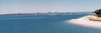
. Bribie island, hugging the coastline and tapering to a long spit at its most northern point near Caloundra, is separated from the mainland by the Pumicestone Passage
Pumicestone Passage
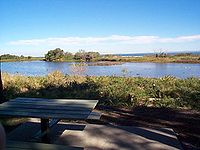
Pumicestone Passage, also known as the Pumicestone Channel, is a narrow waterway between Bribie Island and the mainland in Queensland, Australia...
. A bridge from Sandstone Point on the mainland was completed in 1963. The ocean side of the island is somewhat sheltered from prevailing winds by Moreton Island and associated sand banks and has only a small surf break. The lee side is calm, with white sandy beaches in the south.
Most of the island is uninhabited national park (55.8 square kilometres) and forestry plantations. The southern end of the island has been intensively urbanised as part of the Moreton Bay Region, the main suburbs being Bongaree, Woorim, Bellara and Banksia Beach. Buckley's Hole, at the southern tip of the island, is an important bird habitat and refuge.
Suburbs
Crossing to the island from the mainland via the bridge, the first suburb to be encountered is BellaraBellara, Queensland
Bellara is a suburb of the Moreton Bay Region in Queensland, Australia. It is located on the western side of Bribie Island, adjacent to the Pumicestone Passage. At the 2006 census, the suburb recorded a population of 2,962 persons, with a median age of 51 years.....
. The other three major suburbs are Woorim
Woorim, Queensland
Woorim is a suburb of the Moreton Bay Region in Queensland, Australia. It is located on the eastern or ocean side of Bribie Island, adjacent to the Pacific Ocean. At the 2006 census, the suburb recorded a population of 1,638 persons, with a median age of 53 years..Woorim is the location of the...
(about 5 km away on the island's 'surf side'), Bongaree
Bongaree, Queensland
Bongaree is a suburb of the Moreton Bay Region in Queensland, Australia. It is located on the western side of Bribie Island, adjacent to the Pumicestone Passage. At the 2006 census, the suburb recorded a population of 14,275 persons, with a median age of 55 years..The suburb is named after the...
at the southern end of the island, on the 'calm side' or 'passage side' and Banksia Beach
Banksia Beach, Queensland
Banksia Beach is a suburb on Bribie Island, approximately 49 km north of Brisbane, the state capital of Queensland, Australia. Its Local Government Area is Moreton Bay RegionThe name refers to the plant genus banksia, which grows in the area....
and White Patch at the northern end of the populated area, also on the 'passage side'. Another suburb, Welsby, exists on maps; however there is currently no development in this area.
Transport
Bribie Island Coaches operates a bus service around the Island as well as a route which runs to CabooltureCaboolture, Queensland
Caboolture is an urban centre approximately north of Brisbane, the state capital of Queensland, Australia. Caboolture is considered to be the northernmost urban area of the greater Brisbane metropolitan region within South East Queensland, and it marks the end of the Brisbane suburban commuter...
and Morayfield
Morayfield
Morayfield is a suburb of Caboolture, 44 km north of Brisbane, the state capital of Queensland, Australia. Its Local Government Area is the Moreton Bay Region....
via Ningi and Pebble Beach. In August 2007 an alternative route, via Beachmere and Pebble Beach, was introduced. The service to Caboolture is timed to connect with trains to and from Brisbane.
Protected areas
Bribie Island National Park
Bribie Island is a national park in Queensland, Australia, 68 km north of Brisbane. The park covers approximately one third of Bribie Island...
covers 55.8 km², nearly a third of the total area of the island. There is a common misconception that the national park covers most of the non-inhabited area, but in fact most of the centre of the island consists of conifer plantations closed to public access. Formerly leased to CSR Timber, the Queensland Government is currently re-planting around 25 km² of this area through its DPI Forestry arm. Much of the rest has been developed for housing. Buckley's Hole, at the southern tip of the island, was declared an environmental park in 1992. More than 350 species of birds live in or visit the area.
In 2009 the Queenslands National Parks and Wildlife Service (QNPWS) used imported blocks of rock to prevent access to roads and tracks leading into the national park forcing all vehicle access to the park to be via the Beach Access Track at Woorim or the Ranger Station at Whitepatch. All access to the national park now requires a permit to be purchased. Local residents were threatened by letter with fines of up to $16,000 by QNPWS in 2009 for walking domestic animals within the park.
Pumicestone Passage
Pumicestone Passage
Pumicestone Passage, also known as the Pumicestone Channel, is a narrow waterway between Bribie Island and the mainland in Queensland, Australia...
, which is located between the island and the mainland is a protected marine park that provides habitat for dugongs, turtles and dolphins. There are also extensive mangroves forests in this area. Eucalypt forests, banksias and heathlands are the predominant vegetation elsewhere. Bribie Island is home to around 350 species of bird. This includes a range of honeyeater species, loirkeets, waterbirds and birds of prey.
Pre-European contact
The inhabitants of Bribie Island at the time they were encountered by Matthew FlindersMatthew Flinders
Captain Matthew Flinders RN was one of the most successful navigators and cartographers of his age. In a career that spanned just over twenty years, he sailed with Captain William Bligh, circumnavigated Australia and encouraged the use of that name for the continent, which had previously been...
in H.M. colonial sloop Norfolk
Norfolk (sloop)
The Colonial sloop Norfolk: “The necessity of a vessel to keep up a more frequent intercourse with Norfolk Island, …having been much felt by the want of various stores …occasioned Captain Townson, the Commanding officer, to construct a small decked boat, sloop rigged, in which he sent His letters...
in 1799 were broadly part of the Kabi
Kabi
The Kabi people are an Aboriginal Goori people of Australia, and corresponding language group of the South East Queensland coast, stretching from Brisbane up to Bundaberg. In their language, "Kabi" means "No"....
Gubbi Gubbi people of South-East Queensland. Colliver and Woolston record the Bribie tribes as being called Djindubari by Tindale and Jindoobarria by Meston.
Meston recorded the pre-contact population of Aboriginal people as 600-1,000, but by 1891 none remained on the Island and only four lived on the mainland.
Joondaburri lifestyle
The comparatively rich coastal country allowed permanent residence. Natural resources of land and sea were abundant and harvested according to the seasons. Winter mullet schooled from May to July. Dolphins were trained to herd the fish into waiting nets and spears. Winter was the best season for bream, followed by tailor in September and October. In summer mud crabs and oysters were plentiful and dugong were hunted. Summer whiting and flathead were speared or netted. Bungwall Fern was gathered for its starchy roots all year round. Kangaroo, eels and carpet snakes were rich in protein and fat. The dominant shellfish used as food was the oyster known today as the Sydney Rock OysterSydney rock oyster
The Sydney rock oyster, Saccostrea glomerata, formerly known as Saccostrea commercialis, is an oyster species endemic to Australia and New Zealand...
known locally as tibir, at that time growing naturally on the seabeds. The oyster middens, many metres thick, were plundered by early settlers for lime. A significant midden site, now lost, was located not far from Bongaree jetty. It contained discarded shells, marsupial bones and stone tools. The biggest of the oyster middens was at White Patch, where dugong were also plentiful. The Ugari (pipi)
Plebidonax deltoides
Plebidonax deltoides, known as pipi in the eastern Australian states, and Goolwa cockle in South Australia, is a small, edible saltwater clam or marine bivalve mollusc of the family Donacidae, endemic to Australia. It was previously known as Donax deltoides...
on the coastal beaches was also eaten.
James Cook, 1770
Lieutenant James CookJames Cook
Captain James Cook, FRS, RN was a British explorer, navigator and cartographer who ultimately rose to the rank of captain in the Royal Navy...
sighted the Glass House Mountains west of the Island on Thursday 17 May 1770 while sailing up the east coast of Australia in HM Bark Endeavour
HM Bark Endeavour
HMS Endeavour, also known as HM Bark Endeavour, was a British Royal Navy research vessel commanded by Lieutenant James Cook on his first voyage of discovery, to Australia and New Zealand from 1769 to 1771....
. He called these hills the Glass Houses as the reflections and the shape of the hills reminded him of the glass manufacturing houses back in England. James Cook
James Cook
Captain James Cook, FRS, RN was a British explorer, navigator and cartographer who ultimately rose to the rank of captain in the Royal Navy...
named the area Glass House Bay and was the first European to name this stretch of water.
Matthew Flinders, 1799
On 16 July 1799 Captain Matthew Flinders left Glass House Bay about two miles east of the shore in the Norfolk. He sailed south-west between Moreton Island and the mainland parallel to the southern shore of Bribie Island until spotting an opening in the low western shore. He anchored at 8:15am and transferred with a small crew and BongareeBungaree
Bungaree was an Aboriginal Australian from the Broken Bay area, who was known as an explorer, entertainer, and Aboriginal community leader He became a familiar sight in colonial Sydney, dressed in a succession of military and naval uniforms that had been given to him...
to a smaller craft. He landed on Bribie Island unaware that it wasn't the mainland and met a small group of Aborigines who had gathered on the beach. Although Bongaree didn't speak the same dialect as the local aborigines the meeting was peaceful until one attempted to remove Flinders' hat. Flinders refused and the Europeans and Bongaree returned to their boat. As they left the man who had tried to remove Flinders' hat threw a spear that missed the small boat and crew. Flinders fired his musket at the men on shore and wounded the man who had thrown the spear. The Aborigines fled the beach. Flinders named the southern shore and site of the confrontation Point Skirmish. There is an area on the modern map marked Skirmish Point but should not be confused with the actual place of the incident which is known as South Point.
Flinders needed to repair leaks in his boat and pulled it ashore some five miles north of the area he had the incident with the locals for those repairs. Once his boat was repaired he explored the mainland side of the passage and scaled Mt. Beerburrum to get a view of the area. He spent 15 days in the region.
It was not until some time later it was determined that this was an island and the changing of the name of the waterway between Bribie Island and the mainland was made at some other point.
Bribie in World War II
In February 1939, six months before the start of WW2, a review of the defences of Moreton Bay called for two 6 inch Mark XI guns at north Bribie.
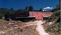
Soon after Australia declared war on Germany on 3 September 1939, 6 inch guns previously carried by the World War I-era cruiser were taken to the present location of Fort Bribie http://www.nearmap.com/?ll=-26.859763,153.129656&z=20&t=h&nmd=20110501|map to guard the northwest channel, which ran close to the shore near Caloundra, across the bay in a southeasterly direction towards Moreton Island, and then southwesterly towards the mouth of the river, forming a Z-shaped route. The most effective sites for guns were the closest points to the channel bends.
The mounting and placement of the guns was hopelessly inadequate and according to Major General Robert E Jackson, Officer in Charge of Northern Command in July 1940, Fort Bribie was "no value from a defence point of view" and had to be fixed.
Before this could happen an argument about the location broke out, costings being sought for both Bribie and Caloundra. It was argued Caloundra was higher, better equipped and cheaper to build, whereas Bribie was flat, hot, infested with mosquitos and sandflies, had no freshwater, no bridge and would be much more expensive. The decision came down to Fort Bribie's ability to cover both entrances to the northwest channel, while Caloundra could only cover the most northerly entrance. The guns had a range of about 19 kilometres.
Colonel J S Whitelaw designed the layout of the fort on Bribie and recommended its completion, receiving the go ahead by early 1942. By April — hastened by the December 1941 attacks by the Japanese forces on Pearl Harbour, Malaya, Hong Kong and Singapore — construction of the gun emplacements was almost complete. The construction cost of all of Fort Bribie's concrete structures was ₤55,000, about $2.5 million in 2010 dollars.
On February 19, 1942, Darwin was bombed in two raids killing at least 243 people and wounding between 300 and 400 more. By November 1943 Darwin was bombed 64 times, with other towns also attacked including Townsville. The ferocity and success of the attacks suddenly created a very real dread in the Queensland population.
In July 1942 after failing to take Port Moresby by sea in the Battle of the Coral Sea, the Japanese landed on Papua New Guinea's north coast and moved south, capturing Kokoda on 29 July. This was the first time any Australian territory had been occupied by an enemy force.
Reinforcements were sent to Fort Bribie and Fort Cowan Cowan, strengthening the existing defences at the two forts. A number of 155mm guns from the First World War were provided to upgrade Australian coastal defences, and new forts were constructed during 1942-43 at Skirmish Point on south Bribie Island and Rous on Moreton Island. The Skirmish Point Battery at Woorim contained two fixed 155 mm gun emplacements on Panama mounts.
The Pacific War also brought the Americans soldiers. Brisbane during the Second World War
It was widely believed at the time that the American and Australian armed forces and governments had conspired on a plan to abandon Australia north of Brisbane to the Japanese in case of invasion. The plan, known as the Brisbane Line
Brisbane Line
The "Brisbane Line" was a controversial defence proposal allegedly formulated during World War II to concede the northern portion of the Australian continent in the event of an invasion by the Japanese...
was never official policy, but the alleged strategy gained support after General Douglas MacArthur referred to it during a press conference in March 1943, where he also coined the term 'Brisbane Line'.
Many historians of the WW2 period on Bribie island refer to Brisbane Line and draw it from Fort Bribie due west to Charleville, then south-west to a point just west of Adelaide, as recounted by Warwick Outram in Bribie Memories 2nd edition 2009 ISBN 9780975197141. George H. Johnston, War Correspondent for the Argus newspaper was present when MacArthur mentioned the Brisbane Line on 16 March 1943, but later clarified the matter by writing It was Gen. MacArthur who abandoned the Brisbane Line concept and decided that the battle for Australia should be fought in New Guinea.
At Fort Bribie itself, two mine control huts were used by Royal Australian Navy during 1942 and 1943, known as RAN 2. These monitored and controlled the guard indicator loops and mine loops set in the North West Channel. The indicator loops relied on a moving magnet or any large mass of metal, which naturally acquires magnetic force, to induce a current in a stationary loop of wire. If a submarine was detected by the guard loop, the operator would wait until there was also a swing mine loop before detonating the mines by sending a current down the mine loop. RAN 2 was moved to Cowan Cowan on Moreton Island in September 1943. When the mines in Moreton Bay were decommission at the end of the war, six were missing. One was found at Tewantin in 1945.
The mines weighed 1430 kg and were buoyant, so needed to be moored with sinkers, up to 25 metres below the surface. Every 5 minutes hour perturbations due to the tides known as perts had to be recorded. Daily and weekly tests were carried out on all equipment. In three years of operation, the mines were never detonated.
Another minefield with guard loop built in 1942 protected Pearl Channel and Main Channel south of Bribie Island. The guard loops ran from the Loop Control Hut at the end of North Street, just north of Woorim to Combouyuro Point, Moreton Island. Three Harbour Defence Asdics, sea-bed mounted submarine detection devices now known as sonar, were position down-channel from the guard loops, as a second means of detection.
Politics and people
Carryn Sullivan is the member for Pumicestone which includes Bribie Island within its electoral boundaries (2010) while the current Division 1 councillor is Gary Parsons (2010). Federally, Bribie Island is contained within the Division of LongmanLongman
Longman was a publishing company founded in London, England in 1724. It is now an imprint of Pearson Education.-Beginnings:The Longman company was founded by Thomas Longman , the son of Ezekiel Longman , a gentleman of Bristol. Thomas was apprenticed in 1716 to John Osborn, a London bookseller, and...
which since 2010 has been represented by Wyatt Roy MP
Wyatt Roy
Wyatt Beau Roy is an Australian politician. He has been a Liberal National Party of Queensland member of the Australian House of Representatives since August 2010, representing the electorate of Longman. At 20 years of age, he was the youngest person ever to be elected to an Australian parliament...
The artist Ian Fairweather
Ian Fairweather
Ian Fairweather was an Australian painter. Fairweather was born in Scotland in 1891 and arrived in Melbourne in February 1934...
lived on Bribie Island for many years in great poverty. There are many types of wildlife present on the island. Kangaroos, wallabies, emus, various snake species, green tree frogs and dingos can often be seen venturing from the national park into the surrounding suburbs.
Retail and entertainment facilities
ALDI
ALDI Einkauf GmbH & Co. oHG, doing business as ', short for "Albrecht Discount", is a discount supermarket chain based in Germany...
store and two large IGA supermarkets located at Bongaree and Banksia Beach. Traditional "strip" development of shopping facilities around the island provides a comprehensive array of retail businesses such as hardware stores, medical centres, newsagents, chemists and food outlets.
There are two large, modern hotels - The Bribie Island Hotel at Bellara and the Blue Pacific Hotel on the 'surf side' of the island at Woorim. Residents and visitors often prefer to visit local clubs such as the large and award-winning Bribie Island Citizens and RSL Club, the two bowls clubs at Bongaree, the Surf Life Saving Club at Woorim on the 'surf side', and the small Solander Lakes Bowls Club at Banksia Beach. There is a well established golf club at Woorim, with a second golf course and club house recently completed at Banksia Beach as part of the Pacific Harbour development. A small twin cinema was established in 2001 on McMahon Street.
Desalination plant
A desalination plant has been proposed for Bribie Island by the current Labor government. The plant will be located in state forest away from populated areas and has passed an environmental impact study. Some residents are opposed to the plant due to environmental reasons. Others see the plant as a benefit to the island. This project would also allow for a new bridge to be constructed for the transport of materials. A new bridge is needed due to population growth in the area. Bribie Island Chamber of Commerce president Rhonda Cockinos has stated that the existing two lane bridge is inadequate due to increasing traffic volumes and poses a safety risk if it is blocked, for example, after a traffic accident.Schools
There are two primary schools: Bribie Island State School at Bongaree, and Banksia Beach State School. Bribie Island State School was opened on 4 February 1924. Prior to the opening of the Bribie Island State High School in 1989 secondary students were transported to Caboolture. The 2006 enrolment at the high school was 954 students. Bribie Island State High School presently has over 1,000 students. Banksia Beach State School's student numbers are continuing to rise annually and are now over 1,000 students.Demographics
According to the Australian Bureau of StatisticsAustralian Bureau of Statistics
The Australian Bureau of Statistics is Australia's national statistical agency. It was created as the Commonwealth Bureau of Census and Statistics on 8 December 1905, when the Census and Statistics Act 1905 was given Royal assent. It had its beginnings in section 51 of the Constitution of Australia...
there were 16,209 persons resident on the island in 2006. Of these, 7796 (48%) were males and 8413 (52%) were females. Of the total population 1.6% were Indigenous persons compared with 2.3% for all of Australia.
13.6% of the population on the island were children aged between 0–14 years and 50.3% were persons aged 55 years and over. The median age of persons was 55 years, compared with 37 years for all of Australia. 75.7% stated they were born in Australia. Other places of birth included were: England 6.6%, New Zealand 4.0%, Germany 0.9%, Netherlands 0.8% and Scotland 0.8%. The median weekly household income was $609, compared with $1,027 for all of Australia.
Cultural references
In 2004 a reality television series called The Hot HouseThe Hot House
The Hot House was an Australian reality television series that aired on the Network Ten in 2004. It was hosted by Erika Heynatz.The show featured couples working together to build a dream home on the Queensland's Bribie Island and competed against each other to avoid being eliminated every week...
that aired on Network Ten
Network Ten
Network Ten , is one of Australia's three major commercial television networks. Owned-and-operated stations can be found in Sydney, Melbourne, Brisbane, Adelaide and Perth, while affiliates extend the network to cover most of the country...
was filmed on Bribie Island. The show entailed 14 couples building a house together knowing that only one couple would win the house and a number of prizes, including a boat, which came with it. On the final night of filming locals were given free tickets to enter the area which had been fenced off for filming.
In popular fiction
Fictional books that are set wholly or partly on Bribie Island include The Enigmatic Mr Phelps, by Canada-based English international crime writer David B. Green, was partly set in Banksia Beach during the winter of 2004. It includes many references to the island and the surrounding area. Part two of the two-part novel, Berlin by Christmas, features an opening chapter based entirely on the island. The fictional character of "Phelps" is often confused with the real life of the author.See also
- List of islands of Queensland
- Bribie Island Seaside MuseumBribie Island Seaside MuseumBribie Island Seaside Museum opened on 14 May 2010 at 1 South Esplanade, Bongaree, on the Pumicestone Passage side of Bribie Island, Moreton Bay Region in Queensland, Australia...
External links
- Statistical information
- University of Queensland: Queensland Places: Bribie Island
- Video: A walk on Bribie Island A digital story by David Crane created as part of the Queensland Stories project, State Library of Queensland.