
Ward, Colorado
Encyclopedia
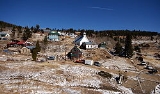
Ward is a Home Rule Municipality in Boulder County
, Colorado
, United States
. The population was 150 at the 2010 census
. The town is a former mining settlement founded in 1860 in the wake of the discovery of gold
at nearby Gold Hill
. Once one of the richest towns in the state during the Colorado Gold Rush
, it is located on a mountainside at the top of Left Hand Canyon, near the Peak-to-Peak Highway (State Highway 72
) northwest of Boulder
.
a claim in 1860 on the site known as Miser's Dream. The town boomed the following year with the discovery by Cyrus W. Deardorff of the Columbia vein. Over the next several decades the population fluctuated, growing from several hundred to several thousand before declining once again. The mines in the area remained profitable for many decades, with one mine eventually producing over 2 million ounces (62 metric tons) of silver
. A post office
with the name Ward District was established January 13, 1863; the name was changed to Ward, September 11, 1894. The city was incorporated in June 1896. The railroad reached the area in 1898, arriving over the Whiplash and Switzerland Trail, which climbed over 4,000 feet (1,220 m) from Boulder over the course of 26 miles (41.8 km). In 1901 over 50 buildings were destroyed by a devastating fire, although the profitability of the mines led to the immediate rebuilding of the town. The town was largely deserted by the 1920s, but the construction of the Peak-to-Peak Highway in the 1930s led to a revival of the town. During WWII the town's year-round population dropped to four people. Then, in the 1960s, the town's population jumped from between 10-20 year-round residents to well over 100 due to the town's interest to hippies.
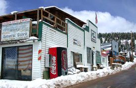
The town has several businesses along its main street, including a restaurant, a coffee shop and general store.
According to the United States Census Bureau
, the town has a total area of 0.6 square miles (1.6 km²), all of it land.
of 2010, there were 150 people, 75 households, and 36 families residing in the town. The population density
was 296.9 people per square mile (114.5/km²). There were 82 housing units at an average density of 144.1 per square mile (55.5/km²). The racial makeup of the town was 98.82% White, and 1.18% from two or more races.
 There were 75 households out of which 26.7% had children under the age of 18 living with them, 34.7% were married couples
living together, 5.3% had a female householder with no husband present, and 52% were non-families. 37.3% of all households were made up of individuals and 8% had someone living alone who was 65 years of age or older. The average household size was 2 and the average family size was 2.67.
In the town the population was spread out with 19.3% under the age of 18, 5.3% from 18 to 24, 32% from 25 to 44, 35.3% from 45 to 64, and 8% who were 65 years of age or older. The median age was 43.5 years. For every 100 females there were 154.2 males. For every 100 females age 18 and over, there were 132.7 males.
In 2000, the median income for a household in the town was $33,750, and the median income for a family was $50,313. Males had a median income of $26,250 versus $28,750 for females. The per capita income
for the town was $14,900. None of the population or families were below the poverty line.
Boulder County, Colorado
Boulder County is the sixth most populous of the 64 counties of the state of Colorado of the United States. The county seat is Boulder. The most populous municipality in the county and the county seat is the City of Boulder...
, Colorado
Colorado
Colorado is a U.S. state that encompasses much of the Rocky Mountains as well as the northeastern portion of the Colorado Plateau and the western edge of the Great Plains...
, United States
United States
The United States of America is a federal constitutional republic comprising fifty states and a federal district...
. The population was 150 at the 2010 census
United States Census, 2010
The Twenty-third United States Census, known as Census 2010 or the 2010 Census, is the current national census of the United States. National Census Day was April 1, 2010 and is the reference date used in enumerating individuals...
. The town is a former mining settlement founded in 1860 in the wake of the discovery of gold
Gold
Gold is a chemical element with the symbol Au and an atomic number of 79. Gold is a dense, soft, shiny, malleable and ductile metal. Pure gold has a bright yellow color and luster traditionally considered attractive, which it maintains without oxidizing in air or water. Chemically, gold is a...
at nearby Gold Hill
Gold Hill, Colorado
Gold Hill is a census-designated place in Boulder County, Colorado, United States. The population was 230 at the 2010 census.This settlement is located to the northwest of Boulder, perched on a mountainside above Left Hand Canyon at an elevation of 8,300 feet...
. Once one of the richest towns in the state during the Colorado Gold Rush
Colorado Gold Rush
The Pike's Peak Gold Rush was the boom in gold prospecting and mining in the Pike's Peak Country of western Kansas Territory and southwestern Nebraska Territory of the United States that began in July 1858 and lasted until roughly the creation of the Colorado Territory on February 28, 1861...
, it is located on a mountainside at the top of Left Hand Canyon, near the Peak-to-Peak Highway (State Highway 72
Colorado State Highway 72
State Highway 72 is a long state highway passing through the foothills and the eastern edge of the Front Range.-Route description:The route is a mainly rural, scenic, mountainous highway; not having many junctions. It begins at I-70 in Wheat Ridge as Ward Road. It continues north through the...
) northwest of Boulder
Boulder, Colorado
Boulder is the county seat and most populous city of Boulder County and the 11th most populous city in the U.S. state of Colorado. Boulder is located at the base of the foothills of the Rocky Mountains at an elevation of...
.
History
The town was named for Calvin Ward, who prospectedProspecting
Prospecting is the physical search for minerals, fossils, precious metals or mineral specimens, and is also known as fossicking.Prospecting is a small-scale form of mineral exploration which is an organised, large scale effort undertaken by mineral resource companies to find commercially viable ore...
a claim in 1860 on the site known as Miser's Dream. The town boomed the following year with the discovery by Cyrus W. Deardorff of the Columbia vein. Over the next several decades the population fluctuated, growing from several hundred to several thousand before declining once again. The mines in the area remained profitable for many decades, with one mine eventually producing over 2 million ounces (62 metric tons) of silver
Silver
Silver is a metallic chemical element with the chemical symbol Ag and atomic number 47. A soft, white, lustrous transition metal, it has the highest electrical conductivity of any element and the highest thermal conductivity of any metal...
. A post office
Post office
A post office is a facility forming part of a postal system for the posting, receipt, sorting, handling, transmission or delivery of mail.Post offices offer mail-related services such as post office boxes, postage and packaging supplies...
with the name Ward District was established January 13, 1863; the name was changed to Ward, September 11, 1894. The city was incorporated in June 1896. The railroad reached the area in 1898, arriving over the Whiplash and Switzerland Trail, which climbed over 4,000 feet (1,220 m) from Boulder over the course of 26 miles (41.8 km). In 1901 over 50 buildings were destroyed by a devastating fire, although the profitability of the mines led to the immediate rebuilding of the town. The town was largely deserted by the 1920s, but the construction of the Peak-to-Peak Highway in the 1930s led to a revival of the town. During WWII the town's year-round population dropped to four people. Then, in the 1960s, the town's population jumped from between 10-20 year-round residents to well over 100 due to the town's interest to hippies.
The town has several businesses along its main street, including a restaurant, a coffee shop and general store.
Geography
Ward is located at 40°4′20"N 105°30′36"W (40.072347, -105.510131).According to the United States Census Bureau
United States Census Bureau
The United States Census Bureau is the government agency that is responsible for the United States Census. It also gathers other national demographic and economic data...
, the town has a total area of 0.6 square miles (1.6 km²), all of it land.
Demographics
As of the censusCensus
A census is the procedure of systematically acquiring and recording information about the members of a given population. It is a regularly occurring and official count of a particular population. The term is used mostly in connection with national population and housing censuses; other common...
of 2010, there were 150 people, 75 households, and 36 families residing in the town. The population density
Population density
Population density is a measurement of population per unit area or unit volume. It is frequently applied to living organisms, and particularly to humans...
was 296.9 people per square mile (114.5/km²). There were 82 housing units at an average density of 144.1 per square mile (55.5/km²). The racial makeup of the town was 98.82% White, and 1.18% from two or more races.
Marriage
Marriage is a social union or legal contract between people that creates kinship. It is an institution in which interpersonal relationships, usually intimate and sexual, are acknowledged in a variety of ways, depending on the culture or subculture in which it is found...
living together, 5.3% had a female householder with no husband present, and 52% were non-families. 37.3% of all households were made up of individuals and 8% had someone living alone who was 65 years of age or older. The average household size was 2 and the average family size was 2.67.
In the town the population was spread out with 19.3% under the age of 18, 5.3% from 18 to 24, 32% from 25 to 44, 35.3% from 45 to 64, and 8% who were 65 years of age or older. The median age was 43.5 years. For every 100 females there were 154.2 males. For every 100 females age 18 and over, there were 132.7 males.
In 2000, the median income for a household in the town was $33,750, and the median income for a family was $50,313. Males had a median income of $26,250 versus $28,750 for females. The per capita income
Per capita income
Per capita income or income per person is a measure of mean income within an economic aggregate, such as a country or city. It is calculated by taking a measure of all sources of income in the aggregate and dividing it by the total population...
for the town was $14,900. None of the population or families were below the poverty line.
See also
- Colorado cities and towns
- Colorado municipalitiesColorado municipalitiesThe U.S. state of Colorado currently has 271 active incorporated municipalities, including 196 towns, 73 cities, and two consolidated city and county governments.-Municipal government:...
- Colorado municipalities
- Colorado metropolitan areasColorado metropolitan areasThe metropolitan areas of the State of Colorado include the urban statistical areas defined by the United States Office of Management and Budget and regions of urban population defined by other organizations.-Census statistical areas:...
- Boulder Metropolitan Statistical Area
- Denver-Aurora-Boulder Combined Statistical AreaDenver-Aurora-Boulder Combined Statistical Areathumb|300px|Map of the 12-county Denver-Aurora-Boulder Combined Statistical AreaThe Denver-Aurora-Boulder, CO Combined Statistical Area is a United States Census Bureau defined Combined Statistical Area located in the Denver region of the state of Colorado...
- North Central Colorado Urban AreaNorth Central Colorado Urban Areathumb|240px|An enlargeable map of the 13-county North Central Colorado Urban AreaThe North Central Colorado Urban Area comprises the four contiguous metropolitan statistical areas in the north central region of the State of Colorado: the Denver-Aurora Metropolitan Statistical Area, the Boulder...
- Front Range Urban CorridorFront Range Urban CorridorThe Front Range Urban Corridor is an oblong region of urban population located along the eastern face of the Southern Rocky Mountains in the U.S. states of Colorado and Wyoming. The corridor derives its name from the Front Range, the mountain range that defines the west central boundary of the...
- Roosevelt National ForestRoosevelt National ForestThe Roosevelt National Forest is a National Forest located in north central Colorado. It is contiguous with the Colorado State Forest as well as the Arapaho National Forest...