
Lyons, Colorado
Encyclopedia
Lyons is a Statutory Town in Boulder County
, Colorado
, United States
. The population was 1,585 at the 2000 census
. Lyons is located at the confluence of the North St. Vrain Creek
and the South St. Vrain Creek, twenty miles (32 km) east of Rocky Mountain National Park
. Due to its location at the intersection of State Highway 7
and U.S. Highway 36 which lead to Rocky Mountain National Park
, it is sometimes referred to as The Double Gateway to the Rockies.
According to the United States Census Bureau
, the town has a total area of 1.2 square miles (3.1 km²), all of it land.
In the 1860s, families came from eastern United States and settled the foothills with their ranches and farms. The town of Lyons, Colorado was founded in 1880 by Edward S. Lyon. He purchased 160 acre (0.6474976 km²) from H.F. and Isabelle Sawyer, noticing the potential to quarry out the red sandstone
, outcroppings which offered easy quarrying access in the region. Lyon plat
ted the town in 1881; it was incorporated in 1891. No record survives to account for the added "s" at the end of the town's name.
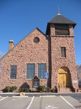
The first main building to be built was the red sandstone schoolhouse in 1881. The booming population resulted in the town adding a second floor a few years later. It was also used for church and town meetings, until 1894 when the Old Stone Church was built. In 1979, it was saved from demolition and converted into the town's history museum by the Lyons Historical Society, Lyons Redstone Museum
The town has large red sandstone mountains on three sides. Its rock, from the Permian Period, about 260 million years ago, is considered the hardest sandstone in the world, and has a unique red or salmon color. While E. S. Lyon established the quarrying business in the town, his business was not a big success, and he left for California. Numerous owners succeeded him and developed various successful quarries over time. Murphy, Brodie, Ohline, Loukonen and Vasquez are among the most noteworthy owners. A railroad built to the town in the late 19th century gave the quarries a significant boost.
In 1910-12 the cement industry killed the sandstone industry, and rock production stopped. The only sandstone construction that went on during this period was the University of Colorado
new unified campus. The sandstone business was revived in the 1930s when the red sandstone started to be used more as a decorative rock than for commercial purposes. Today it is a booming industry, with sandstone shipped worldwide.
. These were all constructed of native stone by master craftsmen between the early 1870s and 1917. They include commercial, residential and public buildings:
The Lyons Redstone Museum is open June 1 to October 1, seven days a week. It was dedicated in 1979. It is free and open to the public on a donation basis. Its director is LaVern Johnson. The first floor has historic displays (including an old bank teller cage, re-created living room and kitchen area, quarry and small farm equipment, musical instruments, dairy equipment, and more). It has arrowhead and electric insulator collections. The first-floor work area contains the town's history archives (mainly newspaper clippings), video interviews and documentaries of its pioneer families, and a small gift and book shop. Books for sale include multiple history books of the area, and hundreds of used books from 1900 to today.
The second floor has some displays, (like ice cream parlor booths) but mainly it has dozens of archival black and white photographs of early Lyons, from 1880s to 1940s. Along the walls are all of the Lyons High School graduation photos, beginning in the 1930s. Since the 1881 building did not open as a museum until the 1970s, some of the records are incomplete regarding early town history; but it is extensively covered by the locally produced books and dvd documentaries. it is located at 412 High St, Lyons, Colorado 80540; (303) 823-5271.
Lyons Arts and Humanities Council is an instrumental group in helping to promote art in downtown Lyons, and its artists' works. There are several pieces of permanent public art, including sculptures made of local sandstone, such as giant eggs, flower containers, a fountain, a small performance stage, and more.
In 2008 and 2009, the town renovated its two main streets to include sandstone sidewalks and features, floral decorations, seating areas and sculptures. It won the Governor's Award for Downtown Excellence .
As a public community art project, a mural depicting life in Lyons, called Lyons Past, Present and Future, was placed on the outdoor wall of the Visitor Center in June 2003. At that time, the group gave itself the name Confluence Community Arts (CoCoA) . It is mainly run by Cathy Rivers and Priscalla Cohan, who have gone on to start a second project, call The Clarifier Project which involves the communitiy painting tiles to decorate the old circular cement building next to the St. Vrain River.
Notable cultural arts residents include: artist Barbara Stone
, poet George Moore , author Ann Ripley, writer/photographer Kathleen Spring and sculptors John King
and Bruce Campbell who reside in the Lyons area.
festival, and the Folks Festival folk music
festival. It draws people from across the nation because of its nationally-known lineup and its general seating in open grassy treed grounds, at the base of a red sandstone mountain and the St. Vrain River. In addition to a new stage for the festivals in recent years, they have built the Sunflower covered-pavillion which allows for smaller year-round concerts by single musicians.
The Sounds of Lyons concert series began in 2009, bringing in highly acclaimed classically-trained musicians, including founder MinTze Wu, to perform over one weekend in spring. High Street Concerts began in 2001 and concerts take place during the winter months bringing national and local acoustic and Americana acts. The volunteer-run concert series was founded by KC Groves, Sam Tallent, and Mike Whipp. In addition, there are sporadic community concerts and dances throughout the year, including weekly summer concerts in Sandstone park and occasionally at Lyons High School. The Red Rock Ramblers, founded by the LaVern Johnson family, began square dancing in Lyons in 1958 and offer dances every Saturday during the summer.
. Lyons is also bordered by both Hall Ranch Open Space and Heil Valley Ranch Open Space. Hall Ranch provides over 12 miles (19 km) of multi-use trails and consists of 3206 acres (13 km²) of back country. Heil Valley Ranch consists of 4923 acres (20 km²) of back country. Trails are open to hikers, mountain bikers and equestrians. Picture Rock Trail was opened on September 22, 2008 connecting Heil Valley Ranch trails to Lyons and to Hall Ranch trails. Picture Rock is 5.5 miles (9 km) and well designed and built by volunteers. The north end of Picture Rock is at Red Gulch Rd, then Old St Vrain Rd and Hwy 7 lead to the Hall Ranch Trailhead or Lyons. The south end of Picture Rock is 4.5 miles (7 km) from the Heil Ranch Trailhead off Lefthand Canyon.
of 2000, there were 1,585 people, 672 households, and 436 families residing in the town. The population density
was 1,273.5 people per square mile (493.5/km²). There were 686 housing units at an average density of 551.2 per square mile (213.6/km²). The racial makeup of the town was 92.49% White, 0.38% African American, 0.88% Native American, 0.69% Asian, 4.23% from other races
, and 1.32% from two or more races. Hispanic or Latino of any race were 8.01% of the population.
There were 672 households out of which 33.8% had children under the age of 18 living with them, 49.3% were married couples
living together, 11.5% had a female householder with no husband present, and 35.1% were non-families. 25.7% of all households were made up of individuals and 5.4% had someone living alone who was 65 years of age or older. The average household size was 2.36 and the average family size was 2.85.
In the town the population was spread out with 24.0% under the age of 18, 6.9% from 18 to 24, 36.3% from 25 to 44, 26.8% from 45 to 64, and 6.1% who were 65 years of age or older. The median age was 38 years. For every 100 females there were 101.4 males. For every 100 females age 18 and over, there were 101.8 males.
The median income for a household in the town was $50,764, and the median income for a family was $58,750. Males had a median income of $45,417 versus $29,750 for females. The per capita income
for the town was $28,276. About 6.6% of families and 8.3% of the population were below the poverty line, including 12.2% of those under age 18 and 2.3% of those age 65 or over.
Boulder County, Colorado
Boulder County is the sixth most populous of the 64 counties of the state of Colorado of the United States. The county seat is Boulder. The most populous municipality in the county and the county seat is the City of Boulder...
, Colorado
Colorado
Colorado is a U.S. state that encompasses much of the Rocky Mountains as well as the northeastern portion of the Colorado Plateau and the western edge of the Great Plains...
, United States
United States
The United States of America is a federal constitutional republic comprising fifty states and a federal district...
. The population was 1,585 at the 2000 census
United States Census, 2000
The Twenty-second United States Census, known as Census 2000 and conducted by the Census Bureau, determined the resident population of the United States on April 1, 2000, to be 281,421,906, an increase of 13.2% over the 248,709,873 persons enumerated during the 1990 Census...
. Lyons is located at the confluence of the North St. Vrain Creek
St. Vrain Creek
St. Vrain Creek is a tributary of the South Platte River, approximately long, in north central Colorado in the United States. It drains part of the foothills north of Boulder and the Colorado Piedmont area in the vicinity of Longmont.The creek is formed by the confluence of North and South St....
and the South St. Vrain Creek, twenty miles (32 km) east of Rocky Mountain National Park
Rocky Mountain National Park
Rocky Mountain National Park is a national park located in the north-central region of the U.S. state of Colorado.It features majestic mountain views, a variety of wildlife, varied climates and environments—from wooded forests to mountain tundra—and easy access to back-country trails...
. Due to its location at the intersection of State Highway 7
Colorado State Highway 7
State Highway 7 in the U.S. state of Colorado is a state highway. Approximately long, it is located in the north-central portion of the state, traversing the mountains on the east of the continental divide south of Estes Park as well as portions of the Colorado Piedmont north of Denver...
and U.S. Highway 36 which lead to Rocky Mountain National Park
Rocky Mountain National Park
Rocky Mountain National Park is a national park located in the north-central region of the U.S. state of Colorado.It features majestic mountain views, a variety of wildlife, varied climates and environments—from wooded forests to mountain tundra—and easy access to back-country trails...
, it is sometimes referred to as The Double Gateway to the Rockies.
Geography
Lyons is located at 40°13′26"N 105°16′8"W (40.223935, -105.269013).According to the United States Census Bureau
United States Census Bureau
The United States Census Bureau is the government agency that is responsible for the United States Census. It also gathers other national demographic and economic data...
, the town has a total area of 1.2 square miles (3.1 km²), all of it land.
History
In the 1600s, the Ute Nation came to Colorado. The largest tribes that followed were the Cheyenne, Arapaho and Commanche, along with the Pawnee occasionally. The Utes were the last tribe to be forced into Indian Reservations after the Colorado Gold Rush. The Utes were the only tribe that extensively explored the mountains and Lyons area. The Plains Indians were attracted to the vast grasslands where it was ideal for hunting bison.In the 1860s, families came from eastern United States and settled the foothills with their ranches and farms. The town of Lyons, Colorado was founded in 1880 by Edward S. Lyon. He purchased 160 acre (0.6474976 km²) from H.F. and Isabelle Sawyer, noticing the potential to quarry out the red sandstone
Sandstone
Sandstone is a sedimentary rock composed mainly of sand-sized minerals or rock grains.Most sandstone is composed of quartz and/or feldspar because these are the most common minerals in the Earth's crust. Like sand, sandstone may be any colour, but the most common colours are tan, brown, yellow,...
, outcroppings which offered easy quarrying access in the region. Lyon plat
Plat
A plat in the U.S. is a map, drawn to scale, showing the divisions of a piece of land. Other English-speaking countries generally call such documents a cadastral map or plan....
ted the town in 1881; it was incorporated in 1891. No record survives to account for the added "s" at the end of the town's name.
The first main building to be built was the red sandstone schoolhouse in 1881. The booming population resulted in the town adding a second floor a few years later. It was also used for church and town meetings, until 1894 when the Old Stone Church was built. In 1979, it was saved from demolition and converted into the town's history museum by the Lyons Historical Society, Lyons Redstone Museum
The town has large red sandstone mountains on three sides. Its rock, from the Permian Period, about 260 million years ago, is considered the hardest sandstone in the world, and has a unique red or salmon color. While E. S. Lyon established the quarrying business in the town, his business was not a big success, and he left for California. Numerous owners succeeded him and developed various successful quarries over time. Murphy, Brodie, Ohline, Loukonen and Vasquez are among the most noteworthy owners. A railroad built to the town in the late 19th century gave the quarries a significant boost.
In 1910-12 the cement industry killed the sandstone industry, and rock production stopped. The only sandstone construction that went on during this period was the University of Colorado
University of Colorado at Boulder
The University of Colorado Boulder is a public research university located in Boulder, Colorado...
new unified campus. The sandstone business was revived in the 1930s when the red sandstone started to be used more as a decorative rock than for commercial purposes. Today it is a booming industry, with sandstone shipped worldwide.
Historic Buildings
The Town is active in history preservation, with a strong Historical Society. It helped preserve the 1881 school house (now the history museum) and the old train depot (now the library). It has recorded video interviews of its pioneer families and published four major books on the town's history, and five books on pioneer family histories. Lyons has a Designated Historic District, with fifteen sandstone structures which are listed in the National Register of Historic PlacesNational Register of Historic Places
The National Register of Historic Places is the United States government's official list of districts, sites, buildings, structures, and objects deemed worthy of preservation...
. These were all constructed of native stone by master craftsmen between the early 1870s and 1917. They include commercial, residential and public buildings:
- Griff Evans Homestead (1870) - Now the site of Rocky Grass and Folks Festivals
- 480 Seward St. (1890) - Chisholm/Truebood Home
- 413 Seward St. (1890) - Cunningham/Weese Home
- 409 Seward St. (1890) - Montgomery Home
- 426 High St. (1884) - Lyons General Store. Now Ralston Bros. Antiques
- NW Corner 4th and High Streets (1894) - Old Stone Church
- NE Corner 4th & High Streets (1881) - Lyons School. Now Redstone Museum
- 427 High St. (1890s) - Dynamite storage building
- 450 Main St. (1881) - McAllister Saloon/Frank Market. Now Cilantro Mary Mexican Kitchen.
- 415 Main St. (1890) - General Store/Kandy Kitchen. Now South Creek Ltd.
- 401 Main St.(1917) - Turner Stevens Building. Now Art Bank.
- 5th & Broadway (1881) - Train Depot. Horse Water Tank (1897)
- S. St. Vrain (1870) - Bradford Homestead. Now Olson Property
- 1/2 Mi. E. on Hwy. 66 (1885) - Sites Milkhouse. Now C. Shepard Gallery.
- 3 Mi. E on Hwy. 66 (1917) - Montgomery School. Now M. Weston home.
Lyons Redstone Museum
The museum started out as the town's school house, built in 1881. Grades one through eight were taught, and graduation certificates were handed out. It was the first major building constructed in town. It stands on a small hill, overlooking the town. It is used as a guidepost for people studying old photographs of Lyons. The original 30 x 40 foot building was made by expert stonemasons out of the local red sandstone. For the first few years, it was used for church services and town meetings. The population boomed and in 1895 there was a need to add a second floor. It was more for practical purposes and was not as beautifully designed. When the town built an elementary and high school, the school district decided to raze the building. The Lyons Historical Society fought for three years, and it was rewarded with use of a building to establish their history museum in.The Lyons Redstone Museum is open June 1 to October 1, seven days a week. It was dedicated in 1979. It is free and open to the public on a donation basis. Its director is LaVern Johnson. The first floor has historic displays (including an old bank teller cage, re-created living room and kitchen area, quarry and small farm equipment, musical instruments, dairy equipment, and more). It has arrowhead and electric insulator collections. The first-floor work area contains the town's history archives (mainly newspaper clippings), video interviews and documentaries of its pioneer families, and a small gift and book shop. Books for sale include multiple history books of the area, and hundreds of used books from 1900 to today.
The second floor has some displays, (like ice cream parlor booths) but mainly it has dozens of archival black and white photographs of early Lyons, from 1880s to 1940s. Along the walls are all of the Lyons High School graduation photos, beginning in the 1930s. Since the 1881 building did not open as a museum until the 1970s, some of the records are incomplete regarding early town history; but it is extensively covered by the locally produced books and dvd documentaries. it is located at 412 High St, Lyons, Colorado 80540; (303) 823-5271.
Art
The free Lyons Studio Tour (formerly Lyons Artique) is held each year,since 2004, for one weekend in May or June with up to 50 artists showing their work in their home studios, or in Lyons shops and galleries. For two years, there was a Sculpture Trail with several dozens pieces made specifically for the Trail. It featured a trail of outdoor sculptures along a pre-determined path. An annual booklet had quotes from the artists, and contained a story that people could follow as they took the Trail. Kristine Smock and John King developed the Trail, and had a collaborative piece placed at the entrance to Main Street for one year. Polar Bear artist Barbara Stone was the first artist to have a permanent sculpture installed. A ring of bear stone etched tiles were placed next to the Lyons Depot Library.Lyons Arts and Humanities Council is an instrumental group in helping to promote art in downtown Lyons, and its artists' works. There are several pieces of permanent public art, including sculptures made of local sandstone, such as giant eggs, flower containers, a fountain, a small performance stage, and more.
In 2008 and 2009, the town renovated its two main streets to include sandstone sidewalks and features, floral decorations, seating areas and sculptures. It won the Governor's Award for Downtown Excellence .
As a public community art project, a mural depicting life in Lyons, called Lyons Past, Present and Future, was placed on the outdoor wall of the Visitor Center in June 2003. At that time, the group gave itself the name Confluence Community Arts (CoCoA) . It is mainly run by Cathy Rivers and Priscalla Cohan, who have gone on to start a second project, call The Clarifier Project which involves the communitiy painting tiles to decorate the old circular cement building next to the St. Vrain River.
Notable cultural arts residents include: artist Barbara Stone
Barbara Stone
Barbara Gwendoline Stone is an Australian politician. She is a member of the Queensland Legislative Assembly for Springwood and a member of the Australian Labor Party.-Biography:...
, poet George Moore , author Ann Ripley, writer/photographer Kathleen Spring and sculptors John King
John King
-Politics:*John King, 1st Baron Kingston , Irish peer*John King, 3rd Baron Kingston , Irish peer*John King, 2nd Baron King , English MP and peer...
and Bruce Campbell who reside in the Lyons area.
Music
Major concerts in Lyons are the two annual music festivals held at Planet Bluegrass: the Rockygrass BluegrassBluegrass music
Bluegrass music is a form of American roots music, and a sub-genre of country music. It has mixed roots in Scottish, English, Welsh and Irish traditional music...
festival, and the Folks Festival folk music
Folk music
Folk music is an English term encompassing both traditional folk music and contemporary folk music. The term originated in the 19th century. Traditional folk music has been defined in several ways: as music transmitted by mouth, as music of the lower classes, and as music with unknown composers....
festival. It draws people from across the nation because of its nationally-known lineup and its general seating in open grassy treed grounds, at the base of a red sandstone mountain and the St. Vrain River. In addition to a new stage for the festivals in recent years, they have built the Sunflower covered-pavillion which allows for smaller year-round concerts by single musicians.
The Sounds of Lyons concert series began in 2009, bringing in highly acclaimed classically-trained musicians, including founder MinTze Wu, to perform over one weekend in spring. High Street Concerts began in 2001 and concerts take place during the winter months bringing national and local acoustic and Americana acts. The volunteer-run concert series was founded by KC Groves, Sam Tallent, and Mike Whipp. In addition, there are sporadic community concerts and dances throughout the year, including weekly summer concerts in Sandstone park and occasionally at Lyons High School. The Red Rock Ramblers, founded by the LaVern Johnson family, began square dancing in Lyons in 1958 and offer dances every Saturday during the summer.
Recreation
Area recreation includes Mountain biking, hiking, camping, fly fishing, climbing and excellent class II-V whitewater kayakingWhitewater kayaking
Whitewater kayaking is the sport of paddling a kayak on a moving body of water, typically a whitewater river. Whitewater kayaking can range from simple, carefree gently moving water, to demanding, dangerous whitewater. River rapids are graded like ski runs according to the difficulty, danger or...
. Lyons is also bordered by both Hall Ranch Open Space and Heil Valley Ranch Open Space. Hall Ranch provides over 12 miles (19 km) of multi-use trails and consists of 3206 acres (13 km²) of back country. Heil Valley Ranch consists of 4923 acres (20 km²) of back country. Trails are open to hikers, mountain bikers and equestrians. Picture Rock Trail was opened on September 22, 2008 connecting Heil Valley Ranch trails to Lyons and to Hall Ranch trails. Picture Rock is 5.5 miles (9 km) and well designed and built by volunteers. The north end of Picture Rock is at Red Gulch Rd, then Old St Vrain Rd and Hwy 7 lead to the Hall Ranch Trailhead or Lyons. The south end of Picture Rock is 4.5 miles (7 km) from the Heil Ranch Trailhead off Lefthand Canyon.
Demographics
As of the censusCensus
A census is the procedure of systematically acquiring and recording information about the members of a given population. It is a regularly occurring and official count of a particular population. The term is used mostly in connection with national population and housing censuses; other common...
of 2000, there were 1,585 people, 672 households, and 436 families residing in the town. The population density
Population density
Population density is a measurement of population per unit area or unit volume. It is frequently applied to living organisms, and particularly to humans...
was 1,273.5 people per square mile (493.5/km²). There were 686 housing units at an average density of 551.2 per square mile (213.6/km²). The racial makeup of the town was 92.49% White, 0.38% African American, 0.88% Native American, 0.69% Asian, 4.23% from other races
Race (United States Census)
Race and ethnicity in the United States Census, as defined by the Federal Office of Management and Budget and the United States Census Bureau, are self-identification data items in which residents choose the race or races with which they most closely identify, and indicate whether or not they are...
, and 1.32% from two or more races. Hispanic or Latino of any race were 8.01% of the population.
There were 672 households out of which 33.8% had children under the age of 18 living with them, 49.3% were married couples
Marriage
Marriage is a social union or legal contract between people that creates kinship. It is an institution in which interpersonal relationships, usually intimate and sexual, are acknowledged in a variety of ways, depending on the culture or subculture in which it is found...
living together, 11.5% had a female householder with no husband present, and 35.1% were non-families. 25.7% of all households were made up of individuals and 5.4% had someone living alone who was 65 years of age or older. The average household size was 2.36 and the average family size was 2.85.
In the town the population was spread out with 24.0% under the age of 18, 6.9% from 18 to 24, 36.3% from 25 to 44, 26.8% from 45 to 64, and 6.1% who were 65 years of age or older. The median age was 38 years. For every 100 females there were 101.4 males. For every 100 females age 18 and over, there were 101.8 males.
The median income for a household in the town was $50,764, and the median income for a family was $58,750. Males had a median income of $45,417 versus $29,750 for females. The per capita income
Per capita income
Per capita income or income per person is a measure of mean income within an economic aggregate, such as a country or city. It is calculated by taking a measure of all sources of income in the aggregate and dividing it by the total population...
for the town was $28,276. About 6.6% of families and 8.3% of the population were below the poverty line, including 12.2% of those under age 18 and 2.3% of those age 65 or over.
See also
- Boulder Metropolitan Statistical Area
- Colorado municipalitiesColorado municipalitiesThe U.S. state of Colorado currently has 271 active incorporated municipalities, including 196 towns, 73 cities, and two consolidated city and county governments.-Municipal government:...
- Denver-Aurora-Boulder Combined Statistical AreaDenver-Aurora-Boulder Combined Statistical Areathumb|300px|Map of the 12-county Denver-Aurora-Boulder Combined Statistical AreaThe Denver-Aurora-Boulder, CO Combined Statistical Area is a United States Census Bureau defined Combined Statistical Area located in the Denver region of the state of Colorado...
- Front Range Urban CorridorFront Range Urban CorridorThe Front Range Urban Corridor is an oblong region of urban population located along the eastern face of the Southern Rocky Mountains in the U.S. states of Colorado and Wyoming. The corridor derives its name from the Front Range, the mountain range that defines the west central boundary of the...