Indian Peaks Wilderness
Encyclopedia

Colorado
Colorado is a U.S. state that encompasses much of the Rocky Mountains as well as the northeastern portion of the Colorado Plateau and the western edge of the Great Plains...
managed jointly by the United States Forest Service
United States Forest Service
The United States Forest Service is an agency of the United States Department of Agriculture that administers the nation's 155 national forests and 20 national grasslands, which encompass...
and the National Park Service
National Park Service
The National Park Service is the U.S. federal agency that manages all national parks, many national monuments, and other conservation and historical properties with various title designations...
within the Arapaho
Arapaho National Forest
Arapaho National Forest is a National Forest located in north-central Colorado, United States. The facility is managed jointly with the Roosevelt National Forest and the Pawnee National Grassland from the United States Forest Service office in Fort Collins, Colorado...
and Roosevelt National Forest
Roosevelt National Forest
The Roosevelt National Forest is a National Forest located in north central Colorado. It is contiguous with the Colorado State Forest as well as the Arapaho National Forest...
s and small parts of the southern section of Rocky Mountain National Park
Rocky Mountain National Park
Rocky Mountain National Park is a national park located in the north-central region of the U.S. state of Colorado.It features majestic mountain views, a variety of wildlife, varied climates and environments—from wooded forests to mountain tundra—and easy access to back-country trails...
. It borders the James Peak Wilderness
James Peak Wilderness
The James Peak Wilderness is a U.S. Wilderness Area in north central Colorado in the Arapaho and Roosevelt national forests. The wilderness area borders Indian Peaks Wilderness to the north and the James Peak Protection Area to the west.-Geography:...
to the south, and straddles the Continental Divide
Continental Divide
The Continental Divide of the Americas, or merely the Continental Gulf of Division or Great Divide, is the name given to the principal, and largely mountainous, hydrological divide of the Americas that separates the watersheds that drain into the Pacific Ocean from those river systems that drain...
. The area receives high visitation due to its proximity to the Denver metropolitan area.
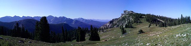
Geography
The area encompasses a stretch of the Front RangeFront Range
The Front Range is a mountain range of the Southern Rocky Mountains of North America located in the north-central portion of the U.S. State of Colorado and southeastern portion of the U.S. State of Wyoming. It is the first mountain range encountered moving west along the 40th parallel north across...
. It includes 7 peaks over 13,000 feet in elevation. The highest point is North Arapaho Peak at 13,502 feet. The peaks are all within 100 feet of elevation of each other. A portion of the area, encompassing the headwaters of North Boulder Creek, is closed to the public as it is the City of Boulder
Boulder, Colorado
Boulder is the county seat and most populous city of Boulder County and the 11th most populous city in the U.S. state of Colorado. Boulder is located at the base of the foothills of the Rocky Mountains at an elevation of...
watershed.
Peak names
Many of the peaks inside the wilderness area are named after western Native American tribesClassification of indigenous peoples of the Americas
Classification of indigenous peoples of the Americas is based upon cultural regions, geography, and linguistics. Anthropologists have named various cultural regions, with fluid boundaries, that are generally agreed upon with some variation...
. The naming scheme was the idea of botany
Botany
Botany, plant science, or plant biology is a branch of biology that involves the scientific study of plant life. Traditionally, botany also included the study of fungi, algae and viruses...
teacher Ellsworth Bethel. By 1914, few of the peaks between Longs Peak and the Arapaho Peaks had names. In the spring of that year Bethel, inspired by the established name of the Arapaho Peaks, settled on 11 tribal names for various summits along the Divide. The United States Board on Geographic Names
United States Board on Geographic Names
The United States Board on Geographic Names is a United States federal body whose purpose is to establish and maintain uniform usage of geographic names throughout the U.S. government.-Overview:...
kept 6 of his names: Apache Peak, Arikaree Peak, Kiowa Peak, Navajo Peak, Ogalalla Peak and Pawnee Peak. He later added Paiute Peak, as his use of the Ute band was denied due to too many other Colorado features sharing that name. Other names, including Shoshoni Peak, Hiamovi Mountain, Satanta Peak and Watanga Mountain were added later.
History
The Indian Peaks were visited by Native AmericansNative Americans in the United States
Native Americans in the United States are the indigenous peoples in North America within the boundaries of the present-day continental United States, parts of Alaska, and the island state of Hawaii. They are composed of numerous, distinct tribes, states, and ethnic groups, many of which survive as...
for several thousand years. The Arapaho
Arapaho
The Arapaho are a tribe of Native Americans historically living on the eastern plains of Colorado and Wyoming. They were close allies of the Cheyenne tribe and loosely aligned with the Sioux. Arapaho is an Algonquian language closely related to Gros Ventre, whose people are seen as an early...
tribe lived and hunted in the area during the summer months, though little evidence remains of their activities.
Mining took place in the 1870s near the Arapaho Peaks. Later, a road was built to Arapaho Pass but never completed. The mining turned up little more than low-grade ore, and the mines were eventually abandoned. Remnants of mining activity is still found along the Arapaho Pass trail.
A plane crash from the 1940s exists on Navajo Peak, not very far from the summit.
The area of the Indian Peaks were included in Eno Mills' original proposed boundaries for Rocky Mountain National Park. They were removed from the proposal after compromising with local and mining interests. Park superintendents tried to annex the Indian Peaks over the years, but the area would not receive protected status until 1978 when Congress designated the Indian Peaks Wilderness Area.
Activities
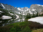
Most visitors hikeHiking
Hiking is an outdoor activity which consists of walking in natural environments, often in mountainous or other scenic terrain. People often hike on hiking trails. It is such a popular activity that there are numerous hiking organizations worldwide. The health benefits of different types of hiking...
along the many trails, visiting high passes, lakes and waterfalls en route. The area also contains many notable mountaineering
Mountaineering
Mountaineering or mountain climbing is the sport, hobby or profession of hiking, skiing, and climbing mountains. While mountaineering began as attempts to reach the highest point of unclimbed mountains it has branched into specialisations that address different aspects of the mountain and consists...
routes. The busiest area is Brainard Lake, which hosts several trailheads and a campground. Fishing
Fishing
Fishing is the activity of trying to catch wild fish. Fish are normally caught in the wild. Techniques for catching fish include hand gathering, spearing, netting, angling and trapping....
is also found in many of the lakes and streams within the wilderness. In the winter, snowshoeing and cross country skiing are popular.