
Boulder, Montana
Encyclopedia
Boulder is a town in and the county seat
of Jefferson County
, Montana
, United States
. It is on the north bank of the Boulder River between Butte and Helena, slightly east of the Continental Divide, at the intersection of Interstate 15
and Montana Highway 69
. The population was 1,300 at the 2000 census. It is part of the Helena
Micropolitan Statistical Area
.
Established as a 19th-century stagecoach
station, Boulder grew into a regional trading center for farmers, ranchers, and miners and, by the end of that century, home to state schools for the deaf, blind and developmentally disabled. In the 21st century, it is the center of government in Jefferson County, and institutions based in the town offer services for disabled or troubled youths. Its library system serves about 10,000 people, and its high school district covers more than 1000 square miles (2,590 km²). Three buildings in Boulder are listed on the National Register of Historic Places
.
and Virginia City
. It later became a trading center for nearby agricultural areas and the Elkhorn, Comet, and Baltimore mining districts. The Great Northern Railway branch line from Helena to Butte reached Boulder in 1888. State schools for the deaf, blind, and developmentally disabled were established in the city in 1892. In 1897, the town's name was shortened to Boulder.
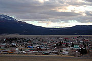 Boulder lies at an elevation of 4990 feet (1,521 m) above sea level along Interstate 15 at its intersection with Montana Highway 69
, about 35 miles (56 km) north of Butte
, and 27 miles (43 km) south of Helena
. The town is on the north bank of the Boulder River, a tributary of the Jefferson River
. According to the United States Census Bureau, the town has a total area of 1.1 square miles (2.8 km²), all land.
In the late Cretaceous
Period (roughly 81 to 74 million years ago), molten rock (magma
) rose to the Earth's surface in and near what later became Jefferson County and eventually formed an intrusive body of granitic
rock up to 10 miles (16 km) thick and 100 miles (161 km) in diameter. This body, known as the Boulder Batholith
, extends from Helena to Butte, and is the host rock for the many valuable ore
s mined in the region. As the granite cooled, it cracked, and hot solutions squirted into the cracks to form mineral veins bearing gold and other metals. Millions of years later, weathering allowed gold in the veins to wash down to the gravels in the Boulder River valley. The Boulder mining district was essentially limited to placer mining
of those gravels, because the source lode
s were in other mining districts in the mountains.
The Boulder area is underlain by the quartz monzonite
of the Boulder Batholith. The batholith is overlain by dacite
from the Tertiary
Period (roughly 65 million to 1.8 million years ago) and andesite
from the late Cretaceous. The andesite and monzonite are cut by dikes
of dacite and rhyolite
.
of 2000, there were 1,300 people, 508 households, and 316 families residing in the town. The population density
was 1,142.7 people per square mile (440.3/km²). There were 568 housing units at an average density of 499.3 per square mile (192.4/km²). The racial makeup of the town was 94.23% White, 0.23% African American, 2.31% Native American, 0.69% Asian, 0.08% Pacific Islander, 0.31% from other races
, and 2.15% from two or more races. Hispanic or Latino of any race were 1.15% of the population.
There were 508 households out of which 32.7% had children under the age of 18 living with them, 48.6% were married couples
living together, 10.4% had a female householder with no husband present, and 37.6% were non-families. 34.8% of all households were made up of individuals and 12.8% had someone living alone who was 65 years of age or older. The average household size was 2.34 and the average family size was 3.04.
In the town the population was spread out with 25.7% under the age of 18, 7.3% from 18 to 24, 30.8% from 25 to 44, 25.7% from 45 to 64, and 10.5% who were 65 years of age or older. The median age was 38 years. For every 100 females there were 103.1 males. For every 100 females age 18 and over, there were 102.5 males.
The median income for a household in the town was $29,276, and the median income for a family was $37,411. Males had a median income of $26,985 versus $22,500 for females. The per capita income
for the town was $14,657. About 10.7% of families and 15.6% of the population were below the poverty line, including 19.7% of those under age 18 and 13.3% of those age 65 or over.
Boulder and vicinity are home to commercial "health mines" for which it is claimed by testimonial that exposure to radon
gas mitigates auto-immune diseases such as arthritis
. Though contributing to the economy of the area by attracting tourists, the practice is controversial because of the "well-documented ill effects of high-dose radiation on the body."
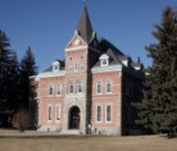
Boulder has three buildings on the National Register of Historic Places. The Jefferson County Courthouse, on Centennial Avenue, was added in 1980. The Montana Deaf and Dumb Asylum, also known as the Old Administration Building, off Montana Highway 69 (formerly Montana Secondary Highway 281) near Boulder, was added in 1985. The Boulder Hot Springs Hotel, southeast of Boulder on Montana Highway 69, was added in 1979.
Two weekly newspapers, The Boulder Monitor and The Jefferson County Courier are published in Boulder. A low-power radio station, KEME, 106.3 FM, owned by Jefferson County Disaster and Emergency Services, broadcasts from Boulder. A licensed FM radio translator, K296AN, owned by the Boulder TV Association, also broadcasts from Boulder.
County seat
A county seat is an administrative center, or seat of government, for a county or civil parish. The term is primarily used in the United States....
of Jefferson County
Jefferson County, Montana
-National protected areas:*Deerlodge National Forest *Helena National Forest -Demographics:As of the census of 2000, there were 10,049 people, 3,747 households, and 2,847 families residing in the county. The population density was 6 people per square mile . There were 4,199 housing units at an...
, Montana
Montana
Montana is a state in the Western United States. The western third of Montana contains numerous mountain ranges. Smaller, "island ranges" are found in the central third of the state, for a total of 77 named ranges of the Rocky Mountains. This geographical fact is reflected in the state's name,...
, United States
United States
The United States of America is a federal constitutional republic comprising fifty states and a federal district...
. It is on the north bank of the Boulder River between Butte and Helena, slightly east of the Continental Divide, at the intersection of Interstate 15
Interstate 15
Interstate 15 is the fourth-longest north–south Interstate Highway in the United States, traveling through the states of California, Nevada, Arizona, Utah, Idaho, and Montana from San Diego to the Canadian border...
and Montana Highway 69
Montana Highway 69
Highway 69 in the U.S. State of Montana is a route running northerly from an intersection with Montana Highway 55 in the community of Whitehall. The highway extends approximately to an intersection with Interstate 15 at the northern edge of the town of Boulder...
. The population was 1,300 at the 2000 census. It is part of the Helena
Helena, Montana
Helena is the capital city of the U.S. state of Montana and the county seat of Lewis and Clark County. The 2010 census put the population at 28,180. The local daily newspaper is the Independent Record. The Helena Brewers minor league baseball and Helena Bighorns minor league hockey team call the...
Micropolitan Statistical Area
Helena micropolitan area
The Helena Micropolitan Statistical Area, as defined by the United States Census Bureau, is an area consisting of two counties in western Montana, anchored by the city of Helena....
.
Established as a 19th-century stagecoach
Stagecoach
A stagecoach is a type of covered wagon for passengers and goods, strongly sprung and drawn by four horses, usually four-in-hand. Widely used before the introduction of railway transport, it made regular trips between stages or stations, which were places of rest provided for stagecoach travelers...
station, Boulder grew into a regional trading center for farmers, ranchers, and miners and, by the end of that century, home to state schools for the deaf, blind and developmentally disabled. In the 21st century, it is the center of government in Jefferson County, and institutions based in the town offer services for disabled or troubled youths. Its library system serves about 10,000 people, and its high school district covers more than 1000 square miles (2,590 km²). Three buildings in Boulder are listed on the National Register of Historic Places
National Register of Historic Places
The National Register of Historic Places is the United States government's official list of districts, sites, buildings, structures, and objects deemed worthy of preservation...
.
History
Named for the many large boulders in the vicinity, the town of Boulder Valley was established in the early 1860s as a stagecoach station on the route between Fort BentonFort Benton, Montana
Fort Benton is a city in and the county seat of Chouteau County, Montana, United States. A portion of the city was designated as a National Historic Landmark District in 1961. Established a full generation beforethe U.S...
and Virginia City
Virginia City, Montana
Virginia City is a town in and the county seat of Madison County, Montana, United States. In 1961, the town and the surrounding area was designated a National Historic Landmark District, the Virginia City Historic District...
. It later became a trading center for nearby agricultural areas and the Elkhorn, Comet, and Baltimore mining districts. The Great Northern Railway branch line from Helena to Butte reached Boulder in 1888. State schools for the deaf, blind, and developmentally disabled were established in the city in 1892. In 1897, the town's name was shortened to Boulder.
Geography and geology
Montana Highway 69
Highway 69 in the U.S. State of Montana is a route running northerly from an intersection with Montana Highway 55 in the community of Whitehall. The highway extends approximately to an intersection with Interstate 15 at the northern edge of the town of Boulder...
, about 35 miles (56 km) north of Butte
Butte, Montana
Butte is a city in Montana and the county seat of Silver Bow County, United States. In 1977, the city and county governments consolidated to form the sole entity of Butte-Silver Bow. As of the 2010 census, Butte's population was 34,200...
, and 27 miles (43 km) south of Helena
Helena, Montana
Helena is the capital city of the U.S. state of Montana and the county seat of Lewis and Clark County. The 2010 census put the population at 28,180. The local daily newspaper is the Independent Record. The Helena Brewers minor league baseball and Helena Bighorns minor league hockey team call the...
. The town is on the north bank of the Boulder River, a tributary of the Jefferson River
Jefferson River
The Jefferson River is a tributary of the Missouri River, approximately long, in the U.S. state of Montana. The Jefferson River and the Madison River form the official beginning of the Missouri at Missouri Headwaters State Park near Three Forks...
. According to the United States Census Bureau, the town has a total area of 1.1 square miles (2.8 km²), all land.
In the late Cretaceous
Cretaceous
The Cretaceous , derived from the Latin "creta" , usually abbreviated K for its German translation Kreide , is a geologic period and system from circa to million years ago. In the geologic timescale, the Cretaceous follows the Jurassic period and is followed by the Paleogene period of the...
Period (roughly 81 to 74 million years ago), molten rock (magma
Magma
Magma is a mixture of molten rock, volatiles and solids that is found beneath the surface of the Earth, and is expected to exist on other terrestrial planets. Besides molten rock, magma may also contain suspended crystals and dissolved gas and sometimes also gas bubbles. Magma often collects in...
) rose to the Earth's surface in and near what later became Jefferson County and eventually formed an intrusive body of granitic
Granite
Granite is a common and widely occurring type of intrusive, felsic, igneous rock. Granite usually has a medium- to coarse-grained texture. Occasionally some individual crystals are larger than the groundmass, in which case the texture is known as porphyritic. A granitic rock with a porphyritic...
rock up to 10 miles (16 km) thick and 100 miles (161 km) in diameter. This body, known as the Boulder Batholith
Boulder Batholith
The Boulder Batholith is a small batholith in southwest Montana, exposed at the surface as granite and serving as the host rock for rich mineralized deposits at Butte, Montana and other locations....
, extends from Helena to Butte, and is the host rock for the many valuable ore
Ore
An ore is a type of rock that contains minerals with important elements including metals. The ores are extracted through mining; these are then refined to extract the valuable element....
s mined in the region. As the granite cooled, it cracked, and hot solutions squirted into the cracks to form mineral veins bearing gold and other metals. Millions of years later, weathering allowed gold in the veins to wash down to the gravels in the Boulder River valley. The Boulder mining district was essentially limited to placer mining
Placer mining
Placer mining is the mining of alluvial deposits for minerals. This may be done by open-pit or by various surface excavating equipment or tunneling equipment....
of those gravels, because the source lode
Lode
In geology, a lode is a deposit of metalliferous ore that fills or is embedded in a fissure in a rock formation or a vein of ore that is deposited or embedded between layers of rock....
s were in other mining districts in the mountains.
The Boulder area is underlain by the quartz monzonite
Quartz monzonite
Quartz monzonite is an intrusive igneous rock that has an approximately equal proportion of orthoclase and plagioclase feldspars. The plagioclase is typically intermediate to sodic in composition, andesine to oligoclase. Quartz is present in significant amounts. Biotite and/or hornblende...
of the Boulder Batholith. The batholith is overlain by dacite
Dacite
Dacite is an igneous, volcanic rock. It has an aphanitic to porphyritic texture and is intermediate in composition between andesite and rhyolite. The relative proportions of feldspars and quartz in dacite, and in many other volcanic rocks, are illustrated in the QAPF diagram...
from the Tertiary
Tertiary
The Tertiary is a deprecated term for a geologic period 65 million to 2.6 million years ago. The Tertiary covered the time span between the superseded Secondary period and the Quaternary...
Period (roughly 65 million to 1.8 million years ago) and andesite
Andesite
Andesite is an extrusive igneous, volcanic rock, of intermediate composition, with aphanitic to porphyritic texture. In a general sense, it is the intermediate type between basalt and dacite. The mineral assemblage is typically dominated by plagioclase plus pyroxene and/or hornblende. Magnetite,...
from the late Cretaceous. The andesite and monzonite are cut by dikes
Dike (geology)
A dike or dyke in geology is a type of sheet intrusion referring to any geologic body that cuts discordantly across* planar wall rock structures, such as bedding or foliation...
of dacite and rhyolite
Rhyolite
This page is about a volcanic rock. For the ghost town see Rhyolite, Nevada, and for the satellite system, see Rhyolite/Aquacade.Rhyolite is an igneous, volcanic rock, of felsic composition . It may have any texture from glassy to aphanitic to porphyritic...
.
Demographics
As of the censusCensus
A census is the procedure of systematically acquiring and recording information about the members of a given population. It is a regularly occurring and official count of a particular population. The term is used mostly in connection with national population and housing censuses; other common...
of 2000, there were 1,300 people, 508 households, and 316 families residing in the town. The population density
Population density
Population density is a measurement of population per unit area or unit volume. It is frequently applied to living organisms, and particularly to humans...
was 1,142.7 people per square mile (440.3/km²). There were 568 housing units at an average density of 499.3 per square mile (192.4/km²). The racial makeup of the town was 94.23% White, 0.23% African American, 2.31% Native American, 0.69% Asian, 0.08% Pacific Islander, 0.31% from other races
Race (United States Census)
Race and ethnicity in the United States Census, as defined by the Federal Office of Management and Budget and the United States Census Bureau, are self-identification data items in which residents choose the race or races with which they most closely identify, and indicate whether or not they are...
, and 2.15% from two or more races. Hispanic or Latino of any race were 1.15% of the population.
There were 508 households out of which 32.7% had children under the age of 18 living with them, 48.6% were married couples
Marriage
Marriage is a social union or legal contract between people that creates kinship. It is an institution in which interpersonal relationships, usually intimate and sexual, are acknowledged in a variety of ways, depending on the culture or subculture in which it is found...
living together, 10.4% had a female householder with no husband present, and 37.6% were non-families. 34.8% of all households were made up of individuals and 12.8% had someone living alone who was 65 years of age or older. The average household size was 2.34 and the average family size was 3.04.
In the town the population was spread out with 25.7% under the age of 18, 7.3% from 18 to 24, 30.8% from 25 to 44, 25.7% from 45 to 64, and 10.5% who were 65 years of age or older. The median age was 38 years. For every 100 females there were 103.1 males. For every 100 females age 18 and over, there were 102.5 males.
The median income for a household in the town was $29,276, and the median income for a family was $37,411. Males had a median income of $26,985 versus $22,500 for females. The per capita income
Per capita income
Per capita income or income per person is a measure of mean income within an economic aggregate, such as a country or city. It is calculated by taking a measure of all sources of income in the aggregate and dividing it by the total population...
for the town was $14,657. About 10.7% of families and 15.6% of the population were below the poverty line, including 19.7% of those under age 18 and 13.3% of those age 65 or over.
Economy
About 300 people are employed in Boulder at the Montana Developmental Center, a state institution for people with developmental disabilities. Another 100 or so people work for Alternative Youth Adventures, which provides services for troubled youth. In addition, Riverside Corrections, a state-run detention center for juvenile females, employs about 30 people.Boulder and vicinity are home to commercial "health mines" for which it is claimed by testimonial that exposure to radon
Radon
Radon is a chemical element with symbol Rn and atomic number 86. It is a radioactive, colorless, odorless, tasteless noble gas, occurring naturally as the decay product of uranium or thorium. Its most stable isotope, 222Rn, has a half-life of 3.8 days...
gas mitigates auto-immune diseases such as arthritis
Arthritis
Arthritis is a form of joint disorder that involves inflammation of one or more joints....
. Though contributing to the economy of the area by attracting tourists, the practice is controversial because of the "well-documented ill effects of high-dose radiation on the body."
Arts and culture
Boulder Community Library is the center of a library system serving about 10,000 people in Jefferson County, Montana. In 2005, it had about 39,000 books and serial volumes in its collection, 85 subscriptions, 3,200 videos, 1,500 audio materials, and 21 Internet terminals.Boulder has three buildings on the National Register of Historic Places. The Jefferson County Courthouse, on Centennial Avenue, was added in 1980. The Montana Deaf and Dumb Asylum, also known as the Old Administration Building, off Montana Highway 69 (formerly Montana Secondary Highway 281) near Boulder, was added in 1985. The Boulder Hot Springs Hotel, southeast of Boulder on Montana Highway 69, was added in 1979.
Two weekly newspapers, The Boulder Monitor and The Jefferson County Courier are published in Boulder. A low-power radio station, KEME, 106.3 FM, owned by Jefferson County Disaster and Emergency Services, broadcasts from Boulder. A licensed FM radio translator, K296AN, owned by the Boulder TV Association, also broadcasts from Boulder.