
Big Timber Creek
Encyclopedia
Big Timber Creek is a 5.6 miles (9 km) stream in southwestern New Jersey
, United States, and is also known by the name 'Tetamekanchz Kyl' by the Lenape
tribes. It drains a watershed of 63 square miles (163.2 km²). A tributary of the Delaware River
, it enters the Delaware between the boroughs of Brooklawn
and Westville
, just south Gloucester City
and across from Philadelphia, Pennsylvania
. The main stream and South Branch form about half of the border between Camden
and Gloucester
counties.
Pre-Columbian Big Timber Creek was home to numerous villages of the Lenni Lenape
. In colonial times, the creek was a commercial waterway, and it powered a multitude of mills up through the 1950s. In the second half of the 20th century it suffered the ill effects of the rapid post–World War II development that plagued many of America's waterways. As of 2007, it had recovered somewhat, thanks to pollution controls and improvements in sewage treatment.
tribe, with the North Branch named Tetamekanchz, the Chews Landing section named Arwames, Beaver Branch called Tekoke, and Little Timber Creek named Sassackon. The earliest recorded use of the current name is by an early Dutch explorer, David P. DeVries
, who refers to a Timmer Kill, "Timber Creek" in Dutch, in his memoirs of his journey of 1630–1633, after the construction of Fort Nassau
at its mouth. This name became anglicized when the Quakers
arrived. In 1697, the West Jersey
Proprietors
, in creating the town of Gloucester
, decreed that the name be the "Gloucester River", and although that name did appear in documents for several years, it faded away. A much smaller creek lying to the north, Little Timber Creek, finds the Delaware at the same place as its larger namesake. To differentiate between the two, the latter came to be known as "Great Timber Creek", which soon became "Big Timber Creek". Even so, at the end of the 20th century it was still usually referred to in speech as simply "Timber Creek".
s, not as the crow flies.)
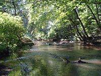
Big Timber Creek flows roughly to the northwest. Two streams, the North Branch and the South Branch, join 5.6 miles (9 km) above its mouth to form the main stream. The South Branch is considered the source stream. Both branches are dammed at several points to form impoundments—no natural lakes occur along either branch.
 Two streams join to form the South Branch of Big Timber Creek, the Big Lebanon Branch and the Little Lebanon Branch.
Big Lebanon Branch is considered the source stream, as it is the longer. Indeed, it appears on some maps as "Big Timber Creek". It rises near Cross Keys
in Gloucester County (under a housing development) at an elevation of about 160 feet (48.8 m) and flows northwesterly 2.4 miles (3.9 km), fed by several streams from the east along the way, to its confluence with the Little Lebanon Branch just above Nash's Lake in Turnersville. About 1 miles (1.6 km) north of its source, at the head of Jones Lake, Big Lebanon receives Long Hollow Branch. Jones Lake is formed by a dam about a 0.25 mile (0.402335 km) on and lies at an elevation of about 110 feet (33.5 m). Just beyond the dam, Chestnut Branch comes in, and Big Lebanon veers northwest to run along the south side of the Atlantic City Expressway
. 0.5 mile (0.80467 km) beyond Chestnut Branch it receives Slab Bridge Branch, and after another half mile, Jeremys Field Branch about 0.3 mile (0.482802 km) above its confluence with Little Lebanon.
Little Lebanon Branch lies within Gloucester County. It begins at Baum Pond (in 2007, dry) at an elevation of about 135 feet (41.1 m) near the intersection of Stagecoach Road and the Black Horse Pike. It flows roughly north for 1.9 miles (3.1 km) to meet the Big Lebanon and with it form the South Branch of Big Timber Creek. Little Lebanon has no significant tributaries.
The South Branch proper begins just above Nash's Lake in Washington Township
and runs northward for 9.1 miles (14.6 km) to the point where it joins the North Branch. It forms several impoundments and receives a number of smaller streams over its course. Just below its head, the South Branch passes under the Atlantic City Expressway to be dammed about a third of a mile down to form Nash's Lake at an elevation of 79 feet (24.1 m). After weaving once under the highway for about two-thirds of a mile (1 km), it receives Stone Bridge Branch and Toms Branch from the east in quick succession and, passing under the highway (now Route 42) to the west, it flows north for a mile to Grenloch Lake in Turnersville
. Grenloch Lake lies at an elevation of 44 feet (13.4 m) and extends for a half mile (0.8 km) above its dam. The lake receives Holly Run from the northeast before passing under the Black Horse Pike, whereupon Bells Lake Branch enters from the south. Below Grenloch Lake's dam, the South Branch wanders northwest for a mile (1.6 km) to Blackwood Lake in Blackwood
, having picked up Gardner's Run from the southwest about halfway along. At an elevation of 18 feet (5.5 m), Blackwood Lake snakes almost a mile along the foot of an escarpment
to its west. Farrows Run enters from the east about at the midpoint. About a quarter mile below the dam, two streams join the South Branch, Bull Run from the west and Minqus Run from the east. About a mile farther on, the stream grows sluggish and tidal. Another mile, and Pines Run enters from the east just after the South Branch passes under Route 42 south-to-north. Its final mile lies among wetlands and mudflats.
 The North Branch of Big Timber Creek rises near Albion at an elevation of about 135 feet (41.1 m), about 2.5 miles (4 km) from Pine Hill (the hill, not the town
, which is nearer), the highest point in southern New Jersey at about 200 feet (61 m). The North Branch flows northwestward 10.1 miles (16.3 km) through several impoundments to Chews Landing and thence to its confluence with the South Branch.
From its origin, the North Branch skirts the northern edge of the world-renowned Pine Valley Golf Club
and enters Lekau Lake a mile down. A teardrop-shaped impoundment about third of a mile (0.5 km) long, Lekau Lake lies at an elevation of 76 feet (23.2 m) in a hollow of the hills. Leaving the lake, the North Branch twines its way a mile northwest, down to 51 feet (15.5 m), and enters Clementon Lake
in Clementon
, long a recreational mecca for the region. A quarter mile (0.4 km) below the lake Trout Run enters from the east, and a half mile farther on, Gravelly Run. The North Branch then runs more to the west for a mile to Laurel Lake, a sinuous half-mile-long (0.8 km) impoundment which lies at an elevation of about 30 feet (9.1 m). The North Branch continues its westerly course for three-quarters of a mile (1.2 km) below Laurel Lake, turning northward where Mason Run enters from the south. It turns to the westward again after another three-quarters of a mile, immediately after which it receives Signey Run from the north. The North Branch then tends northwestward, widening and slowing a mile along, and, turning west upon receiving Otter Branch from the north a half mile farther down, enters an impoundment at Chews Landing
. This impoundment is a consequence of the constriction at the point about a third of a mile (0.5 km) down where the North Branch passes under the Black Horse Pike. The North Branch is now tidal and runs westward through wetlands another mile to its confluence with the South Branch.
 The main stream of Big Timber Creek begins in Glendora
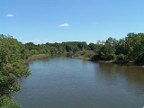
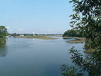
, just upstream from Clement's Bridge, at the confluence of the North and South branches. It meanders northwest for 5.6 miles (9 km) to empty into the Delaware River between Westville and Brooklawn. Over much of its length it is hemmed in by roads, old dumps, and fill. It opens out into wetlands here and there. The main stream is tidal throughout.
The first mile (1.6 km) of the main stream is essentially a ditch between a housing development and a trash dump. Three-quarters of a mile (1.2 km) downstream from its head, the main stream receives from the north the waters of Hirsch Lake in Runnemede
, a smallish impoundment fed by an unnamed stream. A quarter mile (0.4 km) on, the left bank recedes into wetlands, and Almonesson Creek enters on the left another quarter mile down. A further half mile (0.8 km) sees Beaver Brook enter on the right, and the stream narrows again as it passes under Route 42 and the New Jersey Turnpike
. It remains confined for the next mile and a half (2.4 km), receiving Ladd's Branch on the left at one mile and flowing another half mile to pass under Route 295
, shortly after which it opens out into three-quarters of a mile of wetlands crossed by navigable channels. The stream forms three channels here, the main one hugging the left bank by Westville. The rightmost channel flows through the borough of Belmawr and has several small marinas and private docks located along its banks. The creek then flows another three-quarters of a mile under State Route 47, through Michael K. Galbraith Park in Westville, finally opening up into a shallow bay and flowing into the Delaware River.
Physiographic Province, specifically that portion known as the Inner Coastal Plain. The coastal plain is a wedge-shaped mass of sediment
s, mostly unconsolidated, lying upon Precambrian
basement rock
. It extends from the fall line
out onto the continental shelf
, thickening as it goes at the rate of 80 to 100 feet per mile (15–19 m/km).
New Jersey's inner coastal plain is defined by a cuesta
that runs through the coastal plain roughly northeast to southwest across the middle and southern parts of the state. This cuesta marks the transition between the underlying Cretaceous
sediments toward the Piedmont
and the more recent Miocene
sediments seaward and is itself Cretaceous in origin. In its southern reaches, where Big Timber Creek lies, it runs roughly parallel to the Delaware River at a distance of about 20 miles (32 km) and delineates the left edge of the Delaware River watershed
in southern New Jersey.
The surficial geology
of the New Jersey inner coastal plain is among the most complex in the world. At least eight of the 14 or 15 sedimentary strata, or formations
, laid down since the Cretaceous period appear at the surface in the Big Timber Creek basin
. Each formation is itself made up of many layers, some the result of irregular interglacial stream deposition. The situation is further complicated by the appearance of fragments of older formations at a shallower level than more recent ones, owing to cycles of deposition and erosion
; in fact, the so-called Bridgeton formation, the oldest, containing iron-indurated sand
, forms the summits of the few prominences on the landscape. Generally speaking, the surface of the area is weathered Cretaceous coastal plain consisting of quartz
sand, with patches where gravel
or clay
are found. Glauconite
occurs in varying concentrations in the younger formations, and some bog iron
is seen. There is no rock
, though some iron-bearing sand has become concreted and rock-like.
marine inundations which deposited fresh layers of sediment. Big Timber Creek's watershed
encompasses 63 square miles (163 km2), including Little Timber Creek, a small creek that shares its mouth. The sides of the basin are defined by the patchy remains of relatively erosion-resistant formations. Nowhere in its basin does the relief
exceed 200 feet (61 m), and much lies below 50 feet (15 m). What relief there is entirely due to erosion, mostly by Big Timber Creek and its tributaries.
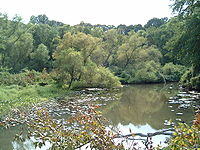
The terrain consists mainly of a jumble of the low, flattened ridges typical of mature sandy basins. The scattered prominences of 100 feet (30 m) or more, some quite steep, owe their existence to caps of iron-rich sand. A cuesta forms escarpments beyond the headwaters of the Creek and along some of its southerly tributaries. There is a small, marshy floodplain
in the lower reaches.
New Jersey
New Jersey is a state in the Northeastern and Middle Atlantic regions of the United States. , its population was 8,791,894. It is bordered on the north and east by the state of New York, on the southeast and south by the Atlantic Ocean, on the west by Pennsylvania and on the southwest by Delaware...
, United States, and is also known by the name 'Tetamekanchz Kyl' by the Lenape
Lenape
The Lenape are an Algonquian group of Native Americans of the Northeastern Woodlands. They are also called Delaware Indians. As a result of the American Revolutionary War and later Indian removals from the eastern United States, today the main groups live in Canada, where they are enrolled in the...
tribes. It drains a watershed of 63 square miles (163.2 km²). A tributary of the Delaware River
Delaware River
The Delaware River is a major river on the Atlantic coast of the United States.A Dutch expedition led by Henry Hudson in 1609 first mapped the river. The river was christened the South River in the New Netherland colony that followed, in contrast to the North River, as the Hudson River was then...
, it enters the Delaware between the boroughs of Brooklawn
Brooklawn, New Jersey
Brooklawn is a Borough in Camden County, New Jersey, United States. As of the 2010 United States Census, the borough population was 1,955.Brooklawn was incorporated as a borough on March 11, 1924, from portions of the now-defunct Centre Township, based on the results of a referendum held on April...
and Westville
Westville, New Jersey
Westville is a Borough in Gloucester County, New Jersey, United States. As of the 2000 United States Census, the borough population was 4,501. The Borough of Westville is known as "The Gateway to South Jersey."...
, just south Gloucester City
Gloucester City, New Jersey
Gloucester City is a city in Camden County, New Jersey, United States. As of the United States 2010 Census, the city population was 11,456.-Geography:Gloucester City is located at ....
and across from Philadelphia, Pennsylvania
Pennsylvania
The Commonwealth of Pennsylvania is a U.S. state that is located in the Northeastern and Mid-Atlantic regions of the United States. The state borders Delaware and Maryland to the south, West Virginia to the southwest, Ohio to the west, New York and Ontario, Canada, to the north, and New Jersey to...
. The main stream and South Branch form about half of the border between Camden
Camden County, New Jersey
-Demographics:As of the 2010 Census the population of Camden County was 60.28% Non-Hispanic white, 18.45% Non-Hispanic black, 1.12% Hispanic blacks, 0.17% Non-Hispanic Native American, 0.15% Hispanic Native Americans, 5.07% Non-Hispanic Asian, and 0.14% non-Hispanics reporting some other race...
and Gloucester
Gloucester County, New Jersey
Gloucester County is a county located in the U.S. state of New Jersey. As of the 2010 Census, the population was 288,288. Its county seat is Woodbury....
counties.
Pre-Columbian Big Timber Creek was home to numerous villages of the Lenni Lenape
Lenape
The Lenape are an Algonquian group of Native Americans of the Northeastern Woodlands. They are also called Delaware Indians. As a result of the American Revolutionary War and later Indian removals from the eastern United States, today the main groups live in Canada, where they are enrolled in the...
. In colonial times, the creek was a commercial waterway, and it powered a multitude of mills up through the 1950s. In the second half of the 20th century it suffered the ill effects of the rapid post–World War II development that plagued many of America's waterways. As of 2007, it had recovered somewhat, thanks to pollution controls and improvements in sewage treatment.
The name
The creek was named Tetamekanchz by the local LenapeLenape
The Lenape are an Algonquian group of Native Americans of the Northeastern Woodlands. They are also called Delaware Indians. As a result of the American Revolutionary War and later Indian removals from the eastern United States, today the main groups live in Canada, where they are enrolled in the...
tribe, with the North Branch named Tetamekanchz, the Chews Landing section named Arwames, Beaver Branch called Tekoke, and Little Timber Creek named Sassackon. The earliest recorded use of the current name is by an early Dutch explorer, David P. DeVries
David Pietersen de Vries
Captain David Pieterszoon de Vries was a Dutch navigator from Hoorn, Holland.In 1617 de Vries went on a whaling voyage to Jan Mayen. In 1620 he sailed to Newfoundland and sold the dried fish in Italy. In Toulon he joined Charles, Duke of Guise. In 1624 he went to Canada again, still in French...
, who refers to a Timmer Kill, "Timber Creek" in Dutch, in his memoirs of his journey of 1630–1633, after the construction of Fort Nassau
Fort Nassau (South River)
Fort Nassau was a factorij in the colonial province of New Netherland from 1623-1651.The name Fort Nassau was used by the Dutch in the 17th century for several fortifications, mostly trading stations, named for the House of Orange-Nassau....
at its mouth. This name became anglicized when the Quakers
Religious Society of Friends
The Religious Society of Friends, or Friends Church, is a Christian movement which stresses the doctrine of the priesthood of all believers. Members are known as Friends, or popularly as Quakers. It is made of independent organisations, which have split from one another due to doctrinal differences...
arrived. In 1697, the West Jersey
West Jersey
West Jersey and East Jersey were two distinct parts of the Province of New Jersey. The political division existed for 28 years, between 1674 and 1702...
Proprietors
Lords Proprietor
Lords Proprietor was the name for the chief or highest owners or proprietors of certain English proprietary colonies in America, such as Carolina, New Jersey and Barbados....
, in creating the town of Gloucester
Gloucester City, New Jersey
Gloucester City is a city in Camden County, New Jersey, United States. As of the United States 2010 Census, the city population was 11,456.-Geography:Gloucester City is located at ....
, decreed that the name be the "Gloucester River", and although that name did appear in documents for several years, it faded away. A much smaller creek lying to the north, Little Timber Creek, finds the Delaware at the same place as its larger namesake. To differentiate between the two, the latter came to be known as "Great Timber Creek", which soon became "Big Timber Creek". Even so, at the end of the 20th century it was still usually referred to in speech as simply "Timber Creek".
Course
(Note: All course mileage figures are approximate river mileRiver mile
In the United States, a River mile is a measure of distance in miles along a river from its mouth. River mile numbers begin at zero and increase further upstream. The corresponding metric unit using kilometers is the River kilometer...
s, not as the crow flies.)
Big Timber Creek flows roughly to the northwest. Two streams, the North Branch and the South Branch, join 5.6 miles (9 km) above its mouth to form the main stream. The South Branch is considered the source stream. Both branches are dammed at several points to form impoundments—no natural lakes occur along either branch.
South Branch
Big Lebanon Branch is considered the source stream, as it is the longer. Indeed, it appears on some maps as "Big Timber Creek". It rises near Cross Keys
Cross Keys, New Jersey
Cross Keys is an unincorporated area, within Monroe Township, in Gloucester County, New Jersey, United States. The area is north-west of Williamstown and east of Glassboro, about 15 miles south-south-east of downtown Philadelphia.-Transportation:...
in Gloucester County (under a housing development) at an elevation of about 160 feet (48.8 m) and flows northwesterly 2.4 miles (3.9 km), fed by several streams from the east along the way, to its confluence with the Little Lebanon Branch just above Nash's Lake in Turnersville. About 1 miles (1.6 km) north of its source, at the head of Jones Lake, Big Lebanon receives Long Hollow Branch. Jones Lake is formed by a dam about a 0.25 mile (0.402335 km) on and lies at an elevation of about 110 feet (33.5 m). Just beyond the dam, Chestnut Branch comes in, and Big Lebanon veers northwest to run along the south side of the Atlantic City Expressway
Atlantic City Expressway
The Atlantic City Expressway is a , controlled-access toll road in New Jersey, managed and operated by the South Jersey Transportation Authority...
. 0.5 mile (0.80467 km) beyond Chestnut Branch it receives Slab Bridge Branch, and after another half mile, Jeremys Field Branch about 0.3 mile (0.482802 km) above its confluence with Little Lebanon.
Little Lebanon Branch lies within Gloucester County. It begins at Baum Pond (in 2007, dry) at an elevation of about 135 feet (41.1 m) near the intersection of Stagecoach Road and the Black Horse Pike. It flows roughly north for 1.9 miles (3.1 km) to meet the Big Lebanon and with it form the South Branch of Big Timber Creek. Little Lebanon has no significant tributaries.
The South Branch proper begins just above Nash's Lake in Washington Township
Washington Township, Gloucester County, New Jersey
Washington Township is a township in Gloucester County, New Jersey, United States. In the 2010 United States Census, Washington Township's population was 48,559, having grown from 47,114 in the 2000 Census....
and runs northward for 9.1 miles (14.6 km) to the point where it joins the North Branch. It forms several impoundments and receives a number of smaller streams over its course. Just below its head, the South Branch passes under the Atlantic City Expressway to be dammed about a third of a mile down to form Nash's Lake at an elevation of 79 feet (24.1 m). After weaving once under the highway for about two-thirds of a mile (1 km), it receives Stone Bridge Branch and Toms Branch from the east in quick succession and, passing under the highway (now Route 42) to the west, it flows north for a mile to Grenloch Lake in Turnersville
Turnersville, New Jersey
Turnersville is a census-designated place and unincorporated area located within Washington Township, in Gloucester County, New Jersey. As of the United States 2000 Census, the CDP population was 3,867. It is named after the Turner family, one of the original families of Washington Township...
. Grenloch Lake lies at an elevation of 44 feet (13.4 m) and extends for a half mile (0.8 km) above its dam. The lake receives Holly Run from the northeast before passing under the Black Horse Pike, whereupon Bells Lake Branch enters from the south. Below Grenloch Lake's dam, the South Branch wanders northwest for a mile (1.6 km) to Blackwood Lake in Blackwood
Blackwood, New Jersey
Blackwood is a census-designated place located within Gloucester Township, in Camden County, New Jersey. As of the 2000 United States Census, the section population was 4,692...
, having picked up Gardner's Run from the southwest about halfway along. At an elevation of 18 feet (5.5 m), Blackwood Lake snakes almost a mile along the foot of an escarpment
Escarpment
An escarpment is a steep slope or long cliff that occurs from erosion or faulting and separates two relatively level areas of differing elevations.-Description and variants:...
to its west. Farrows Run enters from the east about at the midpoint. About a quarter mile below the dam, two streams join the South Branch, Bull Run from the west and Minqus Run from the east. About a mile farther on, the stream grows sluggish and tidal. Another mile, and Pines Run enters from the east just after the South Branch passes under Route 42 south-to-north. Its final mile lies among wetlands and mudflats.
North Branch
Pine Hill, New Jersey
Pine Hill is a Borough in Camden County, New Jersey, United States. As of the 2010 United States Census, the borough had a total population of 10,233....
, which is nearer), the highest point in southern New Jersey at about 200 feet (61 m). The North Branch flows northwestward 10.1 miles (16.3 km) through several impoundments to Chews Landing and thence to its confluence with the South Branch.
From its origin, the North Branch skirts the northern edge of the world-renowned Pine Valley Golf Club
Pine Valley Golf Club
Pine Valley Golf Club is a golf course in Pine Valley, Camden County, in southern New Jersey. It was ranked the number one course in Golf Magazines 100 Top Courses in the U.S. and the World in 2009.-History:...
and enters Lekau Lake a mile down. A teardrop-shaped impoundment about third of a mile (0.5 km) long, Lekau Lake lies at an elevation of 76 feet (23.2 m) in a hollow of the hills. Leaving the lake, the North Branch twines its way a mile northwest, down to 51 feet (15.5 m), and enters Clementon Lake
Clementon Amusement Park
Clementon Park and Splash World is a small amusement park located in Clementon, New Jersey in Camden County, New Jersey, United States right on Clementon Lake and close to the Pine Valley Golf Club. Also known as Clementon Lake Park, it is one of the world's oldest operating amusement parks...
in Clementon
Clementon, New Jersey
Clementon is a Borough in Camden County, New Jersey, United States. As of the 2010 United States Census, the borough population was 5,000.Around 1800, Jonathon Haines built a glass factory in what is now present day Clementon, situated on a large hill across the street from the modern day Clementon...
, long a recreational mecca for the region. A quarter mile (0.4 km) below the lake Trout Run enters from the east, and a half mile farther on, Gravelly Run. The North Branch then runs more to the west for a mile to Laurel Lake, a sinuous half-mile-long (0.8 km) impoundment which lies at an elevation of about 30 feet (9.1 m). The North Branch continues its westerly course for three-quarters of a mile (1.2 km) below Laurel Lake, turning northward where Mason Run enters from the south. It turns to the westward again after another three-quarters of a mile, immediately after which it receives Signey Run from the north. The North Branch then tends northwestward, widening and slowing a mile along, and, turning west upon receiving Otter Branch from the north a half mile farther down, enters an impoundment at Chews Landing
Chews Landing, New Jersey
Chews Landing is an unincorporated area within Gloucester Township, Camden County, New Jersey. Located near the Big Timber Creek, Chews Landing is named after Jeremiah Chew, a revolutionary officer....
. This impoundment is a consequence of the constriction at the point about a third of a mile (0.5 km) down where the North Branch passes under the Black Horse Pike. The North Branch is now tidal and runs westward through wetlands another mile to its confluence with the South Branch.
Main stream
Glendora, New Jersey
Glendora is a census-designated place and unincorporated area located within Gloucester Township, in Camden County, New Jersey. As of the 2000 United States Census, the CDP population was 4,907.-Geography:Glendora is located at ....
, just upstream from Clement's Bridge, at the confluence of the North and South branches. It meanders northwest for 5.6 miles (9 km) to empty into the Delaware River between Westville and Brooklawn. Over much of its length it is hemmed in by roads, old dumps, and fill. It opens out into wetlands here and there. The main stream is tidal throughout.
The first mile (1.6 km) of the main stream is essentially a ditch between a housing development and a trash dump. Three-quarters of a mile (1.2 km) downstream from its head, the main stream receives from the north the waters of Hirsch Lake in Runnemede
Runnemede, New Jersey
Runnemede is a borough in Camden County, New Jersey, United States. As of the 2000 United States Census, the borough population is 8,533.Runnemede was incorporated as a borough by an Act of the New Jersey Legislature on March 23, 1926, from portions of the now-defunct Centre Township, based on the...
, a smallish impoundment fed by an unnamed stream. A quarter mile (0.4 km) on, the left bank recedes into wetlands, and Almonesson Creek enters on the left another quarter mile down. A further half mile (0.8 km) sees Beaver Brook enter on the right, and the stream narrows again as it passes under Route 42 and the New Jersey Turnpike
New Jersey Turnpike
The New Jersey Turnpike is a toll road in New Jersey, maintained by the New Jersey Turnpike Authority. According to the International Bridge, Tunnel and Turnpike Association, the Turnpike is the nation's sixth-busiest toll road and is among one of the most heavily traveled highways in the United...
. It remains confined for the next mile and a half (2.4 km), receiving Ladd's Branch on the left at one mile and flowing another half mile to pass under Route 295
Interstate 295 (Delaware-New Jersey)
Interstate 295 in New Jersey and Delaware is an auxiliary Interstate Highway, designated as a bypass around Philadelphia, Pennsylvania. The route begins at a junction with Interstate 95 south of Wilmington, Delaware, and runs to another junction with I-95 north of Trenton, New Jersey...
, shortly after which it opens out into three-quarters of a mile of wetlands crossed by navigable channels. The stream forms three channels here, the main one hugging the left bank by Westville. The rightmost channel flows through the borough of Belmawr and has several small marinas and private docks located along its banks. The creek then flows another three-quarters of a mile under State Route 47, through Michael K. Galbraith Park in Westville, finally opening up into a shallow bay and flowing into the Delaware River.
Geology
Big Timber Creek lies wholly within in the Atlantic Coastal PlainAtlantic Coastal Plain
The Atlantic coastal plain has both low elevation and low relief, but it is also a relatively flat landform extending from the New York Bight southward to a Georgia/Florida section of the Eastern Continental Divide, which demarcates the plain from the ACF River Basin in the Gulf Coastal Plain to...
Physiographic Province, specifically that portion known as the Inner Coastal Plain. The coastal plain is a wedge-shaped mass of sediment
Sediment
Sediment is naturally occurring material that is broken down by processes of weathering and erosion, and is subsequently transported by the action of fluids such as wind, water, or ice, and/or by the force of gravity acting on the particle itself....
s, mostly unconsolidated, lying upon Precambrian
Precambrian
The Precambrian is the name which describes the large span of time in Earth's history before the current Phanerozoic Eon, and is a Supereon divided into several eons of the geologic time scale...
basement rock
Basement Rock
Basement or Basement Rock music was a sub-genre coined in 2006 in an article by music magazine TGR. This was first in relation to the existence of underground record label Criminal Records but more for the independent bands they represent. The roots of the sub-genre are noted to be as far back as...
. It extends from the fall line
Fall line
A fall line is a geomorphologic unconformity between an upland region of relatively hard crystalline basement rock and a coastal plain of softer sedimentary rock. A fall line is typically prominent when crossed by a river, for there will often be rapids or waterfalls...
out onto the continental shelf
Continental shelf
The continental shelf is the extended perimeter of each continent and associated coastal plain. Much of the shelf was exposed during glacial periods, but is now submerged under relatively shallow seas and gulfs, and was similarly submerged during other interglacial periods. The continental margin,...
, thickening as it goes at the rate of 80 to 100 feet per mile (15–19 m/km).
New Jersey's inner coastal plain is defined by a cuesta
Cuesta
In structural geology and geomorphology, a cuesta is a ridge formed by gently tilted sedimentary rock strata in a homoclinal structure. Cuestas have a steep slope, where the rock layers are exposed on their edges, called an escarpment or, if more steep, a cliff...
that runs through the coastal plain roughly northeast to southwest across the middle and southern parts of the state. This cuesta marks the transition between the underlying Cretaceous
Cretaceous
The Cretaceous , derived from the Latin "creta" , usually abbreviated K for its German translation Kreide , is a geologic period and system from circa to million years ago. In the geologic timescale, the Cretaceous follows the Jurassic period and is followed by the Paleogene period of the...
sediments toward the Piedmont
Piedmont (United States)
The Piedmont is a plateau region located in the eastern United States between the Atlantic Coastal Plain and the main Appalachian Mountains, stretching from New Jersey in the north to central Alabama in the south. The Piedmont province is a physiographic province of the larger Appalachian division...
and the more recent Miocene
Miocene
The Miocene is a geological epoch of the Neogene Period and extends from about . The Miocene was named by Sir Charles Lyell. Its name comes from the Greek words and and means "less recent" because it has 18% fewer modern sea invertebrates than the Pliocene. The Miocene follows the Oligocene...
sediments seaward and is itself Cretaceous in origin. In its southern reaches, where Big Timber Creek lies, it runs roughly parallel to the Delaware River at a distance of about 20 miles (32 km) and delineates the left edge of the Delaware River watershed
Drainage basin
A drainage basin is an extent or an area of land where surface water from rain and melting snow or ice converges to a single point, usually the exit of the basin, where the waters join another waterbody, such as a river, lake, reservoir, estuary, wetland, sea, or ocean...
in southern New Jersey.
The surficial geology
Geology
Geology is the science comprising the study of solid Earth, the rocks of which it is composed, and the processes by which it evolves. Geology gives insight into the history of the Earth, as it provides the primary evidence for plate tectonics, the evolutionary history of life, and past climates...
of the New Jersey inner coastal plain is among the most complex in the world. At least eight of the 14 or 15 sedimentary strata, or formations
Geologic formation
A formation or geological formation is the fundamental unit of lithostratigraphy. A formation consists of a certain number of rock strata that have a comparable lithology, facies or other similar properties...
, laid down since the Cretaceous period appear at the surface in the Big Timber Creek basin
Drainage basin
A drainage basin is an extent or an area of land where surface water from rain and melting snow or ice converges to a single point, usually the exit of the basin, where the waters join another waterbody, such as a river, lake, reservoir, estuary, wetland, sea, or ocean...
. Each formation is itself made up of many layers, some the result of irregular interglacial stream deposition. The situation is further complicated by the appearance of fragments of older formations at a shallower level than more recent ones, owing to cycles of deposition and erosion
Erosion
Erosion is when materials are removed from the surface and changed into something else. It only works by hydraulic actions and transport of solids in the natural environment, and leads to the deposition of these materials elsewhere...
; in fact, the so-called Bridgeton formation, the oldest, containing iron-indurated sand
Sand
Sand is a naturally occurring granular material composed of finely divided rock and mineral particles.The composition of sand is highly variable, depending on the local rock sources and conditions, but the most common constituent of sand in inland continental settings and non-tropical coastal...
, forms the summits of the few prominences on the landscape. Generally speaking, the surface of the area is weathered Cretaceous coastal plain consisting of quartz
Quartz
Quartz is the second-most-abundant mineral in the Earth's continental crust, after feldspar. It is made up of a continuous framework of SiO4 silicon–oxygen tetrahedra, with each oxygen being shared between two tetrahedra, giving an overall formula SiO2. There are many different varieties of quartz,...
sand, with patches where gravel
Gravel
Gravel is composed of unconsolidated rock fragments that have a general particle size range and include size classes from granule- to boulder-sized fragments. Gravel can be sub-categorized into granule and cobble...
or clay
Clay
Clay is a general term including many combinations of one or more clay minerals with traces of metal oxides and organic matter. Geologic clay deposits are mostly composed of phyllosilicate minerals containing variable amounts of water trapped in the mineral structure.- Formation :Clay minerals...
are found. Glauconite
Glauconite
Glauconite is an iron potassium phyllosilicate mineral of characteristic green color with very low weathering resistance and very friable.It crystallizes with a monoclinic geometry...
occurs in varying concentrations in the younger formations, and some bog iron
Bog iron
Bog iron refers to impure iron deposits that develop in bogs or swamps by the chemical or biochemical oxidation of iron carried in the solutions. In general, bog ores consist primarily of iron oxyhydroxides, commonly goethite...
is seen. There is no rock
Rock (geology)
In geology, rock or stone is a naturally occurring solid aggregate of minerals and/or mineraloids.The Earth's outer solid layer, the lithosphere, is made of rock. In general rocks are of three types, namely, igneous, sedimentary, and metamorphic...
, though some iron-bearing sand has become concreted and rock-like.
Geography
Big Timber Creek dissects the inner coastal plain in the dendritic pattern characteristic of streams flowing over soft materials. It has been cutting down through sand, clay, and gravel since the retreat of the last of the PleistocenePleistocene
The Pleistocene is the epoch from 2,588,000 to 11,700 years BP that spans the world's recent period of repeated glaciations. The name pleistocene is derived from the Greek and ....
marine inundations which deposited fresh layers of sediment. Big Timber Creek's watershed
Drainage basin
A drainage basin is an extent or an area of land where surface water from rain and melting snow or ice converges to a single point, usually the exit of the basin, where the waters join another waterbody, such as a river, lake, reservoir, estuary, wetland, sea, or ocean...
encompasses 63 square miles (163 km2), including Little Timber Creek, a small creek that shares its mouth. The sides of the basin are defined by the patchy remains of relatively erosion-resistant formations. Nowhere in its basin does the relief
Terrain
Terrain, or land relief, is the vertical and horizontal dimension of land surface. When relief is described underwater, the term bathymetry is used...
exceed 200 feet (61 m), and much lies below 50 feet (15 m). What relief there is entirely due to erosion, mostly by Big Timber Creek and its tributaries.
The terrain consists mainly of a jumble of the low, flattened ridges typical of mature sandy basins. The scattered prominences of 100 feet (30 m) or more, some quite steep, owe their existence to caps of iron-rich sand. A cuesta forms escarpments beyond the headwaters of the Creek and along some of its southerly tributaries. There is a small, marshy floodplain
Floodplain
A floodplain, or flood plain, is a flat or nearly flat land adjacent a stream or river that stretches from the banks of its channel to the base of the enclosing valley walls and experiences flooding during periods of high discharge...
in the lower reaches.