

Big Runaway
Encyclopedia
The Big Runaway occurred in 1778, during the American Revolutionary War
, when settlements throughout the West Branch Susquehanna Valley
in Pennsylvania
in what became the United States
were attacked by Loyalists
and Native Americans
allied with the British. A mass evacuation of the settlers to Fort Augusta
at modern day Sunbury
at the confluence
of the North and West Branches of the Susquehanna River
resulted, while their abandoned houses and farms were all burnt.
Some settlers returned soon after, but the attacks and mass evacuation were repeated in 1779 as The Little Runaway. These attacks on the Pennsylvania frontier led to retaliatory scorched earth
tactics by the American army against the Native Americans, including Sullivan's Expedition, which destroyed more than 40 Iroquois
villages.
in 1768 (also known as the "New Purchase"). Settlers soon began arriving in the area, and increased settlements along the West Branch of the Susquehanna helped lead to the formation of Northumberland County
in 1772. The settlements along the river were in what are now parts of Northumberland, Union
, Lycoming
, and Clinton
Counties.
 The territory purchased by the Colony of Pennsylvania extended as far west as "Tiadaghton Creek". The identity of this creek was disputed, with the colonists claiming it was Pine Creek
(further west, giving them more territory), while the Native Americans
said it was Lycoming Creek
(further east). The colonial government recognized Lycoming Creek as the boundary of the "New Purchase", so settlement west of it was illegal. Despite this, there were settlers west of Lycoming Creek and west of Pine Creek about to modern day Lock Haven
. Since they were beyond the pale of the colonial government, they formed their own system of self-rule, known as the Fair Play system
.
and supported the Patriot
cause. About 75 soldiers from the territory that became Lycoming County served in the American army, but the West Branch of the Susquehanna valley soon became a front in the war as well. According to tradition, the Fair Play Men made their own Declaration of Independence from Britain at the mouth of Pine Creek on July 4, 1776
, unaware of the Continental Congress
' Declaration.
There had always been tensions between the settlers and natives, with some attacks, especially in the "Fair Play" area. This became more serious in the winter of 1777-1778, when two settlers were killed by Native Americans in separate incidents, and two Native Americans in a party of nine were killed by Col. Antes and his men in a skirmish after. Later a party of Native American raiders who had plundered along Buffalo Creek
, near Lewisburg
in Union County were stopped near modern Jersey Shore
in Lycoming County and their booty was recovered.
The local militias were short of men (as many had joined the army), weapons, and supplies. The Supreme Executive Council of Pennsylvania was focused on supplying the army and levied taxes, which were in some cases more than the net worth of the individual settlers. Despite pleas from the settlers for more assistance, the colonial government did not send help initially, but as the West Branch Susquehanna valley became a new theater of the war, they changed their mind. On May 21, 1778 the Supreme Executive Council pledged to send the settlers "one hundred fire arms of which thirty-one are rifles" from Harris's Ferry (modern Harrisburg
), plus another "seventy rifles [which] had been obtained from the Continental store", as well as allocating 500 pounds of lead (for bullets) and 250 pounds of gunpowder to the settlers. They also asked that General Washington
send 250 riflemen from the army to assist the defense of the frontier. However, none of this aid arrived in time to help the settlers.
The Supreme Executive Council's decision was based on an increasing number of attacks against the settlers. On May 16, 1778 three settlers were killed by Native Americans near the mouth of Bald Eagle Creek
, and three men, seven women, and several children were captured by Native Americans in two attacks over the next four days. Later in May three settler families on Loyalsock Creek were wiped out: their cabins were burnt, two were killed, and fourteen disappeared, presumed captured by Native Americans. In separate incidents in late May, three settlers (a man, woman and boy) were taken prisoner near modern Linden in Woodward Township
, and three Fair Play men were killed (while one escaped) as they tried to get a boat to evacuate their families to Fort Horn at the mouth of Pine Creek. Near modern Lock Haven a skirmish led to the wounding of one Native American and one Fair Play man.
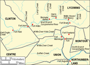
Primitive forts and smaller fortified houses gave the settlers some protection. From west to east, these included Fort Reed (at modern day Lock Haven), Fort Horn (at the mouth of Pine Creek), Antes Fort (opposite modern Jersey Shore), a fortified house near the mouth of Lycoming Creek (modern Williamsport
), the fortified Harris house near the mouth of Loyalsock Creek
(modern Montoursville
), Fort Muncy and the fortified Brady House (both near modern Muncy
), and Fort Freeland (near modern Turbotville
). As the situation worsened, more settlers moved temporarily to the forts and fortified houses. They were still vulnerable when they had to return to their homes and farms to tend to their crops and livestock.
June 10, 1778 has been called the "bloodiest day" in the history of Lycoming County, with three separate attacks on parties of settlers. Two of these attacks were along Loyalsock Creek and the third was near Lycoming Creek. In the first incident a party of twelve, including a friendly Native American and a black man, set out from the fortified Wallis house near modern Muncy to look for stolen horses. Robert Covenhoven, a guide and former soldier, was sent as a messenger to order the party's return. When the party's commander, Captain Berry, refused to turn back, Covenhoven joined the party as a guide and scout. No horses were found, and returning via the same route they had taken earlier (against the advice of Covenhoven) the party was ambushed. Some were killed immediately, six were captured (including the black man, who was burned at the stake), and Covenhoven and a few others escaped. Meanwhile a second party of three men had set out the same day from the Wallis house to retrieve cattle from the Thomson farm. They were ambushed there by a group of Native Americans and at least one Tory, with two settlers killed and the third wounded and taken prisoner. Yet another party was bringing supplies to the westernmost forts, heard the shots of this attack, but were too late to help.
Later that same day, a party of sixteen settlers on its way to Lycoming Creek were attacked in what is now Williamsport
. In what became known as the "Plum Tree Massacre", twelve of the sixteen were killed and scalped
, including two women and six children. Two girls were taken prisoner, and a boy and a girl escaped and made it to settlements on Lycoming Creek. They were so frightened by the attack that they were unable to communicate clearly where it occurred. Later search parties found all the victims of the three attacks. It was thought that all the attacks were the work of one group of Native Americans and Tories that had come south along Lycoming Creek on the Sheshequin Path
.
). A mass attack there first overwhelmed small settler forts, followed by a massacre of many of the women and children who had taken refuge there. This news caused the local authorities to order the evacuation of the whole West Branch valley.
At least two riders braved attacks to warn their fellow settlers. Rachel Silverthorn volunteered (when no man would) to leave the relative safety of Fort Muncy (in Muncy Township
). She rode along Muncy Creek
and the Wyalusing Path
and warned settlers, who fled to the safety of Fort Muncy. Her own family's cabin was later burnt to the ground. Robert Covenhoven, who had served under George Washington
in the Continental Army and survived the attacks of June 10, rode west along the ridge
of Bald Eagle Mountain
to warn settlers at Fort Antes (opposite what is now Jersey Shore
) and the western part of the valley. Covenhoven is listed as a Fair Play Man and one of the signers of the Tiadaghton Declaration of Independence.
Most settlers had already gathered at the small forts and fortified houses for safety, but now the forts and the settlers' homes and fields were abandoned, with livestock driven along and a few possessions floated on rafts on the river east to what is now Muncy
, then further south to Fort Augusta at what is now Sunbury
. Women and children rode on the rafts, while the men walked on the river bank to protect them and to drive along the livestock they had been able to save. Their abandoned property was burnt by the attackers. Some settlers reported fleeing at night with the glow of their burning settlements lighting the sky behind them.
Fort Horn and the other Fair Play Men settlements were all destroyed. In the New Purchase, only Fort Antes
(made of hard-to-burn peeled oak logs) and the stone Wallis House survived the flames. The property losses were estimated at ₤40,000, and there were deaths among the settlers. Colonel Hunter, the commander of Fort Augusta who had ordered the mass evacuation, was criticized roundly. Many at the time felt that military assistance would have allowed the settlers to withstand the attackers.
, fleeing the war there. Many of those had been poorly equipped and ill-able to withstand attacks, and simply returned to New Jersey. The government of Pennsylvania sent military aid. Colonel Thomas Hartley built Fort Muncy to protect returning settlers. On September 24, 1778 he led a force of about 200 men up the Sheshequin Path on Lycoming Creek to the North Branch of the Susquehanna to strike back against the Native Americans. Hartley's expedition covered about 300 miles (500 km) in two weeks, defeated several bands of Native Americans and destroyed a few native villages. This proved the feasibility of operating in the Iroquois territory and led to the expedition of General Sullivan the next year.
In the summer of 1779, General John Sullivan
led an expedition
that went up the North Branch of the Susquehanna and destroyed at least forty Native American villages in New York and Pennsylvania in a scorched earth campaign. The Native Americans were aware of Sullivan's plans and launched their own attack on the West Branch of the Susquehanna, hoping to draw off Sullivan or even attack him from behind. Their attacking force was discovered as it descended the Sheshequin Path along Lycoming Creek by Robert Covenhoven, sent as a scout again. The authorities ordered a second evacuation, so that those settlers who had returned did so only to flee a second time in the summer of 1779, in what became known as the "Little Runaway". The second force was about 200 Native Americans and 100 British and Tory soldiers and attacked the valley again. While the evacuation was less panicked this time, Fort Freeland (near modern Turbotville and Watsontown
) did not evacuate. It is unclear if they failed to receive the order to evacuate or ignored it, but over half of the settlers who had fled there were killed, with most of the rest taken prisoner. In any case, Sullivan's expedition and the harsh winter that followed it helped reduce attacks, stabilized the area, and encouraged resettlement. The Little Runaway and Sullivan's Expedition also led to an increased commitment by the government to the security of the frontier.
American Revolutionary War
The American Revolutionary War , the American War of Independence, or simply the Revolutionary War, began as a war between the Kingdom of Great Britain and thirteen British colonies in North America, and ended in a global war between several European great powers.The war was the result of the...
, when settlements throughout the West Branch Susquehanna Valley
West Branch Susquehanna Valley
The West Branch Susquehanna Valley of central Pennsylvania, United States, in the Ridge-and-valley Appalachians, is the low lying area draining into the West Branch Susquehanna River southeast of the Allegheny Front, northeast of the Bald Eagle Valley, southwest of the Wyoming Valley and nort of...
in Pennsylvania
Pennsylvania
The Commonwealth of Pennsylvania is a U.S. state that is located in the Northeastern and Mid-Atlantic regions of the United States. The state borders Delaware and Maryland to the south, West Virginia to the southwest, Ohio to the west, New York and Ontario, Canada, to the north, and New Jersey to...
in what became the United States
United States
The United States of America is a federal constitutional republic comprising fifty states and a federal district...
were attacked by Loyalists
Loyalist (American Revolution)
Loyalists were American colonists who remained loyal to the Kingdom of Great Britain during the American Revolutionary War. At the time they were often called Tories, Royalists, or King's Men. They were opposed by the Patriots, those who supported the revolution...
and Native Americans
Native Americans in the United States
Native Americans in the United States are the indigenous peoples in North America within the boundaries of the present-day continental United States, parts of Alaska, and the island state of Hawaii. They are composed of numerous, distinct tribes, states, and ethnic groups, many of which survive as...
allied with the British. A mass evacuation of the settlers to Fort Augusta
Fort Augusta
Fort Augusta was a stronghold in Northumberland County, Pennsylvania, in the upper Susquehanna Valley from the time of the French and Indian War to the close of the American Revolution. The fort was erected by Col...
at modern day Sunbury
Sunbury, Pennsylvania
Sunbury is a city in Northumberland County, Pennsylvania, United States. The city is located on the east bank of the Susquehanna River, just downstream of the confluence of its main and West branches. The population was 9,905 at the 2010 census...
at the confluence
Confluence (geography)
In geography, a confluence is the meeting of two or more bodies of water. It usually refers to the point where two streams flow together, merging into a single stream...
of the North and West Branches of the Susquehanna River
Susquehanna River
The Susquehanna River is a river located in the northeastern United States. At long, it is the longest river on the American east coast that drains into the Atlantic Ocean, and with its watershed it is the 16th largest river in the United States, and the longest river in the continental United...
resulted, while their abandoned houses and farms were all burnt.
Some settlers returned soon after, but the attacks and mass evacuation were repeated in 1779 as The Little Runaway. These attacks on the Pennsylvania frontier led to retaliatory scorched earth
Scorched earth
A scorched earth policy is a military strategy or operational method which involves destroying anything that might be useful to the enemy while advancing through or withdrawing from an area...
tactics by the American army against the Native Americans, including Sullivan's Expedition, which destroyed more than 40 Iroquois
Iroquois
The Iroquois , also known as the Haudenosaunee or the "People of the Longhouse", are an association of several tribes of indigenous people of North America...
villages.
Background
The lands along the West Branch Susquehanna River had been purchased by the Colonial Government of Pennsylvania from the Iroquois at the Treaty of Fort StanwixTreaty of Fort Stanwix
The Treaty of Fort Stanwix was an important treaty between North American Indians and the British Empire. It was signed in 1768 at Fort Stanwix, located in present-day Rome, New York...
in 1768 (also known as the "New Purchase"). Settlers soon began arriving in the area, and increased settlements along the West Branch of the Susquehanna helped lead to the formation of Northumberland County
Northumberland County, Pennsylvania
There were 38,835 households out of which 27.30% had children under the age of 18 living with them, 52.40% were married couples living together, 9.60% had a female householder with no husband present, and 34.10% were non-families. 30.20% of all households were made up of individuals and 15.50% had...
in 1772. The settlements along the river were in what are now parts of Northumberland, Union
Union County, Pennsylvania
-Demographics:As of the census of 2000, there were 41,624 people, 13,178 households, and 9,211 families residing in the county. The population density was 131 people per square mile . There were 14,684 housing units at an average density of 46 per square mile...
, Lycoming
Lycoming County, Pennsylvania
-Appalachian Mountains and Allegheny Plateau:Lycoming County is divided between the Appalachian Mountains in the south, the dissected Allegheny Plateau in the north and east, and the valley of the West Branch Susquehanna River between these.-West Branch Susquehanna River:The West Branch of the...
, and Clinton
Clinton County, Pennsylvania
As of the census of 2000, there were 37,914 people, 14,773 households, and 9,927 families residing in the county. The population density was 43 people per square mile . There were 18,166 housing units at an average density of 20 per square mile...
Counties.
Pine Creek (Pennsylvania)
Pine Creek is a tributary of the West Branch Susquehanna River in Potter, Tioga, Lycoming, and Clinton counties in Pennsylvania in the United States. The creek is long...
(further west, giving them more territory), while the Native Americans
Native Americans in the United States
Native Americans in the United States are the indigenous peoples in North America within the boundaries of the present-day continental United States, parts of Alaska, and the island state of Hawaii. They are composed of numerous, distinct tribes, states, and ethnic groups, many of which survive as...
said it was Lycoming Creek
Lycoming Creek
Lycoming Creek is a tributary of the West Branch Susquehanna River located in Tioga and Lycoming counties in Pennsylvania in the United States.-Geography:...
(further east). The colonial government recognized Lycoming Creek as the boundary of the "New Purchase", so settlement west of it was illegal. Despite this, there were settlers west of Lycoming Creek and west of Pine Creek about to modern day Lock Haven
Lock Haven, Pennsylvania
The city of Lock Haven is the county seat of Clinton County, in the U.S. state of Pennsylvania. Located near the confluence of the West Branch Susquehanna River and Bald Eagle Creek, it is the principal city of the Lock Haven, Pennsylvania, micropolitan statistical area, itself part of the...
. Since they were beyond the pale of the colonial government, they formed their own system of self-rule, known as the Fair Play system
Fair Play Men
The Fair Play Men were illegal settlers who established their own system of self-rule from 1773 to 1785 in the West Branch Susquehanna River valley of Pennsylvania in what is now the United States. Because they settled in territory claimed by Native Americans, they had no recourse to the...
.
American Revolutionary War
When the American Revolutionary War broke out in 1775, the settlers were nearly all for independence from Great BritainGreat Britain
Great Britain or Britain is an island situated to the northwest of Continental Europe. It is the ninth largest island in the world, and the largest European island, as well as the largest of the British Isles...
and supported the Patriot
Patriot (American Revolution)
Patriots is a name often used to describe the colonists of the British Thirteen United Colonies who rebelled against British control during the American Revolution. It was their leading figures who, in July 1776, declared the United States of America an independent nation...
cause. About 75 soldiers from the territory that became Lycoming County served in the American army, but the West Branch of the Susquehanna valley soon became a front in the war as well. According to tradition, the Fair Play Men made their own Declaration of Independence from Britain at the mouth of Pine Creek on July 4, 1776
Independence Day (United States)
Independence Day, commonly known as the Fourth of July, is a federal holiday in the United States commemorating the adoption of the Declaration of Independence on July 4, 1776, declaring independence from the Kingdom of Great Britain...
, unaware of the Continental Congress
Continental Congress
The Continental Congress was a convention of delegates called together from the Thirteen Colonies that became the governing body of the United States during the American Revolution....
' Declaration.
There had always been tensions between the settlers and natives, with some attacks, especially in the "Fair Play" area. This became more serious in the winter of 1777-1778, when two settlers were killed by Native Americans in separate incidents, and two Native Americans in a party of nine were killed by Col. Antes and his men in a skirmish after. Later a party of Native American raiders who had plundered along Buffalo Creek
Buffalo Creek (West Branch Susquehanna River)
Buffalo Creek is a tributary of the West Branch Susquehanna River in Union County, Pennsylvania, in the United States.Buffalo Creek joins the West Branch Susquehanna River at the borough of Lewisburg.-References:...
, near Lewisburg
Lewisburg, Pennsylvania
Lewisburg is a borough in Union County, Pennsylvania, United States, south by southeast of Williamsport and north of Harrisburg. In the past, it was the commercial center for a fertile grain and general farming region. The population was 5,620 at the 2000 census. It is the county seat of Union...
in Union County were stopped near modern Jersey Shore
Jersey Shore, Pennsylvania
Jersey Shore is a borough in Lycoming County, Pennsylvania, United States. It is on the West Branch Susquehanna River, west by south of Williamsport. It is part of the Williamsport, Pennsylvania Metropolitan Statistical Area. In the past, Jersey Shore held farms, railroad shops, cigar factories, a...
in Lycoming County and their booty was recovered.
The local militias were short of men (as many had joined the army), weapons, and supplies. The Supreme Executive Council of Pennsylvania was focused on supplying the army and levied taxes, which were in some cases more than the net worth of the individual settlers. Despite pleas from the settlers for more assistance, the colonial government did not send help initially, but as the West Branch Susquehanna valley became a new theater of the war, they changed their mind. On May 21, 1778 the Supreme Executive Council pledged to send the settlers "one hundred fire arms of which thirty-one are rifles" from Harris's Ferry (modern Harrisburg
Harrisburg, Pennsylvania
Harrisburg is the capital of Pennsylvania. As of the 2010 census, the city had a population of 49,528, making it the ninth largest city in Pennsylvania...
), plus another "seventy rifles [which] had been obtained from the Continental store", as well as allocating 500 pounds of lead (for bullets) and 250 pounds of gunpowder to the settlers. They also asked that General Washington
George Washington
George Washington was the dominant military and political leader of the new United States of America from 1775 to 1799. He led the American victory over Great Britain in the American Revolutionary War as commander-in-chief of the Continental Army from 1775 to 1783, and presided over the writing of...
send 250 riflemen from the army to assist the defense of the frontier. However, none of this aid arrived in time to help the settlers.
The Supreme Executive Council's decision was based on an increasing number of attacks against the settlers. On May 16, 1778 three settlers were killed by Native Americans near the mouth of Bald Eagle Creek
Bald Eagle Creek (West Branch Susquehanna River)
Bald Eagle Creek is a tributary of the West Branch Susquehanna River mostly in Centre County, Pennsylvania, in the United States. It runs through the Bald Eagle Valley at the foot of the Bald Eagle Mountain ridge to Lock Haven....
, and three men, seven women, and several children were captured by Native Americans in two attacks over the next four days. Later in May three settler families on Loyalsock Creek were wiped out: their cabins were burnt, two were killed, and fourteen disappeared, presumed captured by Native Americans. In separate incidents in late May, three settlers (a man, woman and boy) were taken prisoner near modern Linden in Woodward Township
Woodward Township, Lycoming County, Pennsylvania
Woodward Township is a township in Lycoming County, Pennsylvania, in the United States. The population was 2,397 at the 2000 census. It is part of the Williamsport, Pennsylvania Metropolitan Statistical Area.-History:...
, and three Fair Play men were killed (while one escaped) as they tried to get a boat to evacuate their families to Fort Horn at the mouth of Pine Creek. Near modern Lock Haven a skirmish led to the wounding of one Native American and one Fair Play man.
Primitive forts and smaller fortified houses gave the settlers some protection. From west to east, these included Fort Reed (at modern day Lock Haven), Fort Horn (at the mouth of Pine Creek), Antes Fort (opposite modern Jersey Shore), a fortified house near the mouth of Lycoming Creek (modern Williamsport
Williamsport, Pennsylvania
Williamsport is a city in and the county seat of Lycoming County, Pennsylvania in the United States. In 2009, the population was estimated at 29,304...
), the fortified Harris house near the mouth of Loyalsock Creek
Loyalsock Creek
Loyalsock Creek is a tributary of the West Branch Susquehanna River located chiefly in Sullivan and Lycoming counties in Pennsylvania in the United States...
(modern Montoursville
Montoursville, Pennsylvania
Montoursville is a borough in Lycoming County, Pennsylvania, in the United States. As of the 2000 census, the borough population was 4,777. It is part of the Williamsport, Pennsylvania Metropolitan Statistical Area. It was named for Madame Montour, a Native American leader and skilled interpreter...
), Fort Muncy and the fortified Brady House (both near modern Muncy
Muncy, Pennsylvania
For other places named 'Muncy', please see Muncy .Muncy is a borough in Lycoming County, Pennsylvania, in the United States. The name Muncy comes from the Munsee Indians who once lived in the area. The population was 2,663 at the 2000 census. It is part of the Williamsport, Pennsylvania...
), and Fort Freeland (near modern Turbotville
Turbotville, Pennsylvania
Turbotville is a borough in Northumberland County, Pennsylvania, United States. The population was 691 at the 2000 census.-Geography:Turbotville is located at ....
). As the situation worsened, more settlers moved temporarily to the forts and fortified houses. They were still vulnerable when they had to return to their homes and farms to tend to their crops and livestock.
June 10, 1778 has been called the "bloodiest day" in the history of Lycoming County, with three separate attacks on parties of settlers. Two of these attacks were along Loyalsock Creek and the third was near Lycoming Creek. In the first incident a party of twelve, including a friendly Native American and a black man, set out from the fortified Wallis house near modern Muncy to look for stolen horses. Robert Covenhoven, a guide and former soldier, was sent as a messenger to order the party's return. When the party's commander, Captain Berry, refused to turn back, Covenhoven joined the party as a guide and scout. No horses were found, and returning via the same route they had taken earlier (against the advice of Covenhoven) the party was ambushed. Some were killed immediately, six were captured (including the black man, who was burned at the stake), and Covenhoven and a few others escaped. Meanwhile a second party of three men had set out the same day from the Wallis house to retrieve cattle from the Thomson farm. They were ambushed there by a group of Native Americans and at least one Tory, with two settlers killed and the third wounded and taken prisoner. Yet another party was bringing supplies to the westernmost forts, heard the shots of this attack, but were too late to help.
Later that same day, a party of sixteen settlers on its way to Lycoming Creek were attacked in what is now Williamsport
Williamsport, Pennsylvania
Williamsport is a city in and the county seat of Lycoming County, Pennsylvania in the United States. In 2009, the population was estimated at 29,304...
. In what became known as the "Plum Tree Massacre", twelve of the sixteen were killed and scalped
Scalping
Scalping is the act of removing another person's scalp or a portion of their scalp, either from a dead body or from a living person. The initial purpose of scalping was to provide a trophy of battle or portable proof of a combatant's prowess in war...
, including two women and six children. Two girls were taken prisoner, and a boy and a girl escaped and made it to settlements on Lycoming Creek. They were so frightened by the attack that they were unable to communicate clearly where it occurred. Later search parties found all the victims of the three attacks. It was thought that all the attacks were the work of one group of Native Americans and Tories that had come south along Lycoming Creek on the Sheshequin Path
Sheshequin Path
The Sheshequin Path was a major Native American trail in the U.S. State of Pennsylvania that ran between two Native American villages: "French Margaret's Town" on the West Branch Susquehanna River and "Sheshequin" on the North Branch of the Susquehanna River...
.
Mass evacuation
All of these attacks and the lack of military help from the Pennsylvania government disheartened the settlers along the West Branch of the Susquehanna. In the early summer of 1778 news came of a group of Native American warriors, perhaps accompanied by Loyalist and British soldiers, heading for the West Branch Susquehanna River valley to destroy all the settlements there. This news was provided by a friendly Native American named Job Chiiloway at Fort Reed (modern Lock Haven), who was then murdered as he slept by a drunk settler engaged in target shooting. The Wyoming Valley battle and massacre occurred on July 3, 1778 (near what is now Wilkes-BarreWilkes-Barre, Pennsylvania
Wilkes-Barre is a city in the U.S. state of Pennsylvania, the county seat of Luzerne County. It is at the center of the Wyoming Valley area and is one of the principal cities in the Scranton/Wilkes-Barre metropolitan area, which had a population of 563,631 as of the 2010 Census...
). A mass attack there first overwhelmed small settler forts, followed by a massacre of many of the women and children who had taken refuge there. This news caused the local authorities to order the evacuation of the whole West Branch valley.
At least two riders braved attacks to warn their fellow settlers. Rachel Silverthorn volunteered (when no man would) to leave the relative safety of Fort Muncy (in Muncy Township
Muncy Township, Pennsylvania
Muncy Township is a township in Lycoming County, Pennsylvania, in the United States. The population was 1,059 at the 2000 census. It is part of the Williamsport, Pennsylvania Metropolitan Statistical Area.The unincorporated village of Pennsdale is located here...
). She rode along Muncy Creek
Muncy Creek
Muncy Creek is a tributary of the West Branch Susquehanna River in Lycoming and Sullivan counties, Pennsylvania, USA. Little Muncy Creek is its major tributary.-Course:The creek is long. For much of its length, U.S. Route 220 runs parallel to Muncy Creek....
and the Wyalusing Path
Wyalusing Path
The Wyalusing Path or trail was a historical trace that ran from what is now Wyalusing to the Native American village of Canaserage in Pennsylvania in the United States...
and warned settlers, who fled to the safety of Fort Muncy. Her own family's cabin was later burnt to the ground. Robert Covenhoven, who had served under George Washington
George Washington
George Washington was the dominant military and political leader of the new United States of America from 1775 to 1799. He led the American victory over Great Britain in the American Revolutionary War as commander-in-chief of the Continental Army from 1775 to 1783, and presided over the writing of...
in the Continental Army and survived the attacks of June 10, rode west along the ridge
Ridge-and-valley Appalachians
The Ridge-and-Valley Appalachians, also called the Ridge and Valley Province or the Valley and Ridge Appalachians, are a physiographic province of the larger Appalachian division and are also a belt within the Appalachian Mountains extending from southeastern New York through northwestern New...
of Bald Eagle Mountain
Bald Eagle Mountain
Bald Eagle Mountain, once known locally as Muncy Mountain, is a stratigraphic ridge in central Pennsylvania, United States, running east of the Allegheny Front and northwest of Mount Nittany. It lies along the southeast side of Bald Eagle Creek, and south of the West Branch Susquehanna River, and...
to warn settlers at Fort Antes (opposite what is now Jersey Shore
Jersey Shore, Pennsylvania
Jersey Shore is a borough in Lycoming County, Pennsylvania, United States. It is on the West Branch Susquehanna River, west by south of Williamsport. It is part of the Williamsport, Pennsylvania Metropolitan Statistical Area. In the past, Jersey Shore held farms, railroad shops, cigar factories, a...
) and the western part of the valley. Covenhoven is listed as a Fair Play Man and one of the signers of the Tiadaghton Declaration of Independence.
Most settlers had already gathered at the small forts and fortified houses for safety, but now the forts and the settlers' homes and fields were abandoned, with livestock driven along and a few possessions floated on rafts on the river east to what is now Muncy
Muncy, Pennsylvania
For other places named 'Muncy', please see Muncy .Muncy is a borough in Lycoming County, Pennsylvania, in the United States. The name Muncy comes from the Munsee Indians who once lived in the area. The population was 2,663 at the 2000 census. It is part of the Williamsport, Pennsylvania...
, then further south to Fort Augusta at what is now Sunbury
Sunbury, Pennsylvania
Sunbury is a city in Northumberland County, Pennsylvania, United States. The city is located on the east bank of the Susquehanna River, just downstream of the confluence of its main and West branches. The population was 9,905 at the 2010 census...
. Women and children rode on the rafts, while the men walked on the river bank to protect them and to drive along the livestock they had been able to save. Their abandoned property was burnt by the attackers. Some settlers reported fleeing at night with the glow of their burning settlements lighting the sky behind them.
Fort Horn and the other Fair Play Men settlements were all destroyed. In the New Purchase, only Fort Antes
Fort Antes
Fort Antes was a stockade surrounding the home of Colonel John Henry Antes, built circa 1778 in Revolutionary Pennsylvania in the United States. The fort was built under the direction of Colonel Antes, who was a member of the Pennsylvania militia...
(made of hard-to-burn peeled oak logs) and the stone Wallis House survived the flames. The property losses were estimated at ₤40,000, and there were deaths among the settlers. Colonel Hunter, the commander of Fort Augusta who had ordered the mass evacuation, was criticized roundly. Many at the time felt that military assistance would have allowed the settlers to withstand the attackers.
Aftermath
Some settlers soon returned, a few while the ruins of their homes still smoldered. Many of those who fled were recent immigrants from New JerseyNew Jersey
New Jersey is a state in the Northeastern and Middle Atlantic regions of the United States. , its population was 8,791,894. It is bordered on the north and east by the state of New York, on the southeast and south by the Atlantic Ocean, on the west by Pennsylvania and on the southwest by Delaware...
, fleeing the war there. Many of those had been poorly equipped and ill-able to withstand attacks, and simply returned to New Jersey. The government of Pennsylvania sent military aid. Colonel Thomas Hartley built Fort Muncy to protect returning settlers. On September 24, 1778 he led a force of about 200 men up the Sheshequin Path on Lycoming Creek to the North Branch of the Susquehanna to strike back against the Native Americans. Hartley's expedition covered about 300 miles (500 km) in two weeks, defeated several bands of Native Americans and destroyed a few native villages. This proved the feasibility of operating in the Iroquois territory and led to the expedition of General Sullivan the next year.
In the summer of 1779, General John Sullivan
John Sullivan
John Sullivan was the third son of Irish immigrants, a United States general in the Revolutionary War, a delegate in the Continental Congress and a United States federal judge....
led an expedition
Sullivan Expedition
The Sullivan Expedition, also known as the Sullivan-Clinton Expedition, was an American campaign led by Major General John Sullivan and Brigadier General James Clinton against Loyalists and the four nations of the Iroquois who had sided with the British in the American Revolutionary War.The...
that went up the North Branch of the Susquehanna and destroyed at least forty Native American villages in New York and Pennsylvania in a scorched earth campaign. The Native Americans were aware of Sullivan's plans and launched their own attack on the West Branch of the Susquehanna, hoping to draw off Sullivan or even attack him from behind. Their attacking force was discovered as it descended the Sheshequin Path along Lycoming Creek by Robert Covenhoven, sent as a scout again. The authorities ordered a second evacuation, so that those settlers who had returned did so only to flee a second time in the summer of 1779, in what became known as the "Little Runaway". The second force was about 200 Native Americans and 100 British and Tory soldiers and attacked the valley again. While the evacuation was less panicked this time, Fort Freeland (near modern Turbotville and Watsontown
Watsontown, Pennsylvania
Watsontown is a borough in Northumberland County, Pennsylvania, United States. The population was 2,255 at the 2000 census. It was named for John Watson, a local landowner.-Geography:Watsontown is located at ....
) did not evacuate. It is unclear if they failed to receive the order to evacuate or ignored it, but over half of the settlers who had fled there were killed, with most of the rest taken prisoner. In any case, Sullivan's expedition and the harsh winter that followed it helped reduce attacks, stabilized the area, and encouraged resettlement. The Little Runaway and Sullivan's Expedition also led to an increased commitment by the government to the security of the frontier.
Fortifications
- Fort AugustaFort AugustaFort Augusta was a stronghold in Northumberland County, Pennsylvania, in the upper Susquehanna Valley from the time of the French and Indian War to the close of the American Revolution. The fort was erected by Col...
- at the confluenceConfluence (geography)In geography, a confluence is the meeting of two or more bodies of water. It usually refers to the point where two streams flow together, merging into a single stream...
of the Susquehanna RiverSusquehanna RiverThe Susquehanna River is a river located in the northeastern United States. At long, it is the longest river on the American east coast that drains into the Atlantic Ocean, and with its watershed it is the 16th largest river in the United States, and the longest river in the continental United...
in Northumberland CountyNorthumberland County, PennsylvaniaThere were 38,835 households out of which 27.30% had children under the age of 18 living with them, 52.40% were married couples living together, 9.60% had a female householder with no husband present, and 34.10% were non-families. 30.20% of all households were made up of individuals and 15.50% had...
. This stronghold was the headquarters of the militiaMilitiaThe term militia is commonly used today to refer to a military force composed of ordinary citizens to provide defense, emergency law enforcement, or paramilitary service, in times of emergency without being paid a regular salary or committed to a fixed term of service. It is a polyseme with...
in the Susquehanna Valley. The settlers fled here during the Big Runaway. - Boone's Fort - a stockaded gristmillGristmillThe terms gristmill or grist mill can refer either to a building in which grain is ground into flour, or to the grinding mechanism itself.- Early history :...
owned by Hawkins Boone, the cousin of Daniel BooneDaniel BooneDaniel Boone was an American pioneer, explorer, and frontiersman whose frontier exploits mad']'e him one of the first folk heroes of the United States. Boone is most famous for his exploration and settlement of what is now the Commonwealth of Kentucky, which was then beyond the western borders of...
. - Fort Menninger - near the mouth of White Deer CreekWhite Deer CreekWhite Deer Creek is a tributary of the West Branch Susquehanna River in central Pennsylvania in the United States.White Deer Creek joins the West Branch Susquehanna River at White Deer.-References:...
in what is now Union CountyUnion County, Pennsylvania-Demographics:As of the census of 2000, there were 41,624 people, 13,178 households, and 9,211 families residing in the county. The population density was 131 people per square mile . There were 14,684 housing units at an average density of 46 per square mile... - Fort Freeland - in north central Northumberland County near TurbotvilleTurbotville, PennsylvaniaTurbotville is a borough in Northumberland County, Pennsylvania, United States. The population was 691 at the 2000 census.-Geography:Turbotville is located at ....
- Fort BradyFort BradyColonel Hugh Brady established Fort Brady at Sault Sainte Marie, Michigan Territory in 1822 to guard against British incursions from Canada.The garrison at the fort protected exclusive American sovereignty over the northern frontier...
- the fortified home of Capitan John Brady near MuncyMuncy, PennsylvaniaFor other places named 'Muncy', please see Muncy .Muncy is a borough in Lycoming County, Pennsylvania, in the United States. The name Muncy comes from the Munsee Indians who once lived in the area. The population was 2,663 at the 2000 census. It is part of the Williamsport, Pennsylvania...
in what is now southern Lycoming CountyLycoming County, Pennsylvania-Appalachian Mountains and Allegheny Plateau:Lycoming County is divided between the Appalachian Mountains in the south, the dissected Allegheny Plateau in the north and east, and the valley of the West Branch Susquehanna River between these.-West Branch Susquehanna River:The West Branch of the...
. - Fort Muncy - the fortified home of Samuel WallisSamuel WallisSamuel Wallis was a Cornish navigator who circumnavigated the world.Wallis was born near Camelford, Cornwall. In 1766 he was given the command of HMS Dolphin to circumnavigate the world, accompanied by the Swallow under the command of Philip Carteret...
in what is now Muncy Township just a few miles from Fort Brady. - Harris HouseHarris HouseHarris House may refer to:in the United States* Harris House , listed on the NRHP in Pulaski County, Arkansas* Harris House , listed on the NRHP in Little Rock, Arkansas*W.C...
- a fortified home near the mouth of Loyalsock CreekLoyalsock CreekLoyalsock Creek is a tributary of the West Branch Susquehanna River located chiefly in Sullivan and Lycoming counties in Pennsylvania in the United States...
also in Lycoming County. - Stockade Started - this stockadeStockadeA stockade is an enclosure of palisades and tall walls made of logs placed side by side vertically with the tops sharpened to provide security.-Stockade as a security fence:...
was never completed. It was along Lycoming CreekLycoming CreekLycoming Creek is a tributary of the West Branch Susquehanna River located in Tioga and Lycoming counties in Pennsylvania in the United States.-Geography:...
in the west end of WilliamsportWilliamsport, PennsylvaniaWilliamsport is a city in and the county seat of Lycoming County, Pennsylvania in the United States. In 2009, the population was estimated at 29,304... - Fort AntesFort AntesFort Antes was a stockade surrounding the home of Colonel John Henry Antes, built circa 1778 in Revolutionary Pennsylvania in the United States. The fort was built under the direction of Colonel Antes, who was a member of the Pennsylvania militia...
- a stockade surrounding the fortified home of Colonel John Henry Antes in Nippenose Township south of modern Jersey ShoreJersey Shore, PennsylvaniaJersey Shore is a borough in Lycoming County, Pennsylvania, United States. It is on the West Branch Susquehanna River, west by south of Williamsport. It is part of the Williamsport, Pennsylvania Metropolitan Statistical Area. In the past, Jersey Shore held farms, railroad shops, cigar factories, a...
. - Fort Horn - at the mouth of Pine CreekPine Creek (Pennsylvania)Pine Creek is a tributary of the West Branch Susquehanna River in Potter, Tioga, Lycoming, and Clinton counties in Pennsylvania in the United States. The creek is long...
in eastern Clinton CountyClinton County, PennsylvaniaAs of the census of 2000, there were 37,914 people, 14,773 households, and 9,927 families residing in the county. The population density was 43 people per square mile . There were 18,166 housing units at an average density of 20 per square mile... - Fort Reid - at the mouth of Bald Eagle CreekBald Eagle Creek (West Branch Susquehanna River)Bald Eagle Creek is a tributary of the West Branch Susquehanna River mostly in Centre County, Pennsylvania, in the United States. It runs through the Bald Eagle Valley at the foot of the Bald Eagle Mountain ridge to Lock Haven....
near modern day Lock HavenLock Haven, PennsylvaniaThe city of Lock Haven is the county seat of Clinton County, in the U.S. state of Pennsylvania. Located near the confluence of the West Branch Susquehanna River and Bald Eagle Creek, it is the principal city of the Lock Haven, Pennsylvania, micropolitan statistical area, itself part of the...
in Clinton County, PennsylvaniaClinton County, PennsylvaniaAs of the census of 2000, there were 37,914 people, 14,773 households, and 9,927 families residing in the county. The population density was 43 people per square mile . There were 18,166 housing units at an average density of 20 per square mile...
.