
.gif)
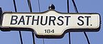
Bathurst Street (Toronto)
Encyclopedia
Toronto
Toronto is the provincial capital of Ontario and the largest city in Canada. It is located in Southern Ontario on the northwestern shore of Lake Ontario. A relatively modern city, Toronto's history dates back to the late-18th century, when its land was first purchased by the British monarchy from...
. It begins at the Lake Ontario
Lake Ontario
Lake Ontario is one of the five Great Lakes of North America. It is bounded on the north and southwest by the Canadian province of Ontario, and on the south by the American state of New York. Ontario, Canada's most populous province, was named for the lake. In the Wyandot language, ontarío means...
shoreline and continues north to the Toronto boundary of Steeles Avenue
Steeles Avenue
Steeles Avenue is an east-west street that forms the northern city limit of Toronto and the southern limit of York Region, Ontario, Canada. It stretches across the western Greater Toronto Area from Milborough Townline in Halton Region east to the Scarborough-Pickering limit. It runs for within...
. The roadway continues north into York Region where it is known as York Regional Road 38.
Route description
Bathurst Street begins in the south at the shore of Lake OntarioLake Ontario
Lake Ontario is one of the five Great Lakes of North America. It is bounded on the north and southwest by the Canadian province of Ontario, and on the south by the American state of New York. Ontario, Canada's most populous province, was named for the lake. In the Wyandot language, ontarío means...
, separated by the Western Gap shipping channel from Toronto City Centre Airport
Toronto City Centre Airport
Billy Bishop Toronto City Airport , commonly known as the Toronto Island Airport is an airport located on the Toronto Islands in Toronto, Ontario, Canada. It is named after Air Marshal Billy Bishop, a Canadian First World War flying ace...
. The southernmost part of Bathurst, south of the Gardiner Expressway
Gardiner Expressway
The Frederick G. Gardiner Expressway, colloquially referred to as "the Gardiner", is a municipal expressway in the Canadian province of Ontario, connecting downtown Toronto with its western suburbs...
, was heavily industrialized until the 1970s. These factories are mostly gone; in their place some residential development has occurred, including the extended Queen's Quay
Queen's Quay (Toronto)
Queen's Quay is a prominent street in the Harbourfront neighbourhood of Toronto, Ontario, Canada. The street was originally commercial in nature due to the many working piers along the waterfront...
. The former Omni Television
OMNI Television
Omni Television, corporately styled as OMNI Television, is a Canadian television system owned and operated by Rogers Communications. It consists of the company's conventional television stations in Ontario, British Columbia and Alberta which are licensed as multicultural stations...
headquarters are located in this area, before they relocated in October, 2008. The section south of Queen's Quay is also known as Eireann Quay.
North of the Gardiner is Fort York
Fort York
Fort York is a historic site of military fortifications and related buildings on the west side of downtown Toronto, Ontario, Canada. The fort was built by the British Army and Canadian militia troops in the late 18th and early 19th centuries, to defend the settlement and the new capital of the...
and the beginning of a mix of small commercial and residential buildings on the western fringe of downtown. North of Queen Street, the eastern side of Bathurst is the edge of the Alexandria Park cluster of housing projects, while to the west is Trinity-Bellwoods. North of Dundas Street, Bathurst is dominated by Toronto Western Hospital
Toronto Western Hospital
-External links:****...
. This part of the street continues to be a mix of small commercial establishments and residential housing, generally in the form of rental apartments.
North of College Street
College Street (Toronto)
College Street is a principal arterial thoroughfare in downtown Toronto, connecting former streetcar suburbs in the west with the city centre. The street is home to an ethnically diverse population in the western residential reaches, and institutions like the Ontario Legislature and the University...
, Bathurst becomes more residential, with the exception of certain areas, chiefly around the intersections with Bloor Street
Bloor Street
Bloor Street is a major east–west residential and commercial thoroughfare in Toronto, in the Canadian province of Ontario. Bloor Street runs from the Prince Edward Viaduct westward into Mississauga, where it ends at Central Parkway. East of the viaduct, Danforth Avenue continues along the same...
, St. Clair Avenue
St. Clair Avenue
St. Clair Avenue is a major east-west street in Toronto, Ontario, Canada. It was laid out in the late 18th century by the British as a concession road , north of Bloor Street and north of Queen Street....
, and Eglinton Avenue
Eglinton Avenue
Eglinton Avenue, originally known as the Richview Sideroad within Etobicoke, is an east-west arterial thoroughfare in Toronto and Mississauga, in the Canadian province of Ontario. Within Toronto, Eglinton Avenue is the only road which crosses through all six former boroughs...
. The portion of Bathurst Street north of Bloor Street is the western boundary of The Annex
The Annex
The Annex is a neighbourhood in downtown Toronto, Ontario, Canada. The traditional boundaries of the neighbourhood are north to Dupont Street, south to Bloor Street, west to Bathurst Street and east to Avenue Road...
neighbourhood.
The TTC Spadina line crosses underneath Bathurst at St. Clair, with the St. Clair West station located at St. Clair and Bathurst. North of Eglinton, the street continues as a four-lane arterial road into the former borough of North York. The street has lay-bys for TTC buses and turning lanes at intersections, expanding its width. Development along both sides of the road is both residential and commercial, with shopping plazas at many intersections. The West Branch of the Don River crosses Bathurst Street north of Sheppard and Bathurst Park is located on the east side of Bathurst Street.
North of Steeles Avenue
Steeles Avenue
Steeles Avenue is an east-west street that forms the northern city limit of Toronto and the southern limit of York Region, Ontario, Canada. It stretches across the western Greater Toronto Area from Milborough Townline in Halton Region east to the Scarborough-Pickering limit. It runs for within...
, Bathurst runs through York Region, and is also referred to as York Regional Road 38. From Steeles north, the road is a six-lane arterial road. It serves numerous residential sub-divisions on either side.It serves as the boundary between Vaughan
Vaughan, Ontario
Vaughan is a city in York Region north of Toronto, Ontario, Canada. Vaughan is the fastest growing municipality in Canada achieving a population growth rate of 80.2% between 1996–2006, according to Statistics Canada having nearly doubled in population since 1991. Vaughan is located in Southern...
and Richmond Hill north of Highway 407, as well as King Township
King, Ontario
King is a township in York Region north of Toronto, within the Greater Toronto Area in Ontario, Canada.The rolling hills of the Oak Ridges Moraine are the most prominent visible geographical feature of King. The Holland Marsh, considered to be Ontario's "vegetable basket", straddles King Township...
and both Newmarket
Newmarket, Ontario
Newmarket is a town in Southern Ontario located approximately 50 km north of downtown Toronto, Ontario, Canada. It is part of the Greater Toronto Area and is connected to Toronto by freeway, and is served by three interchanges along Highway 404. It is also connected to Highway 400 via Highway 9...
and Aurora
Aurora, Ontario
Aurora is an affluent town in York Region, approximately 20 km north of Toronto. It is partially situated on the Oak Ridges Moraine, and is a part of the Greater Toronto Area and Golden Horseshoe of Southern Ontario.Many Aurora residents commute to Toronto and surrounding communities.In the...
.
Bathurst Street ends at the Holland Marsh
Holland Marsh
The Holland Marsh is a wetland and agricultural area north of Toronto, Ontario. It lies entirely within the valley of the Holland River, stretching from the northern edge of the Oak Ridges Moraine near Schomberg to the river mouth at Cook's Bay, Lake Simcoe. In its entirety it comprises about or...
, between Holland Landing
Holland Landing, Ontario
Holland Landing is a village in the town of East Gwillimbury, located in the northern part of the Regional Municipality of York, in south-central Ontario, Canada. Its major road is Yonge Street and the village has bus service by GO Transit and York Region Transit...
(in East Gwillimbury
East Gwillimbury, Ontario
East Gwillimbury is a town on the East Holland River in the Regional Municipality of York. It is part of the Greater Toronto Area of south-central Ontario, in Canada. It was formed by the amalgamation of the Township of East Gwillimbury with all the previously incorporated villages and hamlets...
) and Bradford
Bradford West Gwillimbury, Ontario
Bradford West Gwillimbury, a town in south-central Ontario, in the County of Simcoe in the Greater Toronto Area on the Holland River. West Gwillimbury takes its name from the family of Elizabeth Simcoe, née Gwillim....
. It is interrupted for roughly 500 m due to rugged terrain north of Morning Sideroad, north of Newmarket
Newmarket, Ontario
Newmarket is a town in Southern Ontario located approximately 50 km north of downtown Toronto, Ontario, Canada. It is part of the Greater Toronto Area and is connected to Toronto by freeway, and is served by three interchanges along Highway 404. It is also connected to Highway 400 via Highway 9...
.
History
Henry Bathurst, 3rd Earl Bathurst
Henry Bathurst, 3rd Earl Bathurst KG PC was a British politician.-Background and education:Lord Bathurst was the elder son of Henry Bathurst, 2nd Earl Bathurst, by his wife Tryphena, daughter of Thomas Scawen...
, who organized migration from the British Isles to Canada after the War of 1812, granted the charter to King's College
University of Toronto
The University of Toronto is a public research university in Toronto, Ontario, Canada, situated on the grounds that surround Queen's Park. It was founded by royal charter in 1827 as King's College, the first institution of higher learning in Upper Canada...
, and never visited Canada himself.
The original Bathurst Street was between Government Wharf and Queen Street
Queen Street West
Queen Street West describes both the western branch of Queen Street, a major east-west thoroughfare, and a series of neighbourhoods or commercial districts, situated west of Yonge Street in downtown Toronto, Ontario, Canada. Queen Street begins in the west at the intersection of King Street, The...
, and the section to the north was called Crookshank's Lane, a semi-private lane named after George Crookshank. In 1870, Crookshank's Lane was renamed to Bathurst Street. North of Bloor, Bathurst Street was a muddy trail.
Bathurst Street has finished in the top 10 in CAA
Canadian Automobile Association
The Canadian Automobile Association , commonly known as CAA, is a non-profit federation, founded in 1913, of nine clubs across Canada, providing roadside assistance service, a complete range of auto touring and leisure travel services, insurance services, and member discounts with preferred...
's Ontario's Worst Roads poll in every year from 2004 to 2007.
Jewish Community
Bathurst Street has been the heart of the Jewish community of TorontoJewish Community of Toronto
The history of the Jews in Toronto, Ontario, Canada goes back to the early 19th century.Since the 1970s, Toronto's Jewish population has been the largest in Canada and the centre of Jewish Canadian culture...
for many decades. From the early part of the twentieth century, many Jews lived around Bathurst Street south of Bloor Street
Bloor Street
Bloor Street is a major east–west residential and commercial thoroughfare in Toronto, in the Canadian province of Ontario. Bloor Street runs from the Prince Edward Viaduct westward into Mississauga, where it ends at Central Parkway. East of the viaduct, Danforth Avenue continues along the same...
east to Spadina Avenue
Spadina Avenue
Spadina Avenue is one of the most prominent streets in Toronto, Ontario, Canada. Running through the western section of downtown, the road has a very different character in different neighbourhoods....
(and particularly Kensington Market
Kensington Market
Kensington Market is a distinctive multicultural neighbourhood in Downtown Toronto, Ontario, Canada. The Market is an older neighbourhood and one of the city's most well-known. In November 2006, it was designated a National Historic Site of Canada. Robert Fulford wrote in 1999 that "Kensington...
) and west to past Christie Pits
Christie Pits
Christie Pits Park, originally Willowvale Park, is a Toronto public recreational area located at 750 Bloor Street West at Christie Street, just west from the TTC Christie subway station...
. After World War II, as the community became more middle class
Middle class
The middle class is any class of people in the middle of a societal hierarchy. In Weberian socio-economic terms, the middle class is the broad group of people in contemporary society who fall socio-economically between the working class and upper class....
, it moved north along Bathurst Street, with wealthier members of the community moving to Forest Hill
Forest Hill, Toronto
Forest Hill is an affluent neighbourhood in central Toronto, Ontario, Canada. Along with Lawrence Park, Rosedale, and The Bridle Path, it is one of Toronto’s wealthiest neighbourhoods.-History:...
. The poorer members moved to the area around Bathurst and St. Clair Avenue
St. Clair Avenue
St. Clair Avenue is a major east-west street in Toronto, Ontario, Canada. It was laid out in the late 18th century by the British as a concession road , north of Bloor Street and north of Queen Street....
or Bathurst and Eglinton Avenue
Eglinton Avenue
Eglinton Avenue, originally known as the Richview Sideroad within Etobicoke, is an east-west arterial thoroughfare in Toronto and Mississauga, in the Canadian province of Ontario. Within Toronto, Eglinton Avenue is the only road which crosses through all six former boroughs...
.
The community continued to move north along Bathurst and today, much of the Jewish community resides along the street from north of St. Clair Avenue
St. Clair Avenue
St. Clair Avenue is a major east-west street in Toronto, Ontario, Canada. It was laid out in the late 18th century by the British as a concession road , north of Bloor Street and north of Queen Street....
and, in higher concentrations just south of Lawrence Avenue
Lawrence Avenue
Lawrence Avenue is a major east-west thoroughfare in Toronto, Ontario, Canada. It is divided into east and west portions by Yonge Street, the dividing line of east-west streets in Toronto....
to beyond the city limits at Steeles Avenue
Steeles Avenue
Steeles Avenue is an east-west street that forms the northern city limit of Toronto and the southern limit of York Region, Ontario, Canada. It stretches across the western Greater Toronto Area from Milborough Townline in Halton Region east to the Scarborough-Pickering limit. It runs for within...
, and extending further until about Elgin Mills Road in Richmond Hill
Richmond Hill, Ontario
Richmond Hill is a town located in Southern Ontario, Canada in the central portion of York Region, Ontario. It is part of the Greater Toronto Area, being located about halfway between Toronto and Lake Simcoe...
. Many synagogue
Synagogue
A synagogue is a Jewish house of prayer. This use of the Greek term synagogue originates in the Septuagint where it sometimes translates the Hebrew word for assembly, kahal...
s are located on Bathurst, as well as many other Jewish community institutions:
The northern stretch of Bathurst, north of Sheppard Avenue
Sheppard Avenue
Sheppard Avenue is an east-west principal arterial road in Toronto, Ontario, Canada. A small portion of a continuation of the road in Pickering, Ontario is also called Sheppard Avenue.-History:...
West, has become one of the centres of the Russian community in Toronto. Many Russian Jewish immigrants started to settle in the apartment buildings there (many are located around the Bathurst/Sheppard intersection, as well as a long stretch of Bathurst between Finch Ave. West and Steeles Ave. West) , starting from early 1970s in order to get easier access to services provided by the Jewish Immigrant Aid Society. Following the breakup of the Soviet Union, significant numbers of Russian immigrants to Canada
Canada
Canada is a North American country consisting of ten provinces and three territories. Located in the northern part of the continent, it extends from the Atlantic Ocean in the east to the Pacific Ocean in the west, and northward into the Arctic Ocean...
settled there. Many are affiliated with the Jewish Russian Community centre. The electoral district of York Centre
York Centre
York Centre is a federal electoral district in Ontario, Canada, that has been represented in the Canadian House of Commons from 1904 to 1917 and since 1953....
, which includes Bathurst from Wilson Ave. West to Steeles Ave. West, has the largest number of Russo-Canadian voters in Canada. Numerous Russian delicatessens, restaurants, and book and clothing stores have earned the neighbourhood the unofficial moniker Little Moscow.
Public transit
Bathurst StationBathurst (TTC)
Bathurst is a station on the Bloor–Danforth line of the subway system in Toronto, Canada. It is located at 565 Bloor Street West at Bathurst Street. It was opened in 1966...
is a Toronto Transit Commission
Toronto Transit Commission
-Island Ferry:The ferry service to the Toronto Islands was operated by the TTC from 1927 until 1962, when it was transferred to the Metro Parks and Culture department. Since 1998, the ferry service is run by Toronto Parks and Recreation.-Gray Coach:...
subway station located at Bathurst Street and Bloor Street
Bloor Street
Bloor Street is a major east–west residential and commercial thoroughfare in Toronto, in the Canadian province of Ontario. Bloor Street runs from the Prince Edward Viaduct westward into Mississauga, where it ends at Central Parkway. East of the viaduct, Danforth Avenue continues along the same...
. The 511 Bathurst streetcar route
Toronto streetcar system
The Toronto streetcar system comprises eleven streetcar routes in Toronto, Ontario, Canada, operated by the Toronto Transit Commission , and is the largest such system in the Americas in terms of ridership, number of cars, and track length. The network is concentrated primarily in downtown and in...
runs from Bloor to Fleet Street, where it turns to connect to Exhibition Place
Exhibition Place
Exhibition Place is a mixed-use district in Toronto, Ontario, Canada, by the shoreline of Lake Ontario, just west of downtown. The 197–acre area includes expo, trade, and banquet centres, theatre and music buildings, monuments, parkland, sports facilities, and a number of civic, provincial,...
. The short section of Bathurst south from Fleet Street to Queen's Quay is used by the mainly east-west 509 Harbourfront
509 Harbourfront
509 Harbourfront is a streetcar route in Toronto, Ontario, Canada, operated by the Toronto Transit Commission.-History:The Harbourfront LRT, originally designated 604 Harbourfront, began service in 1990...
streetcar.
North of Bathurst Station, public transit is provided by the bus routes 7 Bathurst up to Steeles Avenue
Steeles Avenue
Steeles Avenue is an east-west street that forms the northern city limit of Toronto and the southern limit of York Region, Ontario, Canada. It stretches across the western Greater Toronto Area from Milborough Townline in Halton Region east to the Scarborough-Pickering limit. It runs for within...
, and 160 Bathurst North up to New Westminster Drive and Atkinson Avenue. During overnight hours when the subway is closed, the bus route 310 Bathurst Blue Night
Blue Night Network
The Blue Night Network is the overnight public transit service operated by the Toronto Transit Commission in Toronto, Ontario, Canada. The network consists of a basic grid of 22 bus and 2 streetcar routes, distributed so that almost all of the city is within 2 km of at least one...
covers the Bathurst streetcar route.
Although not used in normal service, the streetcar tracks also continue along Bathurst (the southbound track briefly using Vaughan Road) as far as St. Clair Avenue
St. Clair Avenue
St. Clair Avenue is a major east-west street in Toronto, Ontario, Canada. It was laid out in the late 18th century by the British as a concession road , north of Bloor Street and north of Queen Street....
to connect the TTC's Hillcrest Complex and the 512 St. Clair streetcar to the rest of the streetcar network.
York Region Transit
York Region Transit
York Region Transit is the public transit operator in York Region, Ontario, Canada. Its headquarters are in Richmond Hill, at 50 High Tech Road....
(YRT) runs several routes along Bathurst Street, including the 88 Bathurst from Finch Bus Terminal to Seneca College
Seneca College
Seneca College of Applied Arts and Technology is a Canadian public college in the greater Toronto area. Seneca College is currently Canada's largest college with approximately 108,000 students.-History:...
King Campus, part of Viva Purple
Viva Purple
Viva Purple, or the York University/Richmond Hill/Cornell line, is a line on the Viva bus rapid transit system in York Region, north of Toronto, Canada...
, 90 Leslie South, and other connections at the Promenade Terminal.
Points of interest
The most notable attraction on Bathurst Street is the legendary bargain goods emporium Honest Ed'sHonest Ed's
Honest Ed's is a landmark discount store located in Toronto, Ontario, Canada. It is named for its proprietor, Ed Mirvish, who opened the store in 1948 and oversaw its operations for almost sixty years, until his death in 2007.-Location:...
, located at Bloor Street
Bloor Street
Bloor Street is a major east–west residential and commercial thoroughfare in Toronto, in the Canadian province of Ontario. Bloor Street runs from the Prince Edward Viaduct westward into Mississauga, where it ends at Central Parkway. East of the viaduct, Danforth Avenue continues along the same...
. Other attractions along Bathurst include:
- TTC's Hillcrest Complex
- Lawrence PlazaLawrence PlazaLawrence Plaza is a shopping centre in Canada located on the northwest corner of Bathurst Street and Lawrence Avenue West in Toronto.-History:It was built around 1953 and was visited by Queen Elizabeth II in the 1950s....
- Cedarvale ParkCedarvale Park (Toronto)Cedarvale Park is a park located in Toronto, Ontario, Canada. It is bordered by very steep hills, and is located in the Cedarvale neighbourhood of Toronto. The Spadina subway line tunnels underneath it, between St. Clair West and Eglinton West stations...
- Baycrest Geriatric Centre
- Cineforum
- Lawrence ManorLawrence ManorLawrence Manor is a neighbourhood in the city of Toronto, Ontario, Canada. The neighbourhood is bounded by Bathurst Street on the east, Highway 401 to the north, the Allen to the west, and Lawrence Avenue to the south...
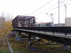
- Bathurst Street BridgeBathurst Street BridgeThe Bathurst Street Bridge is a bridge in Toronto, Ontario, Canada. It carries four lanes for motor vehicles with Toronto Transit Commission 's streetcar tracks along Bathurst Street over the railway tracks south of Front Street...
- Little Norway ParkLittle Norway ParkLittle Norway Park is a small park located in downtown Toronto, Canada at the southwest corner of Bathurst Street and Queen's Quay West.A totem pole is located near Queen's Quay West on the park property....
- Toronto Western HospitalToronto Western Hospital-External links:****...
- Airport Ferry Docks
- Earl Bales Park
- Holocaust Memorial
- Raoul Wallenberg Road
- Esther Shiner StadiumEsther Shiner StadiumEsther Shiner Stadium is a multi-purpose outdoor sports facility in Toronto, Ontario, Canada. It is located in North York, on the north-west corner of Bathurst Street and Finch Avenue West...
- The Promenade Shopping CentreThe Promenade Shopping CentreThe Promenade Shopping Centre is a shopping mall, located on Bathurst Street and Centre Street in the area of Thornhill in Vaughan, Ontario. It opened on August 4, 1986...
- Bathurst Bowlerama
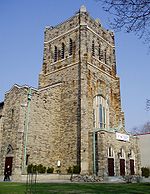
- Bathurst Street TheatreBathurst Street TheatreThe Bathurst Street Theatre is a theatre in Toronto, Ontario, that is housed in a former church. The Gothic revival building is located at 736 Bathurst Street at Lennox, one traffic light to the south of Bloor Street, Honest Ed's, the Bathurst Street Subway Station, and across Bathurst from...
- College Street United ChurchCollege Street United ChurchCollege Street United Church is a United Church of Canada church at the corner of College and Bathurst Streets in Toronto, Canada. The large church was built in 1885 as College Street Presbyterian and could hold 1200 worshippers, under founding minister Alexander Gilray , and Robert Balmer Cochrane...
- Central Technical SchoolCentral Technical SchoolCentral Technical School is a composite high school located at 725 Bathurst Street at Harbord Street in Toronto, Canada.C.T.S. offers a wide range of programs, including all core academic courses, as well as concentration and specialization in visual arts and technical studies. C.T.S...
- St. Michael's College SchoolSt. Michael's College SchoolSt. Michael's College School is a private, all-boys Roman Catholic day school in Toronto, Canada. Currently administered by the Basilian Fathers, it is the largest school of its kind in Canada, with an enrollment of approximately 1,080 students from grades 7 to 12. St...
- Westmount Collegiate InstituteWestmount Collegiate InstituteWestmount Collegiate Institute is a high school in the Thornhill, Ontario district of the greater city of Vaughan. It opened its doors in 1996, as part of the multi-purpose Benjamin Vaughan Complex, named for Benjamin Vaughan, the diplomat for which the city is named...
External links
- Bathurst Street at Google MapsGoogle MapsGoogle Maps is a web mapping service application and technology provided by Google, free , that powers many map-based services, including the Google Maps website, Google Ride Finder, Google Transit, and maps embedded on third-party websites via the Google Maps API...