

St. Clair Avenue
Encyclopedia
Toronto
Toronto is the provincial capital of Ontario and the largest city in Canada. It is located in Southern Ontario on the northwestern shore of Lake Ontario. A relatively modern city, Toronto's history dates back to the late-18th century, when its land was first purchased by the British monarchy from...
, Ontario
Ontario
Ontario is a province of Canada, located in east-central Canada. It is Canada's most populous province and second largest in total area. It is home to the nation's most populous city, Toronto, and the nation's capital, Ottawa....
, Canada
Canada
Canada is a North American country consisting of ten provinces and three territories. Located in the northern part of the continent, it extends from the Atlantic Ocean in the east to the Pacific Ocean in the west, and northward into the Arctic Ocean...
. It was laid out in the late 18th century by the British as a concession road
Concession road
In Upper and Lower Canada, concession roads were laid out by the colonial government through undeveloped land to define lots to be developed; the name comes from a Lower Canadian French term for a row of lots. Concession roads are straight, and follow an approximately square grid, usually oriented...
(the Third Concession), 2 kilometres (1.2 mi) north of Bloor Street
Bloor Street
Bloor Street is a major east–west residential and commercial thoroughfare in Toronto, in the Canadian province of Ontario. Bloor Street runs from the Prince Edward Viaduct westward into Mississauga, where it ends at Central Parkway. East of the viaduct, Danforth Avenue continues along the same...
and 4 kilometres (2.5 mi) north of Queen Street
Queen Street West
Queen Street West describes both the western branch of Queen Street, a major east-west thoroughfare, and a series of neighbourhoods or commercial districts, situated west of Yonge Street in downtown Toronto, Ontario, Canada. Queen Street begins in the west at the intersection of King Street, The...
.
St. Clair Avenue has two sections. The western section extends from Moore Park
Moore Park, Toronto
Moore Park is a neighbourhood in Toronto, Ontario, Canada. It lies along both sides of St. Clair Avenue East between the Vale of Avoca section of Rosedale ravine and Moore Park ravine . The northern boundary is Mount Pleasant Cemetery and the southern the Canadian Pacific Railway tracks.The...
in the east to Scarlett Road in the west, a distance of approximately 10 kilometres (6.2 mi). An eastern section picks up on the far side of the Don Valley at Taylor Creek Park, extending for 7 kilometres (4.3 mi) to Kingston Road
Kingston Road (Toronto)
Kingston Road is the southernmost major road along the eastern portion of Toronto, specifically in the districts of East York and Scarborough. Until 1998, it formed a significant portion of Highway 2...
. Like all streets in Toronto which cross Yonge Street
Yonge Street
Yonge Street is a major arterial route connecting the shores of Lake Ontario in Toronto to Lake Simcoe, a gateway to the Upper Great Lakes. It was formerly listed in the Guinness Book of Records as the longest street in the world at , and the construction of Yonge Street is designated an "Event of...
, St. Clair is divided into separate East and West sections, each with its own street numbers beginning at Yonge Street. Unlike other concession roads in Toronto, St. Clair does not extend west into Etobicoke.
St. Clair Avenue West has heavy automotive
Automobile
An automobile, autocar, motor car or car is a wheeled motor vehicle used for transporting passengers, which also carries its own engine or motor...
and public transit
Public transport
Public transport is a shared passenger transportation service which is available for use by the general public, as distinct from modes such as taxicab, car pooling or hired buses which are not shared by strangers without private arrangement.Public transport modes include buses, trolleybuses, trams...
traffic. Over half the commuters in rush hour traffic travel by streetcar. The 512 St. Clair streetcar line connects with St. Clair
St. Clair (TTC)
St. Clair is a station on the Yonge–University–Spadina line of the subway system in Toronto, Ontario, Canada. Its address is 1441 Yonge Street, at the intersection with St. Clair Avenue East, but its street entrances are on St. Clair and on Pleasant Boulevard. The station's site has no frontage on...
and St. Clair West
St. Clair West (TTC)
St. Clair West is a station on the Yonge–University–Spadina line of the subway system in Toronto, Ontario, Canada. It is at 370 St. Clair Avenue West between Bathurst Street and Tweedsmuir Avenue. The sports field of St. Michael's College School is directly above the length of the station; a...
subway stations on the Yonge-University-Spadina subway line.
Name
Uncle Tom's Cabin
Uncle Tom's Cabin; or, Life Among the Lowly is an anti-slavery novel by American author Harriet Beecher Stowe. Published in 1852, the novel "helped lay the groundwork for the Civil War", according to Will Kaufman....
. The Grainger family who rented a farm near the present-day intersection of Avenue Road and St. Clair. After viewing a stage production of Uncle Tom's Cabin, two members of the family, Albert and Edwin, adopted names of two characters as their middle names as each boy had no given middle name. Edwin added Norton to his name, and Albert chose St. Clare, although he used the incorrect spelling of St. Clair, as it was used in the theatre program. (Lake St. Clair and the St. Clair River also use the incorrect spelling) As a joke, Edwin and Albert made street signs using their names and posted them at Yonge and St. Clair. The St. Clair sign survived for a while and the name became adopted as the name for the 3rd Concession Road. The first known printed use of the St. Clair name was in an 1878 publication, Illustrated Historical Atlas of the County of York.
In 1913, the first Roman Catholic church in the area was built, and named after the actual Saint Clare
Clare of Assisi
Clare of Assisi , born Chiara Offreduccio, is an Italian saint and one of the first followers of Saint Francis of Assisi...
. St. Clare's Church is at 1118 St. Clair Avenue West, on the north side of the street, east of Dufferin. The parish opened the St. Clare's Catholic School, an elementary school, next door in 1916.
History
The first European settlement on St. Clair was at Yonge Street, where the Heath family bought land in 1837. A thriving neighbourhood, Deer ParkDeer Park, Toronto
Deer Park is a neighbourhood in Toronto, Ontario, Canada, centred on the intersection of Yonge Street and St. Clair Avenue; its boundaries are the Vale of Avoca section of Rosedale ravine in the east, Farnham Avenue and Jackes Avenue in the south, Avenue Road and Oriole Parkway in the west, the...
, was established by the 1850s. The next settlement was about 5.5 km (3.4 mi) west, at Old Weston Road (then Weston Road), where settlement of Carlton Village began in the late 1840s. The western end of St. Clair experienced substantial development, with the municipalities of West Toronto, Earlscourt, Dovercourt, and Oakwood established there.
These municipalities were annexed by Toronto between 1908 and 1911, and the western section of St. Clair Avenue became entirely managed by the City of Toronto. To stimulate development along what was then largely a rural road, the city's Toronto Civic Railways
Toronto Civic Railways
Toronto Civic Railways was an agency created and owned by the City of Toronto, Canada, to run streetcars in newly annexed areas of the city that the private operator Toronto Railway Company refused to serve...
built a streetcar
Tram
A tram is a passenger rail vehicle which runs on tracks along public urban streets and also sometimes on separate rights of way. It may also run between cities and/or towns , and/or partially grade separated even in the cities...
line from Yonge Street to Caledonia Road by 1912. This included the construction of an earth berm
Berm
A berm is a level space, shelf, or raised barrier separating two areas. Berm originates in the Middle Dutch and German berme and came into usage in English via French.- History :...
across Nordheimer Ravine
Castle Frank Brook
Castle Frank Brook is a buried creek and south-west flowing tributary of the Don River in central and north-western Toronto, Ontario, originating near the intersection of Lawrence Avenue and Dufferin Street....
as well as what was termed the Lauder Fill: the burying of the western branch of Garrison Creek
Garrison Creek
Garrison Creek was a short stream about long that flowed southeast into the west side of Toronto Harbour in Ontario, Canada.It has been largely covered over and filled in, but geographical traces of the creek can still be found. The natural amphitheatre known as Christie Pits is one such remnant;...
, the final section to be routed into the city's stormwater system.
The growth of the inner suburbs of Leaside, Rosedale and Moore Park prompted the city of Toronto to approach the operators of Mount Pleasant Cemetery
Mount Pleasant Cemetery, Toronto
Mount Pleasant Cemetery is a cemetery located in Toronto, Ontario, Canada.In the early 19th century, the only authorized cemeteries within the city of Toronto were limited to the members of either the Roman Catholic Church or the Church of England...
in 1912 with the goal of extending the short Mount Pleasant Road south through the cemetery to connect with St. Clair. Though the operators initially refused, they later accepted the city's offer of $100,000 ($2,095,000, adjusted for inflation) in 1915. The muddy road was opened to traffic in 1918. The construction of the Vale of Avoca through the first half of the 1920s prompted the new Toronto Transit Commission
Toronto Transit Commission
-Island Ferry:The ferry service to the Toronto Islands was operated by the TTC from 1927 until 1962, when it was transferred to the Metro Parks and Culture department. Since 1998, the ferry service is run by Toronto Parks and Recreation.-Gray Coach:...
to extend the St. Clair streetcar line east to Mount Pleasant Road and then north to Eglinton Avenue.
From 1937 to 1953, St. Clair West formed part of provincial Highway 5A, providing an alternate route between Islington and Yonge Street
Yonge Street
Yonge Street is a major arterial route connecting the shores of Lake Ontario in Toronto to Lake Simcoe, a gateway to the Upper Great Lakes. It was formerly listed in the Guinness Book of Records as the longest street in the world at , and the construction of Yonge Street is designated an "Event of...
that avoided the congestion of Bloor Street
Bloor Street
Bloor Street is a major east–west residential and commercial thoroughfare in Toronto, in the Canadian province of Ontario. Bloor Street runs from the Prince Edward Viaduct westward into Mississauga, where it ends at Central Parkway. East of the viaduct, Danforth Avenue continues along the same...
. By 1954, St. Clair was developed enough that it no longer served a provincial role. The Highway 5A designation was transferred to the section of Eglinton Avenue
Eglinton Avenue
Eglinton Avenue, originally known as the Richview Sideroad within Etobicoke, is an east-west arterial thoroughfare in Toronto and Mississauga, in the Canadian province of Ontario. Within Toronto, Eglinton Avenue is the only road which crosses through all six former boroughs...
through Scarborough in 1954.
Much of the development from this era survives. St. Clair West is one of many streets in Toronto which has experienced little development since an initial building boom. The exception is the intersection with Yonge Street, which has experienced heavy nodal development since the opening of the St. Clair subway station there in 1954. The buildings there include the world headquarters of George Weston Foods Inc. St. Clair now intersects with two more subway stations, Warden Station
Warden (TTC)
Warden is a station on the Bloor–Danforth line of the subway system in Toronto, Canada. It is located at 3276 St. Clair Avenue East, on the southeast corner of the intersection with Warden Avenue....
in the east and St. Clair West Station near Bathurst Street.
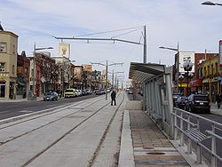
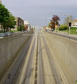
Streetcar Right-of-Way Project
The Toronto Transit Commission decided to upgrade the St. Clair streetcar to a dedicated right-of-way to increase service reliability when the streetcar tracks were approaching the end of their lifespan in the early 2000s. In October 2006, construction started on the right-of-way in the centre of St. Clair. St. Clair Avenue was one of the few streets in Toronto wide enough to accommodate a dedicated right-of-way without significantly reducing the width of traffic lanes.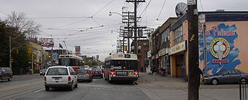
Communities
From west to east, the main section of St. Clair passes through several prominent neighbourhoods starting with Moore ParkMoore Park, Toronto
Moore Park is a neighbourhood in Toronto, Ontario, Canada. It lies along both sides of St. Clair Avenue East between the Vale of Avoca section of Rosedale ravine and Moore Park ravine . The northern boundary is Mount Pleasant Cemetery and the southern the Canadian Pacific Railway tracks.The...
and Deer Park
Deer Park, Toronto
Deer Park is a neighbourhood in Toronto, Ontario, Canada, centred on the intersection of Yonge Street and St. Clair Avenue; its boundaries are the Vale of Avoca section of Rosedale ravine in the east, Farnham Avenue and Jackes Avenue in the south, Avenue Road and Oriole Parkway in the west, the...
. West of Avenue Road are Forest Hill
Forest Hill, Toronto
Forest Hill is an affluent neighbourhood in central Toronto, Ontario, Canada. Along with Lawrence Park, Rosedale, and The Bridle Path, it is one of Toronto’s wealthiest neighbourhoods.-History:...
, Oakwood, Earlscourt
Earlscourt, Toronto
Earlscourt is a neighbourhood in Toronto, Canada. It is centred on St. Clair Avenue West, with Dufferin Street, Davenport Road, and Old Weston Road forming its boundaries....
(including Corso Italia), and The Junction
The Junction
The Junction is a neighbourhood in Toronto, Ontario, Canada, that is near the junction of four railway lines in the area known as the West Toronto Diamond. The neighbourhood was previously an independent city called West Toronto, that was also its own federal electoral district until amalgamating...
. The eastern section of St. Clair passes eastward through Parkview Hill, Woodbine Gardens, Clairlea, Birchmount Park, and Kennedy Park to Cliffcrest.
St. Clair Avenue is well-known for the high population of Portuguese
Portuguese people
The Portuguese are a nation and ethnic group native to the country of Portugal, in the west of the Iberian peninsula of south-west Europe. Their language is Portuguese, and Roman Catholicism is the predominant religion....
, Latin America
Latin America
Latin America is a region of the Americas where Romance languages – particularly Spanish and Portuguese, and variably French – are primarily spoken. Latin America has an area of approximately 21,069,500 km² , almost 3.9% of the Earth's surface or 14.1% of its land surface area...
n and Italian people. St. Clair is usually where the Italian and Portuguese soccer fans celebrate after a game they won. Over the years, the Italian and Portuguese people throughout Toronto
Toronto
Toronto is the provincial capital of Ontario and the largest city in Canada. It is located in Southern Ontario on the northwestern shore of Lake Ontario. A relatively modern city, Toronto's history dates back to the late-18th century, when its land was first purchased by the British monarchy from...
have established a rivalry in soccer against each other. One of the longest lasting celebrations on St. Clair was when Italy
Italy national football team
The Italy National Football Team , represents Italy in association football and is controlled by the Italian Football Federation , the governing body for football in Italy. Italy is the second most successful national team in the history of the World Cup having won four titles , just one fewer than...
won the 2006 FIFA World Cup
2006 FIFA World Cup
The 2006 FIFA World Cup was the 18th FIFA World Cup, the quadrennial international football world championship tournament. It was held from 9 June to 9 July 2006 in Germany, which won the right to host the event in July 2000. Teams representing 198 national football associations from all six...
, which lasted from around 3:30p.m. until around 2:30a.m.
Corso Italia, Toronto's other Italian enclave, is found on St. Clair Avenue West, between Westmount Avenue (just east of Dufferin Street
Dufferin Street
Dufferin Street is a major north-south street in Toronto, Ontario, Canada. It is a concession road, two concessions west of Yonge Street. The street starts at the foot of Lake Ontario, continues north to Toronto's northern boundary with some discontinuities and continues into York Region where it...
) and Lansdowne Avenue
Lansdowne Avenue
Lansdowne Avenue is an arterial road in Toronto, Ontario. It runs north-south and starts at Queen Street West and proceeds north to St. Clair Avenue West. Lansdowne Avenue is primarily a four-lane arterial road, with two lanes regularly used for motor vehicle parking.-Character:Lansdowne Avenue...
. St. Clair West is also used as an umbrella term to refer to all neighbourhoods from Old Weston Road to Bathurst as they share a similar building style. Although the area has been historically referenced as predominantly Italian, it is no longer populated by any one majority. Many new homebuyers looking to purchase in the City are choosing St. Clair West for its relatively modest home prices, the pride of ownership apparent throughout its neighbourhoods, and the new St. Clair Ave. TTC streetcar right-of-way.
St. Clair Avenue holds Toronto's biggest celebration of salsa Latino culture. The two-day street festival attracts an estimate of 250,000-500,000 people, the majority of them being from Latinos living in Toronto and all over Ontario come together to dance, eat, shop and celebrate the culture of Latin America. The festival is always held in July on the week, which it has been traditionally recognized as Latino Week in Toronto, in honour of the festival.
Several funeral homes dotted St. Clair West: McDougall and Brown, A.W. Miles and Jerrett.
Landmarks
- Loring-Wyle Parkette at St. Clair and Mount Pleasant
- Imperial Oil Building
- St. Michael's College SchoolSt. Michael's College SchoolSt. Michael's College School is a private, all-boys Roman Catholic day school in Toronto, Canada. Currently administered by the Basilian Fathers, it is the largest school of its kind in Canada, with an enrollment of approximately 1,080 students from grades 7 to 12. St...
, at St. Clair and Bathurst - Wittington TowerWittington Tower (Toronto)Designed by architect Leslie Rebanks, the Wittington Tower is a 20-storey octagonal tower located at 22 St. Clair Avenue East. It was completed in 1975 and its design received international acclaim and won several design awards. Part of the Weston Centre, the top two floors are occupied by the...
- R. H. King AcademyR. H. King AcademyR. H. King Academy, formerly named R. H. King Collegiate Institute and Scarborough High School, is a secondary school located in the Scarborough district of Toronto, Ontario, Canada and is part of the Toronto District School Board. The school was founded in 1922 as Scarborough High School and...
Churches:
- Deer Park United ChurchDeer Park United ChurchDeer Park United Church began in 1881 as Deer Park Presbyterian Mission, and the first building was constructed on the northwest corner of Yonge Street and St Clair, now presently home of an office tower containing a few radio stations, including CFRB, 99.9 Mix FM and 97.3 EZ Rock. In 1913, a...
- First Unitarian Congregation of TorontoFirst Unitarian Congregation of TorontoThe First Unitarian Congregation of Toronto is a Unitarian Universalist congregation in Toronto, Ontario, Canada. It is affiliated with the Canadian Unitarian Council. It is the largest of six UU congregations and fellowships in the Greater Toronto Area....
- Timothy Eaton Memorial ChurchTimothy Eaton Memorial ChurchTimothy Eaton Memorial Church, in Toronto, Canada, was erected at 230 St. Clair Avenue West in 1914 as a Methodist congregation, and named for department store founder Timothy Eaton....
, at 230 St. Clair Avenue West
In popular culture
"Jane St. Clair", in the Barenaked LadiesBarenaked Ladies
Barenaked Ladies is a Canadian alternative rock band. The band is currently composed of Jim Creeggan, Kevin Hearn, Ed Robertson, and Tyler Stewart. Barenaked Ladies formed in 1988 in Scarborough, Ontario, then a suburban municipality outside the City of Toronto...
' song "Jane", is named for the intersection of Jane Street and St. Clair Avenue.