
Axial Seamount
Encyclopedia
Axial Seamount is a seamount
and submarine volcano
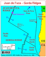
located on the Juan de Fuca Ridge
approximately 480 km (298 mi) west of Cannon Beach, Oregon. The seamount, 1100 m (3,609 ft) high, stands 700 m (2,297 ft) above the average height of the Juan de Fuca Ridge. In 1998 it was selected as the site of NeMO (New Millennium Observatory), an Ocean Bottom Observatory and vent monitoring system.
It received significant scientific attention following the seismic detection of a submarine eruption at the volcano in January 1998. Subsequent cruises in February revealed the lava has erupted from a 9 km (6 mi) long fissure on the south end of Axial's main caldera. Lava flows partially buried a seismometer and pressure gauge and mooring line on the volcano, which had been earlier deployed in 1997. The volcano erupted again in 2011.
, a chain of seamounts
that terminates south of Alaska. Axial lies where the chain intersects with the Juan de Fuca Ridge
, approximately 480 km (298 mi) west of Oregon. It is a product of the Cobb hotspot
, but now sits on an ocean spreading center between the Juan de Fuca Plate
and the North American Plate
, offset by the Blanco Fracture Zone to the south and a ridge-built
triple junction
to the north. This position that is not yet entirely understood.
It is believed that the chain, formed over millions of years by the now-inactive Cobb hotspot, is older than the mid-ocean ridge it bisects. Between 200,000 and 700,000 years ago, the hotspot was encroached by the tectonic spreading center, displacing it by as much as 20 km (12 mi) and building up the 500 km (311 mi) long Juan de Fuca Ridge. At least 7 spreading centers have been recognized, and plate measurements near Axial show that the ridge is separating at a rate of 6 cm (2 in) per year,
Axial Seamount (sometimes Coaxial Seamount or Axial Volcano) is a seamount
and submarine volcano
located on the Juan de Fuca Ridge
approximately 480 km (298 mi) west of Cannon Beach, Oregon. The seamount, 1100 m (3,609 ft) high, stands 700 m (2,297 ft) above the average height of the Juan de Fuca Ridge. In 1998 it was selected as the site of NeMO (New Millennium Observatory), an Ocean Bottom Observatory and vent monitoring system.
It received significant scientific attention following the seismic detection of a submarine eruption at the volcano in January 1998. Subsequent cruises in February revealed the lava has erupted from a 9 km (6 mi) long fissure on the south end of Axial's main caldera. Lava flows partially buried a seismometer and pressure gauge and mooring line on the volcano, which had been earlier deployed in 1997. The volcano erupted again in 2011.
, a chain of seamounts
that terminates south of Alaska. Axial lies where the chain intersects with the Juan de Fuca Ridge
, approximately 480 km (298 mi) west of Oregon. It is a product of the Cobb hotspot
, but now sits on an ocean spreading center between the Juan de Fuca Plate
and the North American Plate
, offset by the Blanco Fracture Zone to the south and a ridge-built
triple junction
to the north. This position that is not yet entirely understood.
It is believed that the chain, formed over millions of years by the now-inactive Cobb hotspot, is older than the mid-ocean ridge it bisects. Between 200,000 and 700,000 years ago, the hotspot was encroached by the tectonic spreading center, displacing it by as much as 20 km (12 mi) and building up the 500 km (311 mi) long Juan de Fuca Ridge. At least 7 spreading centers have been recognized, and plate measurements near Axial show that the ridge is separating at a rate of 6 cm (2 in) per year, producing a complex system of oceanic basin
s and ridge
s. However some scientists have questioned this theory, pointing out that the high density of the chain's seamounts, which often overlap, runs counter to the long trail a hotspot would normally produce. Although the exact nature of Axial Seamount remains unknown, its polysemous origins makes it one of the most geologically interesting features in the North Pacific.
s along the seamount have modeled the ridge's history up to 30 million years ago, and shown that growth has progressed mostly in the north, with some southward progression dating back to 3.5 million years. The base of Axial Seamount is a long, low-lying plateau, and the eastern part of the seamount is defined by a series of linear scarps
. Axial Seamount has two major volcanic rift
s extending approximately 50 km (31 mi) north and south its main summit, as well as several much smaller, ill-defined ones aligned in a roughly similar pattern. Basins around the volcano further its irregularity, making it unusually complex, as most seamounts of roughly the same size are circular or flattened in shape.
Axial Seamount's summit is marked by an unusual rectangular caldera
, 3 by 8 km (1.9 by 5 mi) in area, ~3° in slope, and breached on the southeast side. The area is offset by the two rift zones and defined on three sides by boundary faults up to 150 m (492 ft) deep. The caldera is roughly 50 m (164 ft) deeper at the north side then it is in the south. Flows within the caldera consist mostly of sheet flows pocketed by lava ponds and pit crater
s. Less common are pillow lava
s; their arrangement along the caldera walls suggests that they were an important component in the volcano's early growth. There are several dome
-like structures within the caldera with heights of 100–300 m (328.1–984.3 ft). There are several small crater
s within the region, the largest of which, nicknamed the D.D. Cone, is 2 km (1 mi) in diameter and 100 m (328 ft) in relief. However, most of the features do not range over 30 to 40 m (98.4 to 131.2 ft) deep and 1 km (0.621372736649807 mi) across.
The northern rift zone of Axial Seamount is a 5 km (3 mi) long ridge running 10 to 20 degrees northeast of the main caldera. The rift is pocketed by multiple fissure
s, 100–200 m (328.1–656.2 ft) in length, as far as 7 km (4 mi) from Axial Volcano's center, and reaching up to 400 m (1,312 ft) long and 20 m (66 ft) deep. The area contains high amounts of volcanic glass
; a major eruption is still visible in the form of an elongated glassy lava flow extending off the caldera wall, east of the main rift line. Dives in 1983 found extensive low-temperature venting
at the northern half of the fissure. The shorter, newer southern rift zone consists of a topographically plunging rift, surrounding by subtle, discontinuous faults. Camera tows along the southern flank reveal that the area is built of delineated sheet flows, small lava ponds, and lava channel
s.
The youngest of the flows on Axial Seamount are aligned along the two rift zones, followed by flows inside the summit caldera; the oldest appear to originate from directly around the caldera, where most of the basalt is completely covered in accumulated sediment. This suggests a bilateral growth pattern, a trend also found in Hawaii
an volcanics and other well-known seamounts, for instance Jasper Seamount
.
Axial Seamount's growth has intersected the growth of many of the smaller seamounts around it. The largest of these is Brown Bear Seamount
, to which it is connected by a narrow ridge running roughly perpendicular to its western caldera wall. However, little evidence of interactions between the two seamounts has been found. On the other hand, Axial Seamount's southern rift zone bisects one of the Vance Seamounts
by as much as 30 km (19 mi), creating a zone of intense fissuring at the northern edge of the smaller volcano. Interactions with Cobb Seamount
to the north are more complex, forming an unusual "bent spreading center." In addition there are four smaller structures directly east, north, and south of Axial.
to the south in scientific interest.
The first bathymetry of the seamount was compiled by the NOAAS Surveyor in 1981, as part of SeaBeam trials in the North Pacific. The survey was specifically meant to find and link seafloor hydrothermal activity to geomorphic features. Four areas of increased temperature concentration, indicative of hydrothermal activity were found, and the then-unnamed Axial Seamount was among them. Submersible dives with Pisces IV and DSV Alvin
in 1983 and 1984 discovered the first active black smoker vents in the north Pacific. Soon after Axial Seamount was named for its central position on the intersection of the Cobb-Eickelberg Seamount chain
and Juan de Fuca Ridge. That same year, the National Oceanic and Atmospheric Administration
(NOAA) founded its VENTS program, providing impetus for studying the volcano more closely.
Between 1987 and 1992, a variety of pressure sensors, tilt sensors, temperature probes, and seismometers were dropped dropped on the volcano in what came to be known as the Volcanic Systems Moninters (VSN). Further bathymetries by the NOAAS Discoverer
in 1991 and RV Sonne
in 1996 detailed the seamount further, making it one of the best known features in the North Pacific. Also in 1996, the New Millenium Observatory (NeMO) was established on Axial Seamount, to study volcanic perturbations and the effect they have on hydrothermal communities.
s, common indicators of volcanic activity. The swarms correlated to magma movements in the volcano; bottom pressure recorders deployed on the volcano between 1987 and 1992 recorded five instances of deflation in the summit surface (caused by lava movement), ranging from 3 to 10 cm (1.2 to 3.9 in). In 1991, the National Oceanic and Atmospheric Administration
(NOAA) was granted access to the United States Navy
's SOSUS
system, a chain of submerged hydrophone
s in the North Pacific originally used by the Navy to detect Russian submarine
s during the Cold War
. Since 1993, the NOAA has maintained a real-time monitoring system that alerts the organization whenever an event occurs. The hydrophones are able to detect even very small earthquakes (~ magnitude 1.8) by listening for the acoustic waves generated by T-wave
s. These waves can propagate over large distances with minimal loss in power, making them an ideal way to record otherwise unnoticeable submarine earthquakes; over the course of the eruption, only 3 earthquakes were strong enough to register on land-based systems. However, they cannot interpret earthquake depth or what caused them.
Between 1991 and 1996 Axial Seamount experienced a single earthquake swarm of over 50 events. Between May and November of 1997 this activity increased markedly, with SOSUS recording 5 such swarms, culminating with a massive 11-day, 8247-quake event around the time of the eruption, in January of 1998. The seismicity began at the summit, but within 6 hours had begun to migrate south as well; by 29 November 2010 the swarm had moved south by 50 kilometres (31 mi). This coincided with lava release along the summit and southern flank. The seamount remained absolutely quiet thereafter, suggesting the completion of an eruptive cycle at the volcano. In all, 9055 earthquakes were detected, and 1669 were strong enough to be located. Earthquake activity was concentrated around the summit and southern rift zones, with the majority of events centered inside the summit caldera; temperature probes and pressure recorders in the caldera recorded an average 0.6° C increase and 3.3 m (11 ft) height deflation, respectively, during the event. This close monitoring gives the 1998 eruption the distinction of being the only submarine eruption ever observed in situ
.
The first confirmation of the eruption came in January through February 1998, when lines cast to measure water conditions in the area came up with unusual results. In May, a dedicated bathymetric survey
of the seamount showed topographical changes along the volcano's southern flank, which estimated the thickest flows to 13 m (43 ft). In July DSV Alvin
made several dives on the seamount's summit caldera, followed in August through September by an extensive observation and collection program using ROV
ROPOS
, confirming the bathymetric estimates. A sheet flow more than 3 km (2 mi) long and 500 to 800 m (1,640.4 to 2,624.7 ft) wide was produced from Axial Seamount's upper southern flank, on the site of what was formerly an active geothermal field. The southern flows were in an area marked by a difference between older sediments and newer, glassier rock, and the maximum ridge generated by the eruption, at the crest of the southern flow, was 13 m (42.7 ft) high. The total eruptive volume was roughly 18000–76000 km³ (4,318.4–18,233.4 mi3).
The development, eruption, and close monitoring of Axial Seamount provided a fertile model on submarine volcanic eruptions to scientists; four related papers were published in the August 1998 issue of the Journal of Geophysical Research
.
 Camera tows and sumersible dives in the 1980s and 1990s revealed Axial Seamount as an active venting site with a vibrant range of biologal life, including the only known black smoker in the northwest Pacific.
Seamount
A seamount is a mountain rising from the ocean seafloor that does not reach to the water's surface , and thus is not an island. These are typically formed from extinct volcanoes, that rise abruptly and are usually found rising from a seafloor of depth. They are defined by oceanographers as...
and submarine volcano
Submarine volcano
Submarine volcanoes are underwater fissures in the Earth's surface from which magma can erupt. They are estimated to account for 75% of annual magma output. The vast majority are located near areas of tectonic plate movement, known as ocean ridges...
located on the Juan de Fuca Ridge
Juan de Fuca Ridge
The Juan de Fuca Ridge is a tectonic spreading center located off the coasts of the state of Washington in the United States and the province of British Columbia in Canada. It runs northward from a transform boundary, the Blanco Fracture Zone, to a triple junction with the Nootka Fault and the...
approximately 480 km (298 mi) west of Cannon Beach, Oregon. The seamount, 1100 m (3,609 ft) high, stands 700 m (2,297 ft) above the average height of the Juan de Fuca Ridge. In 1998 it was selected as the site of NeMO (New Millennium Observatory), an Ocean Bottom Observatory and vent monitoring system.
It received significant scientific attention following the seismic detection of a submarine eruption at the volcano in January 1998. Subsequent cruises in February revealed the lava has erupted from a 9 km (6 mi) long fissure on the south end of Axial's main caldera. Lava flows partially buried a seismometer and pressure gauge and mooring line on the volcano, which had been earlier deployed in 1997. The volcano erupted again in 2011.
Tectonic setting
Axial Seamount is the youngest volcano and current eruptive center of the Cobb-Eickelberg Seamount chainCobb-Eickelberg Seamount chain
The Cobb-Eickelberg Seamount chain is a seamount chain stretching from the Aleutian Trench in the north to Axial Seamount, the youngest volcano in the chain, which lies approximately 300 miles west of Cannon Beach, Oregon. The chain was created by the Cobb hotspot as the Pacific Plate drifted in a...
, a chain of seamounts
Seamount
A seamount is a mountain rising from the ocean seafloor that does not reach to the water's surface , and thus is not an island. These are typically formed from extinct volcanoes, that rise abruptly and are usually found rising from a seafloor of depth. They are defined by oceanographers as...
that terminates south of Alaska. Axial lies where the chain intersects with the Juan de Fuca Ridge
Juan de Fuca Ridge
The Juan de Fuca Ridge is a tectonic spreading center located off the coasts of the state of Washington in the United States and the province of British Columbia in Canada. It runs northward from a transform boundary, the Blanco Fracture Zone, to a triple junction with the Nootka Fault and the...
, approximately 480 km (298 mi) west of Oregon. It is a product of the Cobb hotspot
Cobb hotspot
The Cobb hotspot is a volcanic hotspot located off the Oregon/Washington coast of the United States. The hotspot is at the Juan de Fuca Ridge, and has made the Cobb-Eickelberg Seamount chain...
, but now sits on an ocean spreading center between the Juan de Fuca Plate
Juan de Fuca Plate
The Juan de Fuca Plate, named after the explorer of the same name, is a tectonic plate, generated from the Juan de Fuca Ridge, and subducting under the northerly portion of the western side of the North American Plate at the Cascadia subduction zone...
and the North American Plate
North American Plate
The North American Plate is a tectonic plate covering most of North America, Greenland, Cuba, Bahamas, and parts of Siberia, Japan and Iceland. It extends eastward to the Mid-Atlantic Ridge and westward to the Chersky Range in eastern Siberia. The plate includes both continental and oceanic crust...
, offset by the Blanco Fracture Zone to the south and a ridge-built
Mid-ocean ridge
A mid-ocean ridge is a general term for an underwater mountain system that consists of various mountain ranges , typically having a valley known as a rift running along its spine, formed by plate tectonics. This type of oceanic ridge is characteristic of what is known as an oceanic spreading...
triple junction
Triple junction
A triple junction is the point where the boundaries of three tectonic plates meet. At the triple junction a boundary will be one of 3 types - a ridge, trench or transform fault - and triple junctions can be described according to the types of plate margin that meet at them...
to the north. This position that is not yet entirely understood.
It is believed that the chain, formed over millions of years by the now-inactive Cobb hotspot, is older than the mid-ocean ridge it bisects. Between 200,000 and 700,000 years ago, the hotspot was encroached by the tectonic spreading center, displacing it by as much as 20 km (12 mi) and building up the 500 km (311 mi) long Juan de Fuca Ridge. At least 7 spreading centers have been recognized, and plate measurements near Axial show that the ridge is separating at a rate of 6 cm (2 in) per year,
Axial Seamount (sometimes Coaxial Seamount or Axial Volcano) is a seamount
Seamount
A seamount is a mountain rising from the ocean seafloor that does not reach to the water's surface , and thus is not an island. These are typically formed from extinct volcanoes, that rise abruptly and are usually found rising from a seafloor of depth. They are defined by oceanographers as...
and submarine volcano
Submarine volcano
Submarine volcanoes are underwater fissures in the Earth's surface from which magma can erupt. They are estimated to account for 75% of annual magma output. The vast majority are located near areas of tectonic plate movement, known as ocean ridges...
located on the Juan de Fuca Ridge
Juan de Fuca Ridge
The Juan de Fuca Ridge is a tectonic spreading center located off the coasts of the state of Washington in the United States and the province of British Columbia in Canada. It runs northward from a transform boundary, the Blanco Fracture Zone, to a triple junction with the Nootka Fault and the...
approximately 480 km (298 mi) west of Cannon Beach, Oregon. The seamount, 1100 m (3,609 ft) high, stands 700 m (2,297 ft) above the average height of the Juan de Fuca Ridge. In 1998 it was selected as the site of NeMO (New Millennium Observatory), an Ocean Bottom Observatory and vent monitoring system.
It received significant scientific attention following the seismic detection of a submarine eruption at the volcano in January 1998. Subsequent cruises in February revealed the lava has erupted from a 9 km (6 mi) long fissure on the south end of Axial's main caldera. Lava flows partially buried a seismometer and pressure gauge and mooring line on the volcano, which had been earlier deployed in 1997. The volcano erupted again in 2011.
Tectonic setting
Axial Seamount is the youngest volcano and current eruptive center of the Cobb-Eickelberg Seamount chainCobb-Eickelberg Seamount chain
The Cobb-Eickelberg Seamount chain is a seamount chain stretching from the Aleutian Trench in the north to Axial Seamount, the youngest volcano in the chain, which lies approximately 300 miles west of Cannon Beach, Oregon. The chain was created by the Cobb hotspot as the Pacific Plate drifted in a...
, a chain of seamounts
Seamount
A seamount is a mountain rising from the ocean seafloor that does not reach to the water's surface , and thus is not an island. These are typically formed from extinct volcanoes, that rise abruptly and are usually found rising from a seafloor of depth. They are defined by oceanographers as...
that terminates south of Alaska. Axial lies where the chain intersects with the Juan de Fuca Ridge
Juan de Fuca Ridge
The Juan de Fuca Ridge is a tectonic spreading center located off the coasts of the state of Washington in the United States and the province of British Columbia in Canada. It runs northward from a transform boundary, the Blanco Fracture Zone, to a triple junction with the Nootka Fault and the...
, approximately 480 km (298 mi) west of Oregon. It is a product of the Cobb hotspot
Cobb hotspot
The Cobb hotspot is a volcanic hotspot located off the Oregon/Washington coast of the United States. The hotspot is at the Juan de Fuca Ridge, and has made the Cobb-Eickelberg Seamount chain...
, but now sits on an ocean spreading center between the Juan de Fuca Plate
Juan de Fuca Plate
The Juan de Fuca Plate, named after the explorer of the same name, is a tectonic plate, generated from the Juan de Fuca Ridge, and subducting under the northerly portion of the western side of the North American Plate at the Cascadia subduction zone...
and the North American Plate
North American Plate
The North American Plate is a tectonic plate covering most of North America, Greenland, Cuba, Bahamas, and parts of Siberia, Japan and Iceland. It extends eastward to the Mid-Atlantic Ridge and westward to the Chersky Range in eastern Siberia. The plate includes both continental and oceanic crust...
, offset by the Blanco Fracture Zone to the south and a ridge-built
Mid-ocean ridge
A mid-ocean ridge is a general term for an underwater mountain system that consists of various mountain ranges , typically having a valley known as a rift running along its spine, formed by plate tectonics. This type of oceanic ridge is characteristic of what is known as an oceanic spreading...
triple junction
Triple junction
A triple junction is the point where the boundaries of three tectonic plates meet. At the triple junction a boundary will be one of 3 types - a ridge, trench or transform fault - and triple junctions can be described according to the types of plate margin that meet at them...
to the north. This position that is not yet entirely understood.
It is believed that the chain, formed over millions of years by the now-inactive Cobb hotspot, is older than the mid-ocean ridge it bisects. Between 200,000 and 700,000 years ago, the hotspot was encroached by the tectonic spreading center, displacing it by as much as 20 km (12 mi) and building up the 500 km (311 mi) long Juan de Fuca Ridge. At least 7 spreading centers have been recognized, and plate measurements near Axial show that the ridge is separating at a rate of 6 cm (2 in) per year, producing a complex system of oceanic basin
Oceanic basin
Hydrologically, an oceanic basin may be anywhere on Earth that is covered by seawater, but geologically ocean basins are large geologic basins that are below sea level...
s and ridge
Ridge
A ridge is a geological feature consisting of a chain of mountains or hills that form a continuous elevated crest for some distance. Ridges are usually termed hills or mountains as well, depending on size. There are several main types of ridges:...
s. However some scientists have questioned this theory, pointing out that the high density of the chain's seamounts, which often overlap, runs counter to the long trail a hotspot would normally produce. Although the exact nature of Axial Seamount remains unknown, its polysemous origins makes it one of the most geologically interesting features in the North Pacific.
Structure
Axial Seamount is the most active volcanic site in the North Pacific. Study of magnetic delineationGeomagnetic reversal
A geomagnetic reversal is a change in the Earth's magnetic field such that the positions of magnetic north and magnetic south are interchanged. The Earth's field has alternated between periods of normal polarity, in which the direction of the field was the same as the present direction, and reverse...
s along the seamount have modeled the ridge's history up to 30 million years ago, and shown that growth has progressed mostly in the north, with some southward progression dating back to 3.5 million years. The base of Axial Seamount is a long, low-lying plateau, and the eastern part of the seamount is defined by a series of linear scarps
Fault scarp
A fault scarp is the topographic expression of faulting attributed to the displacement of the land surface by movement along faults. They are exhibited either by differential movement and subsequent erosion along an old inactive geologic fault , or by a movement on a recent active fault...
. Axial Seamount has two major volcanic rift
Rift zone
A rift zone is a feature of some volcanoes, especially the shield volcanoes of Hawaii, in which a linear series of fissures in the volcanic edifice allows lava to be erupted from the volcano's flank instead of from its summit...
s extending approximately 50 km (31 mi) north and south its main summit, as well as several much smaller, ill-defined ones aligned in a roughly similar pattern. Basins around the volcano further its irregularity, making it unusually complex, as most seamounts of roughly the same size are circular or flattened in shape.
Axial Seamount's summit is marked by an unusual rectangular caldera
Caldera
A caldera is a cauldron-like volcanic feature usually formed by the collapse of land following a volcanic eruption, such as the one at Yellowstone National Park in the US. They are sometimes confused with volcanic craters...
, 3 by 8 km (1.9 by 5 mi) in area, ~3° in slope, and breached on the southeast side. The area is offset by the two rift zones and defined on three sides by boundary faults up to 150 m (492 ft) deep. The caldera is roughly 50 m (164 ft) deeper at the north side then it is in the south. Flows within the caldera consist mostly of sheet flows pocketed by lava ponds and pit crater
Pit crater
A pit crater is a depression formed by a sinking of the ground surface lying above a void or empty chamber, rather than by the eruption of a volcano or lava vent. It is often found in chains or troughs. Several craters may merge into a linear alignment...
s. Less common are pillow lava
Pillow lava
Pillow lavas are lavas that contain characteristic pillow-shaped structures that are attributed to the extrusion of the lava under water, or subaqueous extrusion. Pillow lavas in volcanic rock are characterized by thick sequences of discontinuous pillow-shaped masses, commonly up to one metre in...
s; their arrangement along the caldera walls suggests that they were an important component in the volcano's early growth. There are several dome
Lava dome
|250px|thumb|right|Image of the [[rhyolitic]] lava dome of [[Chaitén Volcano]] during its 2008–2009 eruption.In volcanology, a lava dome is a roughly circular mound-shaped protrusion resulting from the slow extrusion of viscous lava from a volcano...
-like structures within the caldera with heights of 100–300 m (328.1–984.3 ft). There are several small crater
Volcanic crater
A volcanic crater is a circular depression in the ground caused by volcanic activity. It is typically a basin, circular in form within which occurs a vent from which magma erupts as gases, lava, and ejecta. A crater can be of large dimensions, and sometimes of great depth...
s within the region, the largest of which, nicknamed the D.D. Cone, is 2 km (1 mi) in diameter and 100 m (328 ft) in relief. However, most of the features do not range over 30 to 40 m (98.4 to 131.2 ft) deep and 1 km (0.621372736649807 mi) across.
The northern rift zone of Axial Seamount is a 5 km (3 mi) long ridge running 10 to 20 degrees northeast of the main caldera. The rift is pocketed by multiple fissure
Fissure
In anatomy, a fissure is a groove, natural division, deep furrow, elongated cleft, or tear in various parts of the body.-Brain:...
s, 100–200 m (328.1–656.2 ft) in length, as far as 7 km (4 mi) from Axial Volcano's center, and reaching up to 400 m (1,312 ft) long and 20 m (66 ft) deep. The area contains high amounts of volcanic glass
Volcanic glass
Volcanic glass is the amorphous product of rapidly cooling magma. Like all types of glass, it is a state of matter intermediate between the close-packed, highly ordered array of a crystal and the highly disordered array of gas...
; a major eruption is still visible in the form of an elongated glassy lava flow extending off the caldera wall, east of the main rift line. Dives in 1983 found extensive low-temperature venting
Hydrothermal vent
A hydrothermal vent is a fissure in a planet's surface from which geothermally heated water issues. Hydrothermal vents are commonly found near volcanically active places, areas where tectonic plates are moving apart, ocean basins, and hotspots. Hydrothermal vents exist because the earth is both...
at the northern half of the fissure. The shorter, newer southern rift zone consists of a topographically plunging rift, surrounding by subtle, discontinuous faults. Camera tows along the southern flank reveal that the area is built of delineated sheet flows, small lava ponds, and lava channel
Lava channel
A lava channel is a stream of fluid lava contained within marginal zones of static lava or levees. The initial channel may not contain levees per se, until the parental flow solidifies over what develops into the channel and creates simple levees. This initial levee allows for the building of a...
s.
The youngest of the flows on Axial Seamount are aligned along the two rift zones, followed by flows inside the summit caldera; the oldest appear to originate from directly around the caldera, where most of the basalt is completely covered in accumulated sediment. This suggests a bilateral growth pattern, a trend also found in Hawaii
Hawaii hotspot
The Hawaii hotspot is the volcanic hotspot that created the Hawaiian Islands in the central Pacific Ocean, and is one of Earth's best-known and most heavily-studied hotspots....
an volcanics and other well-known seamounts, for instance Jasper Seamount
Jasper Seamount
Jasper Seamount is a seamount located in the Fieberling-Guadalupe seamount track, west of Baja California, Mexico. Jasper is the site of detailed geophysical geological and geochemical studies which suggest that many seamounts, big and small, follow the same pattern of growth and death that was...
.
Axial Seamount's growth has intersected the growth of many of the smaller seamounts around it. The largest of these is Brown Bear Seamount
Brown Bear Seamount
Brown Bear Seamount is a seamount approximately west of the coast of Oregon. It is connected to the larger Axial Seamount by a small ridge. Brown Bear Seamount was created by the Cobb hotspot, and is located on the near west of the Juan de Fuca Ridge...
, to which it is connected by a narrow ridge running roughly perpendicular to its western caldera wall. However, little evidence of interactions between the two seamounts has been found. On the other hand, Axial Seamount's southern rift zone bisects one of the Vance Seamounts
Vance Seamounts
The Vance Seamounts are a group of seven submarine volcanoes located west of the Juan de Fuca Ridge. Most of the seamounts contain a caldera. They are the southernmost of several near-ridge chains located on the Pacific Plate, stemming from the Juan de Fuca Ridge.The easternmost five of the seven...
by as much as 30 km (19 mi), creating a zone of intense fissuring at the northern edge of the smaller volcano. Interactions with Cobb Seamount
Cobb Seamount
Cobb Seamount is a seamount and guyot located west of Gray's Harbor, Washington, United States. Cobb Seamount is one of the seamounts in the Cobb-Eickelberg Seamount chain, a chain of underwater volcanoes created by the Cobb hotspot that terminates near the coast of Alaska. It is aligned along...
to the north are more complex, forming an unusual "bent spreading center." In addition there are four smaller structures directly east, north, and south of Axial.
History
The first volcanoes along the Juan de Fuca ridge, including Axial Seamount, were detected in the 1970s by satellite altimetry. Axial Seamount's proximity to the western coast and shallow depth make it one of the most easily accessible seamounts in the world, and its unique geological setting and active state also makes it one of the most interesting, rivaling Davidson SeamountDavidson Seamount
Davidson Seamount is a seamount located off the coast of Central California, southwest of Monterey and west of San Simeon. At long and wide, it is one of the largest known seamounts in the world. From base to crest, the seamount is tall, yet its summit is still below the sea surface...
to the south in scientific interest.
The first bathymetry of the seamount was compiled by the NOAAS Surveyor in 1981, as part of SeaBeam trials in the North Pacific. The survey was specifically meant to find and link seafloor hydrothermal activity to geomorphic features. Four areas of increased temperature concentration, indicative of hydrothermal activity were found, and the then-unnamed Axial Seamount was among them. Submersible dives with Pisces IV and DSV Alvin
DSV Alvin
Alvin is a manned deep-ocean research submersible owned by the United States Navy and operated by the Woods Hole Oceanographic Institution in Woods Hole, Massachusetts. The vehicle was built by General Mills' Electronics Group in the same factory used to manufacture breakfast cereal-producing...
in 1983 and 1984 discovered the first active black smoker vents in the north Pacific. Soon after Axial Seamount was named for its central position on the intersection of the Cobb-Eickelberg Seamount chain
Cobb-Eickelberg Seamount chain
The Cobb-Eickelberg Seamount chain is a seamount chain stretching from the Aleutian Trench in the north to Axial Seamount, the youngest volcano in the chain, which lies approximately 300 miles west of Cannon Beach, Oregon. The chain was created by the Cobb hotspot as the Pacific Plate drifted in a...
and Juan de Fuca Ridge. That same year, the National Oceanic and Atmospheric Administration
National Oceanic and Atmospheric Administration
The National Oceanic and Atmospheric Administration , pronounced , like "noah", is a scientific agency within the United States Department of Commerce focused on the conditions of the oceans and the atmosphere...
(NOAA) founded its VENTS program, providing impetus for studying the volcano more closely.
Between 1987 and 1992, a variety of pressure sensors, tilt sensors, temperature probes, and seismometers were dropped dropped on the volcano in what came to be known as the Volcanic Systems Moninters (VSN). Further bathymetries by the NOAAS Discoverer
NOAAS Discoverer (R 102)
NOAAS Discoverer , originally USC&GS Discoverer, was an American Oceanographer-class oceanographic research vessel in service in the United States Coast and Geodetic Survey from 1966 to 1970 and in the National Oceanic and Atmospheric Administration from 1970 to 1996.-Construction:Discoverer was...
in 1991 and RV Sonne
RV Sonne
The RV Sonne is a former fishing trawler converted into a research vessel, doing mostly geoscience-related work for a variety of commercial and scientific clients. She is registered in Bremen.- Career :...
in 1996 detailed the seamount further, making it one of the best known features in the North Pacific. Also in 1996, the New Millenium Observatory (NeMO) was established on Axial Seamount, to study volcanic perturbations and the effect they have on hydrothermal communities.
1998 eruption
The 1998 eruption of Axial Seamount was preceded by several large earthquake swarmEarthquake swarm
Earthquake swarms are events where a local area experiences sequences of many earthquakes striking in a relatively short period of time. The length of time used to define the swarm itself varies, but the United States Geological Survey points out that an event may be on the order of days, weeks, or...
s, common indicators of volcanic activity. The swarms correlated to magma movements in the volcano; bottom pressure recorders deployed on the volcano between 1987 and 1992 recorded five instances of deflation in the summit surface (caused by lava movement), ranging from 3 to 10 cm (1.2 to 3.9 in). In 1991, the National Oceanic and Atmospheric Administration
National Oceanic and Atmospheric Administration
The National Oceanic and Atmospheric Administration , pronounced , like "noah", is a scientific agency within the United States Department of Commerce focused on the conditions of the oceans and the atmosphere...
(NOAA) was granted access to the United States Navy
United States Navy
The United States Navy is the naval warfare service branch of the United States Armed Forces and one of the seven uniformed services of the United States. The U.S. Navy is the largest in the world; its battle fleet tonnage is greater than that of the next 13 largest navies combined. The U.S...
's SOSUS
SOSUS
SOSUS, an acronym for Sound Surveillance System, is a chain of underwater listening posts across the northern Atlantic Ocean near Greenland, Iceland and the United Kingdom — the GIUK gap. It was originally operated by the United States Navy for tracking Soviet submarines, which had to pass...
system, a chain of submerged hydrophone
Hydrophone
A hydrophone is a microphone designed to be used underwater for recording or listening to underwater sound. Most hydrophones are based on a piezoelectric transducer that generates electricity when subjected to a pressure change...
s in the North Pacific originally used by the Navy to detect Russian submarine
Submarine
A submarine is a watercraft capable of independent operation below the surface of the water. It differs from a submersible, which has more limited underwater capability...
s during the Cold War
Cold War
The Cold War was the continuing state from roughly 1946 to 1991 of political conflict, military tension, proxy wars, and economic competition between the Communist World—primarily the Soviet Union and its satellite states and allies—and the powers of the Western world, primarily the United States...
. Since 1993, the NOAA has maintained a real-time monitoring system that alerts the organization whenever an event occurs. The hydrophones are able to detect even very small earthquakes (~ magnitude 1.8) by listening for the acoustic waves generated by T-wave
T-wave
The term T-wave may refer to:In medicine: T wave, a portion of the recording of a heartbeat in an electrocardiogramIn physics::Terahertz radiation, electromagnetic radiation in the microwave band....
s. These waves can propagate over large distances with minimal loss in power, making them an ideal way to record otherwise unnoticeable submarine earthquakes; over the course of the eruption, only 3 earthquakes were strong enough to register on land-based systems. However, they cannot interpret earthquake depth or what caused them.
Between 1991 and 1996 Axial Seamount experienced a single earthquake swarm of over 50 events. Between May and November of 1997 this activity increased markedly, with SOSUS recording 5 such swarms, culminating with a massive 11-day, 8247-quake event around the time of the eruption, in January of 1998. The seismicity began at the summit, but within 6 hours had begun to migrate south as well; by 29 November 2010 the swarm had moved south by 50 kilometres (31 mi). This coincided with lava release along the summit and southern flank. The seamount remained absolutely quiet thereafter, suggesting the completion of an eruptive cycle at the volcano. In all, 9055 earthquakes were detected, and 1669 were strong enough to be located. Earthquake activity was concentrated around the summit and southern rift zones, with the majority of events centered inside the summit caldera; temperature probes and pressure recorders in the caldera recorded an average 0.6° C increase and 3.3 m (11 ft) height deflation, respectively, during the event. This close monitoring gives the 1998 eruption the distinction of being the only submarine eruption ever observed in situ
In situ
In situ is a Latin phrase which translated literally as 'In position'. It is used in many different contexts.-Aerospace:In the aerospace industry, equipment on board aircraft must be tested in situ, or in place, to confirm everything functions properly as a system. Individually, each piece may...
.
The first confirmation of the eruption came in January through February 1998, when lines cast to measure water conditions in the area came up with unusual results. In May, a dedicated bathymetric survey
Bathymetry
Bathymetry is the study of underwater depth of lake or ocean floors. In other words, bathymetry is the underwater equivalent to hypsometry. The name comes from Greek βαθύς , "deep", and μέτρον , "measure"...
of the seamount showed topographical changes along the volcano's southern flank, which estimated the thickest flows to 13 m (43 ft). In July DSV Alvin
DSV Alvin
Alvin is a manned deep-ocean research submersible owned by the United States Navy and operated by the Woods Hole Oceanographic Institution in Woods Hole, Massachusetts. The vehicle was built by General Mills' Electronics Group in the same factory used to manufacture breakfast cereal-producing...
made several dives on the seamount's summit caldera, followed in August through September by an extensive observation and collection program using ROV
Remotely operated vehicle
A remotely operated vehicle is a tethered underwater vehicle. They are common in deepwater industries such as offshore hydrocarbon extraction. An ROV may sometimes be called a remotely operated underwater vehicle to distinguish it from remote control vehicles operating on land or in the air. ROVs...
ROPOS
ROPOS
ROPOS is an ROV used primarily for scientific research. It was originally build in Vancouver by International Submarine Engineering and purchased by the Canadian federal government. This government program also operated the Pisces IV manned submersible...
, confirming the bathymetric estimates. A sheet flow more than 3 km (2 mi) long and 500 to 800 m (1,640.4 to 2,624.7 ft) wide was produced from Axial Seamount's upper southern flank, on the site of what was formerly an active geothermal field. The southern flows were in an area marked by a difference between older sediments and newer, glassier rock, and the maximum ridge generated by the eruption, at the crest of the southern flow, was 13 m (42.7 ft) high. The total eruptive volume was roughly 18000–76000 km³ (4,318.4–18,233.4 mi3).
The development, eruption, and close monitoring of Axial Seamount provided a fertile model on submarine volcanic eruptions to scientists; four related papers were published in the August 1998 issue of the Journal of Geophysical Research
Journal of Geophysical Research
The Journal of Geophysical Research is a peer-reviewed scientific journal published by the American Geophysical Union 80 times per year. It contains original research on the physical, chemical, and biological processes that contribute to the understanding of the Earth, Sun, and solar system...
.
2011 eruptions
Axial Seamount erupted again in April 2011, fulfilling a coarse prediction made five years earlier. The eruption prediction was made by Bill Chadwick, an Oregon State University geologist, and Scott Nooner, a geophysicist at Columbia University's Lamont-Doherty Earth Observatory in a paper they published in the Journal of Volcanology and Geothermal Research.Ecology