Upper New York Bay
Encyclopedia


Port of New York and New Jersey
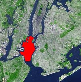
The Port of New York and New Jersey comprises the waterways in the estuary of the New York-Newark metropolitan area with a port district encompassing an approximate area within a radius of the Statue of Liberty National Monument...
, and often called New York Harbor. It is enclosed by the New York City
New York City
New York is the most populous city in the United States and the center of the New York Metropolitan Area, one of the most populous metropolitan areas in the world. New York exerts a significant impact upon global commerce, finance, media, art, fashion, research, technology, education, and...
boroughs of Manhattan
Manhattan
Manhattan is the oldest and the most densely populated of the five boroughs of New York City. Located primarily on the island of Manhattan at the mouth of the Hudson River, the boundaries of the borough are identical to those of New York County, an original county of the state of New York...
, Brooklyn
Brooklyn
Brooklyn is the most populous of New York City's five boroughs, with nearly 2.6 million residents, and the second-largest in area. Since 1896, Brooklyn has had the same boundaries as Kings County, which is now the most populous county in New York State and the second-most densely populated...
, and Staten Island
Staten Island
Staten Island is a borough of New York City, New York, United States, located in the southwest part of the city. Staten Island is separated from New Jersey by the Arthur Kill and the Kill Van Kull, and from the rest of New York by New York Bay...
and the Hudson County, New Jersey
Hudson County, New Jersey
Hudson County is the smallest county in New Jersey and one of the most densely populated in United States. It takes its name from the Hudson River, which creates part of its eastern border. Part of the New York metropolitan area, its county seat and largest city is Jersey City.- Municipalities...
municipalities of Jersey City and Bayonne
Bayonne, New Jersey
Bayonne is a city in Hudson County, New Jersey, United States. Located in the Gateway Region, Bayonne is a peninsula that is situated between Newark Bay to the west, the Kill van Kull to the south, and New York Bay to the east...
.
It is fed by the waters of the Hudson River
Hudson River
The Hudson is a river that flows from north to south through eastern New York. The highest official source is at Lake Tear of the Clouds, on the slopes of Mount Marcy in the Adirondack Mountains. The river itself officially begins in Henderson Lake in Newcomb, New York...
(historically called the North River
North River (New York-New Jersey)
North River is an alternate name for the southernmost portion of the Hudson River in the vicinity of New York City and northeastern New Jersey. The colonial name for the entire Hudson given to it by the Dutch in the early seventeenth century, the term fell out of general use for most of the river's...
as it passes Manhattan
Manhattan
Manhattan is the oldest and the most densely populated of the five boroughs of New York City. Located primarily on the island of Manhattan at the mouth of the Hudson River, the boundaries of the borough are identical to those of New York County, an original county of the state of New York...
), as well as the Gowanus Canal
Gowanus Canal
The Gowanus Canal, also known as the Gowanus Creek Canal, is a canal in the New York City borough of Brooklyn, geographically on the westernmost portion of Long Island...
. It is connected to Lower New York Bay
Lower New York Bay
Lower New York Bay is that section of New York Bay south of the Narrows, the relatively narrow strait between the shores of Staten Island and Brooklyn. The southern end of the bay opens directly to the Atlantic Ocean between two spits of land, Sandy Hook, New Jersey, and Rockaway, Queens, on Long...
by the Narrows, to Newark Bay
Newark Bay
Newark Bay is a tidal bay at the confluence of the Passaic and Hackensack Rivers in northeastern New Jersey. It is home to the Port Newark-Elizabeth Marine Terminal, the largest container shipping facility in Port of New York and New Jersey, 3rd largest and one of busiest in the United States...
by the Kill Van Kull
Kill Van Kull
The Kill Van Kull is a tidal strait between Staten Island, New York and Bayonne, New Jersey in the United States. Approximately long and wide, it connects Newark Bay with Upper New York Bay. The Robbins Reef Light marks the eastern end of the Kill, Bergen Point its western end...
, and to Long Island Sound
Long Island Sound
Long Island Sound is an estuary of the Atlantic Ocean, located in the United States between Connecticut to the north and Long Island, New York to the south. The mouth of the Connecticut River at Old Saybrook, Connecticut, empties into the sound. On its western end the sound is bounded by the Bronx...
by the East River
East River
The East River is a tidal strait in New York City. It connects Upper New York Bay on its south end to Long Island Sound on its north end. It separates Long Island from the island of Manhattan and the Bronx on the North American mainland...
, which despite the name, is actually a tidal strait
Strait
A strait or straits is a narrow, typically navigable channel of water that connects two larger, navigable bodies of water. It most commonly refers to a channel of water that lies between two land masses, but it may also refer to a navigable channel through a body of water that is otherwise not...
. It provides the main passage for the waters of the Hudson River as it empties through the Narrows
The Narrows
The Narrows is the tidal strait separating the boroughs of Staten Island and Brooklyn in New York City. It connects the Upper New York Bay and Lower New York Bay and forms the principal channel by which the Hudson River empties into the Atlantic Ocean...
. The channel of the Hudson as it passes through the harbor is called the Anchorage Channel and is approximately 50 feet deep in the mid point of the harbor.
It contains several islands including Governors Island
Governors Island
Governors Island is a island in Upper New York Bay, approximately one-half mile from the southern tip of Manhattan Island and separated from Brooklyn by Buttermilk Channel. It is legally part of the borough of Manhattan in New York City...
, near the mouth of the East River, as well Ellis Island
Ellis Island
Ellis Island in New York Harbor was the gateway for millions of immigrants to the United States. It was the nation's busiest immigrant inspection station from 1892 until 1954. The island was greatly expanded with landfill between 1892 and 1934. Before that, the much smaller original island was the...
, Liberty Island
Liberty Island
Liberty Island is a small uninhabited island in New York Harbor in the United States, best known as the location of the Statue of Liberty. Though so called since the turn of the century, the name did not become official until 1956. In 1937, by proclamation 2250, President Franklin D...
, and Robbins Reef which are supported by a large underwater reef on the New Jersey
New Jersey
New Jersey is a state in the Northeastern and Middle Atlantic regions of the United States. , its population was 8,791,894. It is bordered on the north and east by the state of New York, on the southeast and south by the Atlantic Ocean, on the west by Pennsylvania and on the southwest by Delaware...
side of the harbor. The reef was historically one of the largest oyster
Oyster
The word oyster is used as a common name for a number of distinct groups of bivalve molluscs which live in marine or brackish habitats. The valves are highly calcified....
beds in the world and provided a staple for the diet of all classes of citizens both locally and regionaly until the end of the 19th century, when the beds succumbed to pollution.
Historically it has played an extremely important role in the commerce of the New York metropolitan area
New York metropolitan area
The New York metropolitan area, also known as Greater New York, or the Tri-State area, is the region that composes of New York City and the surrounding region...
. The Statue of Liberty National Monument recalls the immigrant experience during the late 19th and early 20th century.
Since the 1950s, container ship
Container ship
Container ships are cargo ships that carry all of their load in truck-size intermodal containers, in a technique called containerization. They form a common means of commercial intermodal freight transport.-History:...
traffic has been primarily routed through the Kill Van Kull to Port Newark-Elizabeth Marine Terminal
Port Newark-Elizabeth Marine Terminal
Port Newark-Elizabeth Marine Terminal is a major component of the Port of New York and New Jersey. Located on the Newark Bay it serves as the principal container ship facility for goods entering and leaving New York-Newark metropolitan area, and the northeastern quadrant of North America...
, where it is consolidated for easier automated transfer to land conveyance. As a consequence, the waterfront industries of the Upper Bay experienced a decline leading to diverse plans for revitalization, though important martime uses remain at Red Hook, Brooklyn
Red Hook, Brooklyn
Red Hook is a neighborhood in the New York City borough of Brooklyn, USA. The neighborhood is part of Brooklyn Community Board 6. It is also the location where the transatlantic liner, the , docks in New York City.- History :...
, Port Jersey
Port Jersey
Port Jersey is an intermodal freight transport facility that includes a container terminal located on the Upper New York Bay in the Port of New York and New Jersey. The municipal border of the Hudson County, New Jersey cities of Jersey City and Bayonne runs along the long pier extending into the bay...
, MOTBY, Constable Hook, and parts of the Staten Island shore. Liberty State Park
Liberty State Park
Liberty State Park is located on Upper New York Bay in Jersey City, New Jersey, opposite the Statue of Liberty and Ellis Island. The park opened in 1976 to coincide with bicentennial celebrations and is operated and maintained by the New Jersey Division of Parks and Forestry.-Geography and...
opened in 1976. In recent years, it has become a popular site for recreation sailing and kayak
Kayak
A kayak is a small, relatively narrow, human-powered boat primarily designed to be manually propelled by means of a double blade paddle.The traditional kayak has a covered deck and one or more cockpits, each seating one paddler...
ing.
The harbor is traversed by the Staten Island Ferry
Staten Island Ferry
The Staten Island Ferry is a passenger ferry service operated by the New York City Department of Transportation that runs between the boroughs of Manhattan and Staten Island.-Overview:...
, which runs between Whitehall Street at the southernmost tip of Manhattan
Manhattan
Manhattan is the oldest and the most densely populated of the five boroughs of New York City. Located primarily on the island of Manhattan at the mouth of the Hudson River, the boundaries of the borough are identical to those of New York County, an original county of the state of New York...
near Battery Park (South Ferry
South Ferry (Manhattan)
South Ferry is at the southern tip of Manhattan Island in New York City and is the embarkation point for ferries to Staten Island and Governors Island....
) and St. George Ferry Terminal on Richmond Terrace in Staten Island
Staten Island
Staten Island is a borough of New York City, New York, United States, located in the southwest part of the city. Staten Island is separated from New Jersey by the Arthur Kill and the Kill Van Kull, and from the rest of New York by New York Bay...
near Richmond County Borough Hall and Richmond County Supreme Court. NY Waterway
NY Waterway
NY Waterway, or New York Waterway, is a private transportation company running ferry and bus service in the Port of New York and New Jersey and in the Hudson Valley...
operates routes across the bay and through The Narrows
The Narrows
The Narrows is the tidal strait separating the boroughs of Staten Island and Brooklyn in New York City. It connects the Upper New York Bay and Lower New York Bay and forms the principal channel by which the Hudson River empties into the Atlantic Ocean...
to locations near Sandy Hook
Sandy Hook
Sandy Hook is a barrier spit along the Atlantic coast of New JerseySandy Hook may also refer to:-Places:United States* Sandy Hook , a village in the town of Newtown, Connecticut* Sandy Hook, Kentucky, a city in Elliott County...
.
The Upper Bay supports a very diverse population of marine species, allowing for recreational fishing, most commonly for striped bass and bluefish.
See also

- Brooklyn Cruise TerminalBrooklyn Cruise TerminalThe Brooklyn Cruise Terminal is one of three terminals for ocean-going cruise ships in the metropolitan New York City area. The terminal is located at Red Hook Pier 12, which forms the south side of the Atlantic Basin at Pioneer and Imlay Streets in the Red Hook section of Brooklyn, New York. The...
- Port JerseyPort JerseyPort Jersey is an intermodal freight transport facility that includes a container terminal located on the Upper New York Bay in the Port of New York and New Jersey. The municipal border of the Hudson County, New Jersey cities of Jersey City and Bayonne runs along the long pier extending into the bay...
- MOTBY
- Geography of New York HarborGeography of New York HarborThe system of waterways of the Port of New York and New Jersey forms one of the most intricate natural harbors in the world, a fact that is reflected in the diversity of place names...
- Cross-Harbor Rail TunnelCross-Harbor Rail TunnelThe Cross-Harbor Rail Tunnel is a proposed freight rail transport tunnel under Upper New York Bay in the Port of New York and New Jersey between northeastern New Jersey and Long Island, including southern and eastern New York City.-Background:Direct connections for rail freight between Long Island...
- Liberty State ParkLiberty State ParkLiberty State Park is located on Upper New York Bay in Jersey City, New Jersey, opposite the Statue of Liberty and Ellis Island. The park opened in 1976 to coincide with bicentennial celebrations and is operated and maintained by the New Jersey Division of Parks and Forestry.-Geography and...
- Red Hook (Brooklyn)
- Liberty IslandLiberty IslandLiberty Island is a small uninhabited island in New York Harbor in the United States, best known as the location of the Statue of Liberty. Though so called since the turn of the century, the name did not become official until 1956. In 1937, by proclamation 2250, President Franklin D...
- Ellis IslandEllis IslandEllis Island in New York Harbor was the gateway for millions of immigrants to the United States. It was the nation's busiest immigrant inspection station from 1892 until 1954. The island was greatly expanded with landfill between 1892 and 1934. Before that, the much smaller original island was the...
- Communipaw TerminalCommunipaw TerminalCentral Railroad of New Jersey Terminal, sometimes known as Communipaw Terminal was the Central Railroad of New Jersey's waterfront passenger terminal at the mouth of the Hudson River at the Upper New York Bay in Jersey City, New Jersey.-Designation:...
- Castle ClintonCastle ClintonCastle Clinton or Fort Clinton, once known as Castle Garden, is a circular sandstone fort now located in Battery Park at the southern tip of Manhattan Island, New York City, in the United States. It is perhaps best remembered as America's first immigration station , where more than 8 million...
- Black Tom
- New York HarborNew York HarborNew York Harbor refers to the waterways of the estuary near the mouth of the Hudson River that empty into New York Bay. It is one of the largest natural harbors in the world. Although the U.S. Board of Geographic Names does not use the term, New York Harbor has important historical, governmental,...
- New York BayNew York BayNew York Bay is the collective term for the marine areas surrounding the entrance of the Hudson River into the Atlantic Ocean. Its two largest components are Upper New York Bay and Lower New York Bay, which are connected by The Narrows...

