
Lower New York Bay
Encyclopedia

New York Bay
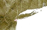
New York Bay is the collective term for the marine areas surrounding the entrance of the Hudson River into the Atlantic Ocean. Its two largest components are Upper New York Bay and Lower New York Bay, which are connected by The Narrows...
south of the Narrows
The Narrows
The Narrows is the tidal strait separating the boroughs of Staten Island and Brooklyn in New York City. It connects the Upper New York Bay and Lower New York Bay and forms the principal channel by which the Hudson River empties into the Atlantic Ocean...
, the relatively narrow strait between the shores of Staten Island
Staten Island
Staten Island is a borough of New York City, New York, United States, located in the southwest part of the city. Staten Island is separated from New Jersey by the Arthur Kill and the Kill Van Kull, and from the rest of New York by New York Bay...
and Brooklyn
Brooklyn
Brooklyn is the most populous of New York City's five boroughs, with nearly 2.6 million residents, and the second-largest in area. Since 1896, Brooklyn has had the same boundaries as Kings County, which is now the most populous county in New York State and the second-most densely populated...
. The southern end of the bay opens directly to the Atlantic Ocean
Atlantic Ocean
The Atlantic Ocean is the second-largest of the world's oceanic divisions. With a total area of about , it covers approximately 20% of the Earth's surface and about 26% of its water surface area...
between two spits of land, Sandy Hook, New Jersey
Sandy Hook, New Jersey
Sandy Hook is a barrier spit, approximately 6.0 miles in length and varying between 0.10 and 1 miles wide in Middletown Township in Monmouth County, along the Atlantic Ocean coast of eastern New Jersey in the United States. The barrier spit encloses the southern entrance of Lower New York Bay...
, and Rockaway, Queens
Rockaway, Queens
The Rockaway Peninsula, informally The Rockaways, is the name of a peninsula of Long Island, all of which is located within the New York City borough of Queens. A popular summer resort area since the 1830s, Rockaway has become a mixture of lower, middle, and upper-class neighborhoods...
, on Long Island
Long Island
Long Island is an island located in the southeast part of the U.S. state of New York, just east of Manhattan. Stretching northeast into the Atlantic Ocean, Long Island contains four counties, two of which are boroughs of New York City , and two of which are mainly suburban...
. The southern portion between Staten Island and New Jersey
New Jersey
New Jersey is a state in the Northeastern and Middle Atlantic regions of the United States. , its population was 8,791,894. It is bordered on the north and east by the state of New York, on the southeast and south by the Atlantic Ocean, on the west by Pennsylvania and on the southwest by Delaware...
, at the mouth of the Raritan River
Raritan River
The Raritan River is a major river of central New Jersey in the United States. Its watershed drains much of the mountainous area of the central part of the state, emptying into the Raritan Bay on the Atlantic Ocean.-Description:...
, is named Raritan Bay
Raritan Bay
Raritan Bay is a bay located at the southern portion of Lower New York Bay between the U.S. states of New York and New Jersey and is part of the New York Bight. The bay is bounded on the northwest by New York's Staten Island, on the west by Perth Amboy, New Jersey, on the south by the Raritan...
. The Hudson Canyon
Hudson Canyon
__notoc__The Hudson Canyon is a submarine canyon that begins from the shallow outlet of the estuary at the mouth of the Hudson River. It extends out over seaward across the continental shelf finally connecting to the deep ocean basin at a depth of 3 to 4 km below sea level...
, the ancient riverbed of the Hudson River
Hudson River
The Hudson is a river that flows from north to south through eastern New York. The highest official source is at Lake Tear of the Clouds, on the slopes of Mount Marcy in the Adirondack Mountains. The river itself officially begins in Henderson Lake in Newcomb, New York...
which existed during the last ice age when the ocean levels were lower, extends southeast from Lower New York Bay for hundreds of miles into the Atlantic Ocean. The nearby part of the Atlantic Ocean between New Jersey and Long Island is the New York Bight
New York Bight
The New York Bight is a slight indentation along the Atlantic coast of the United States, extending northeasterly from Cape May Inlet in New Jersey to Montauk Point on the eastern tip of Long Island...
.
History and geography
Since before the time of the LenapeLenape
The Lenape are an Algonquian group of Native Americans of the Northeastern Woodlands. They are also called Delaware Indians. As a result of the American Revolutionary War and later Indian removals from the eastern United States, today the main groups live in Canada, where they are enrolled in the...
, the Native American inhabitants of the area, the Lower Bay has sustained a rich marine ecosystem
Marine ecosystem
Marine ecosystems are among the largest of Earth's aquatic ecosystems. They include oceans, salt marsh and intertidal ecology, estuaries and lagoons, mangroves and coral reefs, the deep sea and the sea floor. They can be contrasted with freshwater ecosystems, which have a lower salt content. Marine...
with multiple fish species and molluscs, especially oyster
Oyster
The word oyster is used as a common name for a number of distinct groups of bivalve molluscs which live in marine or brackish habitats. The valves are highly calcified....
, clam
Clam
The word "clam" can be applied to freshwater mussels, and other freshwater bivalves, as well as marine bivalves.In the United States, "clam" can be used in several different ways: one, as a general term covering all bivalve molluscs...
and mussel
Mussel
The common name mussel is used for members of several families of clams or bivalvia mollusca, from saltwater and freshwater habitats. These groups have in common a shell whose outline is elongated and asymmetrical compared with other edible clams, which are often more or less rounded or oval.The...
beds. In the 20th century, due increased population and industrial pollution, the water quality of the bay and its ability to support marine life was severely diminished. The water quality of the bay began to improve with the passage of the Clean Water Act
Clean Water Act
The Clean Water Act is the primary federal law in the United States governing water pollution. Commonly abbreviated as the CWA, the act established the goals of eliminating releases of high amounts of toxic substances into water, eliminating additional water pollution by 1985, and ensuring that...
.
The main shipping channel through Lower New York Bay is the Ambrose Channel
Ambrose Channel
Ambrose Channel is the main shipping channel in and out of the Port of New York and New Jersey. The channel is considered to be part of Lower New York Bay and is located several miles off the coasts of Sandy Hook in New Jersey and Breezy Point, Queens in New York...
, 2,000 feet wide and dredged to a depth of 40 feet. The channel is navigable by ships with up to a 37-foot draft at low tide. The entrance to the Ambrose Channel was marked for many years by the Lightship Ambrose
Lightship Ambrose
Lightship Ambrose was the name given to multiple lightships that served as the sentinel beacon marking Ambrose Channel which is the main shipping channel for New York Harbor....
, which was superseded by the Ambrose Light
Ambrose Light
Ambrose Light, often called Ambrose Tower, was a light station at the convergence of several major shipping lanes in Lower New York Bay, including Ambrose Channel, the primary passage for ships entering and departing the Port of New York and New Jersey....
.
The bay contains popular beaches at Brighton Beach
Brighton Beach
Brighton Beach is an oceanside neighborhood in the New York City borough of Brooklyn. As of 2000, it has a population of 75,692 with a total of 31,228 households.-Location:...
and Coney Island
Coney Island
Coney Island is a peninsula and beach on the Atlantic Ocean in southern Brooklyn, New York, United States. The site was formerly an outer barrier island, but became partially connected to the mainland by landfill....
in Brooklyn. There are also beaches on Staten Island. Just outside the bay, facing the Atlantic, are the beaches of Sandy Hook and the Rockaways.
Lighthouses
Several lighthouses were built to aid navigation in and around Lower New York Bay, located both on land and in the bay itself. The earliest, at Sandy Hook, was built in colonial times.In New Jersey:
- Chapel Hill Rear Range LightChapel Hill Rear Range LightThe Chapel Hill Rear Range Light is a lighthouse which functioned as the rear light of the now-discontinued Chapel Hill Range.-History:This light was one of three identical lighthouses built along the New York harbor approaches in the 1850s...
- Conover BeaconConover BeaconThe Conover Beacon is a lighthouse in Leonardo, New Jersey that functioned as the front light of the now-discontinued Chapel Hill Range.-History:...
- Great Beds Light
- Navesink Twin Lights
- Sandy Hook Light
In New York:
- Coney Island LightConey Island LightConey Island Light is a lighthouse located in Sea Gate, on the west end of Coney Island, Brooklyn, in New York City, east of New York Harbor's main channel....
- New Dorp LightNew Dorp LightThe New Dorp Lighthouse is a decommissioned lighthouse located in the New Dorp section of, Staten Island, New York. Funds for the lighthouse were approved by Congress August 31, 1852 and the structure was completed in 1856...
- Princes Bay LightPrinces Bay LightThe Prince's Bay Light is a lighthouse on the highest point of the southern shoreline of Staten Island, New York in the Pleasant Plains neighborhood. It is situated on a . bluff overlooking Raritan Bay with an attached brownstone cottage which served as the lightkeepers house...
- Staten Island LightStaten Island LightThe Staten Island Range Light , serves as the rear range light companion to the West Bank Lighthouse. The 90-foot tower is located on Staten Island’s Richmond Hill at a point that is 141 feet above sea level and over five miles northwest of the West Bank Lighthouse...
Within Lower New York Bay:
- Romer Shoal LightRomer Shoal LightRomer Shoal Light is a sparkplug lighthouse in Lower New York Bay, on the north edge of the Swash Channel, about ¾ nm south of Ambrose Channel and 2½ nm north of Sandy Hook, New Jersey, in the entrance to New York Harbor...
- West Bank LightWest Bank LightWest Bank Light is in Lower New York Bay and acts as the front range light for the Ambrose Channel. It is currently active and not open to the public.The tower was built in 1901 and heightened in 1908...
Islands
There are two small artificial islandArtificial island
An artificial island or man-made island is an island or archipelago that has been constructed by people rather than formed by natural means...
s in Lower New York Bay, both located a mile offshore from South Beach, Staten Island
South Beach, Staten Island
South Beach is the name of a neighborhood located on the East Shore of Staten Island, one of the five boroughs of New York City, USA. It is situated immediately to the south of the Staten Island side of the Verrazano Narrows Bridge...
.
- Hoffman IslandHoffman IslandHoffman Island is one of two small artificial islands in the Lower New York Bay, off South Beach, Staten Island. A smaller island, known as Swinburne Island, lies immediately to the south....
was created in 1873 from Orchard Shoals. It was named for former New York City mayor (1866–1868) and then-current New York Governor (1869–1871) John T. Hoffman. Hoffman Island covers 11 acres (4.45 hectares). - Swinburne IslandSwinburne IslandSwinburne Island is the smaller of two artificial islands located in the Lower New York Bay east of South Beach, Staten Island.-History:The island was created in 1860. Along with Hoffman Island, it was used to quarantine immigrants to the United States in the early 20th century who were found to be...
, with an area of about 4 acres (16,000 m²), lies immediately to the south. Swinburne Island was originally called Dix Island, but was renamed in honor of Dr. John SwinburneJohn Swinburne (New York)John Swinburne was an American physician and Republican congressman from New York who served as a medical officer from 1861 to 1864, during the Civil War and as a member of American Ambulance Corps at the Siege of Paris in 1870–71...
, a noted military surgeon during the Civil WarAmerican Civil WarThe American Civil War was a civil war fought in the United States of America. In response to the election of Abraham Lincoln as President of the United States, 11 southern slave states declared their secession from the United States and formed the Confederate States of America ; the other 25...
.
In the early 1900s, both islands were used as a quarantine
Quarantine
Quarantine is compulsory isolation, typically to contain the spread of something considered dangerous, often but not always disease. The word comes from the Italian quarantena, meaning forty-day period....
station, housing immigrants found to have been carrying contagious diseases when they landed at Ellis Island
Ellis Island
Ellis Island in New York Harbor was the gateway for millions of immigrants to the United States. It was the nation's busiest immigrant inspection station from 1892 until 1954. The island was greatly expanded with landfill between 1892 and 1934. Before that, the much smaller original island was the...
. At the start of World War II
World War II
World War II, or the Second World War , was a global conflict lasting from 1939 to 1945, involving most of the world's nations—including all of the great powers—eventually forming two opposing military alliances: the Allies and the Axis...
the United States Merchant Marine
United States Merchant Marine
The United States Merchant Marine refers to the fleet of U.S. civilian-owned merchant vessels, operated by either the government or the private sector, that engage in commerce or transportation of goods and services in and out of the navigable waters of the United States. The Merchant Marine is...
used both islands as a training station (which opened in 1938); the Quonset hut
Quonset hut
A Quonset hut is a lightweight prefabricated structure of corrugated galvanized steel having a semicircular cross section. The design was based on the Nissen hut developed by the British during World War I...
s built during this period still stand on Swinburne Island.
The other major use for the two islands during World War II were as anchorages for antisubmarine nets that fenced off New York Bay from the Atlantic Ocean to keep enemy submarines out. Both islands are now part of Gateway National Recreation Area
Gateway National Recreation Area
Gateway National Recreation Area is a National Recreation Area in the Port of New York and New Jersey. Scattered over Brooklyn, Queens, and Staten Island, New York and Monmouth County, New Jersey, it provides recreational opportunities that are rare for a dense urban environment, including ocean...
.
Fort Lafayette
Fort Lafayette
Fort Lafayette was an island coastal fortification in the Narrows of New York Harbor, built offshore from Fort Hamilton at the southern tip of what is now Bay Ridge in the New York City borough of Brooklyn...
was on a small island in the Narrows, just off the Brooklyn shore. That island was removed during construction of the Verrazano-Narrows Bridge
Verrazano-Narrows Bridge
The Verrazano-Narrows Bridge is a double-decked suspension bridge that connects the boroughs of Staten Island and Brooklyn in New York City at the Narrows, the reach connecting the relatively protected upper bay with the larger lower bay....
. Coney Island
Coney Island
Coney Island is a peninsula and beach on the Atlantic Ocean in southern Brooklyn, New York, United States. The site was formerly an outer barrier island, but became partially connected to the mainland by landfill....
, originally separated from the southern shore of Brooklyn by a narrow strait, has since been connected to the main part of Long Island by landfill, and is now a peninsula despite its name.
See also
- Upper New York BayUpper New York BayUpper New York Bay, or Upper Bay, is the traditional heart of the Port of New York and New Jersey, and often called New York Harbor. It is enclosed by the New York City boroughs of Manhattan, Brooklyn, and Staten Island and the Hudson County, New Jersey municipalities of Jersey City and Bayonne.It...
- Hudson RiverHudson RiverThe Hudson is a river that flows from north to south through eastern New York. The highest official source is at Lake Tear of the Clouds, on the slopes of Mount Marcy in the Adirondack Mountains. The river itself officially begins in Henderson Lake in Newcomb, New York...
- Geography of New York-New Jersey Harbor Estuary
- Port of New York and New JerseyPort of New York and New JerseyThe Port of New York and New Jersey comprises the waterways in the estuary of the New York-Newark metropolitan area with a port district encompassing an approximate area within a radius of the Statue of Liberty National Monument...
- New York HarborNew York HarborNew York Harbor refers to the waterways of the estuary near the mouth of the Hudson River that empty into New York Bay. It is one of the largest natural harbors in the world. Although the U.S. Board of Geographic Names does not use the term, New York Harbor has important historical, governmental,...