

Amutria
Encyclopedia
Amutria was a Dacian town close to the Danube
and included in the Roman
road network, after the conquest of Dacia
.
The name is homonymous with the ancient name of the nearby Motru River
. Its possible position at this river's junction gives a certain importance.
's Geographia (c. 150 AD) in the form Amutrion as an important Dacian town, at latitude 50° 00' N and longitude 44° 45' E (note that he used a different meridian
and some of his calculations were off). It is located on a road between Drubetis and Potulatensioi.
(2nd century AD) between Drubetis and Pelendava
, on one of the three roads build by Emperor Trajan
in Dacia. The road was connecting into Via Trajana and most likely crossing Trajan's Bridge
over the Danube. The location corresponds to the one mentioned by Ptolemy.
n archaeologist and historian Grigore Tocilescu
, assumes that Amutria should be read Ad-mutriam, Ad Mutriam or Ad Mutrium, meaning by/at the Mutrium (Motru). The modern Romanian linguist Sorin Olteanu is also suggesting the form Ad Mutrius, with Mutrius possibly being the ancient name of Motru River.
(Southwestern Romania
):
The castrum lies in the Valea Perilor village, on an alluvial terrace of the Motru river, approximately 130 meters from the highway that connects the modern towns of Motru
and Baia de Aramă
. It is bordered in the east by the Chivădarul River and was intended to oversee the Valea Motrului mountainous region inhabited by a large Dacian population.
The archaeological site is cataloged as Chivadarul (LMI code GJ-I-s-B-09155) by the Romanian National Institute of Historical Monuments in the List of historical monuments in Romania.
The shape of the castrum is rectangular with rounded corners, with the dimensions 156 x 114 m2. The castum is aligned lengthwise with the north-south axis, with the Porta Praetoria on the southern side.
The first systematic research was made in 1973 by the Iron Gates Region Museum
from Drobeta-Turnu Severin
and the Institute of Archaeology, Bucharest and then continued during 1981-1984, done by Gorj County Museum in collaboration with the Institute of Archaeology in Bucharest.
On the territory of the castrum were discovered many sherd
s of Roman and Dacian origin, indicating that the Dacians had coexisted with Roman soldiers and settlers. Some of the Dacian pottery was hand made while others were worked on the wheel. These two populations - Dacians and Romans formed the ethnogenesis
of the Romanian people and the archaeological evidence sustains this fact.
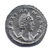 An important discovery regarding the chronology of this castrum is a Roman coin issued by Emperor Gallienus
(c. 218 AD – 268 AD), that represented his wife, Salonina
. This is a great indication that the castrum was still under Roman control in Gallienus' time and that it was probably abandoned only during the retreat from Dacia during Aurelian
(271 – 275 AD).
It was also the discovery site of a signum militare in the form of a hand made of bronze, wearing a representation of goddess Victoria
on the fingertips. The object is kept at the Iron Gates Region Museum.
The earlier excavations from 1885 led to other discoveries, including coins of Alexander Severus
, arrows and rings with inscriptions.
To the north and east of the castrum, were the canabae (Roman civil settlements), stretching over an area of about 20 ha.
A Roman road (Via Romana) was also identified. The road was connecting this site to Castrum Pinoasa, passing through the modern villages of Glogova
and Apa Neagră then heading towards Tismana River
.
However, there are two significant archeological sites cataloged by the Romanian National Institute of Historical Monuments: Cetatea Micului (LMI code DJ-I-s-B-07875), a Dacian fortress from late La Tène Period (1st century AD) and Piscul cazacilor (LMI code DJ-I-s-B-07876) site which includes a Dacian fortress (La Tène Period) and a Daco-Roman settlement (2nd - 4th century).
Piscul Cazacilor is one huge area (over two kilometres long) with lots with Roman artefacts, including pottery, bricks, and dressed stones. The site is placed in the northern third of the Piscul Cazacilor hill, and also on the left bank of the Paia River, to the north of the main site. Being perhaps a station, it includes the ancient Roman road connecting Drobeta
with Pelendava
, situated near the modern road coming from Botosesti Paia in the north.
Among the archaeological findings at the Paia river, there is evidence of the Mithraic cult practiced also in Dacia. A votive plaque has been recovered, with an inscription from which it can only be read gentilicum Valerius, probably a servus villicus (slave).
Another discovery is a good quality 9 cm bronze statuette depicting Mercury
, the god of trade, with hair in locks, small wings in the hair and a crown (not petasus) on the head. He stands with his weight on the right leg, while the head tilts slightly to the right. The right arm hangs along the body. A corner of the mantle can be seen on the left shoulder, hanging along the arm and folding on the forearm. The statuette is in the inventory of Iron Gates Region Museum.
Archaeological investigations at Butoiești in 1884 revealed traces of Roman civilization.
Danube
The Danube is a river in the Central Europe and the Europe's second longest river after the Volga. It is classified as an international waterway....
and included in the Roman
Ancient Rome
Ancient Rome was a thriving civilization that grew on the Italian Peninsula as early as the 8th century BC. Located along the Mediterranean Sea and centered on the city of Rome, it expanded to one of the largest empires in the ancient world....
road network, after the conquest of Dacia
Dacia
In ancient geography, especially in Roman sources, Dacia was the land inhabited by the Dacians or Getae as they were known by the Greeks—the branch of the Thracians north of the Haemus range...
.
The name is homonymous with the ancient name of the nearby Motru River
Motru River
The Motru River is a tributary of the Jiu River in the Southwest of Romania. The hydrological basin of the Motru has an area of 1874 km²...
. Its possible position at this river's junction gives a certain importance.
Ptolemy's Geographia
Amutria is mentioned in PtolemyPtolemy
Claudius Ptolemy , was a Roman citizen of Egypt who wrote in Greek. He was a mathematician, astronomer, geographer, astrologer, and poet of a single epigram in the Greek Anthology. He lived in Egypt under Roman rule, and is believed to have been born in the town of Ptolemais Hermiou in the...
's Geographia (c. 150 AD) in the form Amutrion as an important Dacian town, at latitude 50° 00' N and longitude 44° 45' E (note that he used a different meridian
Meridian (geography)
A meridian is an imaginary line on the Earth's surface from the North Pole to the South Pole that connects all locations along it with a given longitude. The position of a point along the meridian is given by its latitude. Each meridian is perpendicular to all circles of latitude...
and some of his calculations were off). It is located on a road between Drubetis and Potulatensioi.
Tabula Peutingeriana
Amutria is also depicted in the Tabula PeutingerianaTabula Peutingeriana
The Tabula Peutingeriana is an itinerarium showing the cursus publicus, the road network in the Roman Empire. The original map of which this is a unique copy was last revised in the fourth or early fifth century. It covers Europe, parts of Asia and North Africa...
(2nd century AD) between Drubetis and Pelendava
Pelendava
Pelendava was a Dacian town, today's Craiova, Romania.- See also :* Dacian davae* List of ancient cities in Thrace and Dacia* Dacia* Roman Dacia- External links :...
, on one of the three roads build by Emperor Trajan
Trajan
Trajan , was Roman Emperor from 98 to 117 AD. Born into a non-patrician family in the province of Hispania Baetica, in Spain Trajan rose to prominence during the reign of emperor Domitian. Serving as a legatus legionis in Hispania Tarraconensis, in Spain, in 89 Trajan supported the emperor against...
in Dacia. The road was connecting into Via Trajana and most likely crossing Trajan's Bridge
Trajan's bridge
Trajan's Bridge or Bridge of Apollodorus over the Danube was a Roman segmental arch bridge, the first to be built over the lower Danube. For more than a thousand years, it was the longest arch bridge in the world, in terms of both total and span length...
over the Danube. The location corresponds to the one mentioned by Ptolemy.
Etymology
RomaniaRomania
Romania is a country located at the crossroads of Central and Southeastern Europe, on the Lower Danube, within and outside the Carpathian arch, bordering on the Black Sea...
n archaeologist and historian Grigore Tocilescu
Grigore Tocilescu
Grigore George Tocilescu was a Romanian historian, archaeologist, epigrapher and folkorist, member of Romanian Academy....
, assumes that Amutria should be read Ad-mutriam, Ad Mutriam or Ad Mutrium, meaning by/at the Mutrium (Motru). The modern Romanian linguist Sorin Olteanu is also suggesting the form Ad Mutrius, with Mutrius possibly being the ancient name of Motru River.
Location
Amutria is hypothetically located at one of the following sites in OlteniaOltenia
Oltenia is a historical province and geographical region of Romania, in western Wallachia. It is situated between the Danube, the Southern Carpathians and the Olt river ....
(Southwestern Romania
Romania
Romania is a country located at the crossroads of Central and Southeastern Europe, on the Lower Danube, within and outside the Carpathian arch, bordering on the Black Sea...
):
- Valea Perilor, commune CătuneleCatuneleCătunele is a commune in Gorj County, Romania. It is composed of six villages: Cătunele, Dealu Viilor, Lupoaia, Steic, Valea Mănăstirii and Valea Perilor....
, Gorj County - MotruMotruMotru is a city in Romania, Gorj County.Motru is situated on the river of the same in western Oltenia. The county capital Târgu Jiu is located about 35 km northeast...
, Gorj CountyGorj CountyGorj is a county of Romania, in Oltenia, with its capital city at Târgu Jiu.- Demographics :In 2002, it had a population of 387,308 and its population density was 69/km².* Romanians – over 98%* Rromas, others.- Geography :... - Gura Motrului, commune ButoieştiButoiestiButoieşti is a commune located in Mehedinţi County, Romania. It is composed of eight villages: Argineşti, Butoieşti, Buiceşti, Gura Motrului, Jugastru, Pluta, Răduţeşti and Ţânţaru....
, Mehedinţi CountyMehedinti CountyMehedinţi is a county of Romania. It is mostly located in the historical province of Oltenia, with one municipality and three communes located in the Banat... - Botoşeşti-Paia, Dolj CountyDolj CountyDolj -Jiu, "lower Jiu", toward Gorj ) is a county of Romania, in Oltenia, with the capital city at Craiova .- Demographics :In 2002, it had a population of 734,231 and a population density of 99/km²....
Valea Perilor/Cătunele
Based on the archaeological survey and excavations performed at Cătunele in 1885, 1973, and later in 1981-84, a Roman castrum and civilian settlement was discovered.The castrum lies in the Valea Perilor village, on an alluvial terrace of the Motru river, approximately 130 meters from the highway that connects the modern towns of Motru
Motru
Motru is a city in Romania, Gorj County.Motru is situated on the river of the same in western Oltenia. The county capital Târgu Jiu is located about 35 km northeast...
and Baia de Aramă
Baia de Arama
Baia de Aramă is a small Romanian town located in the Wallachian county of Mehedinţi with a population of 5,724. The Brebina River runs through the town...
. It is bordered in the east by the Chivădarul River and was intended to oversee the Valea Motrului mountainous region inhabited by a large Dacian population.
The archaeological site is cataloged as Chivadarul (LMI code GJ-I-s-B-09155) by the Romanian National Institute of Historical Monuments in the List of historical monuments in Romania.
The shape of the castrum is rectangular with rounded corners, with the dimensions 156 x 114 m2. The castum is aligned lengthwise with the north-south axis, with the Porta Praetoria on the southern side.
The first systematic research was made in 1973 by the Iron Gates Region Museum
Iron Gates Region Museum
Iron Gates Region Museum is a museum in Drobeta-Turnu Severin, Romania.In 1912, Professor Alexandru Bărcăcilă established the "History Museum of Traian High School", that moved in 1926 to the newly built construction near the Roman camp, that formerly had to shelter a museum named from then...
from Drobeta-Turnu Severin
Drobeta-Turnu Severin
Drobeta-Turnu Severin is a city in Mehedinţi County, Oltenia, Romania, on the left bank of the Danube, below the Iron Gates.The city administers three villages: Dudaşu Schelei, Gura Văii, and Schela Cladovei...
and the Institute of Archaeology, Bucharest and then continued during 1981-1984, done by Gorj County Museum in collaboration with the Institute of Archaeology in Bucharest.
On the territory of the castrum were discovered many sherd
Sherd
In archaeology, a sherd is commonly a historic or prehistoric fragment of pottery, although the term is occasionally used to refer to fragments of stone and glass vessels as well....
s of Roman and Dacian origin, indicating that the Dacians had coexisted with Roman soldiers and settlers. Some of the Dacian pottery was hand made while others were worked on the wheel. These two populations - Dacians and Romans formed the ethnogenesis
Ethnogenesis
Ethnogenesis is the process by which a group of human beings comes to be understood or to understand themselves as ethnically distinct from the wider social landscape from which their grouping emerges...
of the Romanian people and the archaeological evidence sustains this fact.
Gallienus
Gallienus was Roman Emperor with his father Valerian from 253 to 260, and alone from 260 to 268. He took control of the Empire at a time when it was undergoing great crisis...
(c. 218 AD – 268 AD), that represented his wife, Salonina
Cornelia Salonina
Julia Cornelia Salonina was an Augusta, wife of Roman Emperor Gallienus and mother of Valerian II, Saloninus, and Marinianus.-Early life:...
. This is a great indication that the castrum was still under Roman control in Gallienus' time and that it was probably abandoned only during the retreat from Dacia during Aurelian
Aurelian
Aurelian , was Roman Emperor from 270 to 275. During his reign, he defeated the Alamanni after a devastating war. He also defeated the Goths, Vandals, Juthungi, Sarmatians, and Carpi. Aurelian restored the Empire's eastern provinces after his conquest of the Palmyrene Empire in 273. The following...
(271 – 275 AD).
It was also the discovery site of a signum militare in the form of a hand made of bronze, wearing a representation of goddess Victoria
Victoria (mythology)
In ancient Roman religion, Victoria was the personified goddess of victory. She is the Roman equivalent of the Greek goddess Nike, and was associated with Bellona. She was adapted from the Sabine agricultural goddess Vacuna and had a temple on the Palatine Hill...
on the fingertips. The object is kept at the Iron Gates Region Museum.
The earlier excavations from 1885 led to other discoveries, including coins of Alexander Severus
Alexander Severus
Severus Alexander was Roman Emperor from 222 to 235. Alexander was the last emperor of the Severan dynasty. He succeeded his cousin Elagabalus upon the latter's assassination in 222, and was ultimately assassinated himself, marking the epoch event for the Crisis of the Third Century — nearly fifty...
, arrows and rings with inscriptions.
To the north and east of the castrum, were the canabae (Roman civil settlements), stretching over an area of about 20 ha.
A Roman road (Via Romana) was also identified. The road was connecting this site to Castrum Pinoasa, passing through the modern villages of Glogova
Glogova
Glogova is a commune in Gorj County, Romania. It is composed of five villages: Cămuieşti, Cleşneşti, Glogova, Iormăneşti and Olteanu....
and Apa Neagră then heading towards Tismana River
Tismana River
The Tismana River is a tributary of the Jiu River in Romania. The 4 km. long reach of the river, upstream of the Tismana Monastery is also known as Dorna River.-References:* Administraţia Naţională Apelor Române - Cadastrul Apelor - Bucureşti...
.
Botoşeşti-Paia
Locating Amutria at Botoşeşti, a site with a very rich evidence of a Roman presence, has a problem: it is not by the Motru river and does not fit the Ad Mutrium toponym connection.However, there are two significant archeological sites cataloged by the Romanian National Institute of Historical Monuments: Cetatea Micului (LMI code DJ-I-s-B-07875), a Dacian fortress from late La Tène Period (1st century AD) and Piscul cazacilor (LMI code DJ-I-s-B-07876) site which includes a Dacian fortress (La Tène Period) and a Daco-Roman settlement (2nd - 4th century).
Piscul Cazacilor is one huge area (over two kilometres long) with lots with Roman artefacts, including pottery, bricks, and dressed stones. The site is placed in the northern third of the Piscul Cazacilor hill, and also on the left bank of the Paia River, to the north of the main site. Being perhaps a station, it includes the ancient Roman road connecting Drobeta
Drobeta
Drobeta is a genus of moths of the Noctuidae family.-Species:* Drobeta albicauda * Drobeta albirufa * Drobeta andrevia * Drobeta atrisigna * Drobeta brephus Dyar, 1914...
with Pelendava
Pelendava
Pelendava was a Dacian town, today's Craiova, Romania.- See also :* Dacian davae* List of ancient cities in Thrace and Dacia* Dacia* Roman Dacia- External links :...
, situated near the modern road coming from Botosesti Paia in the north.
Among the archaeological findings at the Paia river, there is evidence of the Mithraic cult practiced also in Dacia. A votive plaque has been recovered, with an inscription from which it can only be read gentilicum Valerius, probably a servus villicus (slave).
Another discovery is a good quality 9 cm bronze statuette depicting Mercury
Mercury (mythology)
Mercury was a messenger who wore winged sandals, and a god of trade, the son of Maia Maiestas and Jupiter in Roman mythology. His name is related to the Latin word merx , mercari , and merces...
, the god of trade, with hair in locks, small wings in the hair and a crown (not petasus) on the head. He stands with his weight on the right leg, while the head tilts slightly to the right. The right arm hangs along the body. A corner of the mantle can be seen on the left shoulder, hanging along the arm and folding on the forearm. The statuette is in the inventory of Iron Gates Region Museum.
Gura Motrului/Butoieşti
Romanian journalist and historian Petru Broșteanu, as well as other authors, placed Amutria at Gura Motrului, which in Romanian literally means the mouth of River Motru, based on measurements made out of Tabula Peutingeriana, and other sources. The location also fits well with the Ad Mutrium interpretation of the name.Archaeological investigations at Butoiești in 1884 revealed traces of Roman civilization.
See also
- DaciaDaciaIn ancient geography, especially in Roman sources, Dacia was the land inhabited by the Dacians or Getae as they were known by the Greeks—the branch of the Thracians north of the Haemus range...
- Roman DaciaRoman DaciaThe Roman province of Dacia on the Balkans included the modern Romanian regions of Transylvania, Banat and Oltenia, and temporarily Muntenia and southern Moldova, but not the nearby regions of Moesia...
- List of ancient cities in Thrace and Dacia
- Dacian davaeDava (Dacian)Dava is a Geto-Dacian name for a city, town or fortress. Generally, the name indicated a tribal center or an important settlement, usually fortified...
External links
- Ptolemy's Geography at LacusCurtius - Book III, Chapter 8 Location of Dacia (from the Ninth Map of Europe) (English translation, incomplete)
- Castrele romane din Gorj lasate în paragina (Romanian)
- Dacian fortresses, settlements and Roman castra from Romania: Google Maps / Google Earth