

Akureyri
Encyclopedia
Akureyri ˈaːkʰʏrˌeiːrɪ is a town in northern Iceland
Iceland
Iceland , described as the Republic of Iceland, is a Nordic and European island country in the North Atlantic Ocean, on the Mid-Atlantic Ridge. Iceland also refers to the main island of the country, which contains almost all the population and almost all the land area. The country has a population...
. It is Iceland's second largest urban area (after the Greater Reykjavík area
Greater Reykjavík Area
The Greater Reykjavík Area is a name used collectively for Reykjavík and seven municipalities around it.. The area is the largest urban area in Iceland. Each municipality has its independent elected council. With a population of 200,852, the Greater Reykjavík Area comprises over 60% of the...
) and fourth largest municipality
Municipalities of Iceland
The municipalities of Iceland are local administrative areas in Iceland that provide a number of services to their inhabitants such as kindergartens, elementary schools, waste management, social services, public housing, public transportation, services to senior citizens and handicapped people...
(after Reykjavík
Reykjavík
Reykjavík is the capital and largest city in Iceland.Its latitude at 64°08' N makes it the world's northernmost capital of a sovereign state. It is located in southwestern Iceland, on the southern shore of Faxaflói Bay...
, Hafnarfjörður
Hafnarfjörður
Hafnarfjörður is a port town and municipality located on the south-west coast of Iceland, about 10 km south of Reykjavík....
, and Kópavogur
Kópavogur
Kópavogur is a city and Iceland's second largest municipality, with a population of 30,779.It lies immediately south of Reykjavík and is part of the Greater Reykjavík Area. The name literally means seal pup bay...
).
Nicknamed the Capital of North Iceland, Akureyri is an important port and fishing centre, with a population of 17,754.
The area where Akureyri is located was settled in the 9th century but did not receive a municipal charter until 1786. The town was the site of Allied units during World War II. Further growth occurred after the war as the Icelandic population increasingly moved to urban areas.
The area has a relatively warm climate due to geographical factors, and the town's ice-free harbor has played a significant role in its history.
History
Norsemen
Norsemen is used to refer to the group of people as a whole who spoke what is now called the Old Norse language belonging to the North Germanic branch of Indo-European languages, especially Norwegian, Icelandic, Faroese, Swedish and Danish in their earlier forms.The meaning of Norseman was "people...
Viking Helgi magri (the slim) Eyvindarson originally settled the area in the 9th century. The first mention of Akureyri is in court records from 1562 when a woman was sentenced there for adultery. In the 17th century, Danish merchants based their camps at the current site of Akureyri, which was one of the numerous spits of land in Pollurinn. The main reasons for choosing this spot for trading operations were the outstanding natural harbour and the fertility of the area. The merchants did not live at Akureyri year round but returned home in the winter.
Permanent settlement at Akureyri started in 1778, and eight years later, the town was granted its municipal charter by the king of Denmark (and at the time Iceland also) along with five other towns in Iceland. The king hoped to improve the living conditions of Icelanders by this action because at the time, Iceland had never had urban areas. As far as the king was concerned Akureyri was unsuccessful, because it did not grow from its population of 12. It lost its municipal status in 1836 but regained it in 1862. From then on Akureyri started to grow because of the excellent port conditions and perhaps more because of the productive agricultural region around it. Agricultural products became an important sector of the economy.

World War II
World War II, or the Second World War , was a global conflict lasting from 1939 to 1945, involving most of the world's nations—including all of the great powers—eventually forming two opposing military alliances: the Allies and the Axis...
, Akureyri was one of three air bases used by the Norwegian-British No. 330 Squadron RNoAF. The squadron, which was formed on 25 April 1941, flew Northrop N-3PB
Northrop N-3PB
The Northrop N-3PB Nomad was a single-engined American floatplane of the 1940s. Northrop developed the N-3PB as an export model based on the earlier Northrop A-17 design. A total of 24 were purchased by Norway, but were not delivered until after the Fall of Norway during the Second World War...
bombers: 'A' flight was based at Reykjavik
Reykjavík Airport
Reykjavík Airport Reykjavík Airport Reykjavík Airport (Icelandic: Reykjavíkurflugvöllur, is the chiefly domestic airport serving Reykjavík, Iceland. The airport lies two kilometres from Reykjavík's city centre. Possessing rather short runways, it normally only serves flights within Iceland and to...
, 'B' flight at Akureyri and 'C' flight at Budareyri. On 1 December 1940, 'A' and 'B' flights ceased operating from Norwegian bases, but 'C' flight continued to fly Northrop N-3PBs from Akureyri until 5 April 1943. No. 330 Squadron RNoAF also operated Catalina
PBY Catalina
The Consolidated PBY Catalina was an American flying boat of the 1930s and 1940s produced by Consolidated Aircraft. It was one of the most widely used multi-role aircraft of World War II. PBYs served with every branch of the United States Armed Forces and in the air forces and navies of many other...
flying boats from Akureyri, which protected convoys from the United States to the United Kingdom and Murmansk
Murmansk
Murmansk is a city and the administrative center of Murmansk Oblast, Russia. It serves as a seaport and is located in the extreme northwest part of Russia, on the Kola Bay, from the Barents Sea on the northern shore of the Kola Peninsula, not far from Russia's borders with Norway and Finland...
from attack by German submarines.
In the 20th century, Iceland experienced a mass exodus from the countryside to the towns. Commerce and service industries grew to be the primary employers in Akureyri in the 1990s. Jón Sveinsson
Jón Sveinsson
Jón "Nonni" Stefán Sveinsson was an Icelandic children's writer and member of the Society of Jesus....
, a popular author of children's books, was born in Akureyri and died in 1944.
In the early 21st century, fishing industries have become more important in Akureyri as two of the major fishing companies of Iceland have become a more important source of revenue and are expected to grow further in coming years. The University of Akureyri
University of Akureyri
The University of Akureyri is a young institution, founded on September 5, 1987 in the city of Akureyri in the north part of Iceland. It has grown since then, especially in the last few years as more facilities have been established...
was founded in 1987 and is growing rapidly. Akureyri is also the home of RES - The School for Renewable Energy Science
RES - The School for Renewable Energy Science
RES - The School for Renewable Energy Science is a private, non-profit, international graduate school located in the city of Akureyri in northern Iceland and shares its facilities with the University of Akureyri....
.
Since 2004, the former municipality of Hrísey
Hrísey
Hrísey is a small island off the north coast of Iceland, situated approximately 35 kilometres north of Akureyri, in Eyjafjörður, at .Since 2004, the island has been a part of the municipality of Akureyri, having previously been a municipality in its own right.Hrísey itself has a total land area of...
, an island 35 km to the north, has been a part of Akureyri. Hrísey, which has a population of 210, is the second largest island off Iceland and is a site for pet and livestock quarantine. The settlement was previously the site of fishing processing. The town is located on the southern part of the island. The northern part consists on privately owned land that requires passes to enter.
Geography
Fjord
Geologically, a fjord is a long, narrow inlet with steep sides or cliffs, created in a valley carved by glacial activity.-Formation:A fjord is formed when a glacier cuts a U-shaped valley by abrasion of the surrounding bedrock. Glacial melting is accompanied by rebound of Earth's crust as the ice...
Eyjafjörður
Eyjafjörður
Eyjafjörður is the longest fjord in central northern Iceland. It is located in the second most populous region of Iceland.-Physical geography:...
.
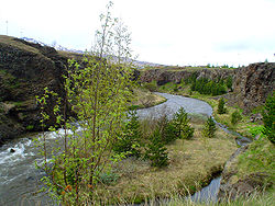
It is surrounded by mountains, the highest being Kista (1447 metres) and another peak of 1538 metres at the head of Glerádalur. There is a narrow coastal strip of flat land; inland is a steep but low hill. In earlier times a few spits of land (Icelandic: eyri, thus Akur-eyri) jutted from the narrow coast, but a lot of land has since been reclaimed from the sea so that today the coastline is more even except for the largest, Oddeyri, which was formed by the river Glerá
Glerá
Glerá River is a river in northern Iceland. It originates from glaciers in the mountains of Tröllaskagi peninsula and also draws water from some fresh water springs on its way down Glerá Valley. It runs through the town of Akureyri before it flows into the sea in Eyjafjörður. The river formed the...
which runs through the town. It is thought that the name of the town is derived possibly from the name of a field which may have been situated near some of the sheltered locations by the river.
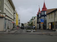
The body of sea between Oddeyri and the end of the fjord is known as Pollurinn ("the Pool") and is known for calm winds and a good natural harbour. Akureyri today is centered on Ráðhústorg (Town Hall Square) near the north-west corner of Pollurinn. The districts of Akureyri are: Innbær, the oldest part of town on the strip of land between the hill and Pollurinn south of the central area; Brekkan, on top of the hill; Oddeyri on the peninsula with the same name; and Glerárhverfi on the north bank of the Glerá (also referred to colloquially as Þorpið, 'the Village'). Because of the town's position at the end of a long fjord surrounded by high mountains, the climate is actually more inland than coastal, meaning greater variations in temperature (warmer summers, colder winters) than in many other inhabited parts of Iceland. However the mountains shield the town from strong winds. The relatively warm climate (for its latitude) allows the Botanical Gardens to flourish without need of a greenhouse. The area around Akureyri has one of the warmest climates in Iceland even though it is merely 100 km (62.1 mi) from the Arctic Circle.
Climate
Akureyri has a subpolar oceanic climate with cold though not severe winters and mild summers. The snow cover starts forming in late October and melts in April, yet snow on the mountain peaks around Akureyri can stay for the whole year. Akureyri is a very cloudy town, averaging only 1047 sunshine hours annually, with barely any sunshine between November and February, but precipitation is much lower than in southern Iceland because the prevailing winds are from the south - it is as little as a fifth as much as in Vík í MýrdalVík í Mýrdal
The village of Vík is the southernmost village in Iceland, located on the main ring road around the island, around by road SSE of Reykjavík....
.
Demographics
Akureyri has a population of 17,304 based on the 1 April 2008 census. The population in 1910 was 2,239, increasing to 7,711 in 1950 and 16,756 in 2005. 20% of the working population is employed in service industries. The January 1, 2008 population of the 600 postal code area (Akureyri) was 9,759. The January 1, 2008 population of the 601 postal code area (Akureyri) was 2,213. The January 1, 2008 population of the 603 postal code area (also Akureyri) was 7,375. Postal code 602 is used for post office boxes and is not associated with a specific geographical area. There were 8,541 males and 8,779 females in Akureyri on 1 January 2008. Deaths that year in Akureyri totaled 44 males and 79 females. In 2008, 1,098 moved from Akureyri but this migration was offset by a net migration into Akureyri of 78 people.Crime
Crime statistics have been published by the Iceland national police for 2000. Akureyri had a reported 726 non-traffic offenses per 10,000 population compared with a national average of 892, while 2,891 traffic offenses per 10,000 population were recorded compared with a national average of 2,397. Akureyri has five police officers on call. There have been incidents when there were insufficient police officers on duty to respond to criminal activity in progress, as confirmed by the mayor. However, Akureyri, and Iceland in general, has one of the lowest crime rates in the world.Economy
The fishing industry has historically been a large and important part of the local economy. In recent years, other industry and business services have also begun. Higher education is also a growing sector in the local economy. Twenty percent of the work force is in the service industry.Two of the five largest fishing companies in Iceland are headquartered in Akureyri. The ice-free port is a contributing factor. Other large companies in Akureyri include Samherji
Samherji
Samherji is the second biggest company in the Icelandic fish industry and was founded in Grindavík in 1972. Its headquarters are located in Akureyri but the company operates in many places in Iceland and also throughout the world. One of its companies is the sales company Seagold Ltd...
, Norðurmjólk, Brim hf, and Vífilfell
Vífilfell
Vífilfell is the Icelandic franchisee for brands of The Coca-Cola Company. Those brands include Coca-Cola, Sprite, Fanta, Fresca, Powerade, Magic and Burn. Vífilfell also produces some beer brands along with local fruit juices and a chocolate milk drink Kappi....
, the largest brewery in Iceland. Sjúkrahús Akureyrar (FSA/Akureyri Hospital) is a major employer in the area and is one of two major hospitals in Iceland.
Corporations pay a tax rate of 18% to the national government, which is one of the lowest in the world. There are no additional local corporate taxes. Property tax, at 1.99%, accounts for most of the tax base. A local government deficit of ISK 1 billion (US$ 9 million) was anticipated in 2009 prompting a cut in salaries of the mayor, town councilors, and committee members by 10% and increases in local taxes and property taxes.
Culture
Akureyri has a robust cultural scene, with several bars and reputable restaurants (such as "Greifinn", "Bautinn", "RUB 23 Steak/Sushi", "Kung Fu sushi bar" and "Götubarinn"). The Icelandic folk dance ensemble "Vefarinn" comes from Akureyri. Folk culture in general is more prevalent in Akureyri than in Reykjavík. During the summer there are several festivals in Akureyri and its surroundings. One example is the medieval festival held every summer at Gásir. The Akureyri International Music Festival, a concert series by bands, was held for the fourth time in 2009. The town has one of the largest libraries in the country. The Arctic Open Golf Championship is an international event that is held in Akureyri.Media
The Vikudagur newspaper is published in Akureyri. Icelandic National Broadcasting Service (Ríkisútvarpið) operates two radio channels nationwide. There are several radio stations in Akureyri, including FM Akureyri and Voice FM 98.7. Several television stations that can be watched in Akureyri. N4 is a station whose studios are located in Akureyri. Initially a local channel, it began to broadcast nationwide in 2008.Townscape
Local museums include the Minjasafnið á Akureyri (Akureyri Museum), Listasafnið á Akureyri (Akureyri Art Museum), Nonnahús (Nonni house or Jón Sveinsson Memorial Museum, for the writer), Davíðshús (David's house or Davíð Stefánsson Memorial Museum, for the poet), Akureyri Museum of Industry, a motorcycle museum, and Flugsafn Íslands (Aviation Museum). The most northerly botanical gardens and the most northerly 18 hole golf course in the world are in the town. The Náttúrufræðistofnun Norðurlands (Nature Museum) was opened in 1957 and is in the grounds of the Botanical Gardens. The Botanical Gardens (Lystigarður Akureyrar) are located in Spítalavegur. Large churches include the Akureyrarkirkja
Akureyrarkirkja
Akureyrarkirkja or The Church of Akureyri is a prominent Lutheran church in Akureyri, northern Iceland. Located in the centre of the city, and towering above the city on a hill, it was designed by Guðjón Samúelsson, and completed in 1940....
(The church of Akureyri) and Glerárkirkja
Glerárkirkja
Glerárkirkja is a church in Akureyri, Iceland. Designed by Svanur Eiríksson it covers an area of 2100 m².-External links:*...
(The church of Glerá). Sundlaug Akureyrar is a swimming pool in Akureyri.
New residential and commercial growth has required an extension of electricity and water distribution as well as new water drilling. Much of the town is heated geothermally.
Law and government
Akureyri is governed by a town council, directly elected by those over 18 with registered domicile in the town. The council has 11 members who are elected for four-year terms. The mayor is appointed by the council: usually one of the council members is chosen, but they may also appoint a mayor who is not a member of the council.The last elections to the town council were held on May 29, 2010. The People's List received the most votes and also a majority of the seats in the council, 6 out of 11. It was the first time since the current election system was introduced in 1930 that one party list had won an outright majority on the council. The Independence Party
Independence Party (Iceland)
The Independence Party is a centre-right political party in Iceland. Liberal conservative and Eurosceptic, it is the second-largest party in the Althing, with sixteen seats. The chairman of the party is Bjarni Benediktsson and vice chairman is Ólöf Nordal....
(Sjálfstæðisflokkurinn) lost three representatives on the council and lost its position as the largest party; the other three parties also lost votes and most of them lost seats. Social Democratic Alliance (Samfylkingin) lost two seats and Left-Green Movement
Left-Green Movement
The Left-Green Movement is a left-wing political party in Iceland.It was founded in 1999 by a few members of Alþingi who did not approve of the planned merger of the left parties in Iceland that resulted in the founding of the Social Democratic Alliance...
(Vinstri hreyfingin grænt framboð) lost one while the Progressive Party kept its one seat and the new list formed by Sigurður Guðmundsson, The Town List, won one seat. Following the elections the People's List advertised for a new mayor. 53 put their names forward. The current mayor is Eiríkur Björn Björgvinsson.
Timeline of mayors
- 1919–1934 - Jón Sveinsson
- 1934–1958 - Steinn Steinsen
- 1958–1967 - Magnús Guðjónsson
- 1967–1976 - Bjarni Einarsson
- 1976–1986 - Helgi M. Bergs
- 1986–1990 - Sigfús Jónsson
- 1990–1994 - Halldór Jónsson
- 1994–1998 - Jakob Björnsson
- 1998–2007 - Kristján Þór JúlíussonKristján Þór JúlíussonKristján Þór Júlíusson is an Icelandic politician and a member of Alþingi. He completed degrees in Icelandic, literature and teaching at the University of Iceland but most of his education has been concerned with seamanship...
- 2007–2009 - Sigrún Björk Jakobsdóttir
- 2009–2010 - Hermann Jón Tómasson
- 2010– - Eiríkur Björn Björgvinsson
Twin cities
The following cities or towns have been designated twin cities with Akureyri:Ålesund, Norway Lahti
Lahti
Lahti is a city and municipality in Finland.Lahti is the capital of the Päijänne Tavastia region. It is situated on a bay at the southern end of lake Vesijärvi about north-east of the capital Helsinki...
, Finland Murmansk
Murmansk
Murmansk is a city and the administrative center of Murmansk Oblast, Russia. It serves as a seaport and is located in the extreme northwest part of Russia, on the Kola Bay, from the Barents Sea on the northern shore of the Kola Peninsula, not far from Russia's borders with Norway and Finland...
, Russia Randers
Randers municipality
Randers Municipality is a municipality in Region Midtjylland on the Jutland peninsula in central Denmark. The municipality covers an area of 793 km², and has a total population of 94,750 . Its mayor is Henning Jensen Nyhuus, a member of the Social Democrats...
, Denmark Västerås
Västerås Municipality
Västerås Municipality is a municipality in Västmanland County in central Sweden. Its seat is located in the city of Västerås....
, Sweden Çeşme
Çesme
Çeşme is a coastal town and the center-town of the district of the same name in Turkey's western-most end, on a promontory on the tip of the peninsula which also carries the same name and which extends inland to form a whole with the wider Karaburun Peninsula...
, Turkey
Turkey
Turkey , known officially as the Republic of Turkey , is a Eurasian country located in Western Asia and in East Thrace in Southeastern Europe...
In 2007, a friendship and fisheries agreement was signed with Grimsby, United Kingdom which, according to Ice News, might lead to a twin cities designation in the future.
Education
There are two high schools (gymnasiums) in Akureyri, one of them being the second oldest in Iceland. The Menntaskólinn á AkureyriAkureyri Junior College
Akureyri Junior College is an Icelandic gymnasium . It is one of the oldest educational institutions in Iceland.It is located in Akureyri, "the Capital of the North", and traces its origin back to the school in Möðruvellir in the valley of Hörgárdalur, which was founded in 1880...
is a junior college in Akureyri and so is the Verkmenntaskólinn á Akureyri.
Háskólinn á Akureyri (University of Akureyri)
University of Akureyri
The University of Akureyri is a young institution, founded on September 5, 1987 in the city of Akureyri in the north part of Iceland. It has grown since then, especially in the last few years as more facilities have been established...
is a university located in Akureyri that was founded in 1987. There are 3 faculties or colleges, the Faculty of Business and Science, Faculty of Humanities and Social Sciences and Faculty of Health Sciences.
The RES - The School for Renewable Energy Science
RES - The School for Renewable Energy Science
RES - The School for Renewable Energy Science is a private, non-profit, international graduate school located in the city of Akureyri in northern Iceland and shares its facilities with the University of Akureyri....
, established in 2006, is also located in the town. This school offers graduate degrees in cooperation with two Icelandic universities.
Airports
Akureyri Airport, one of four international airports in Iceland and the only international airport in the north of the country, was constructed in 1955 replacing the airstrip at Melgerdismelar further to the south. The current airport is mostly used for domestic flights, with seasonal scheduled international flights. Air IcelandAir Iceland
Air Iceland is a regional airline with its head office on the property of Reykjavík Airport in Reykjavík, Iceland. It operates scheduled services to domestic destinations and to Greenland. Its main bases are Reykjavík Airport and Akureyri Airport...
flies several times a day to Reykjavík
Reykjavík Airport
Reykjavík Airport Reykjavík Airport Reykjavík Airport (Icelandic: Reykjavíkurflugvöllur, is the chiefly domestic airport serving Reykjavík, Iceland. The airport lies two kilometres from Reykjavík's city centre. Possessing rather short runways, it normally only serves flights within Iceland and to...
, and there are also flights to Grimsey
Grímsey
Grímsey is a small island in the country of Iceland, off the north coast of the main island of Iceland and straddling the Arctic Circle. In January 2011 it had 86 inhabitants....
, Vopnafjörður
Vopnafjörður
Vopnafjörður is a village and municipality in Northeast Iceland, standing on a peninsula in the middle of a mountainous bay by the same name. The main industries of Vopnafjordur are fish processing, agriculture, and tourism and other services....
and Þórshöfn
Þórshöfn
Þórshöfn is a small fishing village in northeast Iceland, located on the northern coast of the Langanes peninsula on the Þistilfjörður bay.The village has a population of 380 people. It is the administrative centre of Langanesbyggð municipality and of the neighbouring Svalbarðshreppur municipality...
. Since 2006, Iceland Express
Iceland Express
Iceland Express is a low-fare airline headquartered in Reykjavík, Iceland. It operates services to 17 destinations in Europe and North America using leased aircraft...
has operated scheduled flights from Akureyri to Copenhagen during the summer.
In 2007, Akureyri Airport had a passenger traffic level of 221,200 and 19,778 aircraft movements.
Marine port
The port of Akureyri is vital to the town, which largely bases its livelihood on fisheries. It is the site of large fish processing plants and has docking facilities for trawlers. It is also important for freight handling and for tourismTourism
Tourism is travel for recreational, leisure or business purposes. The World Tourism Organization defines tourists as people "traveling to and staying in places outside their usual environment for not more than one consecutive year for leisure, business and other purposes".Tourism has become a...
, as cruise ship
Cruise ship
A cruise ship or cruise liner is a passenger ship used for pleasure voyages, where the voyage itself and the ship's amenities are part of the experience, as well as the different destinations along the way...
s stop in Akureyri during the summer months. The ice-free nature of the port has been important in the town's establishment.
Bus
SBA-Norðurleið (Icelandic Bus Company - northern route) is an Akureyri-based company that provides a bus service to the town. Local bus services within Akureyri are provided by the SVA (Akureyri Bus Company), which does not charge fares. The cessation of fares in 2008 resulted in an increase of 130% in passenger numbers compared to the previous year when fares were charged.Roads
Route 1 or the Ring Road (Þjóðvegur 1 or Hringvegur) connects the town with the other parts of the country, including Reykjavik, which is 390 km away. The road is mostly one lane in each direction, but is paved and open year round. There are no paved roads from Akureyri to the unpopulated interior of the island. However, the F821 mountain road is open in summer: it climbs southwards from Akureyri and connects with the F26 mountain road across the interior to the SW of the country.Parking in the central area requires use of a parking disc indicating the time that parking has commenced. Parking is free but is limited in certain areas to a maximum period ranging from 15 minutes to 2 hours.
Utilities
Akureyri has been heated geothermally since the late 1970s. Starting in 1928, there were unsuccessful attempts to develop geothermal energy. During this period, electricity and oil were used for heating. Construction of a geothermal distribution system was begun in 1976 after the discovery of a commercially viable source in 1975. Distribution was widespread by 1979.The Laugaland field near Akureyri was the first geothermal source commercially developed. The Ytri-Tjarnir field followed. To obtain sufficient water flow, additional fields were developed at Botn in 1980, Glerárdalur 2 km west of the town in 1981, and Þelamörk 10 km north of the town in 1992. Water temperature is generally 65–75 C but can drop to 45 C during hot summer days. The cost of geothermal production is, at 32 mill/kwh, higher than the Icelandic national average of 11, but slightly less than the cost of imported heating oil. There is diminishing excess capacity but there are known and untapped resources near the town. Furthermore, there have been proposals to reinject water to extend the life of the sources.