
.gif)
A7 (Croatia)
Encyclopedia
The A7 motorway is a 34.4 kilometres (21.4 mi) long motorway in Croatia
. It connects the nation's largest port in Rijeka
, to the Croatian motorway network, as well as to the Rupa
and Pasjak
border crossings to Slovenia
. The motorway forms part of a longitudinal transportation corridor in Croatia, and it is a part of European route E61
Villach
–Ljubljana
–Trieste
–Rijeka. The A7 motorway route south of Orehovica interchange
, where it also intersects Pan-European corridor Vb
, is a part of European route E65
.
The A7 motorway runs near a number of Croatian cities and provides access to Učka Nature Park
and, indirectly, to numerous resorts in the Istria
and Kvarner Gulf
regions. The motorway is nationally significant because of its positive economic impact
on the cities and towns it connects, and because of its contribution to tourism in Croatia
. The importance of the motorway as a transit route will be further increased upon completion of a proposed expansion of the Port of Rijeka
and Rijeka transport node.
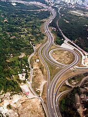
The motorway consists of two traffic lanes and an emergency lane in each driving direction, separated by a central reservation
. There are no emergency lanes in the tunnels. All intersections of the A7 motorway are grade separated
. Numerous bridges, viaduct
s, tunnels, and other structures were required as the route traverses rugged terrain. As of 2010, there are ten exits and two rest area
s situated along the route. Most of the motorway is not tolled
, but a single section is tolled using an open toll system with pricing tied to vehicle classification
.
Plans for the motorway were officially formulated in 1974 and the construction was started in 1977. The first 8.3 kilometres (5.2 mi) sections were completed as a two-lane expressway with grade-separated intersections, in 1988 and 1990, comprising the western arm of Rijeka bypass. As the first stage of the A6 motorway construction spanning between Zagreb and Rijeka neared completion in the 2000s, construction of a proper motorway along the A7 route started. In December 2009, the Diračje
–Orehovica
section was upgraded to a six-lane motorway, bringing the entire route between Rupa border crossing and Sveti Kuzam interchange to a uniform standard.
Two new sections of the A7 motorway are currently under construction, extending the route eastward into vicinity of Kraljevica
, Crikvenica
, and Krk Bridge
. The two sections are scheduled to be completed by 2012. Current long-term plans for developing the A7 motorway define its ultimate southern terminus in Žuta Lokva
at the interchange of the A1 motorway
. This section is no longer part of any short-term plans, as no funding until 2012 is currently scheduled for the section. Further long term plans specify an outer Rijeka bypass and a new interchange with the A8 expressway.
, connecting the nation's largest port and the city of Rijeka
to the Slovenia
n road network at the Rupa
border crossing. The A7 motorway currently connects to the rest of the Croatian motorway network via the A6 motorway
in Orehovica interchange
. The motorway is a part of International E-road network
routes E65
and E61
. The sections south of Orehovica interchange are a part of the E65, while the remaining sections are a part of the E61.
The motorway is of major importance to Croatia in terms of its development of the economy of Croatia
, most notably in tourism
, as it represents the shortest and the most convenient route between Trieste
, Italy
or Ljubljana
, Slovenia and the Adriatic Sea
. This particularly applies to tourist resorts in the Kvarner Gulf
area and to the Port of Rijeka, but it is also true for resorts in Istria
, served via the A8 expressway. The genuine importance of the motorway as a transit route will be demonstrated upon completion of the A7 route to Žuta Lokva
interchange of the A1 motorway
and proposed expansion of the Port of Rijeka
and Rijeka transport node. The former is planned as a part of completion of the Adriatic–Ionian motorway, while the latter is planned to encompass the growth of the Port of Rijeka's cargo handling capacity, improved railroad links and a new Rijeka bypass motorway linking the A7, via a number of new interchanges, to the A6
and A8 motorways. The project is, among other goals, aiming to increase traffic along the Croatian part of Pan-European corridor Vb
, which connects to the A7 near Rijeka.
As of November 2010, the motorway spans 34.4 kilometres (21.4 mi) between the Rupa border crossing to Slovenia and Sveti Kuzam interchange where southbound A7 traffic defaults to the D40 state road. It connects to Rijeka
as it forms Rijeka bypass, the A8 expressway of the Istrian Y
and the A6 which represents motorway connection to Zagreb
and Split. Future development of the motorway will include southward extensions of the motorway towards Crikvenica
, Novi Vinodolski
, Senj
, and ultimately Žuta Lokva interchange on the A1 motorway. The A7 motorway consists of two traffic lanes and an emergency lane in each driving direction along its entire length, except in tunnels where there are emergency bays rather than lanes. All existing interchanges are trumpet interchanges. There are two rest area
s along the motorway, providing various types of services ranging from parking spaces and restrooms to filling station
s and restaurants. As of October 2010, the motorway has 10 interchanges, providing access to a number of towns and cities and to the Croatian state road network. The motorway is operated by Autocesta Rijeka – Zagreb.
An automatic traffic monitoring and guidance system is in place along the motorway. It consists of measuring, control, and signaling devices, located in zones where driving conditions may vary—at interchanges, near viaducts, beside bridges, in tunnels, and in zones where fog and strong winds are known to occur. The system consists of variable trafic signs used to communicate changing driving conditions, possible restrictions, and other information to motorway users.
The A7 motorway runs through hills, rugged coastal terrain, and urban areas, requiring a substantial number of bridges, viaducts, and tunnels along the route. Particular attention to the environment is also required since the route is situated in karst topography
, which is particularly susceptible to water pollution, and the urbanized areas requiring special attention to be paid to noise pollution
. Noise pollution was assessed as especially severe in the Rastočine neighborhood of Rijeka, where residential buildings are particularly close to the motorway route, most notably a 26 story high-rise only 40 metres (131.2 ft) away from the route. The noise pollution was addressed by building a noise barrier 352 metres (1,154.9 ft) long which largely encloses that motorway section like a tunnel. Curved overhead sections of the noise barrier are covered with 2300 sqm of solar panels with annual electricity production capacity of 248,000 kWh.
based on the vehicle classification in Croatia
using an open toll system in place between the Rupa and Jurdani
interchanges. The toll is payable in Croatian kuna
, euro
s, and major credit and debit cards. A number of prepaid toll collection systems are also used, including various types of smart cards issued by the motorway operator and ENC—an electronic toll collection (ETC)
system which is shared by most motorways in Croatia and provides drivers with discounted toll rates for dedicated lanes at toll plazas.
As of December 2010, Autocesta Rijeka–Zagreb collects toll on a single section of the motorway, between Rupa and Jurdani interchanges, close to the northern terminus of the motorway. Unlike those sections further south, which are used as bypass road of the city of Rijeka, therefore carrying substantial suburban and commuter traffic, the tolled section carries almost exclusively transit traffic. The Rupa toll plaza, located on the section reported 240,975 kuna (€ 32,400) collected during a single, peak season, weekend in July. Even though motorway traffic volume and thus toll revenue, decreased slightly elsewhere in the country, this particular tolled section reported virtually no change in income by 2010.
s. A significant number of interchanges present along Rijeka bypass the 18 kilometres (11.2 mi) A7 section between Matulji and Sveti Kuzam which consists of seven interchanges (including the Orehovica interchange with the A6 motorway), thus yielding an average distance of only 3 kilometres (1.9 mi) between them.
The longest structures on the A7 motorway are the 858 metres (2,815 ft) Trsat Tunnel located on the Orehovica interchange
–Škurinje
section, the 595 metres (1,952.1 ft) Škurinje II Tunnel situated between Škurinje and Rujevica
exits, and the 588 metres (1,929.1 ft) Vežica Viaduct built on Orehovica–Draga section of the motorway. Rječina Bridge, a 210 metres (689 ft) inclined strut reinforced concrete bridge spanning the Rječina River
canyon, is also noteworthy because its design and construction conditions are different from normal since it spans a protected water supply zone. The bridge consists of two parallel structures, and the first one to be completed was the northern span in 1984. The southern span was the last structure completed on the present A7 motorway route, and it was opened to traffic in 2009, 25 years after the original span.
 Development of the city of Rijeka and the surrounding region (particularly in relation to the development of Port of Rijeka), associated transit transport of cargo, tourism and associated passenger traffic to the northern Adriatic resorts, rugged coastal topography, and the existing road routes running through the city of Rijeka itself, necessitated development of a high capacity bypass road to further the development and relieve congestion on the city streets. This was first officially formulated in spatial planning documents in 1974, and construction started in 1977. The first, 8.3 kilometres (5.2 mi) section was completed in July 1988, between Diračje and Orehovica interchange, executed as a two-lane expressway with grade separated intersections. The 4 kilometres (2.5 mi) Diračje–Matulji and Matulji–Jušići sections, completed in 1990 and 1991 respectively, were built as four-lane expressways without emergency lanes. Those completed the western arm of Rijeka bypass, but traffic proceeding east from Orehovica interchange to Krk Island
, Crikvenica
, and Senj
still had to switch to streets of Rijeka.
Even though Hrvatske autoceste normally develops motorways in Croatia, as of September 2007, Autocesta Rijeka – Zagreb was granted expansion of the concession previously awarded. The new concession contract included development and maintenance of the A7 motorway north of Križišće interchange, Krk Bridge
, and a number of motorway access roads. At the same time, the concession period was extended to 32 years and 11 months, starting on the date of the original concession contract. Therefore, the concession, in its present form, will expire on May 28, 2031. Construction costs incurred after 2007, when Autocesta Rijeka – Zagreb took over the motorway development, were estimated at 105 million euros.
, Crikvenica
, and Krk Bridge
. The first section, between Sveti Kuzam and Meja, Croatia
, will connect the A7 motorway to D501
state road, while the second one will connect it to extended D102
state road. The two sections combined are only 5.3 kilometres (3.3 mi) long, but since they use very constricted routes defined by rugged terrain, proximity of coastline, numerous towns and villages, existing dense road network, and further transport corridors reserved for planned lowland railroad between Rijeka and Zagreb, the sections will include five viaducts and three tunnels in addition to the new interchanges. The two sections are scheduled to be completed by 2012.
Current long-term plans for developing the A7 motorway involves an extension of the southern terminus to the interchange with the A1 motorway
at Žuta Lokva
. The section between Križišće and the Žuta Lokva was originally planned to be opened as an expressway by 2009, but those plans have been put on hold and this section is no longer included in any short-term plans, as no funding is going to be appropriated for it until 2012.
Further long term plans specify an outer Rijeka bypass which is planned on the route Jurdani-Marčelji-Kikovica-Kraljevica, and it would be wider and longer. Similarly, a new interchange of the A8 and A7 motorways is planned near Jušići; however, these long-term plans, even though they are well documented in government studies, still have no funding approved.
. The traffic is the heaviest along the western arm of Rijeka bypass as the section serves the city and acts as a link between the A8 and the A6 motorways while carrying regular A7 traffic. That part of the A7 motorway carries a 20,100-vehicle annual average daily traffic (AADT)
, and a 31,700-vehicle average summer daily traffic (ASDT) figure.
Substantial variations observed between AADT and ASDT are normally attributed to the fact that the motorway carries significant tourist traffic to Istria and Kvarner Gulf area. The seasonal increase in traffic volume ranges from 10% on the south of Oštrovica interchange to 120% as measured on the Rupa–Matulji section. The central part of the motorway exhibits summer-season traffic volume increase of approximately 50%.
; B-type rest areas have no lodging; C-type rest areas are very common and include a filling station and a café
but no restaurants or accommodations; and D-type rest areas offer parking spaces only, with possibly some picnic tables, benches, and restrooms. Even though the rest areas found along the A7 motorway follow this ranking system, the Vrata Jadrana rest area is a C-type rest area and the Rupa rest area is a B-type facility. The filling stations also offer LPG fuel and include small convenience stores.
The primary motorway operator, Autocesta Rijeka–Zagreb, leases the rest areas to various operators through public tenders. As of November 2010, both rest areas found along the A7 motorway are operated by OMV
. The rest area operators are not permitted to sub-lease the fuel operations, but they are also penalized if some facilities required by the lease contract are not operating. All of the A7 motorway rest areas, are accessible from both traffic directions of the motorway. The rest areas normally operate operate 24 hours a day, seven days a week.
{| class="wikitable"
|-
! colspan= 5 | List of A7 motorway rest areas
|-
! County
! km
! Name
! Operators
! Notes
|-
| rowspan=2 |Primorje‑Gorski Kotar
| 5.5
| Rupa
| OMV
| Facilities found at Rupa rest area are a filling station selling petrol, diesel fuel, and LPG, a café, a restaurant, and restrooms.
|-
| 18.0
| Vrata Jadrana
| OMV
| Facilities found at Vrata Jadrana rest area are a filling station selling petrol, diesel fuel, and LPG, a café, and restrooms.
|-
!scope="col"|County
!scope="col"|km
!scope="col"|Exit
!scope="col"|Name
!scope="col"|Destination
!scope="col"|Notes
|-
| rowspan=16 |Primorje‑Gorski Kotar
| bgcolor=#ddffdd |0.0
| bgcolor=#ddffdd |
| bgcolor=#ddffdd |Rupa border crossing
| bgcolor=#ddffdd | 6
| bgcolor=#ddffdd |Rupa border crossing to Slovenia
. The road continues into Slovenia
as route 6 towards Ilirska Bistrica
and Ljubljana
The northern terminus of the European route E61
concurrency
and the northern terminus of the motorway
|-
| 1.9
| align=center | 1
| Rupa
|
| Connection to D8 and Pasjak
border crossing; That route extends into Slovenia as route 7 and further on to Trieste
, Italy
|-
| 4.0
| | colspan=3 |Rupa toll plaza
|-
| 5.5
| align=center | | colspan=3 |Rupa rest area
|-
| 11.4
| align=center | 3
| Jurdani
|
| Connection to Jurdani and Jušići
|-
| 16.4
| align=center | 4
| Matulji
|
| Also a connection a number of cities and towns via the A8 motorway (E751) including Rijeka
via Kvarnerska Cesta, Opatija
and Matulji
|-
| 18.0
| align=center |
| colspan=3 |Vrata Jadrana rest area
|-
| 20.0
| align=center | 5
| Diračje
|
| Connection to Rijeka and Kastav
|-
| 23.1
| align=center | 6
| Rujevica
|
|
|-
| 23.9
| align=center | 7
| Škurinje
|
| Connection to Rijeka
and the Port of Rijeka
(west)
|-
| 27.3
| colspan=4 align=center |Rječina Bridge
|-
| bgcolor=#ddffdd |28.5
| bgcolor=#ddffdd align=center | 8
| bgcolor=#ddffdd |Orehovica
| bgcolor=#ddffdd |
| bgcolor=#ddffdd |Connection to the A6 motorway (E65)
The southern terminus of the European route E61 concurrency; The northern terminus of the European route E65
concurrency
|-
| 31.0
| align=center | 9
| Draga
|
| Connection to Vežica, Brajdica and the Port of Rijeka (Brajdica)
|-
| bgcolor=#ddffdd |34.4
| bgcolor=#ddffdd align=center | 10
| bgcolor=#ddffdd |Sveti Kuzam
| bgcolor=#ddffdd |
| bgcolor=#ddffdd |Connection to Bakar
, Čavle
and the D8
road; As this is the easternmost interchange completed on A7 motorway, it also serves as a connection to Crikvenica
, Senj
and island of Krk
(via the D8), until the A7 is extended.
The southern terminus of the European route E65 concurrency; The southern terminus of the motorway
|-
| bgcolor=#ffdead |
| bgcolor=#ffdead align=center | 11
| bgcolor=#ffdead |Meja
| bgcolor=#ffdead |
| bgcolor=#ffdead |Interchange under construction; Intended to serve as connection to Meja, Hreljin
and Križišće
; Scheduled to open in 2012
|-
| bgcolor=#ffdead |39.7
| bgcolor=#ffdead align=center | 12
| bgcolor=#ffdead |Križišće 2
| bgcolor=#ffdead |
| bgcolor=#ffdead |Interchange under construction; Access to Šmrika
and Omišalj
; Scheduled to open in 2012
Croatia
Croatia , officially the Republic of Croatia , is a unitary democratic parliamentary republic in Europe at the crossroads of the Mitteleuropa, the Balkans, and the Mediterranean. Its capital and largest city is Zagreb. The country is divided into 20 counties and the city of Zagreb. Croatia covers ...
. It connects the nation's largest port in Rijeka
Rijeka
Rijeka is the principal seaport and the third largest city in Croatia . It is located on Kvarner Bay, an inlet of the Adriatic Sea and has a population of 128,735 inhabitants...
, to the Croatian motorway network, as well as to the Rupa
Rupa, Croatia
Rupa is a village in northwest Croatia near its border with Slovenia. It is located in Matulji municipality in Primorje-Gorski Kotar County, 17 km from the town of Matulji. It has a population of 310 ....
and Pasjak
Pasjak
Pasjak is a village in Croatia, located on the border with Slovenia. Just north of the village is the northern endpoint of the D8 highway, at the eponymous Pasjak border crossing. The village is part of the Matulji municipality.-References:...
border crossings to Slovenia
Slovenia
Slovenia , officially the Republic of Slovenia , is a country in Central and Southeastern Europe touching the Alps and bordering the Mediterranean. Slovenia borders Italy to the west, Croatia to the south and east, Hungary to the northeast, and Austria to the north, and also has a small portion of...
. The motorway forms part of a longitudinal transportation corridor in Croatia, and it is a part of European route E61
European route E61
European route E 61 is a part of the inter-European road system. This Class A intermediate north-south route is long and it connects the central part of the continent with the Adriatic Sea.-Itinerary:...
Villach
Villach
Villach is the second largest city in the Carinthia state in the southern Austria, at the Drava River and represents an important traffic junction for Austria and the whole Alpe-Adria region. , the population is 58,480.-History:...
–Ljubljana
Ljubljana
Ljubljana is the capital of Slovenia and its largest city. It is the centre of the City Municipality of Ljubljana. It is located in the centre of the country in the Ljubljana Basin, and is a mid-sized city of some 270,000 inhabitants...
–Trieste
Trieste
Trieste is a city and seaport in northeastern Italy. It is situated towards the end of a narrow strip of land lying between the Adriatic Sea and Italy's border with Slovenia, which lies almost immediately south and east of the city...
–Rijeka. The A7 motorway route south of Orehovica interchange
Orehovica interchange
The Orehovica interchange is a trumpet interchange in Rijeka, Croatia. The interchange represents the southern terminus of the A6 motorway and it connects the A6 route to the A7 motorway between Škurinje and Draga exits, also representing a part of Rijeka bypass. The interchange is a part of...
, where it also intersects Pan-European corridor Vb
Pan-European corridors
The ten Pan-European transport corridors were defined at the second Pan-European transport Conference in Crete, March 1994, as routes in Central and Eastern Europe that required major investment over the next ten to fifteen years. Additions were made at the third conference in Helsinki in 1997...
, is a part of European route E65
European route E65
European route E 65 is a north-south Class-A European route that begins in Malmö, Sweden and ends in Chaniá, Greece. The road is about in length.-Itinerary:* Sweden** E 65: Malmö – Ystad* Baltic sea, ferry Ystad-Świnoujście* Poland...
.
The A7 motorway runs near a number of Croatian cities and provides access to Učka Nature Park
Ucka
The Učka is a mountain range that rises behind Opatija riviera, on the Istrian peninsula, in northwestern Croatia. It forms a single morphological unit together with the Čičarija range which streches from the bay of Trieste to Rijeka...
and, indirectly, to numerous resorts in the Istria
Istria
Istria , formerly Histria , is the largest peninsula in the Adriatic Sea. The peninsula is located at the head of the Adriatic between the Gulf of Trieste and the Bay of Kvarner...
and Kvarner Gulf
Kvarner Gulf
The Kvarner Gulf ); sometimes also Kvarner Bay, in Italian Quarnaro or Carnaro) is a bay in the northern Adriatic Sea, located between the Istrian peninsula and the northern Croatian seacoast....
regions. The motorway is nationally significant because of its positive economic impact
Economy of Croatia
Economy of Croatia is a service-based economy with the tertiary sector accounting for 70% of total gross domestic product . Croatian GDP in 2010 was 335.5 billion Croatian Kuna and contracted by 1.4% year-on-year...
on the cities and towns it connects, and because of its contribution to tourism in Croatia
Tourism in Croatia
Tourism in Croatia is a well-developed industry. Many tourists visit to experience the country's extensive coastline and well-preserved coastal Renaissance towns...
. The importance of the motorway as a transit route will be further increased upon completion of a proposed expansion of the Port of Rijeka
Port of Rijeka
The Port of Rijeka is a seaport in Rijeka, Croatia, located on the shore of the Kvarner Gulf in the Adriatic Sea. The first records of the port date to 1281. It was the main port of the Kingdom of Hungary in the 19th century and the beginning of the 20th century, of Yugoslavia between World War II...
and Rijeka transport node.
The motorway consists of two traffic lanes and an emergency lane in each driving direction, separated by a central reservation
Central reservation
On divided roads, such as divided highways or freeways/motorways, the central reservation , median, parkway , median strip or central nature strip is the area which separates opposing lanes of traffic...
. There are no emergency lanes in the tunnels. All intersections of the A7 motorway are grade separated
Grade separation
Grade separation is the method of aligning a junction of two or more transport axes at different heights so that they will not disrupt the traffic flow on other transit routes when they cross each other. The composition of such transport axes does not have to be uniform; it can consist of a...
. Numerous bridges, viaduct
Viaduct
A viaduct is a bridge composed of several small spans. The term viaduct is derived from the Latin via for road and ducere to lead something. However, the Ancient Romans did not use that term per se; it is a modern derivation from an analogy with aqueduct. Like the Roman aqueducts, many early...
s, tunnels, and other structures were required as the route traverses rugged terrain. As of 2010, there are ten exits and two rest area
Rest area
A rest area, travel plaza, rest stop, or service area is a public facility, located next to a large thoroughfare such as a highway, expressway, or freeway at which drivers and passengers can rest, eat, or refuel without exiting on to secondary roads...
s situated along the route. Most of the motorway is not tolled
Toll road
A toll road is a privately or publicly built road for which a driver pays a toll for use. Structures for which tolls are charged include toll bridges and toll tunnels. Non-toll roads are financed using other sources of revenue, most typically fuel tax or general tax funds...
, but a single section is tolled using an open toll system with pricing tied to vehicle classification
Vehicle classification in Croatia
There are two forms of vehicle classification in Croatia. Vehicles are classified by categories in the driving license and by categories for toll highways.- Driving license classification :- Toll categories :...
.
Plans for the motorway were officially formulated in 1974 and the construction was started in 1977. The first 8.3 kilometres (5.2 mi) sections were completed as a two-lane expressway with grade-separated intersections, in 1988 and 1990, comprising the western arm of Rijeka bypass. As the first stage of the A6 motorway construction spanning between Zagreb and Rijeka neared completion in the 2000s, construction of a proper motorway along the A7 route started. In December 2009, the Diračje
Diračje
Diračje is a location in Rijeka, Croatia. It is not registered as a standalone settlement by the Croatian Bureau of Statistics. The Rijeka bypass has an interchange near Diračje....
–Orehovica
Orehovica (Rijeka)
Orehovica is a suburb of Rijeka, Croatia. It is connected by the D3 highway....
section was upgraded to a six-lane motorway, bringing the entire route between Rupa border crossing and Sveti Kuzam interchange to a uniform standard.
Two new sections of the A7 motorway are currently under construction, extending the route eastward into vicinity of Kraljevica
Kraljevica
Kraljevica is a town in the Kvarner region of the country of Croatia, located between Rijeka and Crikvenica, approximately thirty kilometers from Opatija and near the entrance to the bridge to the island of Krk...
, Crikvenica
Crikvenica
Crikvenica is the largest settlement on the coast of the Vinodol coastal area, Croatia, and grew up on an area which was a settlement in the Roman era called Ad Turres. Population 7,121 , total municipality population 11,348 with 90% Croats...
, and Krk Bridge
Krk Bridge
Krk Bridge is a 1430 m long reinforced concrete arch bridge connecting the Croatian island of Krk to the mainland and carrying over a million vehicles per year. The longer of the bridge's two arches is the second longest concrete arch in the world and among the longest arches of any construction...
. The two sections are scheduled to be completed by 2012. Current long-term plans for developing the A7 motorway define its ultimate southern terminus in Žuta Lokva
Žuta Lokva
Žuta Lokva is a village in Croatia....
at the interchange of the A1 motorway
A1 (Croatia)
The A1 motorway is the longest motorway in Croatia spanning . As it connects Zagreb, the nation's capital, to Split, the second largest city in the country and the largest city in Dalmatia, the motorway represents a major north–south transportation corridor in Croatia and a significant part of the...
. This section is no longer part of any short-term plans, as no funding until 2012 is currently scheduled for the section. Further long term plans specify an outer Rijeka bypass and a new interchange with the A8 expressway.
Route description
The A7 motorway is an important north–south motorway in western CroatiaCroatia
Croatia , officially the Republic of Croatia , is a unitary democratic parliamentary republic in Europe at the crossroads of the Mitteleuropa, the Balkans, and the Mediterranean. Its capital and largest city is Zagreb. The country is divided into 20 counties and the city of Zagreb. Croatia covers ...
, connecting the nation's largest port and the city of Rijeka
Rijeka
Rijeka is the principal seaport and the third largest city in Croatia . It is located on Kvarner Bay, an inlet of the Adriatic Sea and has a population of 128,735 inhabitants...
to the Slovenia
Slovenia
Slovenia , officially the Republic of Slovenia , is a country in Central and Southeastern Europe touching the Alps and bordering the Mediterranean. Slovenia borders Italy to the west, Croatia to the south and east, Hungary to the northeast, and Austria to the north, and also has a small portion of...
n road network at the Rupa
Rupa, Croatia
Rupa is a village in northwest Croatia near its border with Slovenia. It is located in Matulji municipality in Primorje-Gorski Kotar County, 17 km from the town of Matulji. It has a population of 310 ....
border crossing. The A7 motorway currently connects to the rest of the Croatian motorway network via the A6 motorway
A6 (Croatia)
The A6 motorway is a motorway in Croatia spanning . It connects the nation's capital, Zagreb, via the A1, to the seaport of Rijeka. The motorway forms a major north–south transportation corridor in Croatia and is a part of European route E65...
in Orehovica interchange
Orehovica interchange
The Orehovica interchange is a trumpet interchange in Rijeka, Croatia. The interchange represents the southern terminus of the A6 motorway and it connects the A6 route to the A7 motorway between Škurinje and Draga exits, also representing a part of Rijeka bypass. The interchange is a part of...
. The motorway is a part of International E-road network
International E-road network
The international E-road network is a numbering system for roads in Europe developed by the United Nations Economic Commission for Europe . The network is numbered from E 1 up and its roads cross national borders...
routes E65
European route E65
European route E 65 is a north-south Class-A European route that begins in Malmö, Sweden and ends in Chaniá, Greece. The road is about in length.-Itinerary:* Sweden** E 65: Malmö – Ystad* Baltic sea, ferry Ystad-Świnoujście* Poland...
and E61
European route E61
European route E 61 is a part of the inter-European road system. This Class A intermediate north-south route is long and it connects the central part of the continent with the Adriatic Sea.-Itinerary:...
. The sections south of Orehovica interchange are a part of the E65, while the remaining sections are a part of the E61.
The motorway is of major importance to Croatia in terms of its development of the economy of Croatia
Economy of Croatia
Economy of Croatia is a service-based economy with the tertiary sector accounting for 70% of total gross domestic product . Croatian GDP in 2010 was 335.5 billion Croatian Kuna and contracted by 1.4% year-on-year...
, most notably in tourism
Tourism in Croatia
Tourism in Croatia is a well-developed industry. Many tourists visit to experience the country's extensive coastline and well-preserved coastal Renaissance towns...
, as it represents the shortest and the most convenient route between Trieste
Trieste
Trieste is a city and seaport in northeastern Italy. It is situated towards the end of a narrow strip of land lying between the Adriatic Sea and Italy's border with Slovenia, which lies almost immediately south and east of the city...
, Italy
Italy
Italy , officially the Italian Republic languages]] under the European Charter for Regional or Minority Languages. In each of these, Italy's official name is as follows:;;;;;;;;), is a unitary parliamentary republic in South-Central Europe. To the north it borders France, Switzerland, Austria and...
or Ljubljana
Ljubljana
Ljubljana is the capital of Slovenia and its largest city. It is the centre of the City Municipality of Ljubljana. It is located in the centre of the country in the Ljubljana Basin, and is a mid-sized city of some 270,000 inhabitants...
, Slovenia and the Adriatic Sea
Adriatic Sea
The Adriatic Sea is a body of water separating the Italian Peninsula from the Balkan peninsula, and the system of the Apennine Mountains from that of the Dinaric Alps and adjacent ranges...
. This particularly applies to tourist resorts in the Kvarner Gulf
Kvarner Gulf
The Kvarner Gulf ); sometimes also Kvarner Bay, in Italian Quarnaro or Carnaro) is a bay in the northern Adriatic Sea, located between the Istrian peninsula and the northern Croatian seacoast....
area and to the Port of Rijeka, but it is also true for resorts in Istria
Istria
Istria , formerly Histria , is the largest peninsula in the Adriatic Sea. The peninsula is located at the head of the Adriatic between the Gulf of Trieste and the Bay of Kvarner...
, served via the A8 expressway. The genuine importance of the motorway as a transit route will be demonstrated upon completion of the A7 route to Žuta Lokva
Žuta Lokva
Žuta Lokva is a village in Croatia....
interchange of the A1 motorway
A1 (Croatia)
The A1 motorway is the longest motorway in Croatia spanning . As it connects Zagreb, the nation's capital, to Split, the second largest city in the country and the largest city in Dalmatia, the motorway represents a major north–south transportation corridor in Croatia and a significant part of the...
and proposed expansion of the Port of Rijeka
Port of Rijeka
The Port of Rijeka is a seaport in Rijeka, Croatia, located on the shore of the Kvarner Gulf in the Adriatic Sea. The first records of the port date to 1281. It was the main port of the Kingdom of Hungary in the 19th century and the beginning of the 20th century, of Yugoslavia between World War II...
and Rijeka transport node. The former is planned as a part of completion of the Adriatic–Ionian motorway, while the latter is planned to encompass the growth of the Port of Rijeka's cargo handling capacity, improved railroad links and a new Rijeka bypass motorway linking the A7, via a number of new interchanges, to the A6
A6 (Croatia)
The A6 motorway is a motorway in Croatia spanning . It connects the nation's capital, Zagreb, via the A1, to the seaport of Rijeka. The motorway forms a major north–south transportation corridor in Croatia and is a part of European route E65...
and A8 motorways. The project is, among other goals, aiming to increase traffic along the Croatian part of Pan-European corridor Vb
Pan-European corridors
The ten Pan-European transport corridors were defined at the second Pan-European transport Conference in Crete, March 1994, as routes in Central and Eastern Europe that required major investment over the next ten to fifteen years. Additions were made at the third conference in Helsinki in 1997...
, which connects to the A7 near Rijeka.
As of November 2010, the motorway spans 34.4 kilometres (21.4 mi) between the Rupa border crossing to Slovenia and Sveti Kuzam interchange where southbound A7 traffic defaults to the D40 state road. It connects to Rijeka
Rijeka
Rijeka is the principal seaport and the third largest city in Croatia . It is located on Kvarner Bay, an inlet of the Adriatic Sea and has a population of 128,735 inhabitants...
as it forms Rijeka bypass, the A8 expressway of the Istrian Y
Istrian Y
The Istrian Y is a highway complex in the Croatian highway network, consisting of section A8 Matulji-Kanfanar and section A9 Slovenia-Kanfanar-Pula. It is called the Istrian Y because it is shaped like the letter Y, with the three stretches all meeting at Kanfanar interchange in south central...
and the A6 which represents motorway connection to Zagreb
Zagreb
Zagreb is the capital and the largest city of the Republic of Croatia. It is in the northwest of the country, along the Sava river, at the southern slopes of the Medvednica mountain. Zagreb lies at an elevation of approximately above sea level. According to the last official census, Zagreb's city...
and Split. Future development of the motorway will include southward extensions of the motorway towards Crikvenica
Crikvenica
Crikvenica is the largest settlement on the coast of the Vinodol coastal area, Croatia, and grew up on an area which was a settlement in the Roman era called Ad Turres. Population 7,121 , total municipality population 11,348 with 90% Croats...
, Novi Vinodolski
Novi Vinodolski
Novi Vinodolski is a town on the Adriatic in Croatia, located south of Crikvenica, Selce and Bribir and north of Senj. The population of Novi is 3,988, with a total of 5,131 people in the municipality ....
, Senj
Senj
Senj , German Zengg, Hungarian Zeng and Italian Segna) is the oldest town on the upper Adriatic, and it was founded in the time before the Romans some 3000 years ago on the hill Kuk. It was the center of the Illyrian tribe Iapydes. The current settlement is situated at the foot of the slopes Mala...
, and ultimately Žuta Lokva interchange on the A1 motorway. The A7 motorway consists of two traffic lanes and an emergency lane in each driving direction along its entire length, except in tunnels where there are emergency bays rather than lanes. All existing interchanges are trumpet interchanges. There are two rest area
Rest area
A rest area, travel plaza, rest stop, or service area is a public facility, located next to a large thoroughfare such as a highway, expressway, or freeway at which drivers and passengers can rest, eat, or refuel without exiting on to secondary roads...
s along the motorway, providing various types of services ranging from parking spaces and restrooms to filling station
Filling station
A filling station, also known as a fueling station, garage, gasbar , gas station , petrol bunk , petrol pump , petrol garage, petrol kiosk , petrol station "'servo"' in Australia or service station, is a facility which sells fuel and lubricants...
s and restaurants. As of October 2010, the motorway has 10 interchanges, providing access to a number of towns and cities and to the Croatian state road network. The motorway is operated by Autocesta Rijeka – Zagreb.
An automatic traffic monitoring and guidance system is in place along the motorway. It consists of measuring, control, and signaling devices, located in zones where driving conditions may vary—at interchanges, near viaducts, beside bridges, in tunnels, and in zones where fog and strong winds are known to occur. The system consists of variable trafic signs used to communicate changing driving conditions, possible restrictions, and other information to motorway users.
The A7 motorway runs through hills, rugged coastal terrain, and urban areas, requiring a substantial number of bridges, viaducts, and tunnels along the route. Particular attention to the environment is also required since the route is situated in karst topography
Karst topography
Karst topography is a geologic formation shaped by the dissolution of a layer or layers of soluble bedrock, usually carbonate rock such as limestone or dolomite, but has also been documented for weathering resistant rocks like quartzite given the right conditions.Due to subterranean drainage, there...
, which is particularly susceptible to water pollution, and the urbanized areas requiring special attention to be paid to noise pollution
Noise pollution
Noise pollution is excessive, displeasing human, animal or machine-created environmental noise that disrupts the activity or balance of human or animal life...
. Noise pollution was assessed as especially severe in the Rastočine neighborhood of Rijeka, where residential buildings are particularly close to the motorway route, most notably a 26 story high-rise only 40 metres (131.2 ft) away from the route. The noise pollution was addressed by building a noise barrier 352 metres (1,154.9 ft) long which largely encloses that motorway section like a tunnel. Curved overhead sections of the noise barrier are covered with 2300 sqm of solar panels with annual electricity production capacity of 248,000 kWh.
Toll
Only one section of the A7 motorway is tolledToll road
A toll road is a privately or publicly built road for which a driver pays a toll for use. Structures for which tolls are charged include toll bridges and toll tunnels. Non-toll roads are financed using other sources of revenue, most typically fuel tax or general tax funds...
based on the vehicle classification in Croatia
Vehicle classification in Croatia
There are two forms of vehicle classification in Croatia. Vehicles are classified by categories in the driving license and by categories for toll highways.- Driving license classification :- Toll categories :...
using an open toll system in place between the Rupa and Jurdani
Jurdani
Jurdani is a village in Croatia....
interchanges. The toll is payable in Croatian kuna
Croatian kuna
The kuna is the currency of Croatia since 1994 . It is subdivided into 100 lipa. The kuna is issued by the Croatian National Bank and the coins are minted by the Croatian Monetary Institute....
, euro
Euro
The euro is the official currency of the eurozone: 17 of the 27 member states of the European Union. It is also the currency used by the Institutions of the European Union. The eurozone consists of Austria, Belgium, Cyprus, Estonia, Finland, France, Germany, Greece, Ireland, Italy, Luxembourg,...
s, and major credit and debit cards. A number of prepaid toll collection systems are also used, including various types of smart cards issued by the motorway operator and ENC—an electronic toll collection (ETC)
Electronic toll collection
Electronic toll collection , an adaptation of military "identification friend or foe" technology, aims to eliminate the delay on toll roads by collecting tolls electronically. It is thus a technological implementation of a road pricing concept...
system which is shared by most motorways in Croatia and provides drivers with discounted toll rates for dedicated lanes at toll plazas.
As of December 2010, Autocesta Rijeka–Zagreb collects toll on a single section of the motorway, between Rupa and Jurdani interchanges, close to the northern terminus of the motorway. Unlike those sections further south, which are used as bypass road of the city of Rijeka, therefore carrying substantial suburban and commuter traffic, the tolled section carries almost exclusively transit traffic. The Rupa toll plaza, located on the section reported 240,975 kuna (€ 32,400) collected during a single, peak season, weekend in July. Even though motorway traffic volume and thus toll revenue, decreased slightly elsewhere in the country, this particular tolled section reported virtually no change in income by 2010.
Notable structures
As the A7 motorway route runs through rugged terrain, it utilizes a substantial number of major structures—bridges, viaducts, tunnels, underpasses, flyovers, and culvertCulvert
A culvert is a device used to channel water. It may be used to allow water to pass underneath a road, railway, or embankment. Culverts can be made of many different materials; steel, polyvinyl chloride and concrete are the most common...
s. A significant number of interchanges present along Rijeka bypass the 18 kilometres (11.2 mi) A7 section between Matulji and Sveti Kuzam which consists of seven interchanges (including the Orehovica interchange with the A6 motorway), thus yielding an average distance of only 3 kilometres (1.9 mi) between them.
The longest structures on the A7 motorway are the 858 metres (2,815 ft) Trsat Tunnel located on the Orehovica interchange
Orehovica interchange
The Orehovica interchange is a trumpet interchange in Rijeka, Croatia. The interchange represents the southern terminus of the A6 motorway and it connects the A6 route to the A7 motorway between Škurinje and Draga exits, also representing a part of Rijeka bypass. The interchange is a part of...
–Škurinje
Škurinje
Škurinje is a neighborhood in the city of Rijeka in Croatia....
section, the 595 metres (1,952.1 ft) Škurinje II Tunnel situated between Škurinje and Rujevica
Rujevica
Rujevica is a quarter of the town Rijeka, Croatia. It is situated in northwest of the city. Rujevica is crossed by a road that continues to Pehlin, another quarter. It is known for its football field which is the home field of the club Lučki radnik. You can find fine restaurants, shopping centers...
exits, and the 588 metres (1,929.1 ft) Vežica Viaduct built on Orehovica–Draga section of the motorway. Rječina Bridge, a 210 metres (689 ft) inclined strut reinforced concrete bridge spanning the Rječina River
Rjecina
Rječina is a river in Croatia which flows in the Adriatic Sea in the city of Rijeka .It is about 19 km long, with average width of 9-16 m. It springs from the cave on the height of 325 m above sea level, under high cliff of Kičej hill...
canyon, is also noteworthy because its design and construction conditions are different from normal since it spans a protected water supply zone. The bridge consists of two parallel structures, and the first one to be completed was the northern span in 1984. The southern span was the last structure completed on the present A7 motorway route, and it was opened to traffic in 2009, 25 years after the original span.
Rijeka bypass
Krk
Krk is a Croatian island in the northern Adriatic Sea, located near Rijeka in the Bay of Kvarner and part of the Primorje-Gorski Kotar county....
, Crikvenica
Crikvenica
Crikvenica is the largest settlement on the coast of the Vinodol coastal area, Croatia, and grew up on an area which was a settlement in the Roman era called Ad Turres. Population 7,121 , total municipality population 11,348 with 90% Croats...
, and Senj
Senj
Senj , German Zengg, Hungarian Zeng and Italian Segna) is the oldest town on the upper Adriatic, and it was founded in the time before the Romans some 3000 years ago on the hill Kuk. It was the center of the Illyrian tribe Iapydes. The current settlement is situated at the foot of the slopes Mala...
still had to switch to streets of Rijeka.
Modern motorway
In the 2000s, as the first stage of the A6 motorway construction spanning between Zagreb and Rijeka neared completion, construction of a proper motorway along the A7 route started. In 2004, when the first stage of Rijeka–Zagreb motorway was completed, the A7 route was extended by 3.7 kilometres (2.3 mi) to Jurdani, and in 2005, another 11 kilometres (6.8 mi) section was completed between Jurdani and the Slovenian border. The two new sections were the first ones built as a six-lane motorway. In May 2006, the motorway extended 6.35 kilometres (3.9 mi) east to Sveti Kuzam, forming the eastern arm of Rijeka bypass, relieving that part of the city from the transit traffic. Finally, after the Rijeka–Zagreb motorway was completed in 2008, the works on the remaining single-carriageway section of the route intensified. In December 2009, the Diračje–Orehovica section was upgraded to six-lane motorway, thus bringing the entire route between Rupa border crossing and Sveti Kuzam interchange to a uniform standard.Even though Hrvatske autoceste normally develops motorways in Croatia, as of September 2007, Autocesta Rijeka – Zagreb was granted expansion of the concession previously awarded. The new concession contract included development and maintenance of the A7 motorway north of Križišće interchange, Krk Bridge
Krk Bridge
Krk Bridge is a 1430 m long reinforced concrete arch bridge connecting the Croatian island of Krk to the mainland and carrying over a million vehicles per year. The longer of the bridge's two arches is the second longest concrete arch in the world and among the longest arches of any construction...
, and a number of motorway access roads. At the same time, the concession period was extended to 32 years and 11 months, starting on the date of the original concession contract. Therefore, the concession, in its present form, will expire on May 28, 2031. Construction costs incurred after 2007, when Autocesta Rijeka – Zagreb took over the motorway development, were estimated at 105 million euros.
Future
Two new sections of the A7 motorway are currently under construction, extending the route eastward into vicinity of KraljevicaKraljevica
Kraljevica is a town in the Kvarner region of the country of Croatia, located between Rijeka and Crikvenica, approximately thirty kilometers from Opatija and near the entrance to the bridge to the island of Krk...
, Crikvenica
Crikvenica
Crikvenica is the largest settlement on the coast of the Vinodol coastal area, Croatia, and grew up on an area which was a settlement in the Roman era called Ad Turres. Population 7,121 , total municipality population 11,348 with 90% Croats...
, and Krk Bridge
Krk Bridge
Krk Bridge is a 1430 m long reinforced concrete arch bridge connecting the Croatian island of Krk to the mainland and carrying over a million vehicles per year. The longer of the bridge's two arches is the second longest concrete arch in the world and among the longest arches of any construction...
. The first section, between Sveti Kuzam and Meja, Croatia
Meja, Croatia
Meja Gaj is a hamlet of Hreljin, Croatia. It is connected by the D501 highway. It hasn't been a standalone settlement since 2001....
, will connect the A7 motorway to D501
D501 (Croatia)
D501 is a state road connecting D3 state road and the A6 motorway Oštrovica interchange to littoral area between Kraljevica, Crikvenica and Novi Vinodolski as well as the island of Krk, terminating at D8 intersection near Jadranovo. The road is 20.3 km long....
state road, while the second one will connect it to extended D102
D102 (Croatia)
D102 is a state road connecting the mainland to island of Krk and terminating at the southern tip of the island in Baška. The road is 48.3 km long....
state road. The two sections combined are only 5.3 kilometres (3.3 mi) long, but since they use very constricted routes defined by rugged terrain, proximity of coastline, numerous towns and villages, existing dense road network, and further transport corridors reserved for planned lowland railroad between Rijeka and Zagreb, the sections will include five viaducts and three tunnels in addition to the new interchanges. The two sections are scheduled to be completed by 2012.
Current long-term plans for developing the A7 motorway involves an extension of the southern terminus to the interchange with the A1 motorway
A1 (Croatia)
The A1 motorway is the longest motorway in Croatia spanning . As it connects Zagreb, the nation's capital, to Split, the second largest city in the country and the largest city in Dalmatia, the motorway represents a major north–south transportation corridor in Croatia and a significant part of the...
at Žuta Lokva
Žuta Lokva
Žuta Lokva is a village in Croatia....
. The section between Križišće and the Žuta Lokva was originally planned to be opened as an expressway by 2009, but those plans have been put on hold and this section is no longer included in any short-term plans, as no funding is going to be appropriated for it until 2012.
Further long term plans specify an outer Rijeka bypass which is planned on the route Jurdani-Marčelji-Kikovica-Kraljevica, and it would be wider and longer. Similarly, a new interchange of the A8 and A7 motorways is planned near Jušići; however, these long-term plans, even though they are well documented in government studies, still have no funding approved.
Traffic volume
Traffic is regularly counted by means of a traffic census at Rupa mainline toll plaza as well as at two other sections of the motorway which are not tolled. The traffic volume is reported by Autocesta Rijeka – Zagreb, the operator of the motorway, and are published by Hrvatske cesteHrvatske ceste
Hrvatske ceste is a Croatian state-owned company pursuant to provisions of the Croatian Public Roads Act , the county and local roads are managed by county authorities, while the motorways are managed by Croatian Motorways Ltd and other concessionaires.The company is currently administered by a...
. The traffic is the heaviest along the western arm of Rijeka bypass as the section serves the city and acts as a link between the A8 and the A6 motorways while carrying regular A7 traffic. That part of the A7 motorway carries a 20,100-vehicle annual average daily traffic (AADT)
Annual average daily traffic
Average Annual daily traffic, abbreviated AADT, is a measure used primarily in transportation planning and transportation engineering. It is the total volume of vehicle traffic of a highway or road for a year divided by 365 days. AADT is a useful and simple measurement of how busy the road is...
, and a 31,700-vehicle average summer daily traffic (ASDT) figure.
Substantial variations observed between AADT and ASDT are normally attributed to the fact that the motorway carries significant tourist traffic to Istria and Kvarner Gulf area. The seasonal increase in traffic volume ranges from 10% on the south of Oštrovica interchange to 120% as measured on the Rupa–Matulji section. The central part of the motorway exhibits summer-season traffic volume increase of approximately 50%.
| A7 traffic volume details | ||||
| Counting site | AADT | ASDT | Notes | |
| 2818 Rupa toll plaza | 6,653 | 14,634 | Between Rupa and Jurdani interchanges. | |
| 2807 Rijeka bypass | 20,100 | 31,700 | Between A8 and D304 D304 (Croatia) D304 is a state road connecting Kastav and parts of Rijeka with A7 motorway in Diračje interchange and terminating at D8 state road in Rijeka... junctions. |
|
| 2810 Katarina Tunnel | 15,700 | 17,211 | Between A6 A6 (Croatia) The A6 motorway is a motorway in Croatia spanning . It connects the nation's capital, Zagreb, via the A1, to the seaport of Rijeka. The motorway forms a major north–south transportation corridor in Croatia and is a part of European route E65... and D403 D403 (Croatia) D403 is a state road connecting A7 motorway Škurinje interchange to the centre of the city of Rijeka, and to the Port of Rijeka West terminal. The road is long.... junctions. AADT figure estimated by Hrvatske Ceste. |
|
Rest areas
As of November 2010, there are only two rest areas operating along the A7 motorway. Applicable legislation provides for four types of rest areas designated as types A through D: A-type rest areas comprise a full range of amenities including a filling station, a restaurant, and a hotel or motelMotel
A motor hotel, or motel for short, is a hotel designed for motorists, and usually has a parking area for motor vehicles...
; B-type rest areas have no lodging; C-type rest areas are very common and include a filling station and a café
Café
A café , also spelled cafe, in most countries refers to an establishment which focuses on serving coffee, like an American coffeehouse. In the United States, it may refer to an informal restaurant, offering a range of hot meals and made-to-order sandwiches...
but no restaurants or accommodations; and D-type rest areas offer parking spaces only, with possibly some picnic tables, benches, and restrooms. Even though the rest areas found along the A7 motorway follow this ranking system, the Vrata Jadrana rest area is a C-type rest area and the Rupa rest area is a B-type facility. The filling stations also offer LPG fuel and include small convenience stores.
The primary motorway operator, Autocesta Rijeka–Zagreb, leases the rest areas to various operators through public tenders. As of November 2010, both rest areas found along the A7 motorway are operated by OMV
OMV
OMV is Austria's largest oil-producing, refining and gas station operating company with important activities in other Central European countries...
. The rest area operators are not permitted to sub-lease the fuel operations, but they are also penalized if some facilities required by the lease contract are not operating. All of the A7 motorway rest areas, are accessible from both traffic directions of the motorway. The rest areas normally operate operate 24 hours a day, seven days a week.
{| class="wikitable"
|-
! colspan= 5 | List of A7 motorway rest areas
|-
! County
! km
! Name
! Operators
! Notes
|-
| rowspan=2 |Primorje‑Gorski Kotar
Primorje-Gorski Kotar County
Primorje-Gorski kotar County is a county in western Croatia that includes the Bay of Kvarner and the surrounding Northern Croatian seacoast, and the mountainous region of Gorski kotar...
| 5.5
| Rupa
| OMV
OMV
OMV is Austria's largest oil-producing, refining and gas station operating company with important activities in other Central European countries...
| Facilities found at Rupa rest area are a filling station selling petrol, diesel fuel, and LPG, a café, a restaurant, and restrooms.
|-
| 18.0
| Vrata Jadrana
| OMV
| Facilities found at Vrata Jadrana rest area are a filling station selling petrol, diesel fuel, and LPG, a café, and restrooms.
Exit list
{| class="wikitable"|-
!scope="col"|County
!scope="col"|km
!scope="col"|Exit
!scope="col"|Name
!scope="col"|Destination
!scope="col"|Notes
|-
| rowspan=16 |Primorje‑Gorski Kotar
Primorje-Gorski Kotar County
Primorje-Gorski kotar County is a county in western Croatia that includes the Bay of Kvarner and the surrounding Northern Croatian seacoast, and the mountainous region of Gorski kotar...
| bgcolor=#ddffdd |0.0
| bgcolor=#ddffdd |
| bgcolor=#ddffdd |Rupa border crossing
| bgcolor=#ddffdd | 6
| bgcolor=#ddffdd |Rupa border crossing to Slovenia
Slovenia
Slovenia , officially the Republic of Slovenia , is a country in Central and Southeastern Europe touching the Alps and bordering the Mediterranean. Slovenia borders Italy to the west, Croatia to the south and east, Hungary to the northeast, and Austria to the north, and also has a small portion of...
. The road continues into Slovenia
Slovenia
Slovenia , officially the Republic of Slovenia , is a country in Central and Southeastern Europe touching the Alps and bordering the Mediterranean. Slovenia borders Italy to the west, Croatia to the south and east, Hungary to the northeast, and Austria to the north, and also has a small portion of...
as route 6 towards Ilirska Bistrica
Ilirska Bistrica
Ilirska Bistrica is a town and a municipality in Slovenia. It belongs to the traditional region of Primorska.The town of Ilirska Bistrica is the major economic centre of the district of the same name...
and Ljubljana
Ljubljana
Ljubljana is the capital of Slovenia and its largest city. It is the centre of the City Municipality of Ljubljana. It is located in the centre of the country in the Ljubljana Basin, and is a mid-sized city of some 270,000 inhabitants...
The northern terminus of the European route E61
European route E61
European route E 61 is a part of the inter-European road system. This Class A intermediate north-south route is long and it connects the central part of the continent with the Adriatic Sea.-Itinerary:...
concurrency
Concurrency (road)
A concurrency, overlap, or coincidence in a road network is an instance of one physical road bearing two or more different highway, motorway, or other route numbers...
and the northern terminus of the motorway
|-
| 1.9
| align=center | 1
| Rupa
Rupa, Croatia
Rupa is a village in northwest Croatia near its border with Slovenia. It is located in Matulji municipality in Primorje-Gorski Kotar County, 17 km from the town of Matulji. It has a population of 310 ....
|
| Connection to D8 and Pasjak
Pasjak
Pasjak is a village in Croatia, located on the border with Slovenia. Just north of the village is the northern endpoint of the D8 highway, at the eponymous Pasjak border crossing. The village is part of the Matulji municipality.-References:...
border crossing; That route extends into Slovenia as route 7 and further on to Trieste
Trieste
Trieste is a city and seaport in northeastern Italy. It is situated towards the end of a narrow strip of land lying between the Adriatic Sea and Italy's border with Slovenia, which lies almost immediately south and east of the city...
, Italy
Italy
Italy , officially the Italian Republic languages]] under the European Charter for Regional or Minority Languages. In each of these, Italy's official name is as follows:;;;;;;;;), is a unitary parliamentary republic in South-Central Europe. To the north it borders France, Switzerland, Austria and...
|-
| 4.0
|
|-
| 5.5
| align=center |
|-
| 11.4
| align=center | 3
| Jurdani
Jurdani
Jurdani is a village in Croatia....
|
| Connection to Jurdani and Jušići
Jušići
Jušići is a village in the municipality of Trebinje, Bosnia and Herzegovina.-References:...
|-
| 16.4
| align=center | 4
| Matulji
Matulji
Matulji is a municipality in Primorje-Gorski Kotar County, Croatia. It is located west of the Croatian town Rijeka, north of the town of Opatija, and it borders Slovenia...
|
| Also a connection a number of cities and towns via the A8 motorway (E751) including Rijeka
Rijeka
Rijeka is the principal seaport and the third largest city in Croatia . It is located on Kvarner Bay, an inlet of the Adriatic Sea and has a population of 128,735 inhabitants...
via Kvarnerska Cesta, Opatija
Opatija
Opatija is a town in western Croatia, just southwest of Rijeka on the Adriatic coast. , the town proper had a population of 7,850, with the municipality having a total 12,719 inhabitants.-Geography:...
and Matulji
|-
| 18.0
| align=center |
|-
| 20.0
| align=center | 5
| Diračje
Diračje
Diračje is a location in Rijeka, Croatia. It is not registered as a standalone settlement by the Croatian Bureau of Statistics. The Rijeka bypass has an interchange near Diračje....
|
| Connection to Rijeka and Kastav
Kastav
Kastav is a historical town located about 10 km northwest of Rijeka and about 5 km northeast of Opatija in Primorje-Gorski Kotar County in Croatia.-Demographics:The total population of Kastav is 10,472 ....
|-
| 23.1
| align=center | 6
| Rujevica
Rujevica
Rujevica is a quarter of the town Rijeka, Croatia. It is situated in northwest of the city. Rujevica is crossed by a road that continues to Pehlin, another quarter. It is known for its football field which is the home field of the club Lučki radnik. You can find fine restaurants, shopping centers...
|
|
|-
| 23.9
| align=center | 7
| Škurinje
Škurinje
Škurinje is a neighborhood in the city of Rijeka in Croatia....
|
| Connection to Rijeka
Rijeka
Rijeka is the principal seaport and the third largest city in Croatia . It is located on Kvarner Bay, an inlet of the Adriatic Sea and has a population of 128,735 inhabitants...
and the Port of Rijeka
Port of Rijeka
The Port of Rijeka is a seaport in Rijeka, Croatia, located on the shore of the Kvarner Gulf in the Adriatic Sea. The first records of the port date to 1281. It was the main port of the Kingdom of Hungary in the 19th century and the beginning of the 20th century, of Yugoslavia between World War II...
(west)
|-
| 27.3
| colspan=4 align=center |Rječina Bridge
|-
| bgcolor=#ddffdd |28.5
| bgcolor=#ddffdd align=center | 8
| bgcolor=#ddffdd |Orehovica
Orehovica interchange
The Orehovica interchange is a trumpet interchange in Rijeka, Croatia. The interchange represents the southern terminus of the A6 motorway and it connects the A6 route to the A7 motorway between Škurinje and Draga exits, also representing a part of Rijeka bypass. The interchange is a part of...
| bgcolor=#ddffdd |
| bgcolor=#ddffdd |Connection to the A6 motorway (E65)
The southern terminus of the European route E61 concurrency; The northern terminus of the European route E65
European route E65
European route E 65 is a north-south Class-A European route that begins in Malmö, Sweden and ends in Chaniá, Greece. The road is about in length.-Itinerary:* Sweden** E 65: Malmö – Ystad* Baltic sea, ferry Ystad-Świnoujście* Poland...
concurrency
|-
| 31.0
| align=center | 9
| Draga
|
| Connection to Vežica, Brajdica and the Port of Rijeka (Brajdica)
|-
| bgcolor=#ddffdd |34.4
| bgcolor=#ddffdd align=center | 10
| bgcolor=#ddffdd |Sveti Kuzam
Sveti Kuzam
Sveti Kuzam is a village in Croatia....
| bgcolor=#ddffdd |
| bgcolor=#ddffdd |Connection to Bakar
Bakar
Bakar ) is a town in the Primorje-Gorski Kotar County in western Croatia. The population of the town is 1,566 , while the population of the municipality is 7,773. 90% declare themselves Croats . The old part of Bakar is situated on a hill overlooking the Bay of Bakar...
, Čavle
Cavle
Čavle is a municipality in the Primorje-Gorski Kotar County in western Croatia. There are 6,749 inhabitants, with 86% Croats....
and the D8
D8 (Croatia)
D8 state road comprises Croatian section of Adriatic Highway, and it runs from Pasjak border crossing to Slovenia via Rijeka, Senj, Zadar, Šibenik, Split, Opuzen and Dubrovnik to the border with Montenegro at Karasovići. Most of the D8 state road is still a two-lane road, excepting rare four-lane...
road; As this is the easternmost interchange completed on A7 motorway, it also serves as a connection to Crikvenica
Crikvenica
Crikvenica is the largest settlement on the coast of the Vinodol coastal area, Croatia, and grew up on an area which was a settlement in the Roman era called Ad Turres. Population 7,121 , total municipality population 11,348 with 90% Croats...
, Senj
Senj
Senj , German Zengg, Hungarian Zeng and Italian Segna) is the oldest town on the upper Adriatic, and it was founded in the time before the Romans some 3000 years ago on the hill Kuk. It was the center of the Illyrian tribe Iapydes. The current settlement is situated at the foot of the slopes Mala...
and island of Krk
Krk
Krk is a Croatian island in the northern Adriatic Sea, located near Rijeka in the Bay of Kvarner and part of the Primorje-Gorski Kotar county....
(via the D8), until the A7 is extended.
The southern terminus of the European route E65 concurrency; The southern terminus of the motorway
|-
| bgcolor=#ffdead |
| bgcolor=#ffdead align=center | 11
| bgcolor=#ffdead |Meja
Meja, Croatia
Meja Gaj is a hamlet of Hreljin, Croatia. It is connected by the D501 highway. It hasn't been a standalone settlement since 2001....
| bgcolor=#ffdead |
| bgcolor=#ffdead |Interchange under construction; Intended to serve as connection to Meja, Hreljin
Hreljin
Hreljin is a village in western Croatia, just northeast of Bakar and northwest of Kraljevica, above Bakarski zaljev.Administratively belongs to city of Bakar, situated in Primorje-Gorski Kotar county - Primorsko-goranska županija....
and Križišće
Križišće
Križišće is a village in Croatia. It is connected by the D501 highway....
; Scheduled to open in 2012
|-
| bgcolor=#ffdead |39.7
| bgcolor=#ffdead align=center | 12
| bgcolor=#ffdead |Križišće 2
Križišće
Križišće is a village in Croatia. It is connected by the D501 highway....
| bgcolor=#ffdead |
| bgcolor=#ffdead |Interchange under construction; Access to Šmrika
Šmrika
Šmrika is a village in Croatia....
and Omišalj
Omišalj
Omišalj is a small coastal town in the north-west of the island of Krk in Croatia. The population of the town itself is 1,790 , while the Omišalj municipality also includes the nearby Njivice, bringing the total up to 2,998 people...
; Scheduled to open in 2012
See also
- International E-road networkInternational E-road networkThe international E-road network is a numbering system for roads in Europe developed by the United Nations Economic Commission for Europe . The network is numbered from E 1 up and its roads cross national borders...
- Transport in CroatiaTransport in CroatiaTransport in Croatia relies on several main modes, including transport by road, rail, water and air. Road transport incorporates a comprehensive network of state, county and local routes augmented by a network of highways for long-distance travelling...