
Istrian Y
Encyclopedia
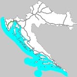
The Istrian Y is a highway
complex in the Croatian highway network
, consisting of section A8 Matulji-Kanfanar and section A9 Slovenia-Kanfanar-Pula. It is called the Istrian Y because it is shaped like the letter Y, with the three stretches all meeting at Kanfanar interchange
in south central Istria
. The complex was built and will be maintained by the company BINA Istra
until 2027. Both highways have a speed limit between 100 km/h (62 mph) and 80 km/h (50 mph).
in Primorje-Gorski Kotar County
and finishes in Kanfanar interchange
, at the crossing with the A9. The branch is built as a single carriageway limited-access road
, but the part between Kanfanar and Pazin
was projected as a dual carriageway
, so all the objects on the road are already prepared for a conversion to a motorway.
The most prominent feature of this branch of Istrian Y is the 5.4 km (3.4 mi) long Učka Tunnel
, the third longest tunnel in Croatia. The tunnel was opened in 1981 and is the main road that connects the Istrian peninsula
with Rijeka
and the rest of Croatia. The current toll
for the tunnel is 28 HRK
for passenger cars.
n-Slovenia
n border near Sečovlje
with the city of Pula
and services the tourist industry on the western coast of Istria. The sections between the border and Kanfanar are a single carriageway limited-access road
; from Kanfanar to Pula it is a dual carriageway
.
There are two prominent object on this branch of Istrian Y: the viaduct
"Limska draga" and the bridge
"Mirna". The bridge "Mirna" is currently being tolled.
The viaduct "Limska draga" was built between 1988 and 1991 and was the first part of the western branch of Istrian Y that was constructed. The bridge is 552 m long and the height of the highest pillon is 120 m.
The bridge "Mirna" was opened to traffic in 2005. The bridge represents the crossing over river Mirna
and was the most complicated object on the western branch of the Istrian Y because of the swampy terrain around the river. The bridge is 1355 m long and the height of the bridge at the highest point is 40 m. Currently the bridge is being tolled at the price of 14 HRK
for passenger cars.
The northern leg of the A9 motorway, 50 km from Umag
to Kanfanar
, was opened for traffic on 14 June 2011, eight months before the deadline.
The first phase, which was finished in 2007, involved the building of the two expressways, then called B8 and B9, in the two-lane freeway
form (single carriageway, one lane in each direction), except for the Kanfanar crossing, which was built as a four-lane highway from the start.
Because of the rise in traffic on the highway and because of safety issues, the second phase of construction commenced in October 2008. In this phase, the whole western branch of the Y, except the viaduct "Limska draga" and bridge "Mirna", were reconstructed as a four-lane highway by June 2011.
The eastern branch, from Kanfanar to Pazin, is also being reconstructed as a four-lane highway. This phase is supposed to be finished until June 2011.
After the second phase of the Y is going to be finished, the parts of the Y having four lanes are going to be tolled.
Currently there are no exact dates for the conversion of viaduct "Limska draga", bridge Mirna and the part of eastern branch of Y from Pazin to Matulji (including Učka Tunnel) to four lane highway.
The regulatory plan for the Istria County
calls for the connection of Labin
with the Y with a new expressway, which would connect to the Y in the vicinity of Žminj
.
Highway
A highway is any public road. In American English, the term is common and almost always designates major roads. In British English, the term designates any road open to the public. Any interconnected set of highways can be variously referred to as a "highway system", a "highway network", or a...
complex in the Croatian highway network
Highways in Croatia
Highways in Croatia are the main transport network in Croatia.The Croatian classification includes several classes of highways:* The main motorways are named A accompanied by one or two digits...
, consisting of section A8 Matulji-Kanfanar and section A9 Slovenia-Kanfanar-Pula. It is called the Istrian Y because it is shaped like the letter Y, with the three stretches all meeting at Kanfanar interchange
Kanfanar interchange
The Kanfanar interchange is a cloverleaf interchange west of Kanfanar, Croatia. The interchange represents the western terminus of the A8 motorway and it connects the A8 route to the A9 motorway representing major a link in the Croatian motorway system...
in south central Istria
Istria
Istria , formerly Histria , is the largest peninsula in the Adriatic Sea. The peninsula is located at the head of the Adriatic between the Gulf of Trieste and the Bay of Kvarner...
. The complex was built and will be maintained by the company BINA Istra
BINA Istra
BINA Istra is a Croatian joint stock company founded in 1995 to facilitate construction and subsequent management of a Istrian Y motorway, consisting of the A8 motorway and the A9 motorway. On September 21, 1995, BINA Istra has been granted concession regarding management of the Istrian Y...
until 2027. Both highways have a speed limit between 100 km/h (62 mph) and 80 km/h (50 mph).
Eastern branch
The A8 is a 64.21 km (39.9 mi) long branch which starts at MatuljiMatulji
Matulji is a municipality in Primorje-Gorski Kotar County, Croatia. It is located west of the Croatian town Rijeka, north of the town of Opatija, and it borders Slovenia...
in Primorje-Gorski Kotar County
Primorje-Gorski Kotar County
Primorje-Gorski kotar County is a county in western Croatia that includes the Bay of Kvarner and the surrounding Northern Croatian seacoast, and the mountainous region of Gorski kotar...
and finishes in Kanfanar interchange
Kanfanar interchange
The Kanfanar interchange is a cloverleaf interchange west of Kanfanar, Croatia. The interchange represents the western terminus of the A8 motorway and it connects the A8 route to the A9 motorway representing major a link in the Croatian motorway system...
, at the crossing with the A9. The branch is built as a single carriageway limited-access road
Limited-access road
A limited-access road known by various terms worldwide, including limited-access highway, dual-carriageway and expressway, is a highway or arterial road for high-speed traffic which has many or most characteristics of a controlled-access highway , including limited or no access to adjacent...
, but the part between Kanfanar and Pazin
Pazin
Pazin is the administrative seat of Istria County in Croatia. The town has a population of 4,986 , the total Pazin municipality population is 9,227...
was projected as a dual carriageway
Dual carriageway
A dual carriageway is a class of highway with two carriageways for traffic travelling in opposite directions separated by a central reservation...
, so all the objects on the road are already prepared for a conversion to a motorway.
The most prominent feature of this branch of Istrian Y is the 5.4 km (3.4 mi) long Učka Tunnel
Ucka Tunnel
The Učka Tunnel is a toll tunnel on the A8 motorway in Croatia. Being part of the Istrian Y network in Istria, it is wide and long, the third longest in Croatia after the Mala Kapela and Sveti Rok tunnels. The tunnel consists of a single tube, with two traffic lanes. Construction on the existing...
, the third longest tunnel in Croatia. The tunnel was opened in 1981 and is the main road that connects the Istrian peninsula
Istria
Istria , formerly Histria , is the largest peninsula in the Adriatic Sea. The peninsula is located at the head of the Adriatic between the Gulf of Trieste and the Bay of Kvarner...
with Rijeka
Rijeka
Rijeka is the principal seaport and the third largest city in Croatia . It is located on Kvarner Bay, an inlet of the Adriatic Sea and has a population of 128,735 inhabitants...
and the rest of Croatia. The current toll
Toll road
A toll road is a privately or publicly built road for which a driver pays a toll for use. Structures for which tolls are charged include toll bridges and toll tunnels. Non-toll roads are financed using other sources of revenue, most typically fuel tax or general tax funds...
for the tunnel is 28 HRK
Croatian kuna
The kuna is the currency of Croatia since 1994 . It is subdivided into 100 lipa. The kuna is issued by the Croatian National Bank and the coins are minted by the Croatian Monetary Institute....
for passenger cars.
Western branch
The A9 is a 76.79 km (47.72 mi) long branch which connects the CroatiaCroatia
Croatia , officially the Republic of Croatia , is a unitary democratic parliamentary republic in Europe at the crossroads of the Mitteleuropa, the Balkans, and the Mediterranean. Its capital and largest city is Zagreb. The country is divided into 20 counties and the city of Zagreb. Croatia covers ...
n-Slovenia
Slovenia
Slovenia , officially the Republic of Slovenia , is a country in Central and Southeastern Europe touching the Alps and bordering the Mediterranean. Slovenia borders Italy to the west, Croatia to the south and east, Hungary to the northeast, and Austria to the north, and also has a small portion of...
n border near Sečovlje
Secovlje
Sečovlje is a settlement in the Municipality of Piran in the Littoral region of Slovenia.-Overview:This is the last Slovenian settlement before the Slovenia-Croatia border. This village was once the centre of Slovenian salt production, now its main source of income is tourism at the Sečovlje...
with the city of Pula
Pula
Pula is the largest city in Istria County, Croatia, situated at the southern tip of the Istria peninsula, with a population of 62,080 .Like the rest of the region, it is known for its mild climate, smooth sea, and unspoiled nature. The city has a long tradition of winemaking, fishing,...
and services the tourist industry on the western coast of Istria. The sections between the border and Kanfanar are a single carriageway limited-access road
Limited-access road
A limited-access road known by various terms worldwide, including limited-access highway, dual-carriageway and expressway, is a highway or arterial road for high-speed traffic which has many or most characteristics of a controlled-access highway , including limited or no access to adjacent...
; from Kanfanar to Pula it is a dual carriageway
Dual carriageway
A dual carriageway is a class of highway with two carriageways for traffic travelling in opposite directions separated by a central reservation...
.
There are two prominent object on this branch of Istrian Y: the viaduct
Viaduct
A viaduct is a bridge composed of several small spans. The term viaduct is derived from the Latin via for road and ducere to lead something. However, the Ancient Romans did not use that term per se; it is a modern derivation from an analogy with aqueduct. Like the Roman aqueducts, many early...
"Limska draga" and the bridge
Bridge
A bridge is a structure built to span physical obstacles such as a body of water, valley, or road, for the purpose of providing passage over the obstacle...
"Mirna". The bridge "Mirna" is currently being tolled.
The viaduct "Limska draga" was built between 1988 and 1991 and was the first part of the western branch of Istrian Y that was constructed. The bridge is 552 m long and the height of the highest pillon is 120 m.
The bridge "Mirna" was opened to traffic in 2005. The bridge represents the crossing over river Mirna
Mirna River (Croatia)
The Mirna is a river in Istria, Croatia. It is Istria's longest and richest river, being long and having a basin covering an area of . It rises near Buzet, and empties into the Adriatic Sea near Novigrad.-External links:* *...
and was the most complicated object on the western branch of the Istrian Y because of the swampy terrain around the river. The bridge is 1355 m long and the height of the bridge at the highest point is 40 m. Currently the bridge is being tolled at the price of 14 HRK
Croatian kuna
The kuna is the currency of Croatia since 1994 . It is subdivided into 100 lipa. The kuna is issued by the Croatian National Bank and the coins are minted by the Croatian Monetary Institute....
for passenger cars.
The northern leg of the A9 motorway, 50 km from Umag
Umag
Umag is a coastal city in Istria, Croatia.The city hosts the yearly Croatia Open ATP tennis tournament on clay courts.-Geography:It is the westernmost city of Croatia, and the municipality includes Savudrija which is westernmost point of Croatia....
to Kanfanar
Kanfanar
Kanfanar is a municipality in the central part of Istria, Croatia, 20 km northeast of Rovinj, on the edge of the Lim Cove, on the open limestone plain of Istria. The elevation is 281 m.Chief occupations are farming and livestock breeding...
, was opened for traffic on 14 June 2011, eight months before the deadline.
Conversion to a highway and the future expansions
The Istrian Y highway is being built in two phases.The first phase, which was finished in 2007, involved the building of the two expressways, then called B8 and B9, in the two-lane freeway
Two-lane freeway
A two-lane expressway is an expressway with only one lane in each direction, and usually no median barrier. It may be built that way because of constraints, or may be intended for expansion once traffic volumes rise. The term super two is often used by roadgeeks for this type of road, but traffic...
form (single carriageway, one lane in each direction), except for the Kanfanar crossing, which was built as a four-lane highway from the start.
Because of the rise in traffic on the highway and because of safety issues, the second phase of construction commenced in October 2008. In this phase, the whole western branch of the Y, except the viaduct "Limska draga" and bridge "Mirna", were reconstructed as a four-lane highway by June 2011.
The eastern branch, from Kanfanar to Pazin, is also being reconstructed as a four-lane highway. This phase is supposed to be finished until June 2011.
After the second phase of the Y is going to be finished, the parts of the Y having four lanes are going to be tolled.
Currently there are no exact dates for the conversion of viaduct "Limska draga", bridge Mirna and the part of eastern branch of Y from Pazin to Matulji (including Učka Tunnel) to four lane highway.
The regulatory plan for the Istria County
Istria County
Istria County is the westernmost county of Croatia which includes the biggest part of the Istrian peninsula . The area of the county is called Istra in Croatian and Slovene...
calls for the connection of Labin
Labin
Labin is a town in Istria, Croatia, with a town population of 6,884 and 11,703 in the greater municipality ....
with the Y with a new expressway, which would connect to the Y in the vicinity of Žminj
Žminj
Žminj , a municipality in the central part of Istria , 15 km south of Pazin; elevation 355 m; population 3.447. It was first mentioned in 1177 as a parish of the Poreč diocese....
.