
.gif)
A1 (Croatia)
Encyclopedia
The A1 motorway is the longest motorway in Croatia
spanning 465.5 kilometres (289.2 mi). As it connects Zagreb
, the nation's capital, to Split
, the second largest city in the country and the largest city in Dalmatia
, the motorway represents a major north–south transportation corridor in Croatia and a significant part of the Adriatic–Ionian motorway. Apart from Zagreb and Split, the A1 motorway runs near a number of major Croatian cities, provides either access to several national parks or nature parks
, world heritage sites
, and numerous resorts, especially along the Adriatic Coast. The motorway is currently being extended south of Split to the Port of Ploče
and the city of Dubrovnik
. National significance of the motorway is reflected through its positive economic impact
on the cities and towns it connects as well as its importance to tourism in Croatia
, however its genuine importance as a transit route shall be achieved upon completion of the Adriatic–Ionian motorway along the sections currently spanned just by the Adriatic Highway and two-lane roads in Slovenia
and Albania
connecting to the route.
The motorway consists of two traffic lanes and an emergency lane in each driving direction separated by a central reservation
. All intersections of the A1 motorway are grade separated
. As the route traverses rugged mountainous and coastal terrain the route completed as of August 2011 required 361 bridge
s, viaduct
s, tunnel
s and other similar structures, including the two longest tunnels in Croatia and two bridges comprising spans of 200 metres (656.2 ft) or more. Currently there are 32 exits and 26 rest area
s operating along the route. As the motorway is tolled
using a ticket system
and vehicle classification in Croatia
, each exit includes a toll plaza.
A motorway connecting Zagreb and Split was originally designed in the early 1970s, and a public loan was started in order to collect sufficient funds for its construction. However, due to political upheavals in Croatia
and Yugoslavia
, construction of the motorway was labeled a "nationalist project" and cancelled in 1971. After Croatian independence
and conclusion of the Croatian War of Independence
, efforts to build the motorway were renewed and construction started in 2000. The Zagreb–Split section of the route was completed by 2005, while the first sections between Split and Dubrovnik opened in 2007 and 2008. Construction costs incurred so far amount to 3 billion euro
. The figure includes funds approved for construction work scheduled to be completed by 2013. On the other hand the amount does not include construction cost related to Lučko–Bosiljevo 2 section since that section was funded as a part of Rijeka–Zagreb motorway construction project through Autocesta Rijeka–Zagreb, current operator of that sector. The remainder of the A1 motorway, i.e., the sections south of the Bosiljevo 2 interchange are operated by Hrvatske autoceste.
connecting the capital of the country, Zagreb
, to the Dalmatia
region, where the motorway follows a route parallel to the Adriatic
coast. As a part of the road network of Croatia
, it is a part of two major European routes
: E65
Prague
–Bratislava
–Zagreb–Rijeka
–Split
–Dubrovnik
and E71
Budapest
–Zagreb–Karlovac
–Bihać
–Knin
–Split. The motorway is of major importance to Croatia in terms of development of the economy
; especially tourism
and as a transit transport route. This has been reflected by an accelerated development of regions connected by the A1 motorway. A part of the motorway is considered to be a segment of the Adriatic–Ionian motorway.
The motorway currently spans 465.5 kilometres (289.2 mi) between Zagreb (Lučko interchange
) and Vrgorac
near Ploče
via Split. The route serves Karlovac via D1
, Gospić
via D534
, Zadar
via D8
and D424 and Šibenik
via D533
. It is scheduled to extend to Ploče by around the end of 2012. The A1 motorway consists of two traffic lanes and an emergency lane
in each driving direction along its entire length. The sole exception is Drežnik Viaduct
where there are no emergency lanes. Almost all of the existing interchanges are trumpet interchanges, except for Lučko which is a stack
. There are numerous rest area
s along the motorway, providing various types of services ranging from simple parking spaces and restrooms to petrol stations, restaurants and hotels. As of June 2011, the motorway has 31 interchanges, providing access to numerous towns and cities and the Croatian state road network. The ultimate southern terminus of the motorway has been established to be near Dubrovnik.
Between the Lučko and Bosiljevo 2
interchanges, the motorway follows Pan-European corridor Vb
, and is concurrent
with the Zagreb–Rijeka motorway. The Bosiljevo 2 interchange distributes southbound A1 traffic flowing to Rijeka
(via the A6 motorway
) and to Split. That 67 kilometres (41.6 mi) segment of the motorway is operated by Autocesta Rijeka–Zagreb, while the remainder of the motorway is operated by Hrvatske autoceste.
An automatic traffic monitoring and guidance system is in place along the motorway. It consists of measuring, control and signaling devices, located in zones where driving conditions may vary—at interchanges, near viaducts, bridges, tunnels, and in zones where fog and strong wind are known to occur. The system comprises variable traffic signs used to communicate changing driving conditions, possible restrictions and other information to motorway users.
The motorway route offers a scenic ride through rolling hills in the north, mountains in its central section, and along the Dalmatian coast in the south. It serves, either directly or via connecting roads, a large number of tourist destinations such as Bjelolasica in Gorski Kotar
, a large number of Adriatic Sea
resorts and several national parks and nature parks
. In Lika region those are Plitvice Lakes National Park, Sjeverni Velebit National Park and Velebit
Nature Park, while in Dalmatia the motorway serves Paklenica
National Park, Telašćica
Nature Park, Kornati
National Park, Lake Vrana Nature Park, Krka National Park
and Biokovo
Nature Park. The route also provides links to a number of UNESCO
World Heritage Site
s such as Plitvice Lakes
, Cathedral of St. James in Šibenik
, Palace of Diocletian in Split and the Historic City of Trogir
.
based on the vehicle classification in Croatia
using a closed toll system integrated with the A6 motorway as the two connect in the Bosiljevo 2 interchange forming a unified toll system. Since the two motorways are operated by Autocesta Rijeka — Zagreb and Hrvatske autoceste, the toll collection system is operated jointly by the two operators. The toll is payable in Croatian kuna
, euro
, major credit and debit cards and using a number of prepaid toll collection systems including various types of smart cards issued by the motorway operators and ENC – an electronic toll collection (ETC)
which is shared at all motorways in Croatia (except the A2 motorway
) and provides drivers use of dedicated lanes at toll plazas and a discounted toll rates.
The A1 north of the Bosiljevo 2 interchange is operated by Autocesta Rijeka — Zagreb and the rest is operated by Hrvatske autoceste, both of which do not report company toll income separately for individual sections of various motorways. Total toll income reported by Hrvatske atuoceste in the first half of 2011 was 508.1 million kuna (68.3 million euro). This figure pertains to the A1 south of the Bosiljevo 2 interchange as well as all other motorways operated by Hrvatske autoceste, however the A1 represents the longest and the busiest tolled motorway operated by Hrvatske autoceste. Toll income reported by Autocesta Rijeka — Zagreb for the first half of 2011 is 191.2 million kuna (25.7 million euro). This sum includes company toll income generated elsewhere, however the A1 section represents the busiest section of the motorway network operated by Autocesta Rijeka — Zagreb. Hrvatske autoceste and Autocesta Rijeka — Zagreb reported increase of the toll income compared to the same period of 2010 of 2.2% and 5% respectively.
Summertime and holiday queues at Lučko mainline toll plaza can be considerable, a problem exacerbated during the usual weekend-to-weekend tourist stays at Croatia's coastal resorts. In 2009, in an effort to address the problem, the Lučko mainline toll plaza was expanded to 15 lanes, and a single additional 10-lane toll plaza was built for fast cashless toll collection in Demerje
. The Demerje toll plaza is available via a motorway fork accessible to the A1 northbound traffic only. Vehicles using the Demerje toll plaza default to the original motorway route immediately past the Lučko mainline toll plaza, between the plaza and the Lučko interchange. The faster cashless system has raised the nominal capacity of the road from 2,325 to 11,150 vehicles per hour. As of September 2010 northbound traffic leaving the A1 must exit the tolled motorway network, since the existing Zagreb bypass
is not tolled, and then re-enter another tolled motorway. There are plans for the outer Zagreb bypass to be integrated into the tolled motorway network, as the ultimate solution for congestion at the Lučko toll plaza. That will require construction of a Horvati
interchange south of the Lučko toll plaza.
s, and tunnels—have been completed on the motorway between Zagreb and Vrgorac, and calculations indicate that 18.6 percent of the route between Zagreb and Split is located on those structures, which is a quite considerable percentage for a motorway of this length. By June 2011, Ravča-Vrgorac section was completed, including 5 viaducts, 4 flyovers and a tunnel.
As of September 2010, there are seven tunnels longer than 1000 metres (3,280.8 ft) on the A1 motorway. The most notable among them are: the 5821 metres (19,097.8 ft) long Mala Kapela Tunnel
between Ogulin and Brinje interchanges and the 5768 metres (18,923.9 ft) long Sveti Rok Tunnel
between Sveti Rok and Maslenica interchanges. The Mala Kapela and Sveti Rok tunnels are not only the largest individual structures on the motorway but they are also the longest tunnels in Croatia. The tunnels separate three distinct climate zones. The Mala Kapela Tunnel spans between the continental climate
of the central Croatia and the mountain climate of Lika, while the Sveti Rok Tunnel provides a link between Lika and its mountain climate and the Mediterranean climate
of Dalmatia. Both of the Mala Kapela and Sveti Rok tunnels were originally operated as single tubes when they were opened for traffic in June 2005 until May 30, 2009, when the second tubes of the tunnels were also opened for traffic. The other major tunnels on the A1 motorway are the 2300 metres (7,545.9 ft) long Plasina Tunnel
situated between Otočac and Perušić interchanges and the Grič
, Brinje
and Konjsko
tunnels. Lengths of the latter three range between 1122 metres (3,681.1 ft) and 1542 metres (5,059.1 ft).
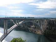 The longest bridge on the A1 motorway is the 546 metres (1,791.3 ft) long Dobra Bridge
spanning Dobra River near Karlovac. Other major bridges on the route are the Gacka
, Miljanica and Dabar
bridges—all of them longer than 350 metres (1,148.3 ft). Also, the A1 motorway comprises the 391 metres (1,282.8 ft) long Krka Bridge
spanning Krka River
and the 378 metres (1,240.2 ft) long Maslenica Bridge
spanning Novsko Ždrilo strait. The Maslenica and Krka bridges are particularly significant as their respective main spans are 200 m (656.2 ft) long.
The A1 motorway also comprises the longest viaduct in Croatia — the 2485 metres (8,152.9 ft) long Drežnik Viaduct
situated between the Karlovac and Bosiljevo 1 interchanges. As of June 2011, there are six other major viaducts completed on the route–— the Kotezi Viaduct
, Modruš 1, Mokro Polje, Jezerane
, Srijane
and Rašćane
viaducts. All of them are longer than 500 metres (1,640.4 ft). The latest significant viaduct completed as a part of Ravča–Vrgorac
section is Kotezi Viaduct at 1214 metres (3,982.9 ft) surpassing all other viaducts on the route, except for Drežnik Viaduct. A dispute concerning naming of the Viaduct arose one month prior to opening of the motorway section containing the viaduct, and the structure was even signposted as the Bunina Viaduct for several days in June 2011, only to revert the name to the Kotezi Viaduct days prior to the opening ceremony itself. The section also comprises the 402 metres (1,318.9 ft) long Šare Viaduct
.
and removal of the Croatian leadership that proposed and adopted the construction plan in 1971, all the work related to the Zagreb–Split motorway was cancelled. The plans were revived in the 1990s and new designs were developed to include a motorway section built between Zagreb and Karlovac into the design so that the section could be shared between Zagreb–Split and Zagreb–Rijeka motorways. Construction work started in 2000 and the motorway reached Split by 2005 and was extended towards Dubrovnik later on. Both in the 1970s and in 2000s, construction of the Zagreb–Split motorway was perceived to symbolize rebuilding of national unity.
on March 5, 1971, as priority transport routes of Croatia
that were to be developed as motorways. Originally the motorway was designed to follow a route from Zagreb to Bihać
(Bosnia and Herzegovina
) and then to Split via Knin
. The government of Bosnia and Herzegovina issued its approval for the route in Bihać region in the same year. Construction of the motorway was initiated by a fundraising effort — a public loan. The funds gathered initially through the public loan were sufficient for construction of 20 kilometres (12.4 mi) of the motorway.
The 39.3 kilometres (24.4 mi) long Zagreb–Karlovac section of the Zagreb–Rijeka motorway, now part of the A1 motorway, was completed in 1972. Further construction of motorways from Zagreb to Rijeka and Split was suspended for the next 28 years following a political decision of the Croatian leadership, newly installed during Yugoslav suppression of the Croatian Spring, to "stop megalomaniac projects". It is considered that the true reason for the cancellation of the works was that the motorway was considered to be a "nationalist" project. The conclusion is supported by the fact the road was spontaneously nicknamed King Tomislav Motorway by citizens investing their money through the public loan after the first king of medieval Croatia
, who united Croatia as a single kingdom in 925. The funds raised through the public loan were left unused for several months, then spent for construction of a road between Vrlika
and Strmica via Knin, currently a part of the D1 and D30
state roads. However, the United Nations Economic Commission for Europe
recognized the route as the southernmost part of the Pyhrn route, giving it the designation E59
in 1975. Subsequent reorganizations of the E-road network, including the latest one in 2008, transferred the route south of Zagreb to the E71.
. The decade saw renewed discussion regarding construction of the motorway, including renewed considerations of its route. Soon, the originally devised route running through Bihać was set aside and two new routes were considered: One of them was a modified version of the original route, bypassing Bihać and running through the Plitvice Lakes region while the other was a completely new route further to the west via Gospić and Zadar, which was eventually accepted for construction. Both of the alternative routes proposed that the Zagreb–Karlovac motorway already completed in 1972 were to be used as the northernmost section of the Zagreb–Split and Zagreb–Rijeka motorways.
The A1 was a showpiece project of the Croatian government and a symbol of uniting the country. The first attempt to revive the project in earnest occurred in the 1993, when the excavation of Sveti Rok Tunnel began. More comprehensive construction work started in 2000 and Karlovac–Vukova Gorica
section opened in 2001. In 2003, the first sections not shared with the Zagreb–Rijeka Motorway were completed: Vukova Gorica–Mala Kapela Tunnel and Gornja Ploča–Zadar 2. Mala Kapela Tunnel–Gornja Ploča, Zadar 2–Pirovac and Vrpolje–Dugopolje sections opened in 2004 and Mala Kapela Tunnel itself and Pirovac–Vrpolje section opened in 2005 marking completion of the Zagreb–Split Motorway, culminating with the grand opening of Karlovac — Split section on June 26, 2005.
Construction of the motorway along its Split–Dubrovnik sector started once the motorway sectors north of Split were complete, and the section between Split (Dugopolje interchange) and Šestanovac
interchange opened on June 27, 2007. The last sections to be completed to date are Šestanovac–Ravča, opened on December 22, 2008, and Ravča-Vrgorac section opened on June 30, 2011. In the 2000s, as the motorway construction works were gradually progressing further south, the motorway earned its unofficial, yet widely used name—Dalmatina in Croatian press because it connected Zagreb to Dalmatia
. In 2010, Donja Zdenčina interchange was opened between Lučko and Jastrebarsko interchanges.
s (approximately 12.65 billion kuna at the time, or approximately 1.533 billion euro
s). In 2010, Hrvatske autoceste reported that the average cost of one kilometer of Bosiljevo–Split motorway was 7.1 million euro, which would mean that the total construction cost was 2.21 billion euro for that 311.4 kilometres (193.5 mi) long segment.
Construction cost incurred on the Dugopolje–Ploče sector of the motorway between 2005 and 2008 was reported at 4.1 billion kuna and additional 1.8 billion kuna of construction expenses are planned until the end of 2012 (representing approximately 560 and 245 million euro, respectively). The latter figure includes construction of the D425 state road
but it does not include full completion of the Vrgorac–Ploče section.
, which caused a significant alteration of the A1 route near Vrgorac as well as a complete revamp of the A10
. At this time the section to Ploče is expected to be complete by 2012 or March 2013 at the latest. As of November 2010, one new interchange is under construction on the existing A1 sections—Novigrad interchange which is planned to provide access to the D6 state road
, Netretić
and Jurovski Brod
border crossing to Slovenia
and planned to be completed in November 2011,
At some point after 2012, the A7 motorway is planned to be completed between Rijeka and Žuta Lokva (near Brinje
), and a directional T interchange
shall replace the trumpet interchange built at Žuta Lokva. The new interchange shall not feature any weaving, similar to the Bosiljevo 2 interchange of the A1 and A6 motorways.
Hrvatske autoceste, operator of the southern portion of the A1 motorway, ordered the execution of design documents, feasibility and environmental impact studies for the Doli – Osojnik
section of the motorway that is to be constructed near Dubrovnik. Commencement of construction on this section was originally scheduled for 2009. Despite an official ceremony to mark commencement of construction works on the section, no works beyond design and study development has been carried out there. Ploče–Metković and Metković–Opuzen sections are currently in design development stage and the planned Metković interchange is designed to serve as the A1 junction to the A10 motorway
. Construction of the Ploče–Metković, Metković–Opuzen and Doli–Osojnik sections is not planned to start before 2012 as no funds are planned for that purpose by the road construction plan of the Republic of Croatia.
The A1 motorway route between Ploče and Doli has not been fixed yet, as several options exist, all of which require the route to cross either a section of the Adriatic Sea or a part of the territory of Bosnia and Herzegovina. Croatia is guaranteed passage through municipality of Neum in Bosnia and Herzegovina by Neum Agreement
, however the agreement still provides for some restrictions regarding transit of goods banned for import in Bosnia and Herzegovina and says nothing on an actual transit route apart that vehicles using it must travel from Croatian territory near Ploče to Croatian territory around Dubrovnik. However since, as of June 2011, no agreement regarding the motorway route was reached between Croatia and Bosnia and Herzegovina it is unclear whether the motorway shall re-enter Croatian territory around Dubrovnik. An alternate route proposed comprises the Pelješac Bridge
and a section to Doli, west of Dubrovnik. It was suggested by the Croatian government that this route shall be required to permit Croatia to join Schengen Area
as transit through Neum would present an obstacle in that respect, as for instance, live animals would have to be ferried to Pelješac
to avoid transit outside the Schengen Area. The claim was later commented by the European Commission
, which said that the bridge need not be built, but its completion would simplify situation regarding EU accession. As of June 2011, Croatia is implementing projects and reforms required to join the Schengen Area by 2015.
, and 53,216 vehicle average summer daily traffic (ASDT) figures as that is the section closest to Zagreb. South of the Bosiljevo 2 interchange the first major drop of traffic volume is recorded on the A1 motorway, due to traffic transferring to the A6 motorway towards Rijeka. Other similar changes of the traffic volume are registered near Zadar (served by Zadar 1 and Zadar 2 interchanges) and Split served by Dugopolje interchange. Substantial variations observed between AADT and ASDT are normally attributed to the fact that the motorway carries significant tourist traffic. The seasonal increase traffic volume variations ranges 69% on the busiest, Lučko–Jastrebarsko section to 160% as measured on Sveti Rok–Maslenica section. The summer season traffic volume increase on the motorway is 120%.
 As of September 2010, there are 26 rest areas operating along the A1 motorway, and additional rest areas are planned along the existing sections of the route and those sections currently under construction. Legislation provides for four types of rest areas designated as types A through D—A-type rest areas comprise a full range of amenities including a filling station
, a restaurant
and a hotel
or a motel
; B-type rest areas have no lodging; C-type rest areas are very common and include a filling station and a café
, but no restaurants or accommodation; D-type rest areas offer parking spaces only, possibly some picnicking tables and benches and restrooms. Even though the rest areas found along the A1 motorway generally follow this ranking system, there are considerable variations as some of them offer extra services. The most notable example is Krka rest area—even though it has no filling station, there is, for instance, a restaurant available. The filling stations regularly have small convenience stores and some of them offer LPG fuel. EuroTest, an international association of 18 European automobile clubs spearheaded by German automobile club ADAC
, surveyed three of the A1 motorway rest areas in 2009: Krka, Lički Osik and Modruš (in case of the latter, both eastbound and westbound). All of the rest areas were rated as very good, especially in terms of facilities offered.
The primary motorway operators Hrvatske autoceste (HAC) and Autocesta Rijeka – Zagreb lease the A, B and C type rest areas to various operators through public tenders. As of September 2010, there are five such rest area operators on the A1 motorway: INA, OMV
, Tifon, Petrol
and Crobenz. The rest area operators are not permitted to sub-lease the fuel operations; Tifon and Petrol operated rest areas have restaurants or hotels operated by Marché, a Mövenpick Hotels & Resorts
subsidiary. All of the A1 motorway rest areas, except Stupnik and Jezerane, are accessible to both directions of the motorway traffic. The rest areas normally operate 24 hours a day, 7 days a week.
{| class="wikitable"
|+ List of A1 motorway rest areas
|-
!scope="col"|County
!scope="col"|km
!scope="col"|Name
!scope="col"|Operators
!scope="col"|Notes
|-
| City of Zagreb
| style="background:#fdd;"|1.1
| style="background:#fdd;"|Stupnik
| style="background:#fdd;"|OMV
| style="background:#fdd;"|Facilities found at Stupnik rest area comprise a filling station selling petrol, diesel fuel and LPG, a café and restrooms.
Accessible to the southbound traffic only
|-
| Zagreb County
| 16.9
| Desinec
| Petrol
Marché
| Facilities found at Desinec rest area comprise a filling station selling petrol, diesel fuel and LPG, a restaurant, a motel, an ATM
and restrooms. The motel is operated by Marché.
|-
| rowspan=4|Karlovac
| 33.6
| Draganić
| Tifon
Marché
| Facilities found at Desinec rest area comprise a filling station selling petrol, diesel fuel and LPG, a restaurant, a hotel and restrooms. The hotel and the restaurant are operated by Marché and are accessible to the southbound traffic only.
|-
|
|
| INA
| Facilities found at Vukova Gorica rest area comprise a filling station selling petrol, diesel fuel and LPG, a restaurant, a motel and restrooms.
|-
| 78.4
| Dobra
| Tifon
Marché
| Facilities found at Dobra rest area comprise a filling station selling petrol, diesel fuel and LPG, a restaurant, an ATM, showers and restrooms. The hotel and the restaurant are operated by Marché.
|-
| 100.6
| Modruš
| HAC
| Facilities found at Modruš rest area comprise picnicking tables and restrooms.
|-
| rowspan=8 |Lika‑Senj
| style="background:#fdd;"|109.2
| style="background:#fdd;"|Jezerane
| style="background:#fdd;"|HAC
| style="background:#fdd;"|Facilities found at Jezerane rest area comprise picnicking tables and restrooms.
Accessible to the southbound traffic only
|-
| 119.0
| Brinje
| INA
| Facilities found at Brinje rest area comprise a filling station selling petrol and diesel fuel, a café and restrooms.
|-
| 134.1
|
| HAC
| Parking area only
|-
| 152.9
|
| HAC
| Parking area only
|-
| 159.8
| Janjče
| OMV
| Facilities found at Janjče rest area comprise a filling station selling petrol and diesel fuel, a restaurant, a café and restrooms.
|-
| 175.0
|
| HAC
| Facilities found at Lički Osik rest area comprise picnicking tables and restrooms.
|-
| 191.5
| Jadova
| HAC
| Parking area only
|-
| 201.1
| Zir
| INA
Macola
| Facilities found at Zir rest area comprise a filling station selling petrol, diesel fuel and LPG, a café and restrooms. The facilities additionally available to the southbound traffic only are a restaurant and a motel.
|-
| rowspan=4 |Zadar
| 227.9
| Marune
| HAC
Mataš
| Facilities found at Marune rest area comprise a four star hotel, a café, a convenience store, picnicking tables and restrooms.
|-
| 239.4
| Jasenice
| Tifon
Marché
| Facilities found at Desinec rest area comprise a filling station selling petrol, diesel fuel and LPG, a restaurant, showers and restrooms. The restaurant is operated by Marché.
|-
| 271.0
| Nadin
| OMV
| Facilities found at Nadin rest area comprise a filling station selling petrol and diesel fuel, a restaurant, a café and restrooms.
|-
| 292.0
| Pristeg
| HAC
| Parking area only
|-
| rowspan=3 |Šibenik‑Knin
| 306.6
| Prokljan
| INA
| Facilities found at Prokljan rest area comprise a filling station selling petrol and diesel fuel, a café and restrooms.
|-
| 315.0
| Krka
| HAC
| Facilities found at Krka rest area comprise an a la carte
restaurant, a café, a convenience store, picnicking tables and restrooms.
|-
| 332.0
| Vrpolje
| Crobenz
| Facilities found at Vrpolje rest area comprise a filling station selling petrol and diesel fuel, a restaurant, a café, an ATM and restrooms.
|-
| rowspan=5 |Split‑Dalmatia
| 343.5
| Sitno
| HAC
| Parking area only
|-
| 356.3
| Radošić
| HAC
| Parking area only; Accessible to both southbound and northbound traffic
|-
| 369.6
| Kozjak
| INA
| Facilities found at Kozjak rest area comprise a filling station selling petrol, diesel fuel and LPG, a café and restrooms.
|-
| 392.6
| Mosor
| Petrol
| Facilities found at Mosor rest area comprise a filling station selling petrol and diesel fuel, a café and restrooms.
|-
|
|
| HAC
| Facilities found at Rašćane Gornje rest area comprise parking areas and restrooms only.
|-
!scope="col"|County
!scope="col"|km
!scope="col"|Exit
!scope="col"|Name
!scope="col"|Destination
!scope="col"|Notes
|-
| rowspan=4|City of Zagreb
| style="background:#dfd;"|0.0
| style="background:#dfd; text-align:center;"| 1
| style="background:#dfd;" | Lučko
| style="background:#dfd;"|
| style="background:#dfd;"|Access to the A3 motorway
– Zagreb bypass
(E70), the A2
and A4
motorways and the city of Zagreb
itself via Jadranska Avenue (Ž1040)
; Northbound A1 traffic defaults to six-lane Jadranska Avenue (Ž1040)
The northern terminus of European routes E65/E71 concurrency; The northern terminus of the motorway
Five level stack interchange
, contains two loop ramps, but it still has five levels (including an exit serving Lučko
via Puškarićeva street)
|-
| 0.6
| align=center | | colspan=2|Lučko toll plaza
| Lučko mainline toll plaza, serving both southbound and northbound traffic; The plaza accepts cash only, while drivers using ETC or credit/debit card payment methods must exit the motorway via Demerje toll plaza.
|-
| style="background:#fdd;"|1.1
| style="background:#fdd; text-align:center;"| | style="background:#fdd;" colspan="2"|Stupnik rest area
| style="background:#fdd;"|Accessible to the southbound traffic only
|-
| style="background:#fdd;"|3.6
| style="background:#fdd; text-align:center;"|
| style="background:#fdd;" colspan="2"|Demerje
toll plaza
| style="background:#fdd;"|Demerje mainline toll plaza access fork, accessible to northbound traffic only; The plaza accepts cashless payments only, while drivers using cash payment methods must exit the motorway via Lučko toll plaza. The traffic using this exit proceeds north along a three lane access road parallel to the main A1 route and rejoins it immediately to the north of Lučko toll plaza. There are no other exits available along the access road.
|-
| rowspan=3|Zagreb County
| 14.2
| align=center | 1a
|
|
| Connection to Klinča Sela
The D36 state road
is planned to be rerouted to this interchange.
|-
| 16.9
| align=center |
| colspan= 3 |Desinec rest area
|-
| 20.0
| align=center | 2
| |Jastrebarsko
|
| Trumpet interchange providing access to Jastrebarsko
|-
| rowspan=13|Karlovac
| 33.6
| align=center |
| colspan= 3 |Draganić
|-
| style="background:#dfd;"|38.6
| style="background:#dfd; text-align:center;"| 3
| style="background:#dfd;"|Karlovac
| style="background:#dfd;"|
| style="background:#dfd;"|Access to Karlovac via the D1/D3 (E71 concurrent at the junction); Access to Plitvice Lakes National Park.
An at-grade intersection is located just outside the toll plaza providing access to the D36 state road.
The southern terminus of the European route E71 concurrency.
|-
|
| colspan="4" style="text-align:center;"|Drežnik Viaduct
|-
|
| colspan="4" style="text-align:center;"|Dobra Bridge
|-
| style="background:#ffdead;"|50.0
| style="background:#ffdead; text-align:center;"| 4
| style="background:#ffdead;"|Novigrad
| style="background:#ffdead;"|
| style="background:#ffdead;"|Access to Netretić
and Jurovski Brod
border crossing to Slovenia
Interchange under construction – planned to open in November 2011
|-
| 62.9
| align=center | 5
| Bosiljevo 1
|
| Access to Bosiljevo, Bosanci (D3
) and Pribanjci
border crossing to Slovenia
|-
|
| align=center |
| colspan= 3 |Vukova Gorica rest area
|-
| style="background:#dfd;"|66.8
| style="background:#dfd; text-align:center;"| 6
| style="background:#dfd;"|Bosiljevo 2
| style="background:#dfd;"|
| style="background:#dfd;"|Limited access trumpet interchange, providing access to the A6 motorway (E65) to Rijeka
The first intermediate terminus of the European route E65 concurrency—the route north of this interchange is concurrent with the E65.
|-
| 78.4
| align=center |
| colspan= 3 |Dobra rest area
|-
| 86.8
| align=center | 7
| Ogulin
|
| Connection to Ogulin, Oštarije
and Josipdol
, Klek Mountain and Bjelolasica sports centre
|-
|
| colspan="4" style="text-align:center;"|Miljanica Bridge
|-
|
| colspan="4" style="text-align:center;"|Modruš 1 Viaduct
|-
| 100.6
| align=center |
| colspan= 3 |Modruš rest area
|-
| Karlovac
/
Lika‑Senj
|
| colspan="4" style="text-align:center;"|Mala Kapela Tunnel
|-
| rowspan=21 |Lika‑Senj
| style="background:#fdd;"|109.2
| style="background:#fdd; text-align:center;"|
| style="background:#fdd;" colspan="2"|Jezerane rest area
| style="background:#fdd;"|Accessible to the southbound traffic only
|-
|
| colspan="4" style="text-align:center;"|Mokro Polje Viaduct
|-
|
| colspan="4" style="text-align:center;"|Jezerane Viaduct
|-
| 115.2
| align=center | 8
| Brinje
|
| Connection to Brinje and Križpolje
|-
| 119.0
| align=center |
| colspan= 3 |Brinje rest area
|-
|
| colspan="4" style="text-align:center;"|Brinje Tunnel
|-
| style="background:#dfd;"|124.9
| style="background:#dfd;" align=center | 9
| style="background:#dfd;" nowrap=yes|Žuta Lokva
| style="background:#dfd;"|
| style="background:#dfd;"|A very short stretch of the A7 is currently in place at this interchange. Motorway exit (and present A7 section) terminates in a junction with the D23 after approximately 1 kilometre (0.621372736649807 mi), just 300 metres (984.3 ft) to the north of junction of the D23 and D50
state roads. Provides connection to Senj
, the D8
state road and island of Rab
(to the west)
The second intermediate terminus of the European route E65 concurrency—the route south of this interchange is concurrent with the E65.
|-
| 134.1
| align=center |
| colspan= 3 |Brloška Dubrava rest area
|-
| 137.8
| align=center | 10
| Otočac
|
| Connection to Otočac, Plitvice Lakes National Park, Sjeverni Velebit National Park and Velebit
Nature Park
|-
|
| colspan="4" style="text-align:center;"|Gacka Bridge
|-
|
| colspan="4" style="text-align:center;"|Plasina Tunnel
|-
|
| colspan="4" style="text-align:center;"|Grič Tunnel
|-
| 152.9
| align=center |
| colspan= 3 | Ličko Lešće rest area
|-
| 159.8
| align=center |
| colspan= 3 |Janjče rest area
|-
| 169.7
| align=center | 11
| Perušić
|
| Connection to Perušić (D50
)
|-
| 175.0
| align=center |
| colspan= 3 |Lički Osik rest area
|-
| 181.0
| align=center | 12
| Gospić
|
| Provides access to Gospić, Lički Osik
, Karlobag
and Korenica
via the D25
and D50
state roads
|-
| 191.5
| align=center |
| colspan= 3 |Jadova rest area
|-
| 201.1
| align=center |
| colspan= 3 |Zir rest area
|-
| 204.0
| align=center | 13
|
|
| Connection to Udbina
(D1
) and Plitvice Lakes National Park
|-
| 209.6
| align=center | 14
| Sveti Rok
|
| Connection to Gračac
and Medak
|-
| Lika‑Senj
/ Zadar
|
| colspan="4" style="text-align:center;"|Sveti Rok Tunnel
|-
| rowspan=10 |Zadar
| 227.9
| align=center |
| colspan= 3 |Marune rest area
|-
| 239.4
| align=center |
| colspan= 3 |Jasenice rest area
|-
| 242.4
| text-align:center;"| 15
| Maslenica
|
| Connection to Starigrad, Karlobag
, Posedarje
, Obrovac and Paklenica
National Park
|-
|
| colspan="4" style="text-align:center;"|Maslenica Bridge
|-
| 249.6
| align=center | 16
| Posedarje
|
| Connection to Pag Island
and Posedarje (D8)
|-
| 253.4
| align=center | 17
| Zadar 1
|
| Access to Zadar (north) via Zagrebačka street; Also serving Nin
, Vir
and Silba
|-
| 262.4
| align=center | 18
| Zadar 2
|
| Connection to Zadar (south), Zadar Airport
and Port of Zadar (Gaženica
); Also serving Ugljan
, Pašman
, Žut
, Dugi otok
, Telašćica
Nature Park and Sukošan
|-
| 271.0
| align=center |
| colspan= 3 |Nadin rest area
|-
| 278.7
| align=center | 19
| Benkovac
|
| Connection to Biograd na moru
, Benkovac, Kornati
National Park, Lake Vrana Nature Park, Sveti Filip i Jakov
and Pakoštane
; A motorway interchange connector road links both to the D27 and D503 roads.
|-
| 292.0
| align=center |
| colspan= 3 |Pristeg rest area
|-
| rowspan=9 |Šibenik‑Knin
| 300.1
| align=center | 20
| Pirovac
|
| Connection to Vodice
, Kornati National Park, Pirovac and Murter
Island
|-
| 306.6
| align=center |
| colspan= 3 |Prokljan rest area
|-
| 310.1
| align=center | 21
| Skradin
|
| Connection to Krka National Park
, Skradin, Visovac Island
and to Piramatovci (D59
) to the north
|-
|
| colspan="4" style="text-align:center;"|Krka Bridge
|-
| 315.0
| align=center |
| colspan= 3 |Krka rest area
|-
| 319.1
| align=center | 22
| Šibenik
|
| A connection to Šibenik
(D8
) to the south and Drniš
and Knin
to the north; Also serving Prvić
, Zlarin
, Žirje
, Kaprije and Obonjan islands
|-
|
| colspan="4" style="text-align:center;"|Dabar Bridge
|-
| 332.0
| align=center |
| colspan= 3 |Vrpolje rest area
|-
| 333.7
| align=center | 23
| Vrpolje
|
| Connection to Primošten
and Perković
|-
| rowspan=20 |Split‑Dalmatia
| 343.5
| align=center |
| colspan= 3 |Sitno rest area
|-
| 351.0
| align=center | 24
| Prgomet
|
| Connection to D8
at Plano (via Ž6091) and D58
near Prapatnice; The former facilitates a western approach to Kaštela
.
|-
| 356.3
| align=center |
| colspan= 3 |Radošić rest area
|-
| 364.7
| align=center | 24a
| Vučevica
|
| Serving Vučevica
|-
| 369.6
| align=center |
| colspan= 3 |Kozjak rest area
|-
|
| colspan="4" style="text-align:center;"|Konjsko Tunnel
|-
| 378.4
| align=center | 25
| Dugopolje
|
| The main entrance to Split
, via the D1 (E71) executed as an expressway, provides access to Split city centre and the D8
state route
|-
| 385.3
| align=center | 26
| Bisko
|
| Connection to Imotski
(via D60
), Trilj
and Kamensko border crossing to Bosnia and Herzegovina
|-
|
| colspan="4" style="text-align:center;"|Srijane Viaduct
|-
| 392.6
| align=center |
| colspan= 3 |Mosor rest area
|-
| 403.5
| align=center | 27
| Blato na Cetini
|
| Connection to Omiš
(D8
) and Blato na Cetini
|-
| 414.6
| align=center | 28
| Šestanovac
|
| Connection to Brela
(D8
) to the south and to Cista Provo
(D60
) and Aržano
to the north
|-
| 425.0
| align=center | 29
| Zagvozd
|
| Connection to D62 state road
and Zagvozd via Ž6179; The D532 state road
connecting the interchange and Baška Voda
is under construction (as of September 2010).
|-
|
| align=center |
| colspan= 3 |Rašćane Gornje rest area
|-
|
| colspan="4" style="text-align:center;"|Rašćane Viaduct
|-
| 454.5
| align=center | 30
| Ravča
|
| Connection to Ravča (and Makarska
via D512
); Access to Biokovo
Nature Park
|-
|
| colspan="4" style="text-align:center;"|Šare Viaduct
|-
|
| colspan="4" style="text-align:center;"|Kotezi Viaduct
|-
| style="background:#dfd;"|465.5
| style="background:#dfd; text-align:center;"| 30a
| style="background:#dfd;"|Vrgorac
| style="background:#dfd;"|
| style="background:#dfd;"|Connection to Vrgorac and D62 road via Ž6208
Currently the southern terminus of the European route E65 concurrency.
Currently the southern terminus of the motorway
|-
|
| colspan="4" style="text-align:center;"|Veliki Prolog Viaduct – under construction
|-
| rowspan=2 |Dubrovnik‑Neretva
| style="background:#ffdead;"|476.2
| style="background:#ffdead; text-align:center;"| 31
| style="background:#ffdead;"|Ploče
| style="background:#ffdead;"|
| style="background:#ffdead;"|Connection to Ploče and Port of Ploče
; Under construction, scheduled to open in 2012.
|-
| style="background:#ffdead;"|480.7
| style="background:#ffdead; text-align:center;"| 32
| style="background:#ffdead;"|Metković
| style="background:#ffdead;"|
| style="background:#ffdead;"|Planned connection to the A10 motorway; A further extension of the motorway to Dubrovnik
is planned.
Scheduled to open in 2013.
|-
Croatia
Croatia , officially the Republic of Croatia , is a unitary democratic parliamentary republic in Europe at the crossroads of the Mitteleuropa, the Balkans, and the Mediterranean. Its capital and largest city is Zagreb. The country is divided into 20 counties and the city of Zagreb. Croatia covers ...
spanning 465.5 kilometres (289.2 mi). As it connects Zagreb
Zagreb
Zagreb is the capital and the largest city of the Republic of Croatia. It is in the northwest of the country, along the Sava river, at the southern slopes of the Medvednica mountain. Zagreb lies at an elevation of approximately above sea level. According to the last official census, Zagreb's city...
, the nation's capital, to Split
Split (city)
Split is a Mediterranean city on the eastern shores of the Adriatic Sea, centered around the ancient Roman Palace of the Emperor Diocletian and its wide port bay. With a population of 178,192 citizens, and a metropolitan area numbering up to 467,899, Split is by far the largest Dalmatian city and...
, the second largest city in the country and the largest city in Dalmatia
Dalmatia
Dalmatia is a historical region on the eastern coast of the Adriatic Sea. It stretches from the island of Rab in the northwest to the Bay of Kotor in the southeast. The hinterland, the Dalmatian Zagora, ranges from fifty kilometers in width in the north to just a few kilometers in the south....
, the motorway represents a major north–south transportation corridor in Croatia and a significant part of the Adriatic–Ionian motorway. Apart from Zagreb and Split, the A1 motorway runs near a number of major Croatian cities, provides either access to several national parks or nature parks
Protected areas of Croatia
The main protected areas of Croatia are national parks, nature parks and strict reserves. There are 444 protected areas of Croatia, encompassing 9% of the country. Those include 8 national parks in Croatia, 2 strict reserves and 10 nature parks. The most famous protected area and the oldest...
, world heritage sites
World Heritage Site
A UNESCO World Heritage Site is a place that is listed by the UNESCO as of special cultural or physical significance...
, and numerous resorts, especially along the Adriatic Coast. The motorway is currently being extended south of Split to the Port of Ploče
Port of Ploče
The Port of Ploče is a seaport in Ploče, Croatia, near the mouth of the Neretva river on the Adriatic Sea coast. It was formally opened in 1945 after a railway was built as a a supply route to connect the site with industrial facilities in the Sarajevo and Mostar areas of Bosnia and Herzegovina,...
and the city of Dubrovnik
Dubrovnik
Dubrovnik is a Croatian city on the Adriatic Sea coast, positioned at the terminal end of the Isthmus of Dubrovnik. It is one of the most prominent tourist destinations on the Adriatic, a seaport and the centre of Dubrovnik-Neretva county. Its total population is 42,641...
. National significance of the motorway is reflected through its positive economic impact
Economy of Croatia
Economy of Croatia is a service-based economy with the tertiary sector accounting for 70% of total gross domestic product . Croatian GDP in 2010 was 335.5 billion Croatian Kuna and contracted by 1.4% year-on-year...
on the cities and towns it connects as well as its importance to tourism in Croatia
Tourism in Croatia
Tourism in Croatia is a well-developed industry. Many tourists visit to experience the country's extensive coastline and well-preserved coastal Renaissance towns...
, however its genuine importance as a transit route shall be achieved upon completion of the Adriatic–Ionian motorway along the sections currently spanned just by the Adriatic Highway and two-lane roads in Slovenia
Slovenia
Slovenia , officially the Republic of Slovenia , is a country in Central and Southeastern Europe touching the Alps and bordering the Mediterranean. Slovenia borders Italy to the west, Croatia to the south and east, Hungary to the northeast, and Austria to the north, and also has a small portion of...
and Albania
Albania
Albania , officially known as the Republic of Albania , is a country in Southeastern Europe, in the Balkans region. It is bordered by Montenegro to the northwest, Kosovo to the northeast, the Republic of Macedonia to the east and Greece to the south and southeast. It has a coast on the Adriatic Sea...
connecting to the route.
The motorway consists of two traffic lanes and an emergency lane in each driving direction separated by a central reservation
Central reservation
On divided roads, such as divided highways or freeways/motorways, the central reservation , median, parkway , median strip or central nature strip is the area which separates opposing lanes of traffic...
. All intersections of the A1 motorway are grade separated
Grade separation
Grade separation is the method of aligning a junction of two or more transport axes at different heights so that they will not disrupt the traffic flow on other transit routes when they cross each other. The composition of such transport axes does not have to be uniform; it can consist of a...
. As the route traverses rugged mountainous and coastal terrain the route completed as of August 2011 required 361 bridge
Bridge
A bridge is a structure built to span physical obstacles such as a body of water, valley, or road, for the purpose of providing passage over the obstacle...
s, viaduct
Viaduct
A viaduct is a bridge composed of several small spans. The term viaduct is derived from the Latin via for road and ducere to lead something. However, the Ancient Romans did not use that term per se; it is a modern derivation from an analogy with aqueduct. Like the Roman aqueducts, many early...
s, tunnel
Tunnel
A tunnel is an underground passageway, completely enclosed except for openings for egress, commonly at each end.A tunnel may be for foot or vehicular road traffic, for rail traffic, or for a canal. Some tunnels are aqueducts to supply water for consumption or for hydroelectric stations or are sewers...
s and other similar structures, including the two longest tunnels in Croatia and two bridges comprising spans of 200 metres (656.2 ft) or more. Currently there are 32 exits and 26 rest area
Rest area
A rest area, travel plaza, rest stop, or service area is a public facility, located next to a large thoroughfare such as a highway, expressway, or freeway at which drivers and passengers can rest, eat, or refuel without exiting on to secondary roads...
s operating along the route. As the motorway is tolled
Toll road
A toll road is a privately or publicly built road for which a driver pays a toll for use. Structures for which tolls are charged include toll bridges and toll tunnels. Non-toll roads are financed using other sources of revenue, most typically fuel tax or general tax funds...
using a ticket system
Ticket system
A ticket system toll road A ticket system toll road A ticket system toll road (also known as closed toll collection system, as opposed to a flat-rate toll road, is utilized by some state toll road or highway agencies that allows a motorist to pay a toll rate based on the number of miles traveled...
and vehicle classification in Croatia
Vehicle classification in Croatia
There are two forms of vehicle classification in Croatia. Vehicles are classified by categories in the driving license and by categories for toll highways.- Driving license classification :- Toll categories :...
, each exit includes a toll plaza.
A motorway connecting Zagreb and Split was originally designed in the early 1970s, and a public loan was started in order to collect sufficient funds for its construction. However, due to political upheavals in Croatia
Croatian Spring
The Croatian Spring was a political movement from the early 1970s that called for greater rights for Croatia which was then part of Yugoslavia as well as democratic and economic reforms.-History:...
and Yugoslavia
Yugoslavia
Yugoslavia refers to three political entities that existed successively on the western part of the Balkans during most of the 20th century....
, construction of the motorway was labeled a "nationalist project" and cancelled in 1971. After Croatian independence
Croatian independence referendum, 1991
An independence referendum was held in Croatia on 19 May 1991. The result was 95.7% in favour, with a turnout of 83.6%.-Background:The Croatian parliament made the decision to hold the referendum on 2 May.-Results:-Aftermath:...
and conclusion of the Croatian War of Independence
Croatian War of Independence
The Croatian War of Independence was fought from 1991 to 1995 between forces loyal to the government of Croatia—which had declared independence from the Socialist Federal Republic of Yugoslavia —and the Serb-controlled Yugoslav People's Army and local Serb forces, with the JNA ending its combat...
, efforts to build the motorway were renewed and construction started in 2000. The Zagreb–Split section of the route was completed by 2005, while the first sections between Split and Dubrovnik opened in 2007 and 2008. Construction costs incurred so far amount to 3 billion euro
Euro
The euro is the official currency of the eurozone: 17 of the 27 member states of the European Union. It is also the currency used by the Institutions of the European Union. The eurozone consists of Austria, Belgium, Cyprus, Estonia, Finland, France, Germany, Greece, Ireland, Italy, Luxembourg,...
. The figure includes funds approved for construction work scheduled to be completed by 2013. On the other hand the amount does not include construction cost related to Lučko–Bosiljevo 2 section since that section was funded as a part of Rijeka–Zagreb motorway construction project through Autocesta Rijeka–Zagreb, current operator of that sector. The remainder of the A1 motorway, i.e., the sections south of the Bosiljevo 2 interchange are operated by Hrvatske autoceste.
Route description
The A1 motorway is a major north–south motorway in CroatiaCroatia
Croatia , officially the Republic of Croatia , is a unitary democratic parliamentary republic in Europe at the crossroads of the Mitteleuropa, the Balkans, and the Mediterranean. Its capital and largest city is Zagreb. The country is divided into 20 counties and the city of Zagreb. Croatia covers ...
connecting the capital of the country, Zagreb
Zagreb
Zagreb is the capital and the largest city of the Republic of Croatia. It is in the northwest of the country, along the Sava river, at the southern slopes of the Medvednica mountain. Zagreb lies at an elevation of approximately above sea level. According to the last official census, Zagreb's city...
, to the Dalmatia
Dalmatia
Dalmatia is a historical region on the eastern coast of the Adriatic Sea. It stretches from the island of Rab in the northwest to the Bay of Kotor in the southeast. The hinterland, the Dalmatian Zagora, ranges from fifty kilometers in width in the north to just a few kilometers in the south....
region, where the motorway follows a route parallel to the Adriatic
Adriatic Sea
The Adriatic Sea is a body of water separating the Italian Peninsula from the Balkan peninsula, and the system of the Apennine Mountains from that of the Dinaric Alps and adjacent ranges...
coast. As a part of the road network of Croatia
Highways in Croatia
Highways in Croatia are the main transport network in Croatia.The Croatian classification includes several classes of highways:* The main motorways are named A accompanied by one or two digits...
, it is a part of two major European routes
International E-road network
The international E-road network is a numbering system for roads in Europe developed by the United Nations Economic Commission for Europe . The network is numbered from E 1 up and its roads cross national borders...
: E65
European route E65
European route E 65 is a north-south Class-A European route that begins in Malmö, Sweden and ends in Chaniá, Greece. The road is about in length.-Itinerary:* Sweden** E 65: Malmö – Ystad* Baltic sea, ferry Ystad-Świnoujście* Poland...
Prague
Prague
Prague is the capital and largest city of the Czech Republic. Situated in the north-west of the country on the Vltava river, the city is home to about 1.3 million people, while its metropolitan area is estimated to have a population of over 2.3 million...
–Bratislava
Bratislava
Bratislava is the capital of Slovakia and, with a population of about 431,000, also the country's largest city. Bratislava is in southwestern Slovakia on both banks of the Danube River. Bordering Austria and Hungary, it is the only national capital that borders two independent countries.Bratislava...
–Zagreb–Rijeka
Rijeka
Rijeka is the principal seaport and the third largest city in Croatia . It is located on Kvarner Bay, an inlet of the Adriatic Sea and has a population of 128,735 inhabitants...
–Split
Split (city)
Split is a Mediterranean city on the eastern shores of the Adriatic Sea, centered around the ancient Roman Palace of the Emperor Diocletian and its wide port bay. With a population of 178,192 citizens, and a metropolitan area numbering up to 467,899, Split is by far the largest Dalmatian city and...
–Dubrovnik
Dubrovnik
Dubrovnik is a Croatian city on the Adriatic Sea coast, positioned at the terminal end of the Isthmus of Dubrovnik. It is one of the most prominent tourist destinations on the Adriatic, a seaport and the centre of Dubrovnik-Neretva county. Its total population is 42,641...
and E71
European route E71
European route E 71 is a north-south Class-A intermediate European road route. It begins in Košice, Slovakia, passes through Budapest in Hungary, Zagreb in Croatia and Bihać in Bosnia and Herzegovina, and ends at Split in Croatia on the Adriatic Sea coast. The total length of the route is...
Budapest
Budapest
Budapest is the capital of Hungary. As the largest city of Hungary, it is the country's principal political, cultural, commercial, industrial, and transportation centre. In 2011, Budapest had 1,733,685 inhabitants, down from its 1989 peak of 2,113,645 due to suburbanization. The Budapest Commuter...
–Zagreb–Karlovac
Karlovac
Karlovac is a city and municipality in central Croatia. The city proper has a population of 49,082, while the municipality has a population of 59,395 inhabitants .Karlovac is the administrative centre of Karlovac County...
–Bihać
Bihac
Bihać is a city and municipality on the river Una in the north-western part of Bosnia and Herzegovina, in the Bosanska Krajina region. Bihać is located in the Una-Sana Canton in the Federation of Bosnia and Herzegovina.-History:...
–Knin
Knin
Knin is a historical town in the Šibenik-Knin county of Croatia, located near the source of the river Krka at , in the Dalmatian hinterland, on the railroad Zagreb–Split. Knin rose to prominence twice in history, as a one-time capital of both the Kingdom of Croatia and briefly of the...
–Split. The motorway is of major importance to Croatia in terms of development of the economy
Economy of Croatia
Economy of Croatia is a service-based economy with the tertiary sector accounting for 70% of total gross domestic product . Croatian GDP in 2010 was 335.5 billion Croatian Kuna and contracted by 1.4% year-on-year...
; especially tourism
Tourism in Croatia
Tourism in Croatia is a well-developed industry. Many tourists visit to experience the country's extensive coastline and well-preserved coastal Renaissance towns...
and as a transit transport route. This has been reflected by an accelerated development of regions connected by the A1 motorway. A part of the motorway is considered to be a segment of the Adriatic–Ionian motorway.
The motorway currently spans 465.5 kilometres (289.2 mi) between Zagreb (Lučko interchange
Lučko interchange
The Lučko interchange is a stack interchange in Zagreb, Croatia. It is named after nearby Zagreb neighborhood of Lučko. The interchange represents the northern terminus of the A1 motorway and it connects the A1 route to the A3 motorway between Jankomir interchange and Buzin exit, also representing...
) and Vrgorac
Vrgorac
Vrgorac is a town in Croatia in the Split-Dalmatia County.The total population of Vrgorac is 6,501 , in the following settlements:* Banja, population 214* Dragljane, population 47* Draževitići, population 204* Duge Njive, population 106...
near Ploče
Ploce
Ploče is a town and a notable seaport in the Dubrovnik-Neretva County of Croatia.The total population of Ploče is 10,102 , in the following settlements:* Baćina, population 564* Banja, population 176* Komin, population 1,222...
via Split. The route serves Karlovac via D1
D1 (Croatia)
The state road D1 is a national highway in Croatia. It is a one-lane highway that spans from Macelj border crossing in the north via Krapina, Zagreb, Karlovac, Slunj, Gračac, Knin, Sinj, ending in Split...
, Gospić
Gospic
Gospić is a town in the mountainous and sparsely populated region of Lika, Croatia. It is the administrative centre of Lika-Senj county. Gospić is located near the Lika River in the middle of a karst field....
via D534
D534 (Croatia)
D534 connects A1 motorway Gospić interchange to Gospić and Lički Osik via D25 and D50 state roads, which are concurrent between Gospić and Lički Osik, where the starting terminus of the D534 road is located...
, Zadar
Zadar
Zadar is a city in Croatia on the Adriatic Sea. It is the centre of Zadar county and the wider northern Dalmatian region. Population of the city is 75,082 citizens...
via D8
D8 (Croatia)
D8 state road comprises Croatian section of Adriatic Highway, and it runs from Pasjak border crossing to Slovenia via Rijeka, Senj, Zadar, Šibenik, Split, Opuzen and Dubrovnik to the border with Montenegro at Karasovići. Most of the D8 state road is still a two-lane road, excepting rare four-lane...
and D424 and Šibenik
Šibenik
Šibenik is a historic town in Croatia, with population of 51,553 . It is located in central Dalmatia where the river Krka flows into the Adriatic Sea...
via D533
D533 (Croatia)
D533 is a state road connecting the city of Šibenik and A1 motorway in Šibenik interchange to D33 state road. The road is 8.0 km long.All D533 road junctions except for its northern terminus are grade separated...
. It is scheduled to extend to Ploče by around the end of 2012. The A1 motorway consists of two traffic lanes and an emergency lane
Shoulder (road)
A hard shoulder, or simply shoulder, is a reserved area by the verge of a road or motorway. Generally it is kept clear of motor vehicle traffic...
in each driving direction along its entire length. The sole exception is Drežnik Viaduct
Drežnik Viaduct
The Drežnik Viaduct is located in Karlovac, Croatia, immediately to the south of the Karlovac interchange on the A1 motorway. It is the longest viaduct in Croatia, spanning . It is executed in seven segments , separated by expansion joints...
where there are no emergency lanes. Almost all of the existing interchanges are trumpet interchanges, except for Lučko which is a stack
Stack interchange
A stack interchange is a free-flowing grade separated junction between two roads.In countries where one drives on the right, left turns are handled by semi-directional flyover/under ramps...
. There are numerous rest area
Rest area
A rest area, travel plaza, rest stop, or service area is a public facility, located next to a large thoroughfare such as a highway, expressway, or freeway at which drivers and passengers can rest, eat, or refuel without exiting on to secondary roads...
s along the motorway, providing various types of services ranging from simple parking spaces and restrooms to petrol stations, restaurants and hotels. As of June 2011, the motorway has 31 interchanges, providing access to numerous towns and cities and the Croatian state road network. The ultimate southern terminus of the motorway has been established to be near Dubrovnik.
Between the Lučko and Bosiljevo 2
Bosiljevo 2 interchange
The Bosiljevo 2 interchange |A6 motorway]] and it connects the A6 route to the A1 motorway between Bosiljevo 1 and Ogulin exits. The interchange is a part of Pan-European corridor Vb. It also represents a part of European route E65.- See also :...
interchanges, the motorway follows Pan-European corridor Vb
Pan-European corridors
The ten Pan-European transport corridors were defined at the second Pan-European transport Conference in Crete, March 1994, as routes in Central and Eastern Europe that required major investment over the next ten to fifteen years. Additions were made at the third conference in Helsinki in 1997...
, and is concurrent
Concurrency (road)
A concurrency, overlap, or coincidence in a road network is an instance of one physical road bearing two or more different highway, motorway, or other route numbers...
with the Zagreb–Rijeka motorway. The Bosiljevo 2 interchange distributes southbound A1 traffic flowing to Rijeka
Rijeka
Rijeka is the principal seaport and the third largest city in Croatia . It is located on Kvarner Bay, an inlet of the Adriatic Sea and has a population of 128,735 inhabitants...
(via the A6 motorway
A6 (Croatia)
The A6 motorway is a motorway in Croatia spanning . It connects the nation's capital, Zagreb, via the A1, to the seaport of Rijeka. The motorway forms a major north–south transportation corridor in Croatia and is a part of European route E65...
) and to Split. That 67 kilometres (41.6 mi) segment of the motorway is operated by Autocesta Rijeka–Zagreb, while the remainder of the motorway is operated by Hrvatske autoceste.
An automatic traffic monitoring and guidance system is in place along the motorway. It consists of measuring, control and signaling devices, located in zones where driving conditions may vary—at interchanges, near viaducts, bridges, tunnels, and in zones where fog and strong wind are known to occur. The system comprises variable traffic signs used to communicate changing driving conditions, possible restrictions and other information to motorway users.
The motorway route offers a scenic ride through rolling hills in the north, mountains in its central section, and along the Dalmatian coast in the south. It serves, either directly or via connecting roads, a large number of tourist destinations such as Bjelolasica in Gorski Kotar
Gorski kotar
Gorski kotar is the mountainous region in Croatia between Karlovac and Rijeka. Together with Lika and the Ogulin-Plaški valley it forms Mountainous Croatia. Because 63% of its surface is forested it is popularly called the green lungs of Croatia or Croatian Switzerland...
, a large number of Adriatic Sea
Adriatic Sea
The Adriatic Sea is a body of water separating the Italian Peninsula from the Balkan peninsula, and the system of the Apennine Mountains from that of the Dinaric Alps and adjacent ranges...
resorts and several national parks and nature parks
Protected areas of Croatia
The main protected areas of Croatia are national parks, nature parks and strict reserves. There are 444 protected areas of Croatia, encompassing 9% of the country. Those include 8 national parks in Croatia, 2 strict reserves and 10 nature parks. The most famous protected area and the oldest...
. In Lika region those are Plitvice Lakes National Park, Sjeverni Velebit National Park and Velebit
Velebit
Velebit is the largest though not the highest mountain range in Croatia. Its highest peak is the Vaganski vrh at 1757 m.The range forms a part of the Dinaric Alps and is located along the Adriatic coast, separating it from Lika in the interior...
Nature Park, while in Dalmatia the motorway serves Paklenica
Paklenica
The Paklenica karst river canyon is a national park in Croatia. It is located in Starigrad, northern Dalmatia, at the southern slopes of Velebit mountain, not far from Zadar. It has two canyons: Mala and Velika Paklenica. Today there is no water flowing throughout Mala Paklenica...
National Park, Telašćica
Telašćica
Telašćica is a bay that is situated in the southeastern portion of the island of Dugi Otok, Croatia in the Adriatic Sea. It is a designated nature park, full of wildlife and sea creatures.-Geography:...
Nature Park, Kornati
Kornati
The Kornati archipelago in Croatia is located in the northern part of Dalmatia, west from Šibenik, in the Šibenik-Knin county. With 35 km in length and 140 islands, some large, some small, in a sea area of about 320 km², Kornati are the densest archipelago in the Mediterranean Sea...
National Park, Lake Vrana Nature Park, Krka National Park
Krka National Park
Krka National Park is one of the Croatian national parks, named after the river Krka that it encloses. It is located along the middle-lower course of the Krka River in central Dalmatia, in Šibenik-Knin county, downstream Miljevci area, and just a few kilometers northeast of the city of Šibenik...
and Biokovo
Biokovo
Biokovo is the second-highest mountain range in Croatia, located along the Dalmatian coast of the Adriatic Sea, between the rivers of Cetina and Neretva...
Nature Park. The route also provides links to a number of UNESCO
UNESCO
The United Nations Educational, Scientific and Cultural Organization is a specialized agency of the United Nations...
World Heritage Site
World Heritage Site
A UNESCO World Heritage Site is a place that is listed by the UNESCO as of special cultural or physical significance...
s such as Plitvice Lakes
Plitvice Lakes
Plitvice Lakes National Park is the oldest national park in Southeast Europe and the largest national park in Croatia. The national park was founded in 1949 and is situated in the mountainous karst area of central Croatia, at the border to Bosnia and Herzegovina...
, Cathedral of St. James in Šibenik
Cathedral of St. James, Šibenik
The Cathedral of St. James inŠibenik, Croatia is a triple-nave basilica with three apses and a dome in the city of Šibenik, Croatia. It is the church of the Catholic Church in Croatia, and the see of the Šibenik diocese. It is also the most important architectural monument of the Renaissance in...
, Palace of Diocletian in Split and the Historic City of Trogir
Trogir
Trogir is a historic town and harbour on the Adriatic coast in Split-Dalmatia County, Croatia, with a population of 12,995 and a total municipality population of 13,322 . The historic city of Trogir is situated on a small island between the Croatian mainland and the island of Čiovo...
.
Toll
The A1 is a tolled motorwayToll road
A toll road is a privately or publicly built road for which a driver pays a toll for use. Structures for which tolls are charged include toll bridges and toll tunnels. Non-toll roads are financed using other sources of revenue, most typically fuel tax or general tax funds...
based on the vehicle classification in Croatia
Vehicle classification in Croatia
There are two forms of vehicle classification in Croatia. Vehicles are classified by categories in the driving license and by categories for toll highways.- Driving license classification :- Toll categories :...
using a closed toll system integrated with the A6 motorway as the two connect in the Bosiljevo 2 interchange forming a unified toll system. Since the two motorways are operated by Autocesta Rijeka — Zagreb and Hrvatske autoceste, the toll collection system is operated jointly by the two operators. The toll is payable in Croatian kuna
Croatian kuna
The kuna is the currency of Croatia since 1994 . It is subdivided into 100 lipa. The kuna is issued by the Croatian National Bank and the coins are minted by the Croatian Monetary Institute....
, euro
Euro
The euro is the official currency of the eurozone: 17 of the 27 member states of the European Union. It is also the currency used by the Institutions of the European Union. The eurozone consists of Austria, Belgium, Cyprus, Estonia, Finland, France, Germany, Greece, Ireland, Italy, Luxembourg,...
, major credit and debit cards and using a number of prepaid toll collection systems including various types of smart cards issued by the motorway operators and ENC – an electronic toll collection (ETC)
Electronic toll collection
Electronic toll collection , an adaptation of military "identification friend or foe" technology, aims to eliminate the delay on toll roads by collecting tolls electronically. It is thus a technological implementation of a road pricing concept...
which is shared at all motorways in Croatia (except the A2 motorway
A2 (Croatia)
The A2 motorway is a motorway in the Hrvatsko Zagorje region of northern Croatia, connecting Zagreb to the Macelj border crossing and Slovenia. The A2 motorway is part of the European route E59 and the Pan-European Corridor Xa...
) and provides drivers use of dedicated lanes at toll plazas and a discounted toll rates.
The A1 north of the Bosiljevo 2 interchange is operated by Autocesta Rijeka — Zagreb and the rest is operated by Hrvatske autoceste, both of which do not report company toll income separately for individual sections of various motorways. Total toll income reported by Hrvatske atuoceste in the first half of 2011 was 508.1 million kuna (68.3 million euro). This figure pertains to the A1 south of the Bosiljevo 2 interchange as well as all other motorways operated by Hrvatske autoceste, however the A1 represents the longest and the busiest tolled motorway operated by Hrvatske autoceste. Toll income reported by Autocesta Rijeka — Zagreb for the first half of 2011 is 191.2 million kuna (25.7 million euro). This sum includes company toll income generated elsewhere, however the A1 section represents the busiest section of the motorway network operated by Autocesta Rijeka — Zagreb. Hrvatske autoceste and Autocesta Rijeka — Zagreb reported increase of the toll income compared to the same period of 2010 of 2.2% and 5% respectively.
Summertime and holiday queues at Lučko mainline toll plaza can be considerable, a problem exacerbated during the usual weekend-to-weekend tourist stays at Croatia's coastal resorts. In 2009, in an effort to address the problem, the Lučko mainline toll plaza was expanded to 15 lanes, and a single additional 10-lane toll plaza was built for fast cashless toll collection in Demerje
Demerje
Demerje is a settlement within the City of Zagreb, Croatia. The settlement is administered as a part of the City of Zagreb.According to national census of 2001, population of the settlement is 634....
. The Demerje toll plaza is available via a motorway fork accessible to the A1 northbound traffic only. Vehicles using the Demerje toll plaza default to the original motorway route immediately past the Lučko mainline toll plaza, between the plaza and the Lučko interchange. The faster cashless system has raised the nominal capacity of the road from 2,325 to 11,150 vehicles per hour. As of September 2010 northbound traffic leaving the A1 must exit the tolled motorway network, since the existing Zagreb bypass
Zagreb bypass
Zagreb bypass , is an U-shaped motorway partially encircling Zagreb, Croatia. The largest part by far, between Jankomir and Ivanja Reka interchanges, has been built between 1977 and 1979, while Ivanja Reka - Sveta Helena section has been built between 1996 and 1999. The bypass is long, tracing...
is not tolled, and then re-enter another tolled motorway. There are plans for the outer Zagreb bypass to be integrated into the tolled motorway network, as the ultimate solution for congestion at the Lučko toll plaza. That will require construction of a Horvati
Horvati
Horvati is a settlement within the City of Zagreb, Croatia. The settlement is administered as a part of the City of Zagreb.According to national census of 2001, population of the settlement is 1,470....
interchange south of the Lučko toll plaza.
Notable structures
A total of 361 structures—bridges, viaducts, flyovers, underpasses, passages, wildlife crossingWildlife crossing
Wildlife crossings are structures that allow animals to cross human-made barriers safely. Wildlife crossings may include: underpass tunnels, viaducts, and overpasses ; amphibian tunnels; fish ladders; tunnels and culverts ; green roofs .Wildlife crossings are a...
s, and tunnels—have been completed on the motorway between Zagreb and Vrgorac, and calculations indicate that 18.6 percent of the route between Zagreb and Split is located on those structures, which is a quite considerable percentage for a motorway of this length. By June 2011, Ravča-Vrgorac section was completed, including 5 viaducts, 4 flyovers and a tunnel.
| Completed structures summary by sector | ||||||||
|---|---|---|---|---|---|---|---|---|
| Sector | Total | Bridges | Viaducts | Flyovers | Underpasses | Passages | Tunnels | Wildlife crossings |
| Lučko (Zagreb) — Bosiljevo | 55 | 3 | 9 | 13 | 13 | 16 | 1 | - |
| Bosiljevo 2 — Sveti Rok | 116 | 16 | 17 | 38 | 29 | 3 | 5 | 4 |
| Sveti Rok — Dugopolje (Split) | 121 | 7 | 24 | 40 | 36 | 6 | 8 | 1 |
| Dugopolje — Vrgorac | 69 | 1 | 16 | 13 | 29 | - | 8* | 2 |
| Total | 361 | 27 | 66 | 165 | 107 | 25 | 22* | 7 |
| *including 3 cut-and-cover tunnels. | ||||||||
As of September 2010, there are seven tunnels longer than 1000 metres (3,280.8 ft) on the A1 motorway. The most notable among them are: the 5821 metres (19,097.8 ft) long Mala Kapela Tunnel
Mala Kapela Tunnel
Mala Kapela Tunnel is the most significant structure on the Croatian A1 motorway route. As it is long , Mala Kapela Tunnel is the longest tunnel in Croatia. The tunnel is geographically located between villages of Jezerane and Modruš , and between Ogulin and Brinje motorway interchanges...
between Ogulin and Brinje interchanges and the 5768 metres (18,923.9 ft) long Sveti Rok Tunnel
Sveti Rok Tunnel
The Sveti Rok Tunnel is a highway tunnel in Lika, Croatia. It is long and it passes through the Velebit mountain. Sveti Rok Tunnel is located on a part of the between highway exits Sveti Rok and Maslenica on the A1 highway...
between Sveti Rok and Maslenica interchanges. The Mala Kapela and Sveti Rok tunnels are not only the largest individual structures on the motorway but they are also the longest tunnels in Croatia. The tunnels separate three distinct climate zones. The Mala Kapela Tunnel spans between the continental climate
Continental climate
Continental climate is a climate characterized by important annual variation in temperature due to the lack of significant bodies of water nearby...
of the central Croatia and the mountain climate of Lika, while the Sveti Rok Tunnel provides a link between Lika and its mountain climate and the Mediterranean climate
Mediterranean climate
A Mediterranean climate is the climate typical of most of the lands in the Mediterranean Basin, and is a particular variety of subtropical climate...
of Dalmatia. Both of the Mala Kapela and Sveti Rok tunnels were originally operated as single tubes when they were opened for traffic in June 2005 until May 30, 2009, when the second tubes of the tunnels were also opened for traffic. The other major tunnels on the A1 motorway are the 2300 metres (7,545.9 ft) long Plasina Tunnel
Plasina Tunnel
The Plasina Tunnel is located between Žuta Lokva and Ličko Lešće. It is located between Otočac and Perušić interchanges of the Croatian A1 motorway....
situated between Otočac and Perušić interchanges and the Grič
Grič Tunnel
The Grič Tunnel is a four-lane tunnel in Lika region of Croatia, an integral part of the A1 motorway located between Otočac and Ličko Lešće interchanges. The Grič Tunnel is located to the south of Plasina Tunnel...
, Brinje
Brinje Tunnel
The Brinje Tunnel is a four-lane tunnel in Croatia, an integral part of the A1 motorway located between Brinje and Žuta Lokva interchanges. The Brinje Tunnel is located immediately to the south of the Mala Kapela Tunnel the longest tunnel in Croatia....
and Konjsko
Konjsko Tunnel
The Konjsko Tunnel is located between Vučevica and Dugopolje interchanges of the A1 motorway, in the central Dalmatia region of Croatia.The tunnel tubes vary in length, and are and long respectively. The tunnel tubes were completed simultaneously. Its construction has been completed in 2004...
tunnels. Lengths of the latter three range between 1122 metres (3,681.1 ft) and 1542 metres (5,059.1 ft).
Dobra Bridge (A1)
The Dobra Bridge is located between Karlovac and Novigrad interchanges of the A1 motorway in Croatia, spanning Dobra River. It is long, and it comprises four traffic lanes and two emergency lanes....
spanning Dobra River near Karlovac. Other major bridges on the route are the Gacka
Gacka Bridge
The Gacka Bridge is located between Žuta Lokva and Ličko Lešće. It is long, and it comprises four traffic lanes and two emergency lanes. Speed limit enforced on the bridge is 130 km/h...
, Miljanica and Dabar
Dabar Bridge
The Dabar Bridge is located between the Šibenik and Vrpolje interchanges of the A1 motorway in the Dalmatia region of Croatia. It is a long concrete girder bridge spanning the Dabar flash flood gully at a height of ....
bridges—all of them longer than 350 metres (1,148.3 ft). Also, the A1 motorway comprises the 391 metres (1,282.8 ft) long Krka Bridge
Krka Bridge
The Krka Bridge is located between the Skradin and Šibenik interchanges. It is a long concrete arch bridge spanning the Krka River at a height of . It carries the A1 motorway route south of Skradin, in immediate vicinity of Krka National Park....
spanning Krka River
Krka (Croatia)
Krka is a river in Croatia's Dalmatia region, famous for its numerous waterfalls. It is long and its basin covers an area of .Possibly the river called Catarbates by the ancient Greeks, it was known to the ancient Romans as Titius, Corcoras, or Korkoras.The river has its source near the border...
and the 378 metres (1,240.2 ft) long Maslenica Bridge
Maslenica Bridge (A1)
Maslenica Bridge is a long reinforced concrete arch bridge spanning Maslenica Strait of the Adriatic Sea, north of Zadar, Croatia, carrying the Croatian A1 motorway. It is located between the Maslenica and Posedarje interchanges of the A1 motorway....
spanning Novsko Ždrilo strait. The Maslenica and Krka bridges are particularly significant as their respective main spans are 200 m (656.2 ft) long.
The A1 motorway also comprises the longest viaduct in Croatia — the 2485 metres (8,152.9 ft) long Drežnik Viaduct
Drežnik Viaduct
The Drežnik Viaduct is located in Karlovac, Croatia, immediately to the south of the Karlovac interchange on the A1 motorway. It is the longest viaduct in Croatia, spanning . It is executed in seven segments , separated by expansion joints...
situated between the Karlovac and Bosiljevo 1 interchanges. As of June 2011, there are six other major viaducts completed on the route–— the Kotezi Viaduct
Kotezi Viaduct
The Kotezi Viaduct is part of the A1 motorway in Croatia, located between Ravča and Vrgorac interchanges. It is the second-longest viaduct found along the motorway. Construction and opening of the motorway section and the Kotezi Viaduct was marked by a naming dispute, causing the viaduct to be...
, Modruš 1, Mokro Polje, Jezerane
Jezerane Viaduct
The Jezerane Vidauct is located between the Ogulin and Brinje interchanges of the A1 motorway in Croatia, just to the south of the Mala Kapela Tunnel. It is long....
, Srijane
Srijane Viaduct
The Srijane Vidauct, also known as Radovići Viaduct, is located between the Bisko and Blato na Cetini interchanges of the A1 motorway in Croatia. It is long plate girder reinforced concrete viaduct. At this location the motorway route follows a horizontal curve of radius. The viaduct comprises 13...
and Rašćane
Rašćane Viaduct
Rašćane Viaduct is located between the Zagvozd and Ravča interchanges of the A1 motorway in Croatia. It is long.Rašćane Viaduct is the most significant structure built on Zagvozd – Ravča section of the A1 motorway. The viaduct actually consists of two parallel structures, each carrying...
viaducts. All of them are longer than 500 metres (1,640.4 ft). The latest significant viaduct completed as a part of Ravča–Vrgorac
Vrgorac
Vrgorac is a town in Croatia in the Split-Dalmatia County.The total population of Vrgorac is 6,501 , in the following settlements:* Banja, population 214* Dragljane, population 47* Draževitići, population 204* Duge Njive, population 106...
section is Kotezi Viaduct at 1214 metres (3,982.9 ft) surpassing all other viaducts on the route, except for Drežnik Viaduct. A dispute concerning naming of the Viaduct arose one month prior to opening of the motorway section containing the viaduct, and the structure was even signposted as the Bunina Viaduct for several days in June 2011, only to revert the name to the Kotezi Viaduct days prior to the opening ceremony itself. The section also comprises the 402 metres (1,318.9 ft) long Šare Viaduct
Šare Viaduct
Šare Viaduct is located between the Ravča and Vrgorac interchanges of the A1 motorway in Croatia, opened for traffic on June 30, 2011. The viaduct actually consists of two wide parallel structures following a curve across 12 spans . Each of the structures is supported by a pair of abutments and...
.
History
The A1 motorway was originally designed in the early 1970s, albeit along a different route than the present Zagreb–Split motorway route. After suppression of the Croatian SpringCroatian Spring
The Croatian Spring was a political movement from the early 1970s that called for greater rights for Croatia which was then part of Yugoslavia as well as democratic and economic reforms.-History:...
and removal of the Croatian leadership that proposed and adopted the construction plan in 1971, all the work related to the Zagreb–Split motorway was cancelled. The plans were revived in the 1990s and new designs were developed to include a motorway section built between Zagreb and Karlovac into the design so that the section could be shared between Zagreb–Split and Zagreb–Rijeka motorways. Construction work started in 2000 and the motorway reached Split by 2005 and was extended towards Dubrovnik later on. Both in the 1970s and in 2000s, construction of the Zagreb–Split motorway was perceived to symbolize rebuilding of national unity.
King Tomislav Motorway
The Zagreb–Split motorway, now the A1 motorway, was one of three routes defined by the Parliament of the Socialist Republic of CroatiaSocialist Republic of Croatia
Socialist Republic of Croatia was a sovereign constituent country of the second Yugoslavia. It came to existence during World War II, becoming a socialist state after the war, and was also renamed four times in its existence . It was the second largest republic in Yugoslavia by territory and...
on March 5, 1971, as priority transport routes of Croatia
Croatia
Croatia , officially the Republic of Croatia , is a unitary democratic parliamentary republic in Europe at the crossroads of the Mitteleuropa, the Balkans, and the Mediterranean. Its capital and largest city is Zagreb. The country is divided into 20 counties and the city of Zagreb. Croatia covers ...
that were to be developed as motorways. Originally the motorway was designed to follow a route from Zagreb to Bihać
Bihac
Bihać is a city and municipality on the river Una in the north-western part of Bosnia and Herzegovina, in the Bosanska Krajina region. Bihać is located in the Una-Sana Canton in the Federation of Bosnia and Herzegovina.-History:...
(Bosnia and Herzegovina
Bosnia and Herzegovina
Bosnia and Herzegovina , sometimes called Bosnia-Herzegovina or simply Bosnia, is a country in Southern Europe, on the Balkan Peninsula. Bordered by Croatia to the north, west and south, Serbia to the east, and Montenegro to the southeast, Bosnia and Herzegovina is almost landlocked, except for the...
) and then to Split via Knin
Knin
Knin is a historical town in the Šibenik-Knin county of Croatia, located near the source of the river Krka at , in the Dalmatian hinterland, on the railroad Zagreb–Split. Knin rose to prominence twice in history, as a one-time capital of both the Kingdom of Croatia and briefly of the...
. The government of Bosnia and Herzegovina issued its approval for the route in Bihać region in the same year. Construction of the motorway was initiated by a fundraising effort — a public loan. The funds gathered initially through the public loan were sufficient for construction of 20 kilometres (12.4 mi) of the motorway.
The 39.3 kilometres (24.4 mi) long Zagreb–Karlovac section of the Zagreb–Rijeka motorway, now part of the A1 motorway, was completed in 1972. Further construction of motorways from Zagreb to Rijeka and Split was suspended for the next 28 years following a political decision of the Croatian leadership, newly installed during Yugoslav suppression of the Croatian Spring, to "stop megalomaniac projects". It is considered that the true reason for the cancellation of the works was that the motorway was considered to be a "nationalist" project. The conclusion is supported by the fact the road was spontaneously nicknamed King Tomislav Motorway by citizens investing their money through the public loan after the first king of medieval Croatia
Kingdom of Croatia (medieval)
The Kingdom of Croatia , also known as the Kingdom of the Croats , was a medieval kingdom covering most of what is today Croatia and Bosnia and Herzegovina in the Balkans.Established in 925, it ruled as a sovereign state for almost two centuries...
, who united Croatia as a single kingdom in 925. The funds raised through the public loan were left unused for several months, then spent for construction of a road between Vrlika
Vrlika
Vrlika is a small town and municipality in inland Dalmatia, Croatia. The closest large towns are Sinj, Knin, and Drniš. The town of Vrlika has a population of 959, while the municipality has a population of 2,705 . There are 2,670 Croatian speakers, 16 Serbian speakers and 19 speakers of other...
and Strmica via Knin, currently a part of the D1 and D30
D30 (Croatia)
D30 is a state road in central Croatia connecting Velika Gorica, Petrinja and Hrvatska Kostajnica to Croatian motorway network at the A3 motorway Buzin interchange and to the City of Zagreb ia Savezne Republike Njemačke Street...
state roads. However, the United Nations Economic Commission for Europe
United Nations Economic Commission for Europe
The United Nations Economic Commission for Europe was established in 1947 to encourage economic cooperation among its member states. It is one of five regional commissions under the administrative direction of United Nations headquarters. It has 56 member states, and reports to the UN Economic and...
recognized the route as the southernmost part of the Pyhrn route, giving it the designation E59
European route E59
European route E 59 is a north-south Class-A intermediate European route. It begins in Prague, Czech Republic, passes through Vienna, Austria and Maribor, Slovenia, ending near Zagreb, Croatia. The total length of the route is . The E59 largely consists of motorways but some sections are...
in 1975. Subsequent reorganizations of the E-road network, including the latest one in 2008, transferred the route south of Zagreb to the E71.
Dalmatina
In the beginning of the 1990s, construction of the motorway was further postponed because of onset of the Croatian War of IndependenceCroatian War of Independence
The Croatian War of Independence was fought from 1991 to 1995 between forces loyal to the government of Croatia—which had declared independence from the Socialist Federal Republic of Yugoslavia —and the Serb-controlled Yugoslav People's Army and local Serb forces, with the JNA ending its combat...
. The decade saw renewed discussion regarding construction of the motorway, including renewed considerations of its route. Soon, the originally devised route running through Bihać was set aside and two new routes were considered: One of them was a modified version of the original route, bypassing Bihać and running through the Plitvice Lakes region while the other was a completely new route further to the west via Gospić and Zadar, which was eventually accepted for construction. Both of the alternative routes proposed that the Zagreb–Karlovac motorway already completed in 1972 were to be used as the northernmost section of the Zagreb–Split and Zagreb–Rijeka motorways.
The A1 was a showpiece project of the Croatian government and a symbol of uniting the country. The first attempt to revive the project in earnest occurred in the 1993, when the excavation of Sveti Rok Tunnel began. More comprehensive construction work started in 2000 and Karlovac–Vukova Gorica
Vukova Gorica
Vukova Gorica is a village in Croatia. It is connected by the D3 highway.- Famous persons :*Josip Boljkovac, former Croatian Minister of the Interior...
section opened in 2001. In 2003, the first sections not shared with the Zagreb–Rijeka Motorway were completed: Vukova Gorica–Mala Kapela Tunnel and Gornja Ploča–Zadar 2. Mala Kapela Tunnel–Gornja Ploča, Zadar 2–Pirovac and Vrpolje–Dugopolje sections opened in 2004 and Mala Kapela Tunnel itself and Pirovac–Vrpolje section opened in 2005 marking completion of the Zagreb–Split Motorway, culminating with the grand opening of Karlovac — Split section on June 26, 2005.
Construction of the motorway along its Split–Dubrovnik sector started once the motorway sectors north of Split were complete, and the section between Split (Dugopolje interchange) and Šestanovac
Šestanovac
Šestanovac is a municipality in Croatia in the Split-Dalmatia county. It has a population of 2,685 , 99% of which are Croats.Šestanovac municipality divided into three villages: Žeževica, Katuni-Kreševo and Grabovac....
interchange opened on June 27, 2007. The last sections to be completed to date are Šestanovac–Ravča, opened on December 22, 2008, and Ravča-Vrgorac section opened on June 30, 2011. In the 2000s, as the motorway construction works were gradually progressing further south, the motorway earned its unofficial, yet widely used name—Dalmatina in Croatian press because it connected Zagreb to Dalmatia
Dalmatia
Dalmatia is a historical region on the eastern coast of the Adriatic Sea. It stretches from the island of Rab in the northwest to the Bay of Kotor in the southeast. The hinterland, the Dalmatian Zagora, ranges from fifty kilometers in width in the north to just a few kilometers in the south....
. In 2010, Donja Zdenčina interchange was opened between Lučko and Jastrebarsko interchanges.
Construction cost
The construction cost for the Bosiljevo 2–Split (Dugopolje interchange) sector of the motorway was originally estimated by the government in 2001 and presented as "3 x 3 x 3" – that is, the 300 kilometres (186.4 mi) of the motorway was to be completed in 3 years at a cost of 3 billion markGerman mark
The Deutsche Mark |mark]], abbreviated "DM") was the official currency of West Germany and Germany until the adoption of the euro in 2002. It is commonly called the "Deutschmark" in English but not in German. Germans often say "Mark" or "D-Mark"...
s (approximately 12.65 billion kuna at the time, or approximately 1.533 billion euro
Euro
The euro is the official currency of the eurozone: 17 of the 27 member states of the European Union. It is also the currency used by the Institutions of the European Union. The eurozone consists of Austria, Belgium, Cyprus, Estonia, Finland, France, Germany, Greece, Ireland, Italy, Luxembourg,...
s). In 2010, Hrvatske autoceste reported that the average cost of one kilometer of Bosiljevo–Split motorway was 7.1 million euro, which would mean that the total construction cost was 2.21 billion euro for that 311.4 kilometres (193.5 mi) long segment.
Construction cost incurred on the Dugopolje–Ploče sector of the motorway between 2005 and 2008 was reported at 4.1 billion kuna and additional 1.8 billion kuna of construction expenses are planned until the end of 2012 (representing approximately 560 and 245 million euro, respectively). The latter figure includes construction of the D425 state road
D425 (Croatia)
D425 is a state road connecting Ploče and the D513 state road near Mali Prolog.The road serves as a connecting road between the A1 motorway Ravča interchange to the Port of Ploče. A portion of the road is executed as a four-lane expressway, which is planned to be extended in future to the new Ploče...
but it does not include full completion of the Vrgorac–Ploče section.
Further construction
Currently the Vrgorac–Ploče section of the A1 motorway is under construction. When the construction works commenced they were expected to be completed by 2009, however completion of the section has been postponed due to financial difficulties. Furthermore, on May 15, 2007, the Croatian Ministry of Sea, Tourism, Transport and Development and the Ministry of Communications and Transport of Bosnia and Herzegovina signed a Protocol on cooperation that defined the contact point of the Croatian and Bosnian-Herzegovinian motorways on the Corridor VcCorridor Vc
The European route E 73 is a Class-A north-south European route that connects the central part of the continent, specifically Hungary and eastern Croatia to Bosnia and Herzegovina and the Adriatic Sea in the area of the port of Ploče. This route is also designated as the Pan-European Corridor...
, which caused a significant alteration of the A1 route near Vrgorac as well as a complete revamp of the A10
A10 (Croatia)
The A10 motorway is a planned motorway, expected to be built in southern Croatia between the border of Bosnia and Herzegovina, extending from the Bosnia and Herzegovina A1 motorway towards the Croatian A1 motorway Metković interchange. The motorway is planned to include the Metković border...
. At this time the section to Ploče is expected to be complete by 2012 or March 2013 at the latest. As of November 2010, one new interchange is under construction on the existing A1 sections—Novigrad interchange which is planned to provide access to the D6 state road
D6 (Croatia)
D6 is a state road in central parts of Croatia connecting Jurovski Brod border crossing to Slovenia and Dvor border crossing to Bosnia and Herzegovina via Karlovac, Vojnić, Glina and Dvor. The road also serves as a connection to the A1 motorway Karlovac interchange via the D1 state road in Karlovac...
, Netretić
Netretic
Netretić is a village and a municipality in Karlovac County, Croatia. There are 3,333 inhabitants, 99% of whom are Croats.The settlements in the municipality are:* Baići * Bogovci * Brajakovo Brdo...
and Jurovski Brod
Jurovski Brod
Jurovski Brod is a village in Croatia, located on the border with Slovenia. It is connected by the D6 highway....
border crossing to Slovenia
Slovenia
Slovenia , officially the Republic of Slovenia , is a country in Central and Southeastern Europe touching the Alps and bordering the Mediterranean. Slovenia borders Italy to the west, Croatia to the south and east, Hungary to the northeast, and Austria to the north, and also has a small portion of...
and planned to be completed in November 2011,
At some point after 2012, the A7 motorway is planned to be completed between Rijeka and Žuta Lokva (near Brinje
Brinje
Brinje is a municipality in Lika-Senj County, Croatia, located about 35 miles from Gospić. According to 2001 census, Brinje had 4,108 inhabitants, out of which 92% were Croats. The municipality is part of Lika....
), and a directional T interchange
Free-flow interchange
A free-flow interchange is an interchange in which all roads are grade-separated, and where movement from one road to another does not require the driver to stop for traffic...
shall replace the trumpet interchange built at Žuta Lokva. The new interchange shall not feature any weaving, similar to the Bosiljevo 2 interchange of the A1 and A6 motorways.
Hrvatske autoceste, operator of the southern portion of the A1 motorway, ordered the execution of design documents, feasibility and environmental impact studies for the Doli – Osojnik
Osojnik
Osojnik is a village in the Dubrovnik-Neretva County, Croatia. The settlement is administered as a part of the city of Dubrovnik.According to national census of 2001, population of the settlement is 321....
section of the motorway that is to be constructed near Dubrovnik. Commencement of construction on this section was originally scheduled for 2009. Despite an official ceremony to mark commencement of construction works on the section, no works beyond design and study development has been carried out there. Ploče–Metković and Metković–Opuzen sections are currently in design development stage and the planned Metković interchange is designed to serve as the A1 junction to the A10 motorway
A10 (Croatia)
The A10 motorway is a planned motorway, expected to be built in southern Croatia between the border of Bosnia and Herzegovina, extending from the Bosnia and Herzegovina A1 motorway towards the Croatian A1 motorway Metković interchange. The motorway is planned to include the Metković border...
. Construction of the Ploče–Metković, Metković–Opuzen and Doli–Osojnik sections is not planned to start before 2012 as no funds are planned for that purpose by the road construction plan of the Republic of Croatia.
The A1 motorway route between Ploče and Doli has not been fixed yet, as several options exist, all of which require the route to cross either a section of the Adriatic Sea or a part of the territory of Bosnia and Herzegovina. Croatia is guaranteed passage through municipality of Neum in Bosnia and Herzegovina by Neum Agreement
Neum Agreement
The Neum Agreement is a treaty between the Republic of Croatia and the Federation of Bosnia and Herzegovina granting free passage of transit traffic between the territory of Dubrovnik-Neretva County around the city of Dubrovnik and forming a pene-exclave of Croatia and the remaining Croatian...
, however the agreement still provides for some restrictions regarding transit of goods banned for import in Bosnia and Herzegovina and says nothing on an actual transit route apart that vehicles using it must travel from Croatian territory near Ploče to Croatian territory around Dubrovnik. However since, as of June 2011, no agreement regarding the motorway route was reached between Croatia and Bosnia and Herzegovina it is unclear whether the motorway shall re-enter Croatian territory around Dubrovnik. An alternate route proposed comprises the Pelješac Bridge
Pelješac bridge
The Pelješac Bridge is a bridge intended to connect the Croatian peninsula of Pelješac with the Croatian mainland, spanning the Adriatic Sea, which separates the two near the Bay of Mali Ston and the Neretva Channel....
and a section to Doli, west of Dubrovnik. It was suggested by the Croatian government that this route shall be required to permit Croatia to join Schengen Area
Schengen Area
The Schengen Area comprises the territories of twenty-five European countries that have implemented the Schengen Agreement signed in the town of Schengen, Luxembourg, in 1985...
as transit through Neum would present an obstacle in that respect, as for instance, live animals would have to be ferried to Pelješac
Pelješac
Pelješac is a peninsula in southern Dalmatia in Croatia. The peninsula is part of the Dubrovnik-Neretva County and is the second largest peninsula in Croatia...
to avoid transit outside the Schengen Area. The claim was later commented by the European Commission
European Commission
The European Commission is the executive body of the European Union. The body is responsible for proposing legislation, implementing decisions, upholding the Union's treaties and the general day-to-day running of the Union....
, which said that the bridge need not be built, but its completion would simplify situation regarding EU accession. As of June 2011, Croatia is implementing projects and reforms required to join the Schengen Area by 2015.
Traffic volume
Traffic is regularly counted by means of traffic census at toll stations and reported by Autocesta Rijeka–Zagreb and Hrvatske autoceste—the operators of the northern and the southern portions of the motorway respectively. The reported traffic volume gradually decreases as the motorway chainage increases and as it passes by various major destinations and the interchanges that serve them. Thus the greatest volume of traffic is registered between Jastrebarsko and Lučko interchanges – with 31,432 vehicle annual average daily traffic (AADT)Annual average daily traffic
Average Annual daily traffic, abbreviated AADT, is a measure used primarily in transportation planning and transportation engineering. It is the total volume of vehicle traffic of a highway or road for a year divided by 365 days. AADT is a useful and simple measurement of how busy the road is...
, and 53,216 vehicle average summer daily traffic (ASDT) figures as that is the section closest to Zagreb. South of the Bosiljevo 2 interchange the first major drop of traffic volume is recorded on the A1 motorway, due to traffic transferring to the A6 motorway towards Rijeka. Other similar changes of the traffic volume are registered near Zadar (served by Zadar 1 and Zadar 2 interchanges) and Split served by Dugopolje interchange. Substantial variations observed between AADT and ASDT are normally attributed to the fact that the motorway carries significant tourist traffic. The seasonal increase traffic volume variations ranges 69% on the busiest, Lučko–Jastrebarsko section to 160% as measured on Sveti Rok–Maslenica section. The summer season traffic volume increase on the motorway is 120%.
| A1 traffic volume details | ||||||||||||||||||||||||||||||||||||||||||||||||||||||||||||||||||||||||||||||||||||||||||||||||||||||||||||||||||||||||||||||||||||||||||||||||||||||
|---|---|---|---|---|---|---|---|---|---|---|---|---|---|---|---|---|---|---|---|---|---|---|---|---|---|---|---|---|---|---|---|---|---|---|---|---|---|---|---|---|---|---|---|---|---|---|---|---|---|---|---|---|---|---|---|---|---|---|---|---|---|---|---|---|---|---|---|---|---|---|---|---|---|---|---|---|---|---|---|---|---|---|---|---|---|---|---|---|---|---|---|---|---|---|---|---|---|---|---|---|---|---|---|---|---|---|---|---|---|---|---|---|---|---|---|---|---|---|---|---|---|---|---|---|---|---|---|---|---|---|---|---|---|---|---|---|---|---|---|---|---|---|---|---|---|---|---|---|---|---|
EWLINE
|
Rest areas
Filling station
A filling station, also known as a fueling station, garage, gasbar , gas station , petrol bunk , petrol pump , petrol garage, petrol kiosk , petrol station "'servo"' in Australia or service station, is a facility which sells fuel and lubricants...
, a restaurant
Restaurant
A restaurant is an establishment which prepares and serves food and drink to customers in return for money. Meals are generally served and eaten on premises, but many restaurants also offer take-out and food delivery services...
and a hotel
Hotel
A hotel is an establishment that provides paid lodging on a short-term basis. The provision of basic accommodation, in times past, consisting only of a room with a bed, a cupboard, a small table and a washstand has largely been replaced by rooms with modern facilities, including en-suite bathrooms...
or a motel
Motel
A motor hotel, or motel for short, is a hotel designed for motorists, and usually has a parking area for motor vehicles...
; B-type rest areas have no lodging; C-type rest areas are very common and include a filling station and a café
Café
A café , also spelled cafe, in most countries refers to an establishment which focuses on serving coffee, like an American coffeehouse. In the United States, it may refer to an informal restaurant, offering a range of hot meals and made-to-order sandwiches...
, but no restaurants or accommodation; D-type rest areas offer parking spaces only, possibly some picnicking tables and benches and restrooms. Even though the rest areas found along the A1 motorway generally follow this ranking system, there are considerable variations as some of them offer extra services. The most notable example is Krka rest area—even though it has no filling station, there is, for instance, a restaurant available. The filling stations regularly have small convenience stores and some of them offer LPG fuel. EuroTest, an international association of 18 European automobile clubs spearheaded by German automobile club ADAC
ADAC
The ADAC is Germany's and Europe's largest automobile club, with more than 17 million members in June 2010. It was founded on May 24, 1903 as "Deutsche Motorradfahrer-Vereinigung" and was renamed in 1911...
, surveyed three of the A1 motorway rest areas in 2009: Krka, Lički Osik and Modruš (in case of the latter, both eastbound and westbound). All of the rest areas were rated as very good, especially in terms of facilities offered.
The primary motorway operators Hrvatske autoceste (HAC) and Autocesta Rijeka – Zagreb lease the A, B and C type rest areas to various operators through public tenders. As of September 2010, there are five such rest area operators on the A1 motorway: INA, OMV
OMV
OMV is Austria's largest oil-producing, refining and gas station operating company with important activities in other Central European countries...
, Tifon, Petrol
Petrol d.d.
Petrol Group is a Slovenian oil distributing company one of the largest in Slovenia and the former Yugoslavia which has 435 petrol stations of which:*312 in Slovenia;*36 in Bosnia and Herzegovina;*76 in Croatia;*5 in Serbia*3 in Montenegro;...
and Crobenz. The rest area operators are not permitted to sub-lease the fuel operations; Tifon and Petrol operated rest areas have restaurants or hotels operated by Marché, a Mövenpick Hotels & Resorts
Mövenpick Hotels & Resorts
Mövenpick Hotels & Resorts is an upscale international Swiss hotel chain. The hotels are primarily 5-star resort hotels and business/airport hotels....
subsidiary. All of the A1 motorway rest areas, except Stupnik and Jezerane, are accessible to both directions of the motorway traffic. The rest areas normally operate 24 hours a day, 7 days a week.
{| class="wikitable"
|+ List of A1 motorway rest areas
|-
!scope="col"|County
!scope="col"|km
!scope="col"|Name
!scope="col"|Operators
!scope="col"|Notes
|-
| City of Zagreb
Zagreb
Zagreb is the capital and the largest city of the Republic of Croatia. It is in the northwest of the country, along the Sava river, at the southern slopes of the Medvednica mountain. Zagreb lies at an elevation of approximately above sea level. According to the last official census, Zagreb's city...
| style="background:#fdd;"|1.1
| style="background:#fdd;"|Stupnik
| style="background:#fdd;"|OMV
OMV
OMV is Austria's largest oil-producing, refining and gas station operating company with important activities in other Central European countries...
| style="background:#fdd;"|Facilities found at Stupnik rest area comprise a filling station selling petrol, diesel fuel and LPG, a café and restrooms.
Accessible to the southbound traffic only
|-
| Zagreb County
Zagreb County
Zagreb County is a county in central Croatia. It surrounds – but does not contain – the nation's capital Zagreb, which is a separate territorial unit. For that reason, it is often nicknamed "Zagreb ring"...
| 16.9
| Desinec
| Petrol
Petrol d.d.
Petrol Group is a Slovenian oil distributing company one of the largest in Slovenia and the former Yugoslavia which has 435 petrol stations of which:*312 in Slovenia;*36 in Bosnia and Herzegovina;*76 in Croatia;*5 in Serbia*3 in Montenegro;...
Marché
| Facilities found at Desinec rest area comprise a filling station selling petrol, diesel fuel and LPG, a restaurant, a motel, an ATM
Automated teller machine
An automated teller machine or automatic teller machine, also known as a Cashpoint , cash machine or sometimes a hole in the wall in British English, is a computerised telecommunications device that provides the clients of a financial institution with access to financial transactions in a public...
and restrooms. The motel is operated by Marché.
|-
| rowspan=4|Karlovac
Karlovac County
Karlovac County is a county in central Croatia, with the administrative center in Karlovac.The city of Karlovac is another fort from the times of the Military Frontier...
| 33.6
| Draganić
| Tifon
Marché
| Facilities found at Desinec rest area comprise a filling station selling petrol, diesel fuel and LPG, a restaurant, a hotel and restrooms. The hotel and the restaurant are operated by Marché and are accessible to the southbound traffic only.
|-
|
|
| INA
| Facilities found at Vukova Gorica rest area comprise a filling station selling petrol, diesel fuel and LPG, a restaurant, a motel and restrooms.
|-
| 78.4
| Dobra
| Tifon
Marché
| Facilities found at Dobra rest area comprise a filling station selling petrol, diesel fuel and LPG, a restaurant, an ATM, showers and restrooms. The hotel and the restaurant are operated by Marché.
|-
| 100.6
| Modruš
| HAC
| Facilities found at Modruš rest area comprise picnicking tables and restrooms.
|-
| rowspan=8 |Lika‑Senj
Lika-Senj County
Lika-Senj county is a county in Croatia that includes most of the Lika region and some northern coastline of the Adriatic near the town of Senj, including the northern part of the Pag island...
| style="background:#fdd;"|109.2
| style="background:#fdd;"|Jezerane
| style="background:#fdd;"|HAC
| style="background:#fdd;"|Facilities found at Jezerane rest area comprise picnicking tables and restrooms.
Accessible to the southbound traffic only
|-
| 119.0
| Brinje
| INA
| Facilities found at Brinje rest area comprise a filling station selling petrol and diesel fuel, a café and restrooms.
|-
| 134.1
|
| HAC
| Parking area only
|-
| 152.9
|
| HAC
| Parking area only
|-
| 159.8
| Janjče
| OMV
| Facilities found at Janjče rest area comprise a filling station selling petrol and diesel fuel, a restaurant, a café and restrooms.
|-
| 175.0
|
| HAC
| Facilities found at Lički Osik rest area comprise picnicking tables and restrooms.
|-
| 191.5
| Jadova
| HAC
| Parking area only
|-
| 201.1
| Zir
| INA
Macola
| Facilities found at Zir rest area comprise a filling station selling petrol, diesel fuel and LPG, a café and restrooms. The facilities additionally available to the southbound traffic only are a restaurant and a motel.
|-
| rowspan=4 |Zadar
Zadar County
Zadar County is a county in Croatia, it encompasses northern Dalmatia and southeastern Lika. Its center is the city of Zadar.- Population :According to the 2001 census, Zadar County has population of 162,045...
| 227.9
| Marune
| HAC
Mataš
| Facilities found at Marune rest area comprise a four star hotel, a café, a convenience store, picnicking tables and restrooms.
|-
| 239.4
| Jasenice
| Tifon
Marché
| Facilities found at Desinec rest area comprise a filling station selling petrol, diesel fuel and LPG, a restaurant, showers and restrooms. The restaurant is operated by Marché.
|-
| 271.0
| Nadin
| OMV
| Facilities found at Nadin rest area comprise a filling station selling petrol and diesel fuel, a restaurant, a café and restrooms.
|-
| 292.0
| Pristeg
| HAC
| Parking area only
|-
| rowspan=3 |Šibenik‑Knin
Šibenik-Knin County
Šibenik-Knin County is a county in Croatia, located in north-central Dalmatia. Its center is Šibenik; other notable towns are Knin, Drniš and Skradin....
| 306.6
| Prokljan
| INA
| Facilities found at Prokljan rest area comprise a filling station selling petrol and diesel fuel, a café and restrooms.
|-
| 315.0
| Krka
| HAC
| Facilities found at Krka rest area comprise an a la carte
À la carte
À la carte is a French language loan phrase meaning "according to the menu", and used in* A reference to a menu of items priced and ordered separately, i.e. the usual operation of restaurants * To order an item from the menu on its own, e.g...
restaurant, a café, a convenience store, picnicking tables and restrooms.
|-
| 332.0
| Vrpolje
| Crobenz
| Facilities found at Vrpolje rest area comprise a filling station selling petrol and diesel fuel, a restaurant, a café, an ATM and restrooms.
|-
| rowspan=5 |Split‑Dalmatia
Split-Dalmatia County
Split-Dalmatia County is the central-southern Dalmatian county in Croatia. The administrative center is Split. The population of the county is 455,242...
| 343.5
| Sitno
| HAC
| Parking area only
|-
| 356.3
| Radošić
| HAC
| Parking area only; Accessible to both southbound and northbound traffic
|-
| 369.6
| Kozjak
| INA
| Facilities found at Kozjak rest area comprise a filling station selling petrol, diesel fuel and LPG, a café and restrooms.
|-
| 392.6
| Mosor
| Petrol
| Facilities found at Mosor rest area comprise a filling station selling petrol and diesel fuel, a café and restrooms.
|-
|
|
| HAC
| Facilities found at Rašćane Gornje rest area comprise parking areas and restrooms only.
Exit list
{| class="wikitable"|-
!scope="col"|County
!scope="col"|km
!scope="col"|Exit
!scope="col"|Name
!scope="col"|Destination
!scope="col"|Notes
|-
| rowspan=4|City of Zagreb
Zagreb
Zagreb is the capital and the largest city of the Republic of Croatia. It is in the northwest of the country, along the Sava river, at the southern slopes of the Medvednica mountain. Zagreb lies at an elevation of approximately above sea level. According to the last official census, Zagreb's city...
| style="background:#dfd;"|0.0
| style="background:#dfd; text-align:center;"| 1
| style="background:#dfd;" | Lučko
Lučko interchange
The Lučko interchange is a stack interchange in Zagreb, Croatia. It is named after nearby Zagreb neighborhood of Lučko. The interchange represents the northern terminus of the A1 motorway and it connects the A1 route to the A3 motorway between Jankomir interchange and Buzin exit, also representing...
| style="background:#dfd;"|
| style="background:#dfd;"|Access to the A3 motorway
A3 (Croatia)
The A3 motorway is a major motorway in Croatia spanning . The motorway connects Zagreb, the nation's capital, to the Slavonia region and a number of cities along the Sava River. It represents a major east–west transportation corridor in Croatia and a significant part of the Pan-European Corridor...
– Zagreb bypass
Zagreb bypass
Zagreb bypass , is an U-shaped motorway partially encircling Zagreb, Croatia. The largest part by far, between Jankomir and Ivanja Reka interchanges, has been built between 1977 and 1979, while Ivanja Reka - Sveta Helena section has been built between 1996 and 1999. The bypass is long, tracing...
(E70), the A2
A2 (Croatia)
The A2 motorway is a motorway in the Hrvatsko Zagorje region of northern Croatia, connecting Zagreb to the Macelj border crossing and Slovenia. The A2 motorway is part of the European route E59 and the Pan-European Corridor Xa...
and A4
A4 (Croatia)
The A4 motorway is a motorway in Croatia spanning . It connects the nation's capital, Zagreb, to the city of Varaždin and to Budapest, Hungary via the Goričan border crossing. The motorway represents a major north–south transportation corridor in Croatia and is a part of European routes E65...
motorways and the city of Zagreb
Zagreb
Zagreb is the capital and the largest city of the Republic of Croatia. It is in the northwest of the country, along the Sava river, at the southern slopes of the Medvednica mountain. Zagreb lies at an elevation of approximately above sea level. According to the last official census, Zagreb's city...
itself via Jadranska Avenue (Ž1040)
Jadranska Avenue
Jadranska Avenue is a mostly six-lane controlled-access avenue in the Novi Zagreb – zapad city district of southwestern Zagreb, Croatia. Legally designated as a part of County road Ž1040, it runs between the Remetinec Roundabout and the Zagreb bypass, acting as an important thoroughfare both...
; Northbound A1 traffic defaults to six-lane Jadranska Avenue (Ž1040)
The northern terminus of European routes E65/E71 concurrency; The northern terminus of the motorway
Five level stack interchange
Stack interchange
A stack interchange is a free-flowing grade separated junction between two roads.In countries where one drives on the right, left turns are handled by semi-directional flyover/under ramps...
, contains two loop ramps, but it still has five levels (including an exit serving Lučko
Lucko
Lučko is a neighborhood in Novi Zagreb - zapad district of Zagreb, Croatia, located south of the Sava and southwest of the city center, near the Lučko interchange that connects the Zagreb-Karlovac motorway, the Zagreb bypass and the old road to Karlovac. The population is 2,841...
via Puškarićeva street)
|-
| 0.6
| align=center |
| Lučko mainline toll plaza, serving both southbound and northbound traffic; The plaza accepts cash only, while drivers using ETC or credit/debit card payment methods must exit the motorway via Demerje toll plaza.
|-
| style="background:#fdd;"|1.1
| style="background:#fdd; text-align:center;"|
| style="background:#fdd;"|Accessible to the southbound traffic only
|-
| style="background:#fdd;"|3.6
| style="background:#fdd; text-align:center;"|
Demerje
Demerje is a settlement within the City of Zagreb, Croatia. The settlement is administered as a part of the City of Zagreb.According to national census of 2001, population of the settlement is 634....
toll plaza
| style="background:#fdd;"|Demerje mainline toll plaza access fork, accessible to northbound traffic only; The plaza accepts cashless payments only, while drivers using cash payment methods must exit the motorway via Lučko toll plaza. The traffic using this exit proceeds north along a three lane access road parallel to the main A1 route and rejoins it immediately to the north of Lučko toll plaza. There are no other exits available along the access road.
|-
| rowspan=3|Zagreb County
Zagreb County
Zagreb County is a county in central Croatia. It surrounds – but does not contain – the nation's capital Zagreb, which is a separate territorial unit. For that reason, it is often nicknamed "Zagreb ring"...
| 14.2
| align=center | 1a
|
|
| Connection to Klinča Sela
Klinca Sela
Klinča Sela is a municipality in Croatia in the Zagreb county. According to the 2001 census, there are 5,927 inhabitants....
The D36 state road
D36 (Croatia)
D36 is a state road in central Croatia connecting Kupa River area and the city of Sisak to Croatian motorway network at the A3 motorway Popovača interchange and to the D1 state road in Karlovac in immediate vicinity of the A1 motorway Karlovac interchange...
is planned to be rerouted to this interchange.
|-
| 16.9
| align=center |
|-
| 20.0
| align=center | 2
| |Jastrebarsko
Jastrebarsko
- Antiquity :In 1865, remnants of a Roman settlement were uncovered in Repišće, Klinča Sela, a village in Jastrebarsko metropolitan area. Further archeological investigation in the late 20th century classified them as a villa rustica and a necropolis consisting of six tumuli, both dating to...
|
| Trumpet interchange providing access to Jastrebarsko
|-
| rowspan=13|Karlovac
Karlovac County
Karlovac County is a county in central Croatia, with the administrative center in Karlovac.The city of Karlovac is another fort from the times of the Military Frontier...
| 33.6
| align=center |
|-
| style="background:#dfd;"|38.6
| style="background:#dfd; text-align:center;"| 3
| style="background:#dfd;"|Karlovac
Karlovac
Karlovac is a city and municipality in central Croatia. The city proper has a population of 49,082, while the municipality has a population of 59,395 inhabitants .Karlovac is the administrative centre of Karlovac County...
| style="background:#dfd;"|
| style="background:#dfd;"|Access to Karlovac via the D1/D3 (E71 concurrent at the junction); Access to Plitvice Lakes National Park.
An at-grade intersection is located just outside the toll plaza providing access to the D36 state road.
The southern terminus of the European route E71 concurrency.
|-
|
| colspan="4" style="text-align:center;"|Drežnik Viaduct
Drežnik Viaduct
The Drežnik Viaduct is located in Karlovac, Croatia, immediately to the south of the Karlovac interchange on the A1 motorway. It is the longest viaduct in Croatia, spanning . It is executed in seven segments , separated by expansion joints...
|-
|
| colspan="4" style="text-align:center;"|Dobra Bridge
Dobra Bridge (A1)
The Dobra Bridge is located between Karlovac and Novigrad interchanges of the A1 motorway in Croatia, spanning Dobra River. It is long, and it comprises four traffic lanes and two emergency lanes....
|-
| style="background:#ffdead;"|50.0
| style="background:#ffdead; text-align:center;"| 4
| style="background:#ffdead;"|Novigrad
| style="background:#ffdead;"|
| style="background:#ffdead;"|Access to Netretić
Netretic
Netretić is a village and a municipality in Karlovac County, Croatia. There are 3,333 inhabitants, 99% of whom are Croats.The settlements in the municipality are:* Baići * Bogovci * Brajakovo Brdo...
and Jurovski Brod
Jurovski Brod
Jurovski Brod is a village in Croatia, located on the border with Slovenia. It is connected by the D6 highway....
border crossing to Slovenia
Slovenia
Slovenia , officially the Republic of Slovenia , is a country in Central and Southeastern Europe touching the Alps and bordering the Mediterranean. Slovenia borders Italy to the west, Croatia to the south and east, Hungary to the northeast, and Austria to the north, and also has a small portion of...
Interchange under construction – planned to open in November 2011
|-
| 62.9
| align=center | 5
| Bosiljevo 1
Bosiljevo
Bosiljevo is a village and municipality in Karlovac county, Croatia. It is located in the Gorski kotar region, on the highways A1 and A6 leading to Zagreb, Rijeka and Split.-Settlements:...
|
| Access to Bosiljevo, Bosanci (D3
D3 (Croatia)
D3 is a state road in western parts of Croatia connecting Rijeka on the Adriatic coast to Zagreb, Karlovac and Varaždin, as well as to Goričan border crossing to Hungary...
) and Pribanjci
Pribanjci
Pribanjci is a village in Croatia on the border with Slovenia. It is connected by the D204 highway....
border crossing to Slovenia
Slovenia
Slovenia , officially the Republic of Slovenia , is a country in Central and Southeastern Europe touching the Alps and bordering the Mediterranean. Slovenia borders Italy to the west, Croatia to the south and east, Hungary to the northeast, and Austria to the north, and also has a small portion of...
|-
|
| align=center |
|-
| style="background:#dfd;"|66.8
| style="background:#dfd; text-align:center;"| 6
| style="background:#dfd;"|Bosiljevo 2
Bosiljevo 2 interchange
The Bosiljevo 2 interchange |A6 motorway]] and it connects the A6 route to the A1 motorway between Bosiljevo 1 and Ogulin exits. The interchange is a part of Pan-European corridor Vb. It also represents a part of European route E65.- See also :...
| style="background:#dfd;"|
| style="background:#dfd;"|Limited access trumpet interchange, providing access to the A6 motorway (E65) to Rijeka
Rijeka
Rijeka is the principal seaport and the third largest city in Croatia . It is located on Kvarner Bay, an inlet of the Adriatic Sea and has a population of 128,735 inhabitants...
The first intermediate terminus of the European route E65 concurrency—the route north of this interchange is concurrent with the E65.
|-
| 78.4
| align=center |
|-
| 86.8
| align=center | 7
| Ogulin
Ogulin
Ogulin is a town in north-western Croatia, in Karlovac County. It has a population of 8,712 , and a total municipal population of 15,054...
|
| Connection to Ogulin, Oštarije
Oštarije
Oštarije is a village in Croatia. It is connected by the D42 highway....
and Josipdol
Josipdol
Josipdol is a village and municipality in Karlovac County, Croatia. The municipality is part of Lika.-Geography:Josipdol is situated in the Ogulin-Plaški valley which together with Lika and Gorski Kotar forms Mountainous Croatia. The town is located at the crossroads of state roads D-23, which...
, Klek Mountain and Bjelolasica sports centre
|-
|
| colspan="4" style="text-align:center;"|Miljanica Bridge
|-
|
| colspan="4" style="text-align:center;"|Modruš 1 Viaduct
|-
| 100.6
| align=center |
|-
| Karlovac
Karlovac County
Karlovac County is a county in central Croatia, with the administrative center in Karlovac.The city of Karlovac is another fort from the times of the Military Frontier...
/
Lika‑Senj
Lika-Senj County
Lika-Senj county is a county in Croatia that includes most of the Lika region and some northern coastline of the Adriatic near the town of Senj, including the northern part of the Pag island...
|
| colspan="4" style="text-align:center;"|Mala Kapela Tunnel
Mala Kapela Tunnel
Mala Kapela Tunnel is the most significant structure on the Croatian A1 motorway route. As it is long , Mala Kapela Tunnel is the longest tunnel in Croatia. The tunnel is geographically located between villages of Jezerane and Modruš , and between Ogulin and Brinje motorway interchanges...
|-
| rowspan=21 |Lika‑Senj
Lika-Senj County
Lika-Senj county is a county in Croatia that includes most of the Lika region and some northern coastline of the Adriatic near the town of Senj, including the northern part of the Pag island...
| style="background:#fdd;"|109.2
| style="background:#fdd; text-align:center;"|
| style="background:#fdd;"|Accessible to the southbound traffic only
|-
|
| colspan="4" style="text-align:center;"|Mokro Polje Viaduct
|-
|
| colspan="4" style="text-align:center;"|Jezerane Viaduct
Jezerane Viaduct
The Jezerane Vidauct is located between the Ogulin and Brinje interchanges of the A1 motorway in Croatia, just to the south of the Mala Kapela Tunnel. It is long....
|-
| 115.2
| align=center | 8
| Brinje
Brinje
Brinje is a municipality in Lika-Senj County, Croatia, located about 35 miles from Gospić. According to 2001 census, Brinje had 4,108 inhabitants, out of which 92% were Croats. The municipality is part of Lika....
|
| Connection to Brinje and Križpolje
Križpolje
Križpolje is a village in the Lika-Senj County, Croatia. The settlement is administered as a part of Brinje municipality.According to national census of 2001, population of the settlement is 655....
|-
| 119.0
| align=center |
|-
|
| colspan="4" style="text-align:center;"|Brinje Tunnel
Brinje Tunnel
The Brinje Tunnel is a four-lane tunnel in Croatia, an integral part of the A1 motorway located between Brinje and Žuta Lokva interchanges. The Brinje Tunnel is located immediately to the south of the Mala Kapela Tunnel the longest tunnel in Croatia....
|-
| style="background:#dfd;"|124.9
| style="background:#dfd;" align=center | 9
| style="background:#dfd;" nowrap=yes|Žuta Lokva
Žuta Lokva
Žuta Lokva is a village in Croatia....
| style="background:#dfd;"|
| style="background:#dfd;"|A very short stretch of the A7 is currently in place at this interchange. Motorway exit (and present A7 section) terminates in a junction with the D23 after approximately 1 kilometre (0.621372736649807 mi), just 300 metres (984.3 ft) to the north of junction of the D23 and D50
D50 (Croatia)
D50 state road, located mainly in Lika region of Croatia connecting cities and towns of Otočac, Gospić, Perušić and Gračac, to the state road network of Croatia, and most notably to A1 motorway at a number of interchanges - Otočac and Sveti Rok interchanges and Gospić and Gornja Ploča...
state roads. Provides connection to Senj
Senj
Senj , German Zengg, Hungarian Zeng and Italian Segna) is the oldest town on the upper Adriatic, and it was founded in the time before the Romans some 3000 years ago on the hill Kuk. It was the center of the Illyrian tribe Iapydes. The current settlement is situated at the foot of the slopes Mala...
, the D8
D8 (Croatia)
D8 state road comprises Croatian section of Adriatic Highway, and it runs from Pasjak border crossing to Slovenia via Rijeka, Senj, Zadar, Šibenik, Split, Opuzen and Dubrovnik to the border with Montenegro at Karasovići. Most of the D8 state road is still a two-lane road, excepting rare four-lane...
state road and island of Rab
Rab
Rab is an island in Croatia and a town of the same name located just off the northern Croatian coast in the Adriatic Sea.The island is long, has an area of and 9,480 inhabitants . The highest peak is Kamenjak at 408 meters...
(to the west)
The second intermediate terminus of the European route E65 concurrency—the route south of this interchange is concurrent with the E65.
|-
| 134.1
| align=center |
|-
| 137.8
| align=center | 10
| Otočac
Otocac
Otočac is a town in Lika, Croatia. It lies in the northwestern part of Lika, in the Gacka river valley. The population of the town is 4,354 as of 2001, with a total of 10,411 people within the municipality at large, the majority of whom are Croats ....
|
| Connection to Otočac, Plitvice Lakes National Park, Sjeverni Velebit National Park and Velebit
Velebit
Velebit is the largest though not the highest mountain range in Croatia. Its highest peak is the Vaganski vrh at 1757 m.The range forms a part of the Dinaric Alps and is located along the Adriatic coast, separating it from Lika in the interior...
Nature Park
|-
|
| colspan="4" style="text-align:center;"|Gacka Bridge
Gacka Bridge
The Gacka Bridge is located between Žuta Lokva and Ličko Lešće. It is long, and it comprises four traffic lanes and two emergency lanes. Speed limit enforced on the bridge is 130 km/h...
|-
|
| colspan="4" style="text-align:center;"|Plasina Tunnel
Plasina Tunnel
The Plasina Tunnel is located between Žuta Lokva and Ličko Lešće. It is located between Otočac and Perušić interchanges of the Croatian A1 motorway....
|-
|
| colspan="4" style="text-align:center;"|Grič Tunnel
Grič Tunnel
The Grič Tunnel is a four-lane tunnel in Lika region of Croatia, an integral part of the A1 motorway located between Otočac and Ličko Lešće interchanges. The Grič Tunnel is located to the south of Plasina Tunnel...
|-
| 152.9
| align=center |
|-
| 159.8
| align=center |
|-
| 169.7
| align=center | 11
| Perušić
Perušic
Perušić is a town and a municipality in Lika-Senj County, Croatia. It has 3,494 inhabitants of which 88.81% are Croats. The municipality is part of Lika.- Villages:...
|
| Connection to Perušić (D50
D50 (Croatia)
D50 state road, located mainly in Lika region of Croatia connecting cities and towns of Otočac, Gospić, Perušić and Gračac, to the state road network of Croatia, and most notably to A1 motorway at a number of interchanges - Otočac and Sveti Rok interchanges and Gospić and Gornja Ploča...
)
|-
| 175.0
| align=center |
|-
| 181.0
| align=center | 12
| Gospić
Gospic
Gospić is a town in the mountainous and sparsely populated region of Lika, Croatia. It is the administrative centre of Lika-Senj county. Gospić is located near the Lika River in the middle of a karst field....
|
| Provides access to Gospić, Lički Osik
Lički Osik
Lički Osik is a village in Croatia. It is connected by the D25 highway....
, Karlobag
Karlobag
Karlobag is a historic and picturesque seaside municipality on the Adriatic coast in Croatia, located underneath Velebit overlooking the island of Pag, west of Gospić and south of Senj. The Gacka river also runs through the area...
and Korenica
Korenica
Korenica is a village in Lika, Croatia, located in the municipality of Plitvička Jezera, on the road between Plitvice and Udbina. It has 1,570 residents .In SFR Yugoslavia it was named Titova Korenica after Yugoslav leader Josip Broz Tito...
via the D25
D25 (Croatia)
D50 state road, located mainly in Lika region of Croatia connecting cities and towns of Korenica, Gospić and Karlobag, to the state road network of Croatia, and most notably to D1 and D8 state roads and the A1 motorway Gospić interchange . The road is long...
and D50
D50 (Croatia)
D50 state road, located mainly in Lika region of Croatia connecting cities and towns of Otočac, Gospić, Perušić and Gračac, to the state road network of Croatia, and most notably to A1 motorway at a number of interchanges - Otočac and Sveti Rok interchanges and Gospić and Gornja Ploča...
state roads
|-
| 191.5
| align=center |
|-
| 201.1
| align=center |
|-
| 204.0
| align=center | 13
|
|
| Connection to Udbina
Udbina
Udbina is a village and a municipality in the Lika region of Croatia. It is an administratively part of in the Lika-Senj county.-Geography:The village is located in the large karst field called Krbava...
(D1
D1 (Croatia)
The state road D1 is a national highway in Croatia. It is a one-lane highway that spans from Macelj border crossing in the north via Krapina, Zagreb, Karlovac, Slunj, Gračac, Knin, Sinj, ending in Split...
) and Plitvice Lakes National Park
|-
| 209.6
| align=center | 14
| Sveti Rok
Sveti Rok
Sveti Rok is a small village in the Lovinac municipality, in Lika–Senj County, Croatia. Sveti Rok has a population of 292. The majority of the population are Croats....
|
| Connection to Gračac
Gracac
Gračac is a village and a municipality in the southern part of Lika, Croatia. It is located south of Udbina, northeast of Obrovac, northwest of Knin and southeast of Gospić...
and Medak
Medak, Croatia
Medak is a village in the Lika-Senj County, Croatia. The settlement is administered as a part of the city of Gospić.According to national census of 2001, population of the settlement is 91.In 1993, Medak was the site of Operation Medak Pocket....
|-
| Lika‑Senj
Lika-Senj County
Lika-Senj county is a county in Croatia that includes most of the Lika region and some northern coastline of the Adriatic near the town of Senj, including the northern part of the Pag island...
/ Zadar
Zadar County
Zadar County is a county in Croatia, it encompasses northern Dalmatia and southeastern Lika. Its center is the city of Zadar.- Population :According to the 2001 census, Zadar County has population of 162,045...
|
| colspan="4" style="text-align:center;"|Sveti Rok Tunnel
Sveti Rok Tunnel
The Sveti Rok Tunnel is a highway tunnel in Lika, Croatia. It is long and it passes through the Velebit mountain. Sveti Rok Tunnel is located on a part of the between highway exits Sveti Rok and Maslenica on the A1 highway...
|-
| rowspan=10 |Zadar
Zadar County
Zadar County is a county in Croatia, it encompasses northern Dalmatia and southeastern Lika. Its center is the city of Zadar.- Population :According to the 2001 census, Zadar County has population of 162,045...
| 227.9
| align=center |
|-
| 239.4
| align=center |
|-
| 242.4
| text-align:center;"| 15
| Maslenica
Maslenica
Maslenica is a port and village in Zadar County, Dalmatia, Croatia.Its geographical coordinates are 44°13'N, 15°32'E. It is situated in Novigrad Sea, the gulf of Novigrad. Waters are quite clear due to the Zrmanja river which flows into this gulf.- History :...
|
| Connection to Starigrad, Karlobag
Karlobag
Karlobag is a historic and picturesque seaside municipality on the Adriatic coast in Croatia, located underneath Velebit overlooking the island of Pag, west of Gospić and south of Senj. The Gacka river also runs through the area...
, Posedarje
Posedarje
Posedarje is a municipality in Zadar County of Croatia with 3,513 inhabitants....
, Obrovac and Paklenica
Paklenica
The Paklenica karst river canyon is a national park in Croatia. It is located in Starigrad, northern Dalmatia, at the southern slopes of Velebit mountain, not far from Zadar. It has two canyons: Mala and Velika Paklenica. Today there is no water flowing throughout Mala Paklenica...
National Park
|-
|
| colspan="4" style="text-align:center;"|Maslenica Bridge
Maslenica Bridge (A1)
Maslenica Bridge is a long reinforced concrete arch bridge spanning Maslenica Strait of the Adriatic Sea, north of Zadar, Croatia, carrying the Croatian A1 motorway. It is located between the Maslenica and Posedarje interchanges of the A1 motorway....
|-
| 249.6
| align=center | 16
| Posedarje
Posedarje
Posedarje is a municipality in Zadar County of Croatia with 3,513 inhabitants....
|
| Connection to Pag Island
Pag (island)
Pag is a Croatian island in the northern Adriatic Sea. It is the fifth-largest island of the Croatian coast, and the one with the longest coastline....
and Posedarje (D8)
|-
| 253.4
| align=center | 17
| Zadar 1
Zadar
Zadar is a city in Croatia on the Adriatic Sea. It is the centre of Zadar county and the wider northern Dalmatian region. Population of the city is 75,082 citizens...
|
| Access to Zadar (north) via Zagrebačka street; Also serving Nin
Nin, Croatia
Nin is a town in the Zadar county of Croatia, population 1,256 , total municipality population 4,603 .Nin was historically important as a centre of a Christian Bishopric in the Middle Ages. Up to the abolition and Latinization imposed by King Tomislav in the first half of the 10th century, Nin was...
, Vir
Vir
Vir is an island on the Croatian coast of Adriatic sea located north of the city of Zadar. It is connected to the mainland via a road bridge. The only village on the island is the eponymous village of Vir, with a population of 1,608 .-Overpopulation:...
and Silba
Silba
Silba is an island in Croatia, northern Dalmatia, south-east of Lošinj, between the islands of Premuda and Olib. It has a Mediterranean climate with 2570 hours a year of sunshine...
|-
| 262.4
| align=center | 18
| Zadar 2
Zadar
Zadar is a city in Croatia on the Adriatic Sea. It is the centre of Zadar county and the wider northern Dalmatian region. Population of the city is 75,082 citizens...
|
| Connection to Zadar (south), Zadar Airport
Zadar Airport
Zadar Airport is the airport serving Zadar, Croatia. It is located in Zemunik Donji 8 km from the Zadar railway station. The airport serves as the flying base for Lufthansa's flight school InterCockpit and Croatian Air Force main training base....
and Port of Zadar (Gaženica
Gaženica
Gaženica is a suburb of Zadar, Croatia, located about 3 miles southeast from the city center, by the Adriatic Sea. It is connected by the D424 highway.-Luka Gaženica:Gaženica is location of the commercial port of the city of Zadar—Port of Gaženica...
); Also serving Ugljan
Ugljan
Ugljan is a Croatian island and the first in the Zadar Archipelago. It is located northwest of the island of Pašman and southeast of the islands of Rivanj and Sestrunj. Separated from the mainland by the Zadar Channel, it is connected with the island of Pašman by a bridge spanning over the Ždrelac...
, Pašman
Pašman
Pašman is an island off the coast of the Adriatic Sea in Croatia, located to the south of Zadar, surrounded by the islands Ugljan, Iž, Dugi otok and Kornati...
, Žut
Žut
Žut is an uninhabited island in the Croatian part of the Adriatic Sea, in central Dalmatia. With an area of 14.83 km² it is the 28th largest island in Croatia and the second largest island in the Kornati islands archipelago, after Kornat...
, Dugi otok
Dugi Otok
Dugi otok is the seventh largest island in the Adriatic Sea, part of Croatia. It is located off the Dalmatian coast, west of Zadar. It is the largest and eastern-most of the Zadarian Islands, and derives its name from its distinctive shape...
, Telašćica
Telašćica
Telašćica is a bay that is situated in the southeastern portion of the island of Dugi Otok, Croatia in the Adriatic Sea. It is a designated nature park, full of wildlife and sea creatures.-Geography:...
Nature Park and Sukošan
Sukošan
Sukošan is a village in Dalmatia, Croatia, with 4,402 inhabitants, the majority which are Croats. It is located along the Adriatic tourism road between Zadar and Biograd na Moru....
|-
| 271.0
| align=center |
|-
| 278.7
| align=center | 19
| Benkovac
Benkovac
Benkovac is a town and municipality in the interior of Zadar County, Croatia.- Geography :Benkovac is located where the plain of Ravni Kotari and the karstic plateau of Bukovica meet, 20 km from the town of Biograd na Moru and 30 km from Zadar. The Zagreb-Split motorway and Zadar-Knin...
|
| Connection to Biograd na moru
Biograd na Moru
Biograd na Moru is a city and municipality in northern Dalmatia, Croatia and is significant for being the former capital of the medieval Croatian Kingdom. Its population is 6,059 . Biograd is administratively part of the Zadar County...
, Benkovac, Kornati
Kornati
The Kornati archipelago in Croatia is located in the northern part of Dalmatia, west from Šibenik, in the Šibenik-Knin county. With 35 km in length and 140 islands, some large, some small, in a sea area of about 320 km², Kornati are the densest archipelago in the Mediterranean Sea...
National Park, Lake Vrana Nature Park, Sveti Filip i Jakov
Sveti Filip i Jakov
Sv. Filip i Jakov is a municipality in Croatia in Zadar County. It has a total population of 4,426, in the following settlements:* Donje Raštane, population 480* Gornje Raštane, population 440* Sikovo, population 370...
and Pakoštane
Pakoštane
Pakoštane is a municipality in Croatia in the Zadar county. According to the 2001 census, there are 3,884 inhabitants, 98% which are Croats.North of the Vrana Lake, 6 km from Pakoštane, there is historic settlement of Vrana.-Attractions:...
; A motorway interchange connector road links both to the D27 and D503 roads.
|-
| 292.0
| align=center |
|-
| rowspan=9 |Šibenik‑Knin
Šibenik-Knin County
Šibenik-Knin County is a county in Croatia, located in north-central Dalmatia. Its center is Šibenik; other notable towns are Knin, Drniš and Skradin....
| 300.1
| align=center | 20
| Pirovac
Pirovac
Pirovac is a coastal municipality and village in Croatia, formerly called Zlosela, 26 km from the city of Šibenik with a total of 1,846 inhabitants, 97% of which are Croats.-History:The first historical mention of Pirovac was in 1298, under the name "Zlosela"...
|
| Connection to Vodice
Vodice, Croatia
Vodice is a town in the Šibenik-Knin County, Croatia. It borders the Adriatic Sea and has a population of 8,902 .-History:Vodice was first mentioned in 1402 although it was founded already in the Roman times as Arausa. Its name derives from the word meaning water sources which supplied the whole...
, Kornati National Park, Pirovac and Murter
Murter
Murter is name of the island in the Croatian part of the Adriatic sea, located in central Dalmatia at , as well as that of a small village on the north-western part of the island....
Island
|-
| 306.6
| align=center |
|-
| 310.1
| align=center | 21
| Skradin
Skradin
Skradin is a small town in the Šibenik-Knin county of Croatia it has a population about 3,986 . It is located near the Krka river and at the entrance to the Krka National Park, from Šibenik and from Split...
|
| Connection to Krka National Park
Krka National Park
Krka National Park is one of the Croatian national parks, named after the river Krka that it encloses. It is located along the middle-lower course of the Krka River in central Dalmatia, in Šibenik-Knin county, downstream Miljevci area, and just a few kilometers northeast of the city of Šibenik...
, Skradin, Visovac Island
Visovac Monastery
The Visovac Monastery is a Roman Catholic monastery on the island of Visovac in the Krka National Park, Croatia. Visovac was settled by Augustinian monks, who established a small monastery and church dedicated to the Apostle Paul in the 14th century...
and to Piramatovci (D59
D59 (Croatia)
D59 is a state road connecting the city of Knin with D8 state road near Pirovac.The road also serves as a connecting road to the A1 motorway as it is connected to Pirovac interchange via a short connector road. The northern terminus of the road is located immediately to the west of Knin, and the...
) to the north
|-
|
| colspan="4" style="text-align:center;"|Krka Bridge
Krka Bridge
The Krka Bridge is located between the Skradin and Šibenik interchanges. It is a long concrete arch bridge spanning the Krka River at a height of . It carries the A1 motorway route south of Skradin, in immediate vicinity of Krka National Park....
|-
| 315.0
| align=center |
|-
| 319.1
| align=center | 22
| Šibenik
Šibenik
Šibenik is a historic town in Croatia, with population of 51,553 . It is located in central Dalmatia where the river Krka flows into the Adriatic Sea...
|
| A connection to Šibenik
Šibenik
Šibenik is a historic town in Croatia, with population of 51,553 . It is located in central Dalmatia where the river Krka flows into the Adriatic Sea...
(D8
D8 (Croatia)
D8 state road comprises Croatian section of Adriatic Highway, and it runs from Pasjak border crossing to Slovenia via Rijeka, Senj, Zadar, Šibenik, Split, Opuzen and Dubrovnik to the border with Montenegro at Karasovići. Most of the D8 state road is still a two-lane road, excepting rare four-lane...
) to the south and Drniš
Drniš
Drniš is a town in Croatia, located in inland Dalmatia at halfway between Šibenik and Knin. Its municipality population is 8,595 , with 3,332 in the town itself and the rest in two dozen surrounding villages...
and Knin
Knin
Knin is a historical town in the Šibenik-Knin county of Croatia, located near the source of the river Krka at , in the Dalmatian hinterland, on the railroad Zagreb–Split. Knin rose to prominence twice in history, as a one-time capital of both the Kingdom of Croatia and briefly of the...
to the north; Also serving Prvić
Prvic
Prvić is a small island in the Croatian part of Adriatic Sea. It is situated in the Šibenik archipelago, about half a mile from the mainland, in the vicinity of Vodice...
, Zlarin
Zlarin
Zlarin is a small island of the Dalmatian coast of Croatia near the city of Šibenik. Administratively, it is part of the Šibenik-Knin County. In winter times the island has a population of 276 people, but from March to October its population grows substantially up to 1,500 people. Zlarin has a...
, Žirje
Žirje (island)
Žirje is an island and a settlement in the Croatian part of the Adriatic Sea. It is situated in the Šibenik archipelago, about 22 km southwest of Šibenik, which makes it the most distant permanently inhabited island in the Šibenik archipelago. The island is composed of two limestone ridges...
, Kaprije and Obonjan islands
|-
|
| colspan="4" style="text-align:center;"|Dabar Bridge
Dabar Bridge
The Dabar Bridge is located between the Šibenik and Vrpolje interchanges of the A1 motorway in the Dalmatia region of Croatia. It is a long concrete girder bridge spanning the Dabar flash flood gully at a height of ....
|-
| 332.0
| align=center |
|-
| 333.7
| align=center | 23
| Vrpolje
|
| Connection to Primošten
Primošten
Primošten is a town in Croatia, and a part of the Šibenik-Knin County. It is situated in the south, between the cities of Šibenik and Trogir, on the Adriatic coast. 97.03% of the citizens are Croats.-History:...
and Perković
Perković
Perković is a village in the Šibenik-Knin County, Croatia. The settlement is administered as a part of the city of Šibenik.According to national census of 2001, population of the settlement is 115....
|-
| rowspan=20 |Split‑Dalmatia
Split-Dalmatia County
Split-Dalmatia County is the central-southern Dalmatian county in Croatia. The administrative center is Split. The population of the county is 455,242...
| 343.5
| align=center |
|-
| 351.0
| align=center | 24
| Prgomet
Prgomet
Prgomet is a village in Croatia in the Split-Dalmatia County. It has a population of 797 , absolute majority of which are Croats....
|
| Connection to D8
D8 (Croatia)
D8 state road comprises Croatian section of Adriatic Highway, and it runs from Pasjak border crossing to Slovenia via Rijeka, Senj, Zadar, Šibenik, Split, Opuzen and Dubrovnik to the border with Montenegro at Karasovići. Most of the D8 state road is still a two-lane road, excepting rare four-lane...
at Plano (via Ž6091) and D58
D58 (Croatia)
D58 is a state road in the central Dalmatia region of Croatia that provides access from the A1 motorway's Vrpolje interchange to the D8 state road, facilitating access from A1 motorway to Šibenik, Trogir and surrounding seaside resorts. The road is long....
near Prapatnice; The former facilitates a western approach to Kaštela
Kaštela
Kaštela is a series of seven towns in central Dalmatia, located northwest of Split, west of Solin and east of Trogir, in Croatia. They are part of the Split-Dalmatia county and are treated as a single city with a population of 38,474 , although they are individually between 3,000 and 7,000...
.
|-
| 356.3
| align=center |
|-
| 364.7
| align=center | 24a
| Vučevica
Vučevica
Vučevica is a village in the Split-Dalmatia County, Croatia. The settlement is administered as a part of Klis municipality.According to national census of 2001, population of the settlement is 64....
|
| Serving Vučevica
|-
| 369.6
| align=center |
|-
|
| colspan="4" style="text-align:center;"|Konjsko Tunnel
Konjsko Tunnel
The Konjsko Tunnel is located between Vučevica and Dugopolje interchanges of the A1 motorway, in the central Dalmatia region of Croatia.The tunnel tubes vary in length, and are and long respectively. The tunnel tubes were completed simultaneously. Its construction has been completed in 2004...
|-
| 378.4
| align=center | 25
| Dugopolje
Dugopolje
Dugopolje is a highly developed municipality in Croatia in the Split-Dalmatia county. It has a population of over 3500, 99.5% which are Croats. Noted in Dugopolje is a vranjaca, or cave. The city of Split, where considerable early history is centred, is located 15 km from Dugopolje...
|
| The main entrance to Split
Split (city)
Split is a Mediterranean city on the eastern shores of the Adriatic Sea, centered around the ancient Roman Palace of the Emperor Diocletian and its wide port bay. With a population of 178,192 citizens, and a metropolitan area numbering up to 467,899, Split is by far the largest Dalmatian city and...
, via the D1 (E71) executed as an expressway, provides access to Split city centre and the D8
D8 (Croatia)
D8 state road comprises Croatian section of Adriatic Highway, and it runs from Pasjak border crossing to Slovenia via Rijeka, Senj, Zadar, Šibenik, Split, Opuzen and Dubrovnik to the border with Montenegro at Karasovići. Most of the D8 state road is still a two-lane road, excepting rare four-lane...
state route
|-
| 385.3
| align=center | 26
| Bisko
Bisko
Bisko is a village in Croatia. It is connected by the D220 highway....
|
| Connection to Imotski
Imotski
Imotski , is a small town situated on the northern side of Biokovo massif, Dalmatian hinterland, Croatia. The town was first mentioned as Imotski for the first time in the 10th century and it was held by the Turks from the fall of Bosnia until 1717 when it was captured by the Venetians. The town...
(via D60
D60 (Croatia)
D60 is a state road in Dalmatia region of Croatia connecting D1 state road in Brnaze to Vinjani Donji border crossing to Sovići, Bosnia and Herzegovina via Imotski. The road is long....
), Trilj
Trilj
Trilj is a municipality and town in inland Dalmatia, Croatia. It is located southeast of Sinj and northeast of Split. The total population of the municipality is 9,417, with 2,110 in Trilj itself and the rest in small villages...
and Kamensko border crossing to Bosnia and Herzegovina
Bosnia and Herzegovina
Bosnia and Herzegovina , sometimes called Bosnia-Herzegovina or simply Bosnia, is a country in Southern Europe, on the Balkan Peninsula. Bordered by Croatia to the north, west and south, Serbia to the east, and Montenegro to the southeast, Bosnia and Herzegovina is almost landlocked, except for the...
|-
|
| colspan="4" style="text-align:center;"|Srijane Viaduct
Srijane Viaduct
The Srijane Vidauct, also known as Radovići Viaduct, is located between the Bisko and Blato na Cetini interchanges of the A1 motorway in Croatia. It is long plate girder reinforced concrete viaduct. At this location the motorway route follows a horizontal curve of radius. The viaduct comprises 13...
|-
| 392.6
| align=center |
|-
| 403.5
| align=center | 27
| Blato na Cetini
|
| Connection to Omiš
Omiš
Omiš is a town and port in the Dalmatia region of Croatia, and is a municipality in the Split-Dalmatia County. The town is situated approximately south-east of Croatia's second largest city, Split. Its location is where the emerald-green Cetina River meets the Adriatic Sea...
(D8
D8 (Croatia)
D8 state road comprises Croatian section of Adriatic Highway, and it runs from Pasjak border crossing to Slovenia via Rijeka, Senj, Zadar, Šibenik, Split, Opuzen and Dubrovnik to the border with Montenegro at Karasovići. Most of the D8 state road is still a two-lane road, excepting rare four-lane...
) and Blato na Cetini
|-
| 414.6
| align=center | 28
| Šestanovac
Šestanovac
Šestanovac is a municipality in Croatia in the Split-Dalmatia county. It has a population of 2,685 , 99% of which are Croats.Šestanovac municipality divided into three villages: Žeževica, Katuni-Kreševo and Grabovac....
|
| Connection to Brela
Brela
Brela is a municipality in the Split-Dalmatia county of Croatia, population 1,771 . The municipality consists of two villages: Brela and Gornja Brela. Village Brela is located on the Adriatic coastline of Dalmatia, about 15 km northwest of Makarska....
(D8
D8 (Croatia)
D8 state road comprises Croatian section of Adriatic Highway, and it runs from Pasjak border crossing to Slovenia via Rijeka, Senj, Zadar, Šibenik, Split, Opuzen and Dubrovnik to the border with Montenegro at Karasovići. Most of the D8 state road is still a two-lane road, excepting rare four-lane...
) to the south and to Cista Provo
Cista Provo
Cista Provo is a municipality in Croatia in the Split-Dalmatia county. It has a population of 3,674 , 100% which are Croats. Around Cista Provo, there are a few villages, including Olujići, Dumancici, and Kasumi.-Population:...
(D60
D60 (Croatia)
D60 is a state road in Dalmatia region of Croatia connecting D1 state road in Brnaze to Vinjani Donji border crossing to Sovići, Bosnia and Herzegovina via Imotski. The road is long....
) and Aržano
Aržano
Aržano is a small village in Dalmatinska Zagora, Croatia, situated near the border with Bosnia and Herzegovina at an altitude of 650 meters. The estimated population within a seven kilometer radius of the area is 754. The population has been dwindling in recent years...
to the north
|-
| 425.0
| align=center | 29
| Zagvozd
Zagvozd
Zagvozd is a municipality in Croatia in the Split-Dalmatia County. It has a population of 1,642 , 99% which are Croats.Zagvozd celebrates its municipal day on July 16 to coincide with the local celebration of the feast of Our Lady of Mount Carmel.-History:From 1941 to 1945, Zagvozd was part of the...
|
| Connection to D62 state road
D62 (Croatia)
D62 is a state road running parallel to a section of A1 motorway route, providing a parallel road to the motorway between Šestanovac and Vrgorac, and taking over southbound motorway traffic in Vrgorac interchange...
and Zagvozd via Ž6179; The D532 state road
D532 (Croatia)
D532 is a state road in Dalmatia region of Croatia, planned to connect the A1 motorway in Zagvozd interchange, to Baška Voda at the Adriatic coast and D8 state road and D62 state road immediately to the north of the motorway. The section north of the motorway is completed and is used as a D62 to...
connecting the interchange and Baška Voda
Baška Voda
Baška Voda , is a municipality in Croatia in the Split-Dalmatia County. It has a population of 2,924 , 95.5% which are Croats, 1.03% Serbs, etc. It is located on the Adriatic coastline of Dalmatia 10 km northwest of Makarska....
is under construction (as of September 2010).
|-
|
| align=center |
|-
|
| colspan="4" style="text-align:center;"|Rašćane Viaduct
Rašćane Viaduct
Rašćane Viaduct is located between the Zagvozd and Ravča interchanges of the A1 motorway in Croatia. It is long.Rašćane Viaduct is the most significant structure built on Zagvozd – Ravča section of the A1 motorway. The viaduct actually consists of two parallel structures, each carrying...
|-
| 454.5
| align=center | 30
| Ravča
Ravča
Ravča is a village in Croatia. It is connected by the D512 highway. Since December 2008, the A1 motorway has an eponymous exit located west of the village....
|
| Connection to Ravča (and Makarska
Makarska
Makarska is a small town on the Adriatic coastline of Croatia, about southeast of Split and northwest of Dubrovnik. It has a population of 13,716 residents. Administratively Makarska has the status of a town and it is part of the Split-Dalmatia County....
via D512
D512 (Croatia)
D512 is a state road connecting Makarska and Ravča on D62 state road, near A1 motorway Ravča interchange.The road serves as a connecting road to the A1 motorway for Makarska, Tučepi, Podgora and Drvenik...
); Access to Biokovo
Biokovo
Biokovo is the second-highest mountain range in Croatia, located along the Dalmatian coast of the Adriatic Sea, between the rivers of Cetina and Neretva...
Nature Park
|-
|
| colspan="4" style="text-align:center;"|Šare Viaduct
Šare Viaduct
Šare Viaduct is located between the Ravča and Vrgorac interchanges of the A1 motorway in Croatia, opened for traffic on June 30, 2011. The viaduct actually consists of two wide parallel structures following a curve across 12 spans . Each of the structures is supported by a pair of abutments and...
|-
|
| colspan="4" style="text-align:center;"|Kotezi Viaduct
Kotezi Viaduct
The Kotezi Viaduct is part of the A1 motorway in Croatia, located between Ravča and Vrgorac interchanges. It is the second-longest viaduct found along the motorway. Construction and opening of the motorway section and the Kotezi Viaduct was marked by a naming dispute, causing the viaduct to be...
|-
| style="background:#dfd;"|465.5
| style="background:#dfd; text-align:center;"| 30a
| style="background:#dfd;"|Vrgorac
Vrgorac
Vrgorac is a town in Croatia in the Split-Dalmatia County.The total population of Vrgorac is 6,501 , in the following settlements:* Banja, population 214* Dragljane, population 47* Draževitići, population 204* Duge Njive, population 106...
| style="background:#dfd;"|
| style="background:#dfd;"|Connection to Vrgorac and D62 road via Ž6208
Currently the southern terminus of the European route E65 concurrency.
Currently the southern terminus of the motorway
|-
|
| colspan="4" style="text-align:center;"|Veliki Prolog Viaduct – under construction
|-
| rowspan=2 |Dubrovnik‑Neretva
Dubrovnik-Neretva County
The Dubrovnik–Neretva County is the southernmost Croatian county located in south Dalmatia. The county seat is Dubrovnik and other large towns are Korčula, Metković, Opuzen and Ploče...
| style="background:#ffdead;"|476.2
| style="background:#ffdead; text-align:center;"| 31
| style="background:#ffdead;"|Ploče
Ploce
Ploče is a town and a notable seaport in the Dubrovnik-Neretva County of Croatia.The total population of Ploče is 10,102 , in the following settlements:* Baćina, population 564* Banja, population 176* Komin, population 1,222...
| style="background:#ffdead;"|
| style="background:#ffdead;"|Connection to Ploče and Port of Ploče
Port of Ploče
The Port of Ploče is a seaport in Ploče, Croatia, near the mouth of the Neretva river on the Adriatic Sea coast. It was formally opened in 1945 after a railway was built as a a supply route to connect the site with industrial facilities in the Sarajevo and Mostar areas of Bosnia and Herzegovina,...
; Under construction, scheduled to open in 2012.
|-
| style="background:#ffdead;"|480.7
| style="background:#ffdead; text-align:center;"| 32
| style="background:#ffdead;"|Metković
Metkovic
Metković is a city in the Dubrovnik-Neretva county of Croatia, located in the southeast of the country, on the banks of the river Neretva and on the border with Herzegovina.-Demographics:...
| style="background:#ffdead;"|
| style="background:#ffdead;"|Planned connection to the A10 motorway; A further extension of the motorway to Dubrovnik
Dubrovnik
Dubrovnik is a Croatian city on the Adriatic Sea coast, positioned at the terminal end of the Isthmus of Dubrovnik. It is one of the most prominent tourist destinations on the Adriatic, a seaport and the centre of Dubrovnik-Neretva county. Its total population is 42,641...
is planned.
Scheduled to open in 2013.
|-
See also
- International E-road networkInternational E-road networkThe international E-road network is a numbering system for roads in Europe developed by the United Nations Economic Commission for Europe . The network is numbered from E 1 up and its roads cross national borders...
- Transport in CroatiaTransport in CroatiaTransport in Croatia relies on several main modes, including transport by road, rail, water and air. Road transport incorporates a comprehensive network of state, county and local routes augmented by a network of highways for long-distance travelling...