

Gaywood River
Encyclopedia
Gaywood River is a tributary of the River Great Ouse
in the west of the county of Norfolk
. Its source is 11 metres above sea level, northwest of the village of Gayton in Derby Fen, Map Reference TF 705 209. It runs for 6.7 miles (10.8 km) to its outflow into the River Great Ouse
in the town of King's Lynn
.
Derby Fen is the remnant of a valley fen
system once found in these parts. The remnant supports a range of habitats from dry calcareous
to damp acidic grasslands and heath
which all rely on the river. From Derby Fen the stream runs under Leziate Drove and along the southern side of Sugar Fen after which the river passes into the open countryside.
In recent years, attempts have been made to restore the river to its original meandering course in the section of the river. With these improvements there have been recordings of water vole, and otter
sightings. The river also has a small trout
population although only the lower reaches of the river support any coarse fishing
. Just north of the village of Bawsey
the river passes under a disused railway track bed and crosses the countryside westwards and skirts to the north of the ruins of St. Mary's church which stands on the small hill to the south of the river. Then the river passes under the A149
, King's Lynn to Hunstanton
road. Now in the lower reaches and entering the outskirts of King's Lynn the river banks have been the subject of much flood defence work. Skirting the southern side of South Wootton the river passes under the A148
and turns southwards alongside a residential street called Riverside for a short distance before running along the eastern boundary of sports fields close to King’s Lynn Leisure Centre. It is now in the district of King’s Lynn called Gaywood and here the river runs alongside River Lane before it dog-legs west towards the town centre along Swan Lane. From Swan Lane it passes through some open land and the allotments to the south before changing direction south again by Kettlewell Lane.
Kettle Watermill
. The first record shows it as being a building housing lepers. Kettle Mills does not ever appear to have ever been a manufacturing
mill. However, at one point during its rich and varied career it was certainly driven by the waters of the Gaywood.
Kettle Mill was so called because the mill in the area was originally horse
powered and was in operation by the beginning of the 15th century, its purpose being to draw water from the river (in kettle-like containers) to supply the town's freshwater conduits. One of the earliest of which ran from the Kettlemill down Damgate to Gresemarket, with a connection south to the Saturday marketplace. The inventor of this system is said to have been one Peter Morrys, a Dutchman, and his system was adopted not only in King's Lynn, but also in Hull
and other large towns and London
where several of the wooden pipes were dug up in the area of Marble Arch
, elm
being the favourite wood as it was more capable of standing up to conditions and pressure than cheaper timbers. This system would eventually be found to be wasteful and dangerous to health as the pipes and pits were near to cesspools and drains. Several of these tree pipes have fairly recently been unearthed in New Conduit Street dated early 19th century. Later Kettlemill was used as a coal fired electricity plant but was eventually demolished to make way for the offices of the Local Drainage
Board. At the southern end of Kettlewell Lane, the river passes under the A148
, Littleport Street heading south, it then passes through a culvert
underneath the main railway lines to King’s Lynn station.
 At this site the watercourse enters another culvert which passes under the length of Millfleet and then Stonegate Street. At the western end of Stonegate Street, the river leaves the culvert
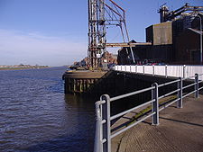
and in a short distance, at the southern end of the South Quay, it outfalls into the River Great Ouse
.
River Great Ouse
The Great Ouse is a river in the east of England. At long, it is the fourth-longest river in the United Kingdom. The river has been important for navigation, and for draining the low-lying region through which it flows. Its course has been modified several times, with the first recorded being in...
in the west of the county of Norfolk
Norfolk
Norfolk is a low-lying county in the East of England. It has borders with Lincolnshire to the west, Cambridgeshire to the west and southwest and Suffolk to the south. Its northern and eastern boundaries are the North Sea coast and to the north-west the county is bordered by The Wash. The county...
. Its source is 11 metres above sea level, northwest of the village of Gayton in Derby Fen, Map Reference TF 705 209. It runs for 6.7 miles (10.8 km) to its outflow into the River Great Ouse
River Great Ouse
The Great Ouse is a river in the east of England. At long, it is the fourth-longest river in the United Kingdom. The river has been important for navigation, and for draining the low-lying region through which it flows. Its course has been modified several times, with the first recorded being in...
in the town of King's Lynn
King's Lynn
King's Lynn is a sea port and market town in the ceremonial county of Norfolk in the East of England. It is situated north of London and west of Norwich. The population of the town is 42,800....
.
Derby Fen is the remnant of a valley fen
Fen
A fen is a type of wetland fed by mineral-rich surface water or groundwater. Fens are characterised by their water chemistry, which is neutral or alkaline, with relatively high dissolved mineral levels but few other plant nutrients...
system once found in these parts. The remnant supports a range of habitats from dry calcareous
Calcareous
Calcareous is an adjective meaning mostly or partly composed of calcium carbonate, in other words, containing lime or being chalky. The term is used in a wide variety of scientific disciplines.-In zoology:...
to damp acidic grasslands and heath
Heath (habitat)
A heath or heathland is a dwarf-shrub habitat found on mainly low quality acidic soils, characterised by open, low growing woody vegetation, often dominated by plants of the Ericaceae. There are some clear differences between heath and moorland...
which all rely on the river. From Derby Fen the stream runs under Leziate Drove and along the southern side of Sugar Fen after which the river passes into the open countryside.
In recent years, attempts have been made to restore the river to its original meandering course in the section of the river. With these improvements there have been recordings of water vole, and otter
Otter
The Otters are twelve species of semi-aquatic mammals which feed on fish and shellfish, and also other invertebrates, amphibians, birds and small mammals....
sightings. The river also has a small trout
Trout
Trout is the name for a number of species of freshwater and saltwater fish belonging to the Salmoninae subfamily of the family Salmonidae. Salmon belong to the same family as trout. Most salmon species spend almost all their lives in salt water...
population although only the lower reaches of the river support any coarse fishing
Coarse fishing
Coarse fishing is a term used in the United Kingdom and Ireland for angling for coarse fish, which are those types of freshwater fish other than game fish . The sport and the techniques used are particularly popular in the United Kingdom and mainland Europe.-History:The term "coarse fishing"...
. Just north of the village of Bawsey
Bawsey
Bawsey is a village and civil parish in the English county of Norfolk. The village is about 4 miles east of the town of King's Lynn and 40 miles west of the city of Norwich...
the river passes under a disused railway track bed and crosses the countryside westwards and skirts to the north of the ruins of St. Mary's church which stands on the small hill to the south of the river. Then the river passes under the A149
A149 road
The A149 is a major route in Norfolk, linking Kings Lynn to Great Yarmouth. It runs via the coast rather than on a more direct route such as the A47. The eastern section runs through The Broads.-Kings Lynn to Wells next the Sea:...
, King's Lynn to Hunstanton
Hunstanton
Hunstanton, often pronounced by locals as and known colloquially as 'Sunny Hunny', is a seaside town in Norfolk, England, facing The Wash....
road. Now in the lower reaches and entering the outskirts of King's Lynn the river banks have been the subject of much flood defence work. Skirting the southern side of South Wootton the river passes under the A148
A148 road
The A148 is an English A road entirely in the county of Norfolk. It runs from King's Lynn to Cromer via Fakenham which it bypasses to the north.-King’s Lynn starting point:...
and turns southwards alongside a residential street called Riverside for a short distance before running along the eastern boundary of sports fields close to King’s Lynn Leisure Centre. It is now in the district of King’s Lynn called Gaywood and here the river runs alongside River Lane before it dog-legs west towards the town centre along Swan Lane. From Swan Lane it passes through some open land and the allotments to the south before changing direction south again by Kettlewell Lane.
Kettle Watermill
It was on the bend at the top of Kettlewell Lane that the mill once stood and was known as King's LynnKing's Lynn
King's Lynn is a sea port and market town in the ceremonial county of Norfolk in the East of England. It is situated north of London and west of Norwich. The population of the town is 42,800....
Kettle Watermill
Watermill
A watermill is a structure that uses a water wheel or turbine to drive a mechanical process such as flour, lumber or textile production, or metal shaping .- History :...
. The first record shows it as being a building housing lepers. Kettle Mills does not ever appear to have ever been a manufacturing
Manufacturing
Manufacturing is the use of machines, tools and labor to produce goods for use or sale. The term may refer to a range of human activity, from handicraft to high tech, but is most commonly applied to industrial production, in which raw materials are transformed into finished goods on a large scale...
mill. However, at one point during its rich and varied career it was certainly driven by the waters of the Gaywood.
Kettle Mill was so called because the mill in the area was originally horse
Horse
The horse is one of two extant subspecies of Equus ferus, or the wild horse. It is a single-hooved mammal belonging to the taxonomic family Equidae. The horse has evolved over the past 45 to 55 million years from a small multi-toed creature into the large, single-toed animal of today...
powered and was in operation by the beginning of the 15th century, its purpose being to draw water from the river (in kettle-like containers) to supply the town's freshwater conduits. One of the earliest of which ran from the Kettlemill down Damgate to Gresemarket, with a connection south to the Saturday marketplace. The inventor of this system is said to have been one Peter Morrys, a Dutchman, and his system was adopted not only in King's Lynn, but also in Hull
Kingston upon Hull
Kingston upon Hull , usually referred to as Hull, is a city and unitary authority area in the ceremonial county of the East Riding of Yorkshire, England. It stands on the River Hull at its junction with the Humber estuary, 25 miles inland from the North Sea. Hull has a resident population of...
and other large towns and London
London
London is the capital city of :England and the :United Kingdom, the largest metropolitan area in the United Kingdom, and the largest urban zone in the European Union by most measures. Located on the River Thames, London has been a major settlement for two millennia, its history going back to its...
where several of the wooden pipes were dug up in the area of Marble Arch
Marble Arch
Marble Arch is a white Carrara marble monument that now stands on a large traffic island at the junction of Oxford Street, Park Lane, and Edgware Road, almost directly opposite Speakers' Corner in Hyde Park in London, England...
, elm
Elm
Elms are deciduous and semi-deciduous trees comprising the genus Ulmus in the plant family Ulmaceae. The dozens of species are found in temperate and tropical-montane regions of North America and Eurasia, ranging southward into Indonesia. Elms are components of many kinds of natural forests...
being the favourite wood as it was more capable of standing up to conditions and pressure than cheaper timbers. This system would eventually be found to be wasteful and dangerous to health as the pipes and pits were near to cesspools and drains. Several of these tree pipes have fairly recently been unearthed in New Conduit Street dated early 19th century. Later Kettlemill was used as a coal fired electricity plant but was eventually demolished to make way for the offices of the Local Drainage
Drainage
Drainage is the natural or artificial removal of surface and sub-surface water from an area. Many agricultural soils need drainage to improve production or to manage water supplies.-Early history:...
Board. At the southern end of Kettlewell Lane, the river passes under the A148
A148 road
The A148 is an English A road entirely in the county of Norfolk. It runs from King's Lynn to Cromer via Fakenham which it bypasses to the north.-King’s Lynn starting point:...
, Littleport Street heading south, it then passes through a culvert
Culvert
A culvert is a device used to channel water. It may be used to allow water to pass underneath a road, railway, or embankment. Culverts can be made of many different materials; steel, polyvinyl chloride and concrete are the most common...
underneath the main railway lines to King’s Lynn station.
The "Walks" and more watermills
Past the railway culvert, the river curls through the gardens and parkland of what is known as the “Walks”. In this parkland remnants of the town wall can still be seen. Also in this vicinity it is thought there was another watermill for corn called the Oyle Mil. The river now heading westwards again reaches London Road where once it is though stood another watermill called Town Mill. The mill probably stood at the top of the Millfleet near the almshouses. The mill was a single storey stone building with the two storey miller's house adjacent and probably stood on the same site as the earlier Swagges Mill. The mill was probably demolished to make way for the London Road in the 19th century.Culvert
A culvert is a device used to channel water. It may be used to allow water to pass underneath a road, railway, or embankment. Culverts can be made of many different materials; steel, polyvinyl chloride and concrete are the most common...
and in a short distance, at the southern end of the South Quay, it outfalls into the River Great Ouse
River Great Ouse
The Great Ouse is a river in the east of England. At long, it is the fourth-longest river in the United Kingdom. The river has been important for navigation, and for draining the low-lying region through which it flows. Its course has been modified several times, with the first recorded being in...
.