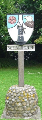
Sculthorpe, Norfolk
Encyclopedia
Sculthorpe is a village
and civil parish
in the English
county
of Norfolk
. The village is situated some 8 km (5 mi) north-west of Fakenham
and 5 km (3.1 mi) south-east of South Creake
.
The civil parish has an area of 8.52 km² (3.3 sq mi) and in 2001 had a population of 744 in 312 households. For the purposes of local government, the parish falls within the district
of North Norfolk
.
The large airfield of RAF Sculthorpe
lies immediately to the west of the village.
Sculthorpe Moor Community Nature Reserve lies to the south of the village in Turf Moor Road
Village
A village is a clustered human settlement or community, larger than a hamlet with the population ranging from a few hundred to a few thousand , Though often located in rural areas, the term urban village is also applied to certain urban neighbourhoods, such as the West Village in Manhattan, New...
and civil parish
Civil parish
In England, a civil parish is a territorial designation and, where they are found, the lowest tier of local government below districts and counties...
in the English
England
England is a country that is part of the United Kingdom. It shares land borders with Scotland to the north and Wales to the west; the Irish Sea is to the north west, the Celtic Sea to the south west, with the North Sea to the east and the English Channel to the south separating it from continental...
county
County
A county is a jurisdiction of local government in certain modern nations. Historically in mainland Europe, the original French term, comté, and its equivalents in other languages denoted a jurisdiction under the sovereignty of a count A county is a jurisdiction of local government in certain...
of Norfolk
Norfolk
Norfolk is a low-lying county in the East of England. It has borders with Lincolnshire to the west, Cambridgeshire to the west and southwest and Suffolk to the south. Its northern and eastern boundaries are the North Sea coast and to the north-west the county is bordered by The Wash. The county...
. The village is situated some 8 km (5 mi) north-west of Fakenham
Fakenham
Fakenham is a town and civil parish in Norfolk, England. It is situated on the River Wensum, some north east of King's Lynn, south west of Cromer, and north west of Norwich....
and 5 km (3.1 mi) south-east of South Creake
South Creake
South Creake is a village and civil parish in north west Norfolk, England. The village lies south of its twin village of North Creake, and some five miles north-west of the town of Fakenham....
.
The civil parish has an area of 8.52 km² (3.3 sq mi) and in 2001 had a population of 744 in 312 households. For the purposes of local government, the parish falls within the district
Non-metropolitan district
Non-metropolitan districts, or colloquially shire districts, are a type of local government district in England. As created, they are sub-divisions of non-metropolitan counties in a so-called "two-tier" arrangement...
of North Norfolk
North Norfolk
North Norfolk is a local government district in Norfolk, United Kingdom. Its council is based in Cromer. The council headquarters can be found approximately out of the town of Cromer on the Holt Road.-History:...
.
The large airfield of RAF Sculthorpe
RAF Sculthorpe
RAF Sculthorpe is a military training facility for the United Kingdom's Ministry of Defence, situated about west of Fakenham in Norfolk, England...
lies immediately to the west of the village.
Sculthorpe Moor Community Nature Reserve lies to the south of the village in Turf Moor Road

