

M23 motorway
Encyclopedia
Hooley
Hooley is a small village in Surrey, England. It lies in a "pass" which is the lowest crossing point of the North Downs for some distance in either direction. Both the London, Brighton and South Coast Railway and the South Eastern Railway recognised this pass as the best route to Brighton and built...
in Surrey
Surrey
Surrey is a county in the South East of England and is one of the Home Counties. The county borders Greater London, Kent, East Sussex, West Sussex, Hampshire and Berkshire. The historic county town is Guildford. Surrey County Council sits at Kingston upon Thames, although this has been part of...
, where it splits from the A23
A23 road
The A23 road is a major road in the United Kingdom between London and Brighton, East Sussex. It became an arterial route following the construction of Westminster Bridge in 1750 and the consequent improvement of roads leading to the bridge south of the river by the Turnpike Trusts...
, to Pease Pottage
Pease Pottage
Pease Pottage is a small village in the Mid Sussex District of West Sussex, England. It lies on the southern edge of the Crawley built up area, in the civil parish of Slaugham....
, south of Crawley
Crawley
Crawley is a town and local government district with Borough status in West Sussex, England. It is south of Charing Cross, north of Brighton and Hove, and northeast of the county town of Chichester, covers an area of and had a population of 99,744 at the time of the 2001 Census.The area has...
in West Sussex
West Sussex
West Sussex is a county in the south of England, bordering onto East Sussex , Hampshire and Surrey. The county of Sussex has been divided into East and West since the 12th century, and obtained separate county councils in 1888, but it remained a single ceremonial county until 1974 and the coming...
where it rejoins the A23. The northern end of the motorway starts at junction 7 on what is effectively a 2 miles (3.2 km) spur north from junction 7 of the M25 motorway
M25 motorway
The M25 motorway, or London Orbital, is a orbital motorway that almost encircles Greater London, England, in the United Kingdom. The motorway was first mooted early in the 20th century. A few sections, based on the now abandoned London Ringways plan, were constructed in the early 1970s and it ...
(junction 8 on the M23). From Hooley it runs for 17 miles (27.4 km) past Redhill
Redhill, Surrey
Redhill is a town in the borough of Reigate and Banstead, Surrey, England and is part of the London commuter belt. Redhill and the adjacent town of Reigate form a single urban area.-History:...
, Gatwick Airport
London Gatwick Airport
Gatwick Airport is located 3.1 miles north of the centre of Crawley, West Sussex, and south of Central London. Previously known as London Gatwick,In 2010, the name changed from London Gatwick Airport to Gatwick Airport...
and Crawley. A spur runs from junction 9 to Gatwick Airport.
History
The M23 was planned to relieve congestion on the A23 through StreathamStreatham
Streatham is a district in Surrey, England, located in the London Borough of Lambeth. It is situated south of Charing Cross. The area is identified in the London Plan as one of 35 major centres in Greater London.-History:...
, Thornton Heath
Thornton Heath
Thornton Heath is a district of south London, England, in the London Borough of Croydon. It is situated south-southeast of Charing Cross.-Geography:...
, Purley
Purley, London
Purley is a place in the London Borough of Croydon, England. It is a suburban development situated 11.7 miles south of Charing Cross.The name derives from "pirlea", which means 'Peartree lea'. Purley has a population of about 72,000....
and Coulsdon
Coulsdon
Coulsdon is a town on the southernmost boundary of the London Borough of Croydon. It is surrounded by the Metropolitan Green Belt of the Farthing Down, Coulsdon Common and Kenley Common...
in south London and was originally intended to terminate in Streatham Vale
Streatham
Streatham is a district in Surrey, England, located in the London Borough of Lambeth. It is situated south of Charing Cross. The area is identified in the London Plan as one of 35 major centres in Greater London.-History:...
at a junction with the controversial London Ringways
London Ringways
The London Ringways were a series of four ring roads planned in the 1960s to circle London at various distances from the city centre. They were part of a comprehensive scheme developed by the Greater London Council to alleviate traffic congestion on the city's road system by providing high speed...
Plan's Ringway 2
Ringway 2
Ringway 2 was the second innermost of the series of four London Ringways, ring roads planned in the 1960s to circle London at various distances from the city centre...
(the intended replacement of the South Circular Road (A205)
A205 road
The A205 or South Circular Road is a direct route which crosses South London, UK, running from Woolwich in the east to the junction of the A406 , the M4 and the A4 at Gunnersbury in the west....
).
In an earlier version of the Ringways Plan it would have continued into central London where it would have met the Balham Loop spur from Ringway 1 (the London Motorway Box)
Ringway 1
Ringway 1 or the London Motorway Box was the innermost of the series of four motorway standard roads, known as the London Ringways as part of a comprehensive scheme developed by the Greater London Council to provide high speed motorway-standard roads within the capital linking a series of radial...
at Tooting
Tooting
Tooting is a district in south London, England, located in the London Borough of Wandsworth. It is situated south south-west of Charing Cross. The area is identified in the London Plan as one of 35 major centres in Greater London.-History:...
. This was dropped in 1967 when the northern terminus was changed to Ringway 2.
By 1972 the southern section of Ringway 2 had been dropped from the plan, which meant that had the M23 continued north into inner London it would not have had the motorway required at its northern end to distribute traffic to the east and west. The M23 plan was gradually scaled back further to omit the section across Mitcham Common
Mitcham Common
Mitcham Common or Seven Islands is 182 hectares of common land situated in South London. It is predominantly in the London borough of Merton, with parts straddling the borders with Sutton and Croydon.- History :...
and end the motorway at an unsuitable location on Croydon Road (A232
A232 road
The A232 is a road running east-west across South London, which connects the A24 in Ewell with the A224 Orpington bypass.Between Croydon and Ewell the road runs close to the Sutton & Mole Valley Line...
) before the plan was postponed indefinitely. The proposals were finally dropped in the mid-1980s but much of the land reserved for the route was not released by the Department for Transport
Department for Transport
In the United Kingdom, the Department for Transport is the government department responsible for the English transport network and a limited number of transport matters in Scotland, Wales and Northern Ireland which are not devolved...
until the mid-1990s.
The missing section of motorway and the missing six junctions north of Hooley were not constructed due to difficulties in finding a practical route through Wallington
Wallington, London
Wallington is a town in the London Borough of Sutton situated south south-west of Charing Cross. Prior to the merger of the Municipal Borough of Beddington and Wallington into the London Borough of Sutton, it was part of the county of Surrey.- History :...
, Beddington
Beddington
Beddington is a settlement between the London Boroughs of Sutton and Croydon. The BedZED low energy housing scheme is located here. In Beddington was a static inverter plant of HVDC Kingsnorth....
and Mitcham
Mitcham
Mitcham is a district in the south west area of London, in the London Borough of Merton. A suburban area, Mitcham is located on the border of Inner London and Outer London. It is both residentially and financially developed, well served by Transport for London, and home to Mitcham Town Centre,...
to Streatham. Large scale residential demolitions would have been required, and local opposition to the motorway was strong. The scale of the four-tier junction between the M23 and the M25, one of only three stack interchange
Stack interchange
A stack interchange is a free-flowing grade separated junction between two roads.In countries where one drives on the right, left turns are handled by semi-directional flyover/under ramps...
s in the UK, is indicative of the importance attached to the M23 at that time.
The motorway was constructed between 1972 and 1975, at the same time as the southern section of the M25 from Godstone
Godstone
Godstone is a village in the county of Surrey, England. It is located approximately six miles east of Reigate at the junction of the A22 and A25 major roads, and near the M25 motorway.-History:...
to Reigate
Reigate
Reigate is a historic market town in Surrey, England, at the foot of the North Downs, and in the London commuter belt. It is one of the main constituents of the Borough of Reigate and Banstead...
(M25 junctions 6 to 8). The current northern terminus at junction 7 uses the original sliproads to meet the A23 and a flyover above the junction built for the onward northern continuation remains unused.
A new junction (J10A) was opened in 1997, between J10 and J11, for access to the new Crawley
Crawley
Crawley is a town and local government district with Borough status in West Sussex, England. It is south of Charing Cross, north of Brighton and Hove, and northeast of the county town of Chichester, covers an area of and had a population of 99,744 at the time of the 2001 Census.The area has...
neighbourhood of Maidenbower
Maidenbower, Crawley
Maidenbower is a neighbourhood within the town of Crawley in West Sussex, England. Maidenbower is located in the south east corner of the town bordering the M23 motorway. It is bordered by Pound Hill to the north and Furnace Green to the west across the railway line.Maidenbower is the newest of...
. It was financed as part of the development of Maidenbower by the construction consortium. It gives only off-access southbound and on-access northbound.
Junctions
Data from driver location signsDriver location signs
Driver location signs are English highway route markers, first introduced in 2003, that complement distance marker posts. Both types of marker post display the distances from a nominal start point in kilometres...
are used to provide distance and carriageway identifier information. Where a junction spans several hundred metres and start and end points are available, both are cited.
| M23 Motorway | ||||
| km | mile | Northbound exits (B Carriageway) | Junction | Southbound exits (A Carriageway) |
| 27.4 | 17 | [Road continues as A23 A23 road The A23 road is a major road in the United Kingdom between London and Brighton, East Sussex. It became an arterial route following the construction of Westminster Bridge in 1750 and the consequent improvement of roads leading to the bridge south of the river by the Turnpike Trusts... to Croydon] Croydon A23 |
J7 | Crawley, Gatwick A23 A23 road The A23 road is a major road in the United Kingdom between London and Brighton, East Sussex. It became an arterial route following the construction of Westminster Bridge in 1750 and the consequent improvement of roads leading to the bridge south of the river by the Turnpike Trusts... Non-motorway traffic [Start of motorway] |
| 28.2 | 17.5 | |||
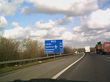
| 30.5 | 19 | Reigate Reigate Reigate is a historic market town in Surrey, England, at the foot of the North Downs, and in the London commuter belt. It is one of the main constituents of the Borough of Reigate and Banstead... , Heathrow Airport, Oxford Oxford The city of Oxford is the county town of Oxfordshire, England. The city, made prominent by its medieval university, has a population of just under 165,000, with 153,900 living within the district boundary. It lies about 50 miles north-west of London. The rivers Cherwell and Thames run through... , Sevenoaks Sevenoaks Sevenoaks is a commuter town situated on the London fringe of west Kent, England, some 20 miles south-east of Charing Cross, on one of the principal commuter rail lines from the capital... , Maidstone Maidstone Maidstone is the county town of Kent, England, south-east of London. The River Medway runs through the centre of the town linking Maidstone to Rochester and the Thames Estuary. Historically, the river was a source and route for much of the town's trade. Maidstone was the centre of the agricultural... , Stansted Airport, (M3, M4 M4 motorway The M4 motorway links London with South Wales. It is part of the unsigned European route E30. Other major places directly accessible from M4 junctions are Reading, Swindon, Bristol, Newport, Cardiff and Swansea... , M40 M40 motorway The M40 motorway is a motorway in the British transport network that forms a major part of the connection between London and Birmingham. Part of this road forms a section of the unsigned European route E05... , M1 M1 motorway The M1 is a north–south motorway in England primarily connecting London to Leeds, where it joins the A1 near Aberford. While the M1 is considered to be the first inter-urban motorway to be completed in the United Kingdom, the first road to be built to motorway standard in the country was the... , M20 M20 motorway The M20 is a motorway in Kent, England. It runs from the M25 motorway to Folkestone, providing a link to the Channel Tunnel and the ports at Dover. It is long... , M11 M11 motorway The M11 motorway in England is a major road running approximately north from the North Circular Road in South Woodford in north-east London to the A14, north-west of Cambridge.-Route:... ), M25 M25 motorway The M25 motorway, or London Orbital, is a orbital motorway that almost encircles Greater London, England, in the United Kingdom. The motorway was first mooted early in the 20th century. A few sections, based on the now abandoned London Ringways plan, were constructed in the early 1970s and it ... |
J8 | Heathrow Airport (M4) , Stansted Airport (M11) Maidstone (M20) (M3, M40, M26) M25 |
| 31 | 19.3 | |||
| 42.7 | 26.5 | Gatwick Airport, Redhill, Reigate A23 | J9 | Gatwick Airport, Redhill, Reigate A23 |
| 43.1 | 26.8 | |||
| 45.8 | 28.5 | Crawley A2220 East Grinstead A264 A264 road The A264 is an east-west road in southern England that runs from Pembury in west Kent to Five Oaks in West Sussex.There have been a number of notable changes in this important east-west route which follows the north Sussex border with Kent and Surrey.... |
J10 | Crawley A2220 East Grinstead A264 |
| 46.1 | 28.6 | |||
| 48.8 | 30.3 | rowspan=2 No exit | J10a | Crawley B2036 |
| 49.2 | 30.6 | |||
| 53.3 | 33.1 | [Start of motorway] Crawley A23 Non-motorway traffic Pease Pottage services Pease Pottage services Pease Pottage services is a motorway service station on the M23 motorway near Crawley in West Sussex, southern England. It is owned by Moto. Facilities on the site include a Marks & Spencer store, Burger King and a Costa Coffee... |
J11 Services |
Brighton, Crawley A23 Horsham A264 Pease Pottage services Pease Pottage services Pease Pottage services is a motorway service station on the M23 motorway near Crawley in West Sussex, southern England. It is owned by Moto. Facilities on the site include a Marks & Spencer store, Burger King and a Costa Coffee... [Road continues as A23 to Brighton Brighton Brighton is the major part of the city of Brighton and Hove in East Sussex, England on the south coast of Great Britain... ] |
| 53.8 | 33.4 | |||