
1943 Atlantic hurricane season
Encyclopedia
The 1943 Atlantic hurricane season officially began on June 16, 1943, and lasted until October 31, 1943. These dates conventionally delimit the period of each year when most tropical cyclone
s form in the Atlantic basin
.
The 1943 hurricane season
was fairly quiet but was significant for one event: the Surprise Hurricane in July was the first tropical cyclone to be investigated by airplane. Two more flights were made during August into a stronger hurricane in the central Atlantic. These early flights paved the way for the Hurricane Hunters
forecasters at the National Hurricane Center
have come to rely.
. It was conducted by an Army Air Corps
(now the United States Air Force
) aircraft. Valuable information was gathered about hurricanes and hurricane structure.
on August 13 and moved generally northwest for the next four days, shifting slightly more northward late on August 15. Its winds peaked at 60 mi/h and the storm recurved to the northeast on August 18 several hundred miles southeast of Cape Fear, dissipating in the north Atlantic a day later.
. It headed northwestward, strengthening to a hurricane on August 20 over the open Atlantic. The hurricane peaked at 140 mi/h winds, Category 4 on the Saffir-Simpson Hurricane Scale
and passed 100 miles (160.9 km) west of Bermuda
on August 25. The storm was very large and despite the distance, Bermuda briefly reported hurricane force winds, but these winds caused little damage or injury. The hurricane turned northeastward, and became extratropical on August 26 over the North Atlantic.
in early September. It formed well southeast of Bermuda and was not discovered until it was almost a hurricane. The hurricane moved north-northwest, steadily strengthening until it was parallel to Bermuda on September 3. By that time, it was a Category 2
hurricane and was getting still stronger. The hurricane came under influence of a strong high pressure system that slowed it to a crawl. It began to slowly curve eastward and then back north and west, making a half circle that it took four days to complete. In that time it reached its peak intensity of 120 mi/h, a major hurricane on the Saffir-Simpson Hurricane Scale
. The hurricane was weakening now, but not much given the latitude. The storm did not drop below Category 2 status until it was almost across 40N. It recurved to the northeast, finally weakening to a tropical storm shortly before clipping Cape Breton Island
, Nova Scotia
. The storm sped up and ended its days over Newfoundland, having become extratropical.
. No damage from these winds was reported, however. The storm curved northeastward and became extratropical 150 miles (241.4 km) southeast of Cape Cod
.
on September 15. It moved to the northwest and became a hurricane early the next day. A ridge of high pressure to the north forced the hurricane southward, where it attained a peak of 95 mi/h winds on September 17. It rapidly weakened as it drifted northeastward, completing a tight loop, and hit southern Louisiana
on September 20 as a minimal tropical storm. It dissipated shortly thereafter, after causing $195,000 (1943 dollars) in damage, mostly from flooding.
on October 1, and dissipated later that day. Tropical Storm Seven was responsible for sinking one small boat and causing $20,000 in damage (1943 dollars).
while at its peak intensity of 70 mi/h, near-hurricane force. The storm moved swiftly, forming a long curve. It passed right by Bermuda shortly before weakening from peak intensity, raking the island with 40 mi/h sustained winds. It continued its parabolic recurve to the north and then northeast, picking up speed as it did so. It became extratropical a few hundred miles south-southeast of Cape Breton Island
three days after discovery. No damage was reported in Bermuda.
on October 15. It wouldn't change direction much for the remainder of its lifetime. Early the next day, the hurricane reached a peak of 110 mi/h winds, which it maintained before weakening dramatically early on October 17. The hurricane became extratropical later that day, and moved inland near the Maine
/New Brunswick
border, dissipating over Canada
.
n coast six hours later as a weak tropical storm. The storm dissipated over the center of the country.
Tropical cyclone
A tropical cyclone is a storm system characterized by a large low-pressure center and numerous thunderstorms that produce strong winds and heavy rain. Tropical cyclones strengthen when water evaporated from the ocean is released as the saturated air rises, resulting in condensation of water vapor...
s form in the Atlantic basin
Atlantic Basin
The Atlantic Basin is the Atlantic Ocean.Atlantic Basin may also refer to:* Atlantic Basin Iron Works, an ironworks that operated in Brooklyn, New York, in the early to mid-20th century...
.
The 1943 hurricane season
Atlantic hurricane season
The Atlantic hurricane season is the period in a year when hurricanes usually form in the Atlantic Ocean. Tropical cyclones in the North Atlantic are called hurricanes, tropical storms, or tropical depressions. In addition, there have been several storms over the years that have not been fully...
was fairly quiet but was significant for one event: the Surprise Hurricane in July was the first tropical cyclone to be investigated by airplane. Two more flights were made during August into a stronger hurricane in the central Atlantic. These early flights paved the way for the Hurricane Hunters
Hurricane Hunters
The Hurricane Hunters are aircraft that fly into tropical cyclones in the North Atlantic Ocean and Northeastern Pacific Ocean for the specific purpose of directly measuring weather data in and around those storms. In the United States, the Air Force, Navy, and NOAA units have all participated in...
forecasters at the National Hurricane Center
National Hurricane Center
The National Hurricane Center , located at Florida International University in Miami, Florida, is the division of the National Weather Service responsible for tracking and predicting weather systems within the tropics between the Prime Meridian and the 140th meridian west poleward to the 30th...
have come to rely.
Hurricane One
In late July, the first intentional flight into a hurricane was flown into what became known as the Surprise Hurricane1943 Surprise Hurricane
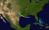
The 1943 Surprise Hurricane struck the Houston, Texas area on July 27, 1943. While not a major hurricane, the storm was described as the worst since the 1915 hurricane, which tested the newly constructed seawall at Galveston.-Meteorological history:...
. It was conducted by an Army Air Corps
United States Army Air Corps
The United States Army Air Corps was a forerunner of the United States Air Force. Renamed from the Air Service on 2 July 1926, it was part of the United States Army and the predecessor of the United States Army Air Forces , established in 1941...
(now the United States Air Force
United States Air Force
The United States Air Force is the aerial warfare service branch of the United States Armed Forces and one of the American uniformed services. Initially part of the United States Army, the USAF was formed as a separate branch of the military on September 18, 1947 under the National Security Act of...
) aircraft. Valuable information was gathered about hurricanes and hurricane structure.
Tropical Storm Two
This storm formed near the Leeward IslandsLeeward Islands
The Leeward Islands are a group of islands in the West Indies. They are the northern islands of the Lesser Antilles chain. As a group they start east of Puerto Rico and reach southward to Dominica. They are situated where the northeastern Caribbean Sea meets the western Atlantic Ocean...
on August 13 and moved generally northwest for the next four days, shifting slightly more northward late on August 15. Its winds peaked at 60 mi/h and the storm recurved to the northeast on August 18 several hundred miles southeast of Cape Fear, dissipating in the north Atlantic a day later.
Hurricane Three
On August 19, a tropical storm was first observed east of the Lesser AntillesLesser Antilles
The Lesser Antilles are a long, partly volcanic island arc in the Western Hemisphere. Most of its islands form the eastern boundary of the Caribbean Sea with the Atlantic Ocean, with the remainder located in the southern Caribbean just north of South America...
. It headed northwestward, strengthening to a hurricane on August 20 over the open Atlantic. The hurricane peaked at 140 mi/h winds, Category 4 on the Saffir-Simpson Hurricane Scale
Saffir-Simpson Hurricane Scale
The Saffir–Simpson Hurricane Scale , or the Saffir–Simpson Hurricane Wind Scale , classifies hurricanes — Western Hemisphere tropical cyclones that exceed the intensities of tropical depressions and tropical storms — into five categories distinguished by the intensities of their sustained winds...
and passed 100 miles (160.9 km) west of Bermuda
Bermuda
Bermuda is a British overseas territory in the North Atlantic Ocean. Located off the east coast of the United States, its nearest landmass is Cape Hatteras, North Carolina, about to the west-northwest. It is about south of Halifax, Nova Scotia, Canada, and northeast of Miami, Florida...
on August 25. The storm was very large and despite the distance, Bermuda briefly reported hurricane force winds, but these winds caused little damage or injury. The hurricane turned northeastward, and became extratropical on August 26 over the North Atlantic.
Hurricane Four
The fourth storm of the season had an erratic track across the open Atlantic not far east of BermudaBermuda
Bermuda is a British overseas territory in the North Atlantic Ocean. Located off the east coast of the United States, its nearest landmass is Cape Hatteras, North Carolina, about to the west-northwest. It is about south of Halifax, Nova Scotia, Canada, and northeast of Miami, Florida...
in early September. It formed well southeast of Bermuda and was not discovered until it was almost a hurricane. The hurricane moved north-northwest, steadily strengthening until it was parallel to Bermuda on September 3. By that time, it was a Category 2
Saffir-Simpson Hurricane Scale
The Saffir–Simpson Hurricane Scale , or the Saffir–Simpson Hurricane Wind Scale , classifies hurricanes — Western Hemisphere tropical cyclones that exceed the intensities of tropical depressions and tropical storms — into five categories distinguished by the intensities of their sustained winds...
hurricane and was getting still stronger. The hurricane came under influence of a strong high pressure system that slowed it to a crawl. It began to slowly curve eastward and then back north and west, making a half circle that it took four days to complete. In that time it reached its peak intensity of 120 mi/h, a major hurricane on the Saffir-Simpson Hurricane Scale
Saffir-Simpson Hurricane Scale
The Saffir–Simpson Hurricane Scale , or the Saffir–Simpson Hurricane Wind Scale , classifies hurricanes — Western Hemisphere tropical cyclones that exceed the intensities of tropical depressions and tropical storms — into five categories distinguished by the intensities of their sustained winds...
. The hurricane was weakening now, but not much given the latitude. The storm did not drop below Category 2 status until it was almost across 40N. It recurved to the northeast, finally weakening to a tropical storm shortly before clipping Cape Breton Island
Cape Breton Island
Cape Breton Island is an island on the Atlantic coast of North America. It likely corresponds to the word Breton, the French demonym for Brittany....
, Nova Scotia
Nova Scotia
Nova Scotia is one of Canada's three Maritime provinces and is the most populous province in Atlantic Canada. The name of the province is Latin for "New Scotland," but "Nova Scotia" is the recognized, English-language name of the province. The provincial capital is Halifax. Nova Scotia is the...
. The storm sped up and ended its days over Newfoundland, having become extratropical.
Tropical Storm Five
Storm Five formed northeast of Grand Bahama Island on September 13 and headed due north for the next 24 hours, passing not more than a couple hundred miles off the US east coast, bring gale-force winds to the Outer BanksOuter Banks
The Outer Banks is a 200-mile long string of narrow barrier islands off the coast of North Carolina, beginning in the southeastern corner of Virginia Beach on the east coast of the United States....
. No damage from these winds was reported, however. The storm curved northeastward and became extratropical 150 miles (241.4 km) southeast of Cape Cod
Cape Cod
Cape Cod, often referred to locally as simply the Cape, is a cape in the easternmost portion of the state of Massachusetts, in the Northeastern United States...
.
Hurricane Six
A tropical storm developed in the western Gulf of MexicoGulf of Mexico
The Gulf of Mexico is a partially landlocked ocean basin largely surrounded by the North American continent and the island of Cuba. It is bounded on the northeast, north and northwest by the Gulf Coast of the United States, on the southwest and south by Mexico, and on the southeast by Cuba. In...
on September 15. It moved to the northwest and became a hurricane early the next day. A ridge of high pressure to the north forced the hurricane southward, where it attained a peak of 95 mi/h winds on September 17. It rapidly weakened as it drifted northeastward, completing a tight loop, and hit southern Louisiana
Louisiana
Louisiana is a state located in the southern region of the United States of America. Its capital is Baton Rouge and largest city is New Orleans. Louisiana is the only state in the U.S. with political subdivisions termed parishes, which are local governments equivalent to counties...
on September 20 as a minimal tropical storm. It dissipated shortly thereafter, after causing $195,000 (1943 dollars) in damage, mostly from flooding.
Tropical Storm Seven
A tropical wave formed into a tropical storm on September 28, south-southwest of Bermuda. It headed northwestward, reaching a peak of 60 mi/h winds the next day. The storm made landfall near Ocean City, MarylandOcean City, Maryland
Ocean City, sometimes known as OC, or OCMD, is an Atlantic Ocean resort town in Worcester County, Maryland, United States. Ocean City is widely known in the Mid-Atlantic region of the United States and is a frequent destination for vacationers in that area...
on October 1, and dissipated later that day. Tropical Storm Seven was responsible for sinking one small boat and causing $20,000 in damage (1943 dollars).
Tropical Storm Eight
This storm was first discovered on October 1 several hundred miles southeast of BermudaBermuda
Bermuda is a British overseas territory in the North Atlantic Ocean. Located off the east coast of the United States, its nearest landmass is Cape Hatteras, North Carolina, about to the west-northwest. It is about south of Halifax, Nova Scotia, Canada, and northeast of Miami, Florida...
while at its peak intensity of 70 mi/h, near-hurricane force. The storm moved swiftly, forming a long curve. It passed right by Bermuda shortly before weakening from peak intensity, raking the island with 40 mi/h sustained winds. It continued its parabolic recurve to the north and then northeast, picking up speed as it did so. It became extratropical a few hundred miles south-southeast of Cape Breton Island
Cape Breton Island
Cape Breton Island is an island on the Atlantic coast of North America. It likely corresponds to the word Breton, the French demonym for Brittany....
three days after discovery. No damage was reported in Bermuda.
Hurricane Nine
On October 11, a tropical storm was first detected over the Lesser Antilles. It moved westward, reaching hurricane strength the next day. The hurricane turned due northward and moved through the Mona PassageMona Passage
The Mona Passage is a strait that separates the islands of Hispaniola and Puerto Rico. The Mona Passage connects the Atlantic Ocean to the Caribbean Sea, and is an important shipping route between the Atlantic and the Panama Canal....
on October 15. It wouldn't change direction much for the remainder of its lifetime. Early the next day, the hurricane reached a peak of 110 mi/h winds, which it maintained before weakening dramatically early on October 17. The hurricane became extratropical later that day, and moved inland near the Maine
Maine
Maine is a state in the New England region of the northeastern United States, bordered by the Atlantic Ocean to the east and south, New Hampshire to the west, and the Canadian provinces of Quebec to the northwest and New Brunswick to the northeast. Maine is both the northernmost and easternmost...
/New Brunswick
New Brunswick
New Brunswick is one of Canada's three Maritime provinces and is the only province in the federation that is constitutionally bilingual . The provincial capital is Fredericton and Saint John is the most populous city. Greater Moncton is the largest Census Metropolitan Area...
border, dissipating over Canada
Canada
Canada is a North American country consisting of ten provinces and three territories. Located in the northern part of the continent, it extends from the Atlantic Ocean in the east to the Pacific Ocean in the west, and northward into the Arctic Ocean...
.
Tropical Storm Ten
The final storm of the season was a weak system that formed in the western Caribbean Sea on October 20 and curved northwest and then west, paralleling the coast of Honduras but remaining well offshore. Winds in this storm never rose above 45 mi/h. It began to curve back southwest on October 22, clipping the coast of southern Belize and making landfall on the GuatemalaGuatemala
Guatemala is a country in Central America bordered by Mexico to the north and west, the Pacific Ocean to the southwest, Belize to the northeast, the Caribbean to the east, and Honduras and El Salvador to the southeast...
n coast six hours later as a weak tropical storm. The storm dissipated over the center of the country.