
1940 Atlantic hurricane season
Encyclopedia
The 1940 Atlantic hurricane season officially began on June 16, 1940, and lasted until October 31, 1940. These dates conventionally delimit the period of each year when most tropical cyclone
s form in the Atlantic basin
. Two flooding storms impacted the southern and eastern United States
during August in relatively quick succession.
in 2009
.
, a frontal wave
developed into a tropical storm on August 2 off the coast of Florida
. It moved westward, and hit Florida early the next day. The storm continued westward, crossing the Gulf of Mexico
while slowly strengthening to an 80 mi/h hurricane. The hurricane hit near the Texas
/Louisiana
border on August 8, and dissipated three days later over Missouri. Prolific rainfall and flooding occurred over Acadiana
due to this system, which is one of the wettest on record for the state of Louisiana
. Six casualties and $6 million in damage from flooding can be attributed to this hurricane.
. It tracked generally to the northwest, and became a hurricane on August 8. After reaching a peak of 90 mi/h winds, the hurricane weakened to a minimal hurricane until hitting near the Georgia
/South Carolina
border on August 11. It moved slowly northwestward, and became extratropical on August 14 over Kentucky
. It drifted eastward, and dropped heavy rain and flooding. The hurricane caused around 100 deaths, 80 from the mountainous flooding, and $3 million in damage at the coastal area of Georgia and South Carolina. Damage estimates are not available from the extratropical remnant.
. The storm strengthened rather rapidly, its winds increasing to hurricane force and the pressure falling to 978 hectopascals (28.9 inHg) on the same day it was discovered. Brushing North Carolina
's Outer Banks
, the hurricane turned to the north-northeast, maintaining intensity. After passing offshore of Cape Cod
and approaching the Bay of Fundy
, the storm winds finally weakened below hurricane force. Storm Four made landfall along the coast of New Brunswick
on September 3 as it became extratropical.
formed in the tropical Atlantic a several hundred miles northeast of the Leeward Islands
on September 10. The storm passed north of the eastern Greater Antilles
on a west-northwestward track, steadily strengthening, becoming a hurricane north of Hispaniola
. The hurricane continued to strengthen as it turned north-northeast. Upon reaching Category 2
strength, the storm did not strengthen further. Maintaining heading and intensity for the next two days, cooler water finally weakened the storm on September 15. However, Storm Five maintained hurricane intensity and struck southern Nova Scotia
with 75 mi/h winds. Continuing northeast as a tropical storm, it eventually became extratropical over Newfoundland
. No damage or human fatalities were reported.
, and after crossing the Yucatan Peninsula it moved across the Gulf of Mexico the northwest. As it neared the Texan coast, it slowed and turned to the east, paralleling the Texas and Louisiana coastlines before making landfall on September 24 over southern Louisiana. It dissipated the next day, after causing heavy flooding, amounting to 7 inches (177.8 mm) in some locations throughout its path.
, Storm Seven never attained winds higher than 50 mi/h. It moved north and then curved west, impacting Nicaragua
as a weak system on October 23. Despite its low intensity, Storm Seven caused considerable damage from freshwater flooding.
Tropical cyclone
A tropical cyclone is a storm system characterized by a large low-pressure center and numerous thunderstorms that produce strong winds and heavy rain. Tropical cyclones strengthen when water evaporated from the ocean is released as the saturated air rises, resulting in condensation of water vapor...
s form in the Atlantic basin
Atlantic Basin
The Atlantic Basin is the Atlantic Ocean.Atlantic Basin may also refer to:* Atlantic Basin Iron Works, an ironworks that operated in Brooklyn, New York, in the early to mid-20th century...
. Two flooding storms impacted the southern and eastern United States
United States
The United States of America is a federal constitutional republic comprising fifty states and a federal district...
during August in relatively quick succession.
Tropical Storm One
A tropical storm formed and existed entirely during the month of May; an unusual occurrence. It caused no damage or deaths. The time of year, formation and track were very similar to Tropical Depression OneTropical Depression One (2009)
Tropical Depression One was the first tropical cyclone to develop during the 2009 Atlantic hurricane season. Upon being declared a tropical depression on May 28, it marked the third time that a pre-season storm formed in three consecutive years...
in 2009
2009 Atlantic hurricane season
The 2009 Atlantic hurricane season was a below-average year, unlike the 2009 Pacific hurricane season, which was above average, both due to a moderate El Niño. During this year, nine tropical storms formed, the fewest since the 1997 season.An average season has ten tropical storms, six hurricanes...
.
Hurricane Two
At the southern end of a weather frontWeather front
A weather front is a boundary separating two masses of air of different densities, and is the principal cause of meteorological phenomena. In surface weather analyses, fronts are depicted using various colored lines and symbols, depending on the type of front...
, a frontal wave
Extratropical cyclone
Extratropical cyclones, sometimes called mid-latitude cyclones or wave cyclones, are a group of cyclones defined as synoptic scale low pressure weather systems that occur in the middle latitudes of the Earth having neither tropical nor polar characteristics, and are connected with fronts and...
developed into a tropical storm on August 2 off the coast of Florida
Florida
Florida is a state in the southeastern United States, located on the nation's Atlantic and Gulf coasts. It is bordered to the west by the Gulf of Mexico, to the north by Alabama and Georgia and to the east by the Atlantic Ocean. With a population of 18,801,310 as measured by the 2010 census, it...
. It moved westward, and hit Florida early the next day. The storm continued westward, crossing the Gulf of Mexico
Gulf of Mexico
The Gulf of Mexico is a partially landlocked ocean basin largely surrounded by the North American continent and the island of Cuba. It is bounded on the northeast, north and northwest by the Gulf Coast of the United States, on the southwest and south by Mexico, and on the southeast by Cuba. In...
while slowly strengthening to an 80 mi/h hurricane. The hurricane hit near the Texas
Texas
Texas is the second largest U.S. state by both area and population, and the largest state by area in the contiguous United States.The name, based on the Caddo word "Tejas" meaning "friends" or "allies", was applied by the Spanish to the Caddo themselves and to the region of their settlement in...
/Louisiana
Louisiana
Louisiana is a state located in the southern region of the United States of America. Its capital is Baton Rouge and largest city is New Orleans. Louisiana is the only state in the U.S. with political subdivisions termed parishes, which are local governments equivalent to counties...
border on August 8, and dissipated three days later over Missouri. Prolific rainfall and flooding occurred over Acadiana
Acadiana
Acadiana, or The Heart of Acadiana, is the official name given to the French Louisiana region that is home to a large Francophone population. Of the 64 parishes that make up Louisiana, 22 named parishes and other parishes of similar cultural environment, make up the intrastate...
due to this system, which is one of the wettest on record for the state of Louisiana
Louisiana
Louisiana is a state located in the southern region of the United States of America. Its capital is Baton Rouge and largest city is New Orleans. Louisiana is the only state in the U.S. with political subdivisions termed parishes, which are local governments equivalent to counties...
. Six casualties and $6 million in damage from flooding can be attributed to this hurricane.
Hurricane Three
A tropical storm was first observed on August 5, north of the Lesser AntillesLesser Antilles
The Lesser Antilles are a long, partly volcanic island arc in the Western Hemisphere. Most of its islands form the eastern boundary of the Caribbean Sea with the Atlantic Ocean, with the remainder located in the southern Caribbean just north of South America...
. It tracked generally to the northwest, and became a hurricane on August 8. After reaching a peak of 90 mi/h winds, the hurricane weakened to a minimal hurricane until hitting near the Georgia
Georgia (U.S. state)
Georgia is a state located in the southeastern United States. It was established in 1732, the last of the original Thirteen Colonies. The state is named after King George II of Great Britain. Georgia was the fourth state to ratify the United States Constitution, on January 2, 1788...
/South Carolina
South Carolina
South Carolina is a state in the Deep South of the United States that borders Georgia to the south, North Carolina to the north, and the Atlantic Ocean to the east. Originally part of the Province of Carolina, the Province of South Carolina was one of the 13 colonies that declared independence...
border on August 11. It moved slowly northwestward, and became extratropical on August 14 over Kentucky
Kentucky
The Commonwealth of Kentucky is a state located in the East Central United States of America. As classified by the United States Census Bureau, Kentucky is a Southern state, more specifically in the East South Central region. Kentucky is one of four U.S. states constituted as a commonwealth...
. It drifted eastward, and dropped heavy rain and flooding. The hurricane caused around 100 deaths, 80 from the mountainous flooding, and $3 million in damage at the coastal area of Georgia and South Carolina. Damage estimates are not available from the extratropical remnant.
Hurricane Four
Discovered as a strengthening tropical storm in late August, Storm Four headed northwest toward the East Coast of the United StatesEast Coast of the United States
The East Coast of the United States, also known as the Eastern Seaboard, refers to the easternmost coastal states in the United States, which touch the Atlantic Ocean and stretch up to Canada. The term includes the U.S...
. The storm strengthened rather rapidly, its winds increasing to hurricane force and the pressure falling to 978 hectopascals (28.9 inHg) on the same day it was discovered. Brushing North Carolina
North Carolina
North Carolina is a state located in the southeastern United States. The state borders South Carolina and Georgia to the south, Tennessee to the west and Virginia to the north. North Carolina contains 100 counties. Its capital is Raleigh, and its largest city is Charlotte...
's Outer Banks
Outer Banks
The Outer Banks is a 200-mile long string of narrow barrier islands off the coast of North Carolina, beginning in the southeastern corner of Virginia Beach on the east coast of the United States....
, the hurricane turned to the north-northeast, maintaining intensity. After passing offshore of Cape Cod
Cape Cod
Cape Cod, often referred to locally as simply the Cape, is a cape in the easternmost portion of the state of Massachusetts, in the Northeastern United States...
and approaching the Bay of Fundy
Bay of Fundy
The Bay of Fundy is a bay on the Atlantic coast of North America, on the northeast end of the Gulf of Maine between the Canadian provinces of New Brunswick and Nova Scotia, with a small portion touching the U.S. state of Maine...
, the storm winds finally weakened below hurricane force. Storm Four made landfall along the coast of New Brunswick
New Brunswick
New Brunswick is one of Canada's three Maritime provinces and is the only province in the federation that is constitutionally bilingual . The provincial capital is Fredericton and Saint John is the most populous city. Greater Moncton is the largest Census Metropolitan Area...
on September 3 as it became extratropical.
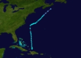
Hurricane Five
The strongest storm of the 1940 seasonAtlantic hurricane season
The Atlantic hurricane season is the period in a year when hurricanes usually form in the Atlantic Ocean. Tropical cyclones in the North Atlantic are called hurricanes, tropical storms, or tropical depressions. In addition, there have been several storms over the years that have not been fully...
formed in the tropical Atlantic a several hundred miles northeast of the Leeward Islands
Leeward Islands
The Leeward Islands are a group of islands in the West Indies. They are the northern islands of the Lesser Antilles chain. As a group they start east of Puerto Rico and reach southward to Dominica. They are situated where the northeastern Caribbean Sea meets the western Atlantic Ocean...
on September 10. The storm passed north of the eastern Greater Antilles
Greater Antilles
The Greater Antilles are one of three island groups in the Caribbean. Comprising Cuba, Jamaica, Hispaniola , and Puerto Rico, the Greater Antilles constitute almost 90% of the land mass of the entire West Indies.-Greater Antilles in context :The islands of the Caribbean Sea, collectively known as...
on a west-northwestward track, steadily strengthening, becoming a hurricane north of Hispaniola
Hispaniola
Hispaniola is a major island in the Caribbean, containing the two sovereign states of the Dominican Republic and Haiti. The island is located between the islands of Cuba to the west and Puerto Rico to the east, within the hurricane belt...
. The hurricane continued to strengthen as it turned north-northeast. Upon reaching Category 2
Saffir-Simpson Hurricane Scale
The Saffir–Simpson Hurricane Scale , or the Saffir–Simpson Hurricane Wind Scale , classifies hurricanes — Western Hemisphere tropical cyclones that exceed the intensities of tropical depressions and tropical storms — into five categories distinguished by the intensities of their sustained winds...
strength, the storm did not strengthen further. Maintaining heading and intensity for the next two days, cooler water finally weakened the storm on September 15. However, Storm Five maintained hurricane intensity and struck southern Nova Scotia
Nova Scotia
Nova Scotia is one of Canada's three Maritime provinces and is the most populous province in Atlantic Canada. The name of the province is Latin for "New Scotland," but "Nova Scotia" is the recognized, English-language name of the province. The provincial capital is Halifax. Nova Scotia is the...
with 75 mi/h winds. Continuing northeast as a tropical storm, it eventually became extratropical over Newfoundland
Newfoundland and Labrador
Newfoundland and Labrador is the easternmost province of Canada. Situated in the country's Atlantic region, it incorporates the island of Newfoundland and mainland Labrador with a combined area of . As of April 2011, the province's estimated population is 508,400...
. No damage or human fatalities were reported.
Tropical Storm Six
A tropical storm formed just east of Bluefields, Nicaragua on September 19. It moved northwestward, hitting the country shortly thereafter and reaching the Gulf of Honduras on September 20. Early the next day, the storm made landfall on modern-day BelizeBelize
Belize is a constitutional monarchy and the northernmost country in Central America. Belize has a diverse society, comprising many cultures and languages. Even though Kriol and Spanish are spoken among the population, Belize is the only country in Central America where English is the official...
, and after crossing the Yucatan Peninsula it moved across the Gulf of Mexico the northwest. As it neared the Texan coast, it slowed and turned to the east, paralleling the Texas and Louisiana coastlines before making landfall on September 24 over southern Louisiana. It dissipated the next day, after causing heavy flooding, amounting to 7 inches (177.8 mm) in some locations throughout its path.
Tropical Storm Seven
Forming from a late-October disturbance in the southwest Caribbean SeaCaribbean Sea
The Caribbean Sea is a sea of the Atlantic Ocean located in the tropics of the Western hemisphere. It is bounded by Mexico and Central America to the west and southwest, to the north by the Greater Antilles, and to the east by the Lesser Antilles....
, Storm Seven never attained winds higher than 50 mi/h. It moved north and then curved west, impacting Nicaragua
Nicaragua
Nicaragua is the largest country in the Central American American isthmus, bordered by Honduras to the north and Costa Rica to the south. The country is situated between 11 and 14 degrees north of the Equator in the Northern Hemisphere, which places it entirely within the tropics. The Pacific Ocean...
as a weak system on October 23. Despite its low intensity, Storm Seven caused considerable damage from freshwater flooding.
Tropical Storm Eight
Another weak tropical storm formed near the Turks and Caicos islands on October 24. The storm's winds peaked at 45 mi/h as it curved northeast out to sea, dissipating a couple days later.See also
- List of tropical cyclones
- List of Atlantic hurricane seasons
- List of wettest tropical cyclones in Louisiana