
1933 Chesapeake Potomac Hurricane
Encyclopedia
The 1933 Chesapeake-Potomac Hurricane was the eighth storm and third hurricane of the very active 1933 Atlantic hurricane season
. The August storm formed in the central Atlantic
, where it moved west-northwest. Aided by the warm ocean waters, the hurricane briefly reached Category 3 status on the Saffir–Simpson Hurricane Scale before making landfall along the Virginia
/North Carolina
coast as a Category 1 storm.
The hurricane caused severe damage along the East Coast of the United States
. The state hardest hit by the storm was Virginia, where the center of circulation passed directly over Norfolk
. The hurricane was the worst storm to strike Virginia until Hurricane Isabel
of 2003. Elsewhere, the hurricane left damage across Maryland
, Washington, D.C.
and Delaware
. In all, the hurricane caused $27.2 million (1933 USD
, $ USD) in damage and 30 fatalities.
. The storm became a hurricane just hours later and continued on its west-northwest heading, reaching Category 2 status on August 19 and passing 150 miles (241 km) to the south of Bermuda
. Then the storm slowed its forward speed and reached a peak intensity of 120 mph (193 km/h) and an estimated low pressure of 971 mbar
(hPa
; 28.67 inHg
). The hurricane then quickly weakened before hitting the northern Outer Banks
of North Carolina
as a Category 2 hurricane. The hurricane's center then passed directly over Norfolk
as a strong tropical storm on August 23, as the storm rapidly curved to the northeast. The hurricane then crossed over New England
as a tropical depression.
 Hurricane warnings were issued on August 21. The warnings extended from Cape Hatteras
to Boston
. The next day the warnings were extended to Southport, North Carolina
. Evacuations may or may not have taken place.
to hit the East Coast since 1821. In all, the storm caused $27.2 million dollars (1933) dollars of damage and left 18-30 fatalities.
was considered severe, with monetary damage estimated at $250,000 (1933 USD). In Virginia
, a weather station in Norfolk
recorded sustained winds of 56 mph (90 km/h), while Cape Henry
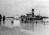
reported a wind gust of 82 mph (132 km/h). Several tide gauges reported tides 7–9 feet above normal and a storm surge
of 6–9 feet. The high tides and storm surge flooded much of downtown Norfolk and sank ten ships. Elsewhere along the coast, the hurricane's storm surge caused severe beach erosion. On Cedar Island
, the hurricane destroyed a hotel and several other buildings. In Surry County
, the storm surge from the hurricane caused the James River
to overflow its banks and sweep away a ferry pier. The York River
also rose 5–8 feet above flood stage. The flooding along the York River caused severe damage in Gloucester County
. Further inland, strong winds knocked out power and phone service in Alexandria
, while flooding knocked out roads and flooded a Ford Motor Company
plant. In Fairfax County
and Loudoun County
, flooding caused severe damage to farms and crops. Richmond
sustained $250,000 dollars (1933 USD, $33.8 million 2005 USD) in damage, mainly to trees and roofs. In all the hurricane killed 18 people in Virginia
and left $10 million dollars (1933 USD).
, the storm produced a storm surge of 11.3 feet (3.4 m), rainfall of 6.18 inches (152 mm) and winds of 50 mph (80 km/h). In Maryland
, the hurricane caused $17 million dollars (1933 USD, $230 million 2005 USD) in damage to crops and buildings. The storm also destroyed a railroad bridge heading into Ocean City
and created the Ocean City
Inlet between the town and Assateague Island
. The storm killed 13 people and 1,000+ animals. On the coast, the storm damaged or destroyed several wharfs and fishing piers. In Delaware
, the storm caused $150,000 dollars (1933 USD, $2.03 million 2005 USD) in damage but no deaths. Damage was also reported in New Jersey
, although damage figures are unknown. At least 7 were reported dead. Offshore, the hurricane sank or badly damaged 100 boats and ships.
the American Red Cross
collected over $300,000 (1933 USD, $4,063,200USD) in relief during the cleanup after the storm.
to form before September, a record held until 2005, when Tropical Storm Harvey
formed on August 2.
The 1933 hurricane's track and impact was similar to Hurricane Isabel
in 2003. Both storms struck northeastern North Carolina as a Category 1 or 2 hurricane, and both left severe damage in southeastern Virginia
. The wind speed and pressure at landfall brought by the 1933 storm was tied by Hurricane Isabel
in 2003. However, the record tidal surge was broken by Isabel.
1933 Atlantic hurricane season
The 1933 Atlantic hurricane season was the second most active Atlantic hurricane season on record, with 21 storms forming during that year in the northwest Atlantic Ocean. The season ran through the summer and the first half of fall in 1933, and was surpassed in total number of tropical cyclones by...
. The August storm formed in the central Atlantic
Atlantic Ocean
The Atlantic Ocean is the second-largest of the world's oceanic divisions. With a total area of about , it covers approximately 20% of the Earth's surface and about 26% of its water surface area...
, where it moved west-northwest. Aided by the warm ocean waters, the hurricane briefly reached Category 3 status on the Saffir–Simpson Hurricane Scale before making landfall along the Virginia
Virginia
The Commonwealth of Virginia , is a U.S. state on the Atlantic Coast of the Southern United States. Virginia is nicknamed the "Old Dominion" and sometimes the "Mother of Presidents" after the eight U.S. presidents born there...
/North Carolina
North Carolina
North Carolina is a state located in the southeastern United States. The state borders South Carolina and Georgia to the south, Tennessee to the west and Virginia to the north. North Carolina contains 100 counties. Its capital is Raleigh, and its largest city is Charlotte...
coast as a Category 1 storm.
The hurricane caused severe damage along the East Coast of the United States
East Coast of the United States
The East Coast of the United States, also known as the Eastern Seaboard, refers to the easternmost coastal states in the United States, which touch the Atlantic Ocean and stretch up to Canada. The term includes the U.S...
. The state hardest hit by the storm was Virginia, where the center of circulation passed directly over Norfolk
Norfolk, Virginia
Norfolk is an independent city in the Commonwealth of Virginia in the United States. With a population of 242,803 as of the 2010 Census, it is Virginia's second-largest city behind neighboring Virginia Beach....
. The hurricane was the worst storm to strike Virginia until Hurricane Isabel
Hurricane Isabel
Hurricane Isabel was the costliest and deadliest hurricane in the 2003 Atlantic hurricane season. The ninth named storm, fifth hurricane, and second major hurricane of the season, Isabel formed near the Cape Verde Islands from a tropical wave on September 6 in the tropical Atlantic Ocean...
of 2003. Elsewhere, the hurricane left damage across Maryland
Maryland
Maryland is a U.S. state located in the Mid Atlantic region of the United States, bordering Virginia, West Virginia, and the District of Columbia to its south and west; Pennsylvania to its north; and Delaware to its east...
, Washington, D.C.
Washington, D.C.
Washington, D.C., formally the District of Columbia and commonly referred to as Washington, "the District", or simply D.C., is the capital of the United States. On July 16, 1790, the United States Congress approved the creation of a permanent national capital as permitted by the U.S. Constitution....
and Delaware
Delaware
Delaware is a U.S. state located on the Atlantic Coast in the Mid-Atlantic region of the United States. It is bordered to the south and west by Maryland, and to the north by Pennsylvania...
. In all, the hurricane caused $27.2 million (1933 USD
United States dollar
The United States dollar , also referred to as the American dollar, is the official currency of the United States of America. It is divided into 100 smaller units called cents or pennies....
, $ USD) in damage and 30 fatalities.
Meteorological history
A strong tropical storm was detected on August 17 northeast of the Leeward IslandsLeeward Islands
The Leeward Islands are a group of islands in the West Indies. They are the northern islands of the Lesser Antilles chain. As a group they start east of Puerto Rico and reach southward to Dominica. They are situated where the northeastern Caribbean Sea meets the western Atlantic Ocean...
. The storm became a hurricane just hours later and continued on its west-northwest heading, reaching Category 2 status on August 19 and passing 150 miles (241 km) to the south of Bermuda
Bermuda
Bermuda is a British overseas territory in the North Atlantic Ocean. Located off the east coast of the United States, its nearest landmass is Cape Hatteras, North Carolina, about to the west-northwest. It is about south of Halifax, Nova Scotia, Canada, and northeast of Miami, Florida...
. Then the storm slowed its forward speed and reached a peak intensity of 120 mph (193 km/h) and an estimated low pressure of 971 mbar
Bar (unit)
The bar is a unit of pressure equal to 100 kilopascals, and roughly equal to the atmospheric pressure on Earth at sea level. Other units derived from the bar are the megabar , kilobar , decibar , centibar , and millibar...
(hPa
Pascal (unit)
The pascal is the SI derived unit of pressure, internal pressure, stress, Young's modulus and tensile strength, named after the French mathematician, physicist, inventor, writer, and philosopher Blaise Pascal. It is a measure of force per unit area, defined as one newton per square metre...
; 28.67 inHg
Inch of mercury
Inches of mercury, ' is a unit of measurement for pressure. It is still widely used for barometric pressure in weather reports, refrigeration and aviation in the United States, but is seldom used elsewhere....
). The hurricane then quickly weakened before hitting the northern Outer Banks
Outer Banks
The Outer Banks is a 200-mile long string of narrow barrier islands off the coast of North Carolina, beginning in the southeastern corner of Virginia Beach on the east coast of the United States....
of North Carolina
North Carolina
North Carolina is a state located in the southeastern United States. The state borders South Carolina and Georgia to the south, Tennessee to the west and Virginia to the north. North Carolina contains 100 counties. Its capital is Raleigh, and its largest city is Charlotte...
as a Category 2 hurricane. The hurricane's center then passed directly over Norfolk
Norfolk, Virginia
Norfolk is an independent city in the Commonwealth of Virginia in the United States. With a population of 242,803 as of the 2010 Census, it is Virginia's second-largest city behind neighboring Virginia Beach....
as a strong tropical storm on August 23, as the storm rapidly curved to the northeast. The hurricane then crossed over New England
New England
New England is a region in the northeastern corner of the United States consisting of the six states of Maine, New Hampshire, Vermont, Massachusetts, Rhode Island, and Connecticut...
as a tropical depression.
Preparations
Cape Hatteras
Cape Hatteras is a cape on the coast of North Carolina. It is the point that protrudes the farthest to the southeast along the northeast-to-southwest line of the Atlantic coast of North America...
to Boston
Boston
Boston is the capital of and largest city in Massachusetts, and is one of the oldest cities in the United States. The largest city in New England, Boston is regarded as the unofficial "Capital of New England" for its economic and cultural impact on the entire New England region. The city proper had...
. The next day the warnings were extended to Southport, North Carolina
Southport, North Carolina
Southport is a city in Brunswick County, North Carolina, near the mouth of the Cape Fear River. It is part of the Wilmington Metropolitan Statistical Area...
. Evacuations may or may not have taken place.
Impact
The Chesapeake-Potomac Hurricane was the most severe Atlantic hurricaneAtlantic hurricane
North Atlantic tropical cyclones usually form in the northern hemisphere summer or fall. Tropical cyclones can be categorized by intensity. Tropical storms have one-minute maximum sustained winds of at least 39 mph , while hurricanes have one-minute maximum sustained exceeding 74 mph...
to hit the East Coast since 1821. In all, the storm caused $27.2 million dollars (1933) dollars of damage and left 18-30 fatalities.
North Carolina and Virginia
In Cape Hatteras, North Carolina, winds up to hurricane force were reported. Damage in North CarolinaNorth Carolina
North Carolina is a state located in the southeastern United States. The state borders South Carolina and Georgia to the south, Tennessee to the west and Virginia to the north. North Carolina contains 100 counties. Its capital is Raleigh, and its largest city is Charlotte...
was considered severe, with monetary damage estimated at $250,000 (1933 USD). In Virginia
Virginia
The Commonwealth of Virginia , is a U.S. state on the Atlantic Coast of the Southern United States. Virginia is nicknamed the "Old Dominion" and sometimes the "Mother of Presidents" after the eight U.S. presidents born there...
, a weather station in Norfolk
Norfolk, Virginia
Norfolk is an independent city in the Commonwealth of Virginia in the United States. With a population of 242,803 as of the 2010 Census, it is Virginia's second-largest city behind neighboring Virginia Beach....
recorded sustained winds of 56 mph (90 km/h), while Cape Henry
Cape Henry
Cape Henry is a cape on the Atlantic shore of Virginia north of Virginia Beach. It is the southern boundary of the entrance to Chesapeake Bay.Across the mouth of the bay to the north is Cape Charles...
reported a wind gust of 82 mph (132 km/h). Several tide gauges reported tides 7–9 feet above normal and a storm surge
Storm surge
A storm surge is an offshore rise of water associated with a low pressure weather system, typically tropical cyclones and strong extratropical cyclones. Storm surges are caused primarily by high winds pushing on the ocean's surface. The wind causes the water to pile up higher than the ordinary sea...
of 6–9 feet. The high tides and storm surge flooded much of downtown Norfolk and sank ten ships. Elsewhere along the coast, the hurricane's storm surge caused severe beach erosion. On Cedar Island
Cedar Island, North Carolina
Cedar Island is an island and a small coastal unincorporated community in eastern North Carolina and some folks believe that the area has a connection to the Roanoke Lost Colony of the late 16th century. Cedar Island is located in Carteret County and was populated with local Native Americans prior...
, the hurricane destroyed a hotel and several other buildings. In Surry County
Surry County, Virginia
As of the census of 2010, there were 7,058 people, 2,619 households, and 1,917 families residing in the county. The population density was 24 people per square mile . There were 3,294 housing units at an average density of 12 per square mile...
, the storm surge from the hurricane caused the James River
James River (Virginia)
The James River is a river in the U.S. state of Virginia. It is long, extending to if one includes the Jackson River, the longer of its two source tributaries. The James River drains a catchment comprising . The watershed includes about 4% open water and an area with a population of 2.5 million...
to overflow its banks and sweep away a ferry pier. The York River
York River (Virginia)
The York River is a navigable estuary, approximately long, in eastern Virginia in the United States. It ranges in width from at its head to near its mouth on the west side of Chesapeake Bay. Its watershed drains an area including portions of 17 counties of the coastal plain of Virginia north...
also rose 5–8 feet above flood stage. The flooding along the York River caused severe damage in Gloucester County
Gloucester County, Virginia
Gloucester County is within the Commonwealth of Virginia in the Hampton Roads metropolitan area in the USA. Formed in 1651 in the Virginia Colony, the county was named for Henry Stuart, Duke of Gloucester, third son of King Charles I of Great Britain. Located in the Middle Peninsula region, it...
. Further inland, strong winds knocked out power and phone service in Alexandria
Alexandria, Virginia
Alexandria is an independent city in the Commonwealth of Virginia. As of 2009, the city had a total population of 139,966. Located along the Western bank of the Potomac River, Alexandria is approximately six miles south of downtown Washington, D.C.Like the rest of northern Virginia, as well as...
, while flooding knocked out roads and flooded a Ford Motor Company
Ford Motor Company
Ford Motor Company is an American multinational automaker based in Dearborn, Michigan, a suburb of Detroit. The automaker was founded by Henry Ford and incorporated on June 16, 1903. In addition to the Ford and Lincoln brands, Ford also owns a small stake in Mazda in Japan and Aston Martin in the UK...
plant.
Fairfax County, Virginia
Fairfax County is a county in Virginia, in the United States. Per the 2010 Census, the population of the county is 1,081,726, making it the most populous jurisdiction in the Commonwealth of Virginia, with 13.5% of Virginia's population...
and Loudoun County
Loudoun County, Virginia
Loudoun County is a county located in the Commonwealth of Virginia, and is part of the Washington Metropolitan Area. As of the 2010 U.S. Census, the county is estimated to be home to 312,311 people, an 84 percent increase over the 2000 figure of 169,599. That increase makes the county the fourth...
, flooding caused severe damage to farms and crops. Richmond
Richmond, Virginia
Richmond is the capital of the Commonwealth of Virginia, in the United States. It is an independent city and not part of any county. Richmond is the center of the Richmond Metropolitan Statistical Area and the Greater Richmond area...
sustained $250,000 dollars (1933 USD, $33.8 million 2005 USD) in damage, mainly to trees and roofs. In all the hurricane killed 18 people in Virginia
Virginia
The Commonwealth of Virginia , is a U.S. state on the Atlantic Coast of the Southern United States. Virginia is nicknamed the "Old Dominion" and sometimes the "Mother of Presidents" after the eight U.S. presidents born there...
and left $10 million dollars (1933 USD).
Mid Atlantic
In Washington, D.C.Washington, D.C.
Washington, D.C., formally the District of Columbia and commonly referred to as Washington, "the District", or simply D.C., is the capital of the United States. On July 16, 1790, the United States Congress approved the creation of a permanent national capital as permitted by the U.S. Constitution....
, the storm produced a storm surge of 11.3 feet (3.4 m), rainfall of 6.18 inches (152 mm) and winds of 50 mph (80 km/h). In Maryland
Maryland
Maryland is a U.S. state located in the Mid Atlantic region of the United States, bordering Virginia, West Virginia, and the District of Columbia to its south and west; Pennsylvania to its north; and Delaware to its east...
, the hurricane caused $17 million dollars (1933 USD, $230 million 2005 USD) in damage to crops and buildings. The storm also destroyed a railroad bridge heading into Ocean City
Ocean City, Maryland
Ocean City, sometimes known as OC, or OCMD, is an Atlantic Ocean resort town in Worcester County, Maryland, United States. Ocean City is widely known in the Mid-Atlantic region of the United States and is a frequent destination for vacationers in that area...
and created the Ocean City
Ocean City, Maryland
Ocean City, sometimes known as OC, or OCMD, is an Atlantic Ocean resort town in Worcester County, Maryland, United States. Ocean City is widely known in the Mid-Atlantic region of the United States and is a frequent destination for vacationers in that area...
Inlet between the town and Assateague Island
Assateague Island
Assateague Island is a long barrier island located off the eastern coast of Maryland and Virginia. It is best known for its herds of feral horses, pristine beaches, and the Assateague Lighthouse. The island also contains numerous marshes, bays and coves, including Toms Cove...
. The storm killed 13 people and 1,000+ animals. On the coast, the storm damaged or destroyed several wharfs and fishing piers. In Delaware
Delaware
Delaware is a U.S. state located on the Atlantic Coast in the Mid-Atlantic region of the United States. It is bordered to the south and west by Maryland, and to the north by Pennsylvania...
, the storm caused $150,000 dollars (1933 USD, $2.03 million 2005 USD) in damage but no deaths. Damage was also reported in New Jersey
New Jersey
New Jersey is a state in the Northeastern and Middle Atlantic regions of the United States. , its population was 8,791,894. It is bordered on the north and east by the state of New York, on the southeast and south by the Atlantic Ocean, on the west by Pennsylvania and on the southwest by Delaware...
, although damage figures are unknown. At least 7 were reported dead. Offshore, the hurricane sank or badly damaged 100 boats and ships.
Aftermath
In MarylandMaryland
Maryland is a U.S. state located in the Mid Atlantic region of the United States, bordering Virginia, West Virginia, and the District of Columbia to its south and west; Pennsylvania to its north; and Delaware to its east...
the American Red Cross
American Red Cross
The American Red Cross , also known as the American National Red Cross, is a volunteer-led, humanitarian organization that provides emergency assistance, disaster relief and education inside the United States. It is the designated U.S...
collected over $300,000 (1933 USD, $4,063,200USD) in relief during the cleanup after the storm.
Statistics
The Chesapeake-Potomac Hurricane held the record of being the earliest eighth Atlantic tropical cycloneTropical cyclone
A tropical cyclone is a storm system characterized by a large low-pressure center and numerous thunderstorms that produce strong winds and heavy rain. Tropical cyclones strengthen when water evaporated from the ocean is released as the saturated air rises, resulting in condensation of water vapor...
to form before September, a record held until 2005, when Tropical Storm Harvey
Tropical Storm Harvey (2005)
Tropical Storm Harvey was a strong tropical storm over the western Atlantic Ocean in August during the 2005 Atlantic hurricane season. Harvey was the eighth named storm of the record-breaking season....
formed on August 2.
The 1933 hurricane's track and impact was similar to Hurricane Isabel
Hurricane Isabel
Hurricane Isabel was the costliest and deadliest hurricane in the 2003 Atlantic hurricane season. The ninth named storm, fifth hurricane, and second major hurricane of the season, Isabel formed near the Cape Verde Islands from a tropical wave on September 6 in the tropical Atlantic Ocean...
in 2003. Both storms struck northeastern North Carolina as a Category 1 or 2 hurricane, and both left severe damage in southeastern Virginia
Virginia
The Commonwealth of Virginia , is a U.S. state on the Atlantic Coast of the Southern United States. Virginia is nicknamed the "Old Dominion" and sometimes the "Mother of Presidents" after the eight U.S. presidents born there...
. The wind speed and pressure at landfall brought by the 1933 storm was tied by Hurricane Isabel
Hurricane Isabel
Hurricane Isabel was the costliest and deadliest hurricane in the 2003 Atlantic hurricane season. The ninth named storm, fifth hurricane, and second major hurricane of the season, Isabel formed near the Cape Verde Islands from a tropical wave on September 6 in the tropical Atlantic Ocean...
in 2003. However, the record tidal surge was broken by Isabel.
See also
- tropical cycloneTropical cycloneA tropical cyclone is a storm system characterized by a large low-pressure center and numerous thunderstorms that produce strong winds and heavy rain. Tropical cyclones strengthen when water evaporated from the ocean is released as the saturated air rises, resulting in condensation of water vapor...
- list of tropical cyclones
- list of Atlantic hurricanes
- List of Delaware hurricanes
- List of North Carolina hurricanes