

1906 Valparaíso earthquake
Encyclopedia
The 1906 Valparaíso earthquake was a strong earthquake
that hit Valparaíso
, Chile
, on August 16, 1906 at 19:55 local time
. Its epicenter
was offshore from the Valparaíso Region
, and its intensity was estimated at magnitude 8.2 MW
.
Much of Valparaíso was destroyed; there was severe damage in central Chile
from Illapel
to Talca
. The earthquake was felt from Tacna
, Peru
to Puerto Montt
. Reports said the earthquake lasted four minutes. A tsunami
was also generated. The earthquake killed a reported 3,886 people.
The record of previous seismic activity includes major earthquakes in 1647, 1730 and 1822. The 1906 disaster was predicted by Captain Arturo Middleton, Chief of the Chilean Army Meteorological Office, in a letter that was published in El Mercurio
, one week before it occurred.
Admiral Luis Gómez Carreño ordered the shooting of at least 15 people, who were caught looting after the earthquake. A Board for Reconstruction was formed some weeks after the earthquake. The Seismological Service of Chile was also created. Fernand de Montessus de Ballore was appointed as the first chief executive of the Service.
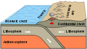 Chile lies above a convergent plate boundary
, an area where the Nazca Plate
under the Pacific Ocean is subducted
or moved beneath the South American Plate
. In the region around Valaparaiso, the rate of convergence is about 70 mm/yr. As these two plates converge, it drives the Nazca plate with massive movements called megathrust earthquakes. The 1906 event was one of many large earthquakes in Chile along this plate boundary. Earthquakes can originate at the plate interface itself or within either the subducting or overriding plates.
Citing the conjunction of Neptune
with the moon, Captain Arturo Middleton, Chief of the Chilean Army
's Meteorological Office, predicted the earthquake in a letter published in the Valparaíso newspaper El Mercurio
on August 6. Captain Middleton was severely criticized in the following days, and was qualified as "ignorant and obscurantist."
The magnitude of the earthquake has been estimated to be 8.4 ML
, 8.2 MW or MS
= 8.2–8.3. The energy release has been re-evaluated with an estimated seismic moment
of 2.8 x 1028, equivalent to a magnitude of 8.26 MW. The rupture length of the earthquake has been estimated at about 200 km with a focal depth
of about 40 km. The focal mechanism
, has been assessed using contemporary seismograph records from five stations, which were published soon after the earthquake. The data suggest that the earthquake was probably along the subduction interface. Modelling of a tsunami using these source parameters shows that this earthquake was the origin of the transpacific tsunamis recorded that same day in Hawaii
and Japan
, rather than the almost contemporaneous 1906 Aleutian earthquake.
The 30-second time gap between the Aleutian and Chilean earthquakes is thought to be coincidental, with no causal link between the two.
to Talca
. There were several destructive fires in El Almendral (from Plaza de la Victoria to Cerro Barón), Mercado Cardonal, Teatro de la Victoria (Victory Theatre), the Intendencia, the Maritime Government in Sotomayor Square and the Fiscal Dock at the port.
The earthquake was also felt in Santiago
, the capital of Chile. The newspaper El Mercurio reported in its August 17 edition that "the earthquake was produced in a violent way since its beginning, and provoked an indescribable panic through all the four thousands of inhabitants of Santiago and an unprecedented terror in the last years. Two or three-story buildings, even the most solid ones such as the National Congress, were swinging like a vessel in the sea. The shakings were so strong that many people thought the earth was going to open itself in deep and long strips.".
According to the University of Chile, there were deaths. The earthquake left more than 20,000 injured.
On August 19, Admiral Luis Gómez Carreño was appointed Plaza Port Chief. Gómez ordered the distribution of water and food, removal of corpses and demolition of buildings in risk of collapse, from a tent in Plaza de La Victoria. Adm. Gómez ordered the shooting of at least 15 people who had committed crimes during the aftermath.
and Talcahuano
, moved to Valparaíso to help the local Fire Bureau. Physician José Grossi worked to counteract the plagues that followed the earthquake.
On August 25, President
Germán Riesco
and President-elect Pedro Montt
arrived at Valparaíso. They moved there by train, on foot, or horseback to survey the magnitude of the disaster.
Some weeks after the earthquake, a Board for Reconstruction was formed, using money received from other countries.
The effects of this historic seismic event in the Valpariso rupture zone would be studied and measurable in the context of further activity in this vicinity.
Earthquake
An earthquake is the result of a sudden release of energy in the Earth's crust that creates seismic waves. The seismicity, seismism or seismic activity of an area refers to the frequency, type and size of earthquakes experienced over a period of time...
that hit Valparaíso
Valparaíso
Valparaíso is a city and commune of Chile, center of its third largest conurbation and one of the country's most important seaports and an increasing cultural center in the Southwest Pacific hemisphere. The city is the capital of the Valparaíso Province and the Valparaíso Region...
, Chile
Chile
Chile ,officially the Republic of Chile , is a country in South America occupying a long, narrow coastal strip between the Andes mountains to the east and the Pacific Ocean to the west. It borders Peru to the north, Bolivia to the northeast, Argentina to the east, and the Drake Passage in the far...
, on August 16, 1906 at 19:55 local time
Time in Chile
Continental Chile is situated geographically in UTC−05.Currently, Chile uses 2 different UTC offsets at any given point in the calendar year. Since it practices daylight saving time, in total 4 time zones are used...
. Its epicenter
Epicenter
The epicenter or epicentre is the point on the Earth's surface that is directly above the hypocenter or focus, the point where an earthquake or underground explosion originates...
was offshore from the Valparaíso Region
Valparaíso Region
The V Valparaíso Region is one of Chile's 15 first order administrative divisions.Valparaíso Region, 2006 With the country's third highest population of 1,539,852 million in 2002 and third smallest area of , the region is Chile's second most densely populated after the Santiago Metropolitan Region...
, and its intensity was estimated at magnitude 8.2 MW
Moment magnitude scale
The moment magnitude scale is used by seismologists to measure the size of earthquakes in terms of the energy released. The magnitude is based on the seismic moment of the earthquake, which is equal to the rigidity of the Earth multiplied by the average amount of slip on the fault and the size of...
.
Much of Valparaíso was destroyed; there was severe damage in central Chile
Zona Central
Zona Central can refer to:* Zona Central, Chile* Zona Central, Rio de Janeiro, Brazil* Downtown São Paulo, Brazil...
from Illapel
Illapel
Illapel is a Chilean city, which is the capital of the Choapa Province, Coquimbo Region. It lies along the Illapel River and marks the country's narrowest point along a parallel .It's located to the east of Los Vilos.-Administration:...
to Talca
Talca
Talca is a city and commune in Chile located about south of Santiago, and is the capital of both Talca Province and Maule Region . As of the 2002 census, the city had a population of 193,755....
. The earthquake was felt from Tacna
Tacna
- Rail :Tacna is served by a cross-border standard gauge railway to Arica, Chile.It is also the location of the National Railway Museum of Peru.-Air:Tacna is served by the Crnl. FAP...
, Peru
Peru
Peru , officially the Republic of Peru , is a country in western South America. It is bordered on the north by Ecuador and Colombia, on the east by Brazil, on the southeast by Bolivia, on the south by Chile, and on the west by the Pacific Ocean....
to Puerto Montt
Puerto Montt
Puerto Montt is a port city and commune in southern Chile, located at the northern end of the Reloncaví Sound in the Llanquihue Province, Los Lagos Region. The commune spans an area of and had a population of 175,938 in 2002. It is located 1,055 km to the south of the capital, Santiago...
. Reports said the earthquake lasted four minutes. A tsunami
Tsunami
A tsunami is a series of water waves caused by the displacement of a large volume of a body of water, typically an ocean or a large lake...
was also generated. The earthquake killed a reported 3,886 people.
The record of previous seismic activity includes major earthquakes in 1647, 1730 and 1822. The 1906 disaster was predicted by Captain Arturo Middleton, Chief of the Chilean Army Meteorological Office, in a letter that was published in El Mercurio
El Mercurio
El Mercurio is a conservative Chilean newspaper with editions in Valparaíso and Santiago. Its Santiago edition is considered the country's paper-of-record and its Valparaíso edition is the oldest daily in the Spanish language currently in circulation. El Mercurio is owned by El Mercurio S.A.P...
, one week before it occurred.
Admiral Luis Gómez Carreño ordered the shooting of at least 15 people, who were caught looting after the earthquake. A Board for Reconstruction was formed some weeks after the earthquake. The Seismological Service of Chile was also created. Fernand de Montessus de Ballore was appointed as the first chief executive of the Service.
Background
Convergent boundary
In plate tectonics, a convergent boundary, also known as a destructive plate boundary , is an actively deforming region where two tectonic plates or fragments of lithosphere move toward one another and collide...
, an area where the Nazca Plate
Nazca Plate
]The Nazca Plate, named after the Nazca region of southern Peru, is an oceanic tectonic plate in the eastern Pacific Ocean basin off the west coast of South America. The ongoing subduction along the Peru-Chile Trench of the Nazca Plate under the South American Plate is largely responsible for the...
under the Pacific Ocean is subducted
Subduction
In geology, subduction is the process that takes place at convergent boundaries by which one tectonic plate moves under another tectonic plate, sinking into the Earth's mantle, as the plates converge. These 3D regions of mantle downwellings are known as "Subduction Zones"...
or moved beneath the South American Plate
South American Plate
The South American Plate is a continental tectonic plate which includes the continent of South America and also a sizeable region of the Atlantic Ocean seabed extending eastward to the Mid-Atlantic Ridge....
. In the region around Valaparaiso, the rate of convergence is about 70 mm/yr. As these two plates converge, it drives the Nazca plate with massive movements called megathrust earthquakes. The 1906 event was one of many large earthquakes in Chile along this plate boundary. Earthquakes can originate at the plate interface itself or within either the subducting or overriding plates.
Citing the conjunction of Neptune
Neptune
Neptune is the eighth and farthest planet from the Sun in the Solar System. Named for the Roman god of the sea, it is the fourth-largest planet by diameter and the third largest by mass. Neptune is 17 times the mass of Earth and is slightly more massive than its near-twin Uranus, which is 15 times...
with the moon, Captain Arturo Middleton, Chief of the Chilean Army
Chilean Army
The Chilean Army is the land arm of the Military of Chile. This 45,000-person army is organized into seven divisions, a special operations brigade and an air brigade....
's Meteorological Office, predicted the earthquake in a letter published in the Valparaíso newspaper El Mercurio
El Mercurio
El Mercurio is a conservative Chilean newspaper with editions in Valparaíso and Santiago. Its Santiago edition is considered the country's paper-of-record and its Valparaíso edition is the oldest daily in the Spanish language currently in circulation. El Mercurio is owned by El Mercurio S.A.P...
on August 6. Captain Middleton was severely criticized in the following days, and was qualified as "ignorant and obscurantist."
Earthquake characteristics
On August 16, 1906 at 19:55 local time, while most Chileans were dining, a subterraneous sound was heard, and before it ended, the first tremor occurred, lasting about four minutes. The second tremor occurred at 20:06 and, although it lasted only two minutes, was much more violent. There were several aftershocks: at least 56 of them occurred during the first 24 hours after the beginning tremors.The magnitude of the earthquake has been estimated to be 8.4 ML
Richter magnitude scale
The expression Richter magnitude scale refers to a number of ways to assign a single number to quantify the energy contained in an earthquake....
, 8.2 MW or MS
Surface wave magnitude
The surface wave magnitude scale is one of the magnitude scales used in seismology to describe the size of an earthquake. It is based on measurements in Rayleigh surface waves that travel primarily along the uppermost layers of the earth...
= 8.2–8.3. The energy release has been re-evaluated with an estimated seismic moment
Seismic moment
Seismic moment is a quantity used by earthquake seismologists to measure the size of an earthquake. The scalar seismic moment M_0 is defined by the equationM_0=\mu AD, where*\mu is the shear modulus of the rocks involved in the earthquake...
of 2.8 x 1028, equivalent to a magnitude of 8.26 MW. The rupture length of the earthquake has been estimated at about 200 km with a focal depth
Hypocenter
The hypocenter refers to the site of an earthquake or a nuclear explosion...
of about 40 km. The focal mechanism
Focal mechanism
The focal mechanism of an earthquake describes the inelastic deformation in the source region that generates the seismic waves. In the case of a fault-related event it refers to the orientation of the fault plane that slipped and the slip vector and is also known as a fault-plane solution...
, has been assessed using contemporary seismograph records from five stations, which were published soon after the earthquake. The data suggest that the earthquake was probably along the subduction interface. Modelling of a tsunami using these source parameters shows that this earthquake was the origin of the transpacific tsunamis recorded that same day in Hawaii
Hawaii
Hawaii is the newest of the 50 U.S. states , and is the only U.S. state made up entirely of islands. It is the northernmost island group in Polynesia, occupying most of an archipelago in the central Pacific Ocean, southwest of the continental United States, southeast of Japan, and northeast of...
and Japan
Japan
Japan is an island nation in East Asia. Located in the Pacific Ocean, it lies to the east of the Sea of Japan, China, North Korea, South Korea and Russia, stretching from the Sea of Okhotsk in the north to the East China Sea and Taiwan in the south...
, rather than the almost contemporaneous 1906 Aleutian earthquake.
The 30-second time gap between the Aleutian and Chilean earthquakes is thought to be coincidental, with no causal link between the two.
Damage
The earthquake caused damage throughout Central Chile, from IllapelIllapel
Illapel is a Chilean city, which is the capital of the Choapa Province, Coquimbo Region. It lies along the Illapel River and marks the country's narrowest point along a parallel .It's located to the east of Los Vilos.-Administration:...
to Talca
Talca
Talca is a city and commune in Chile located about south of Santiago, and is the capital of both Talca Province and Maule Region . As of the 2002 census, the city had a population of 193,755....
. There were several destructive fires in El Almendral (from Plaza de la Victoria to Cerro Barón), Mercado Cardonal, Teatro de la Victoria (Victory Theatre), the Intendencia, the Maritime Government in Sotomayor Square and the Fiscal Dock at the port.
The earthquake was also felt in Santiago
Santiago, Chile
Santiago , also known as Santiago de Chile, is the capital and largest city of Chile, and the center of its largest conurbation . It is located in the country's central valley, at an elevation of above mean sea level...
, the capital of Chile. The newspaper El Mercurio reported in its August 17 edition that "the earthquake was produced in a violent way since its beginning, and provoked an indescribable panic through all the four thousands of inhabitants of Santiago and an unprecedented terror in the last years. Two or three-story buildings, even the most solid ones such as the National Congress, were swinging like a vessel in the sea. The shakings were so strong that many people thought the earth was going to open itself in deep and long strips.".
According to the University of Chile, there were deaths. The earthquake left more than 20,000 injured.
On August 19, Admiral Luis Gómez Carreño was appointed Plaza Port Chief. Gómez ordered the distribution of water and food, removal of corpses and demolition of buildings in risk of collapse, from a tent in Plaza de La Victoria. Adm. Gómez ordered the shooting of at least 15 people who had committed crimes during the aftermath.
Relief efforts
Despite the state of the city, authorities quickly organized themselves into relief groups. Firefighters from other cities of Chile, including Santiago, ConcepciónConcepción, Chile
Concepción is a city in Chile, capital of Concepción Province and of the Biobío Region or Region VIII. Greater Concepción is the second-largest conurbation in the country, with 889,725 inhabitants...
and Talcahuano
Talcahuano
Talcahuano is a port city and commune in the Biobío Region of Chile. It is part of the Greater Concepción conurbation. Talcahuano is located in the south of the Central Zone of Chile.-Geography:...
, moved to Valparaíso to help the local Fire Bureau. Physician José Grossi worked to counteract the plagues that followed the earthquake.
On August 25, President
President of Chile
The President of the Republic of Chile is both the head of state and the head of government of the Republic of Chile. The President is responsible of the government and state administration...
Germán Riesco
Germán Riesco
Germán Riesco Errázuriz was a Chilean political figure, and he served as President of Chile between 1901 and 1906.-Early life:...
and President-elect Pedro Montt
Pedro Montt
Pedro Elías Pablo Montt Montt was a Chilean political figure. He served as the president of Chile from 1906 to his death from a probable stroke in 1910...
arrived at Valparaíso. They moved there by train, on foot, or horseback to survey the magnitude of the disaster.
Some weeks after the earthquake, a Board for Reconstruction was formed, using money received from other countries.
Long-term consequences
In 1906, the Seismological Service of Chile (Servicio Sismológico de Chile) was created. Its first chief executive was Fernand de Montessus de Ballore.The effects of this historic seismic event in the Valpariso rupture zone would be studied and measurable in the context of further activity in this vicinity.
External links
- TERREMOTO DE 1906 in Valparaíso Fire Bureau's website