
Årdal
Encyclopedia
Årdal is a municipality in the county
of Sogn og Fjordane
, Norway
. It is located in the traditional district
of Sogn
. The village of Årdalstangen
is the administrative center of the municipality. Årdal was separated from Lærdal
in 1860.
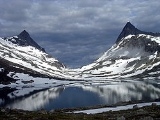
Årdal is a modern industrial community, with ties to the old society of farming and fishing. It is surrounded by dramatic nature with high mountain
s and waterfall
s. The climate is rather mild and with less rain than normal in the west part of Norway. Årdal is a good starting point to explore the wild nature of the national park Jotunheimen, and with summer and winter activities within its boundaries. The Vettisfossen
waterfall (highest in Norway) is located within the municipality.
The group called Årdal Sogelag concerns itself with local history and serves as an information service for people with connections to Årdal.
was established as a municipality on 1 January 1838 (see formannskapsdistrikt
). The original municipality was identical to the Lærdal parish
(prestegjeld
) including the sub-parish (sokn) of Aardal. In 1863, the sub-parish of Aardal (population: 1,791) was separated from Lærdal
and became a municipality of its own. The spelling was later changed to Årdal. On 1 January 1964, the Muggeteigen, Luggenes, and Bergmål farms (population: 11) were transferred from Årdal to Lærdal
.
form of the name was Árdalr. The first element is the genitive case of á which means "river" (referring to the Utla river) and the last element is dalr which means "valley" or "dale". Until 1921 the name was written Aardal.
was granted on 9 August 1957. The local economy at the time was mainly based on heavy industry
, which needs a lot of electricity. The zig-zag lines in the arms symbolize both the electrical power
and the industries
. The colors were chosen randomly.
has two churches within the municipality of Årdal. It is part of the Diocese of Bjørgvin
and the Rural Deanery
(Prosti) of Indre Sogn
.
(through 10th grade), outpatient health services
, senior citizen
services, unemployment
and other social services
, zoning
, economic development
, and municipal road
s. The municipality is governed by a municipal council of elected representatives, which in turn elect a mayor
.
breakdown is as follows:
(ordførar) of a municipality in Norway is a representative of the majority party of the municipal council who is elected to lead the council. Arild Ingar Lægreid of the Labour Party
(Det Norske Arbeiderpartiet) was elected mayor for the 2007–2011 term.
 The municipality is situated at the beginning of the Sognefjord
and is a gateway to the mountain areas called Jotunheimen
and Hurrungane
, including the mountains Falketind
, Store Austanbotntind
, and Store Skagastølstind
.
There are two urban areas in Årdal: Årdalstangen
and Øvre Årdal
, with a total population of approximately 5,700. There are also smaller village areas throughout the municipality: Naddvik (Vikadalen), Nundalen, Indre Offerdal
, Ytre Offerdal, Seimsdalen
, Fardalen
, Avdalen
, Utladalen, Vetti
, and Vettismorki
.
Årdal is bordered to the north and west by the municipality of Luster
, to the east by Vang (in Oppland
county), and to the south by Lærdal
.
. In the course of a few years, Årdal was transformed from a scarcely populated rural community into a small town situated around the aluminium
plant Årdal og Sunndal Verk
. Construction of the aluminium plant at Årdal started in 1941. The purpose was to build a large aluminium industry as a part of the German war effort. The Norwegian State confiscated the unfinished plant in Årdal in 1945 at the end of the war. The plant was finished by the government and production started in 1948.
At Årdal, the aluminium factory produced semi-finished aluminium that went on to be transformed into various products in other factories. During the early years most of the aluminium was exported. The car and airplane industries were big aluminium consumers. Some finished products were made in Norway
, such as Høyang kitchen equipment, kettles, and pans.
In 1986, Årdal og Sunndal Verk
was merged with Norsk Hydro
under the name Hydro Aluminium AS.
waterfall was given protected status in 1924. With a free fall of 275 metres (902.2 ft), it is the highest waterfall in Northern Europe
.
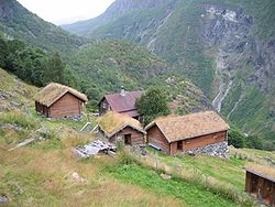
The Vetti Gard og Turiststasjon
, a farm rich in tradition dating from around 1120, is set in dramatic natural surroundings. The farm has been involved in tourism ever since the early 19th century and now serves as a café and tourist information office in the summer. The Vettismorki
mountain farm is located nearby.
The Utladalen Landscape Protection Area
(314 square kilometres (121.2 sq mi)) was established in conjunction with the Jotunheimen National Park. It comprises large parts of the Utladalen valey and adjoining side valleys. The area contains several old farms and mountain pasture farmsteads of historical interest.
Utladalen Naturhus is a nature center situated at Skåri, an old farm. Farming here ceased in the early 1970s. In 1996 work commenced on the restoration of the old cultural landscape, and the Utladalen Naturhus center was opened in May 1998. Run by the Utladalen Naturhus foundation, the aim of the centre is to inform visitors about the natural and cultural history of Utladalen and Western Jotunheimen
. The centre also includes the Slingsby Museum.
 The Avdalen farm is scenically situated on the mountainside above the beautiful Avdalen
waterfall in the Utladalen valley. The land was cleared for farming in the 16th century. Abandoned in more recent times, the farm has now been restored to provide restaurant, accommodation and meeting facilities. The mill house can be seen in operation milling grain.
, Fannaråki
, and the Rauddalstind og Mjølkedalstind peaks. Jotunheimen
is a popular area for hiking in summer and skiing in winter, and the Hurrungane
massif
is very popular with climbers.
"right down by the shore" is packed with interesting history about Årdal. Ten buildings, including a mill, sawmill, a shoreside warehouse, and farm buildings dating from the 19th century, provide insight into the beginnings of the extensive industrialization of this local community.
Counties of Norway
Norway is divided into 19 administrative regions, called counties . The counties form the primary first-level subdivisions of Norway and are further divided into 430 municipalities...
of Sogn og Fjordane
Sogn og Fjordane
is a county in Norway, bordering Møre og Romsdal, Oppland, Buskerud, and Hordaland. The county administration is in the town of Hermansverk in Leikanger municipality while the largest town is Førde....
, Norway
Norway
Norway , officially the Kingdom of Norway, is a Nordic unitary constitutional monarchy whose territory comprises the western portion of the Scandinavian Peninsula, Jan Mayen, and the Arctic archipelago of Svalbard and Bouvet Island. Norway has a total area of and a population of about 4.9 million...
. It is located in the traditional district
Districts of Norway
The country Norway is historically divided into a number of districts. Many districts have deep historical roots, and only partially coincide with today's administrative units of counties and municipalities. The districts are defined by geographical features, often valleys, mountain ranges, fjords,...
of Sogn
Sogn
Sogn is a traditional district in Western Norway . It is located in the county of Sogn og Fjordane, surrounding the Sognefjord. Sogn consists of the municipalities of Aurland, Balestrand, Hyllestad, Høyanger, Gulen, Leikanger, Luster, Lærdal, Sogndal, Solund, Vik, and Årdal. The district covers ...
. The village of Årdalstangen
Årdalstangen
Årdalstangen is a village in the municipality Årdal in Sogn og Fjordane county, Norway. Årdalstangen is the administrative center of the municipality of Årdal, and it is one of the two main population centers in the municipality, along with Øvre Årdal. The village has a population of 1,515...
is the administrative center of the municipality. Årdal was separated from Lærdal
Lærdal
Lærdal is a municipality in the southwestern part of Sogn og Fjordane county, Norway. It is part of the traditional district of Sogn. The administrative center of the municipality is the village of Lærdalsøyri...
in 1860.
Årdal is a modern industrial community, with ties to the old society of farming and fishing. It is surrounded by dramatic nature with high mountain
Mountain
Image:Himalaya_annotated.jpg|thumb|right|The Himalayan mountain range with Mount Everestrect 58 14 160 49 Chomo Lonzorect 200 28 335 52 Makalurect 378 24 566 45 Mount Everestrect 188 581 920 656 Tibetan Plateaurect 250 406 340 427 Rong River...
s and waterfall
Waterfall
A waterfall is a place where flowing water rapidly drops in elevation as it flows over a steep region or a cliff.-Formation:Waterfalls are commonly formed when a river is young. At these times the channel is often narrow and deep. When the river courses over resistant bedrock, erosion happens...
s. The climate is rather mild and with less rain than normal in the west part of Norway. Årdal is a good starting point to explore the wild nature of the national park Jotunheimen, and with summer and winter activities within its boundaries. The Vettisfossen
Vettisfossen
Vettisfossen is one of Norway's tallest waterfalls, and the 284th tallest in the world. It is located in the Jotunheimen mountain range inside the Utladalen Landscape Protection Area in the municipality of Årdal in Sogn og Fjordane county, Norway. The waterfall has a single drop of...
waterfall (highest in Norway) is located within the municipality.
The group called Årdal Sogelag concerns itself with local history and serves as an information service for people with connections to Årdal.
General information
LærdalLærdal
Lærdal is a municipality in the southwestern part of Sogn og Fjordane county, Norway. It is part of the traditional district of Sogn. The administrative center of the municipality is the village of Lærdalsøyri...
was established as a municipality on 1 January 1838 (see formannskapsdistrikt
Formannskapsdistrikt
Formannskapsdistrikt was the name for a Norwegian local self-government districts put into force in 1838. This system of municipality was created in a bill approved by the Storting and signed into law by King Carl Johan on 14 January 1837...
). The original municipality was identical to the Lærdal parish
Church of Norway
The Church of Norway is the state church of Norway, established after the Lutheran reformation in Denmark-Norway in 1536-1537 broke the ties to the Holy See. The church confesses the Lutheran Christian faith...
(prestegjeld
Prestegjeld
A Prestegjeld is a geographic and administrative area of the Church of Norway roughly equivalent to a parish. A prestegjeld can consist of one or many congregations...
) including the sub-parish (sokn) of Aardal. In 1863, the sub-parish of Aardal (population: 1,791) was separated from Lærdal
Lærdal
Lærdal is a municipality in the southwestern part of Sogn og Fjordane county, Norway. It is part of the traditional district of Sogn. The administrative center of the municipality is the village of Lærdalsøyri...
and became a municipality of its own. The spelling was later changed to Årdal. On 1 January 1964, the Muggeteigen, Luggenes, and Bergmål farms (population: 11) were transferred from Årdal to Lærdal
Lærdal
Lærdal is a municipality in the southwestern part of Sogn og Fjordane county, Norway. It is part of the traditional district of Sogn. The administrative center of the municipality is the village of Lærdalsøyri...
.
Name
The Old NorseOld Norse
Old Norse is a North Germanic language that was spoken by inhabitants of Scandinavia and inhabitants of their overseas settlements during the Viking Age, until about 1300....
form of the name was Árdalr. The first element is the genitive case of á which means "river" (referring to the Utla river) and the last element is dalr which means "valley" or "dale". Until 1921 the name was written Aardal.
Coat-of-arms
The coat-of-armsCoat of arms
A coat of arms is a unique heraldic design on a shield or escutcheon or on a surcoat or tabard used to cover and protect armour and to identify the wearer. Thus the term is often stated as "coat-armour", because it was anciently displayed on the front of a coat of cloth...
was granted on 9 August 1957. The local economy at the time was mainly based on heavy industry
Heavy industry
Heavy industry does not have a single fixed meaning as compared to light industry. It can mean production of products which are either heavy in weight or in the processes leading to their production. In general, it is a popular term used within the name of many Japanese and Korean firms, meaning...
, which needs a lot of electricity. The zig-zag lines in the arms symbolize both the electrical power
Electric power
Electric power is the rate at which electric energy is transferred by an electric circuit. The SI unit of power is the watt.-Circuits:Electric power, like mechanical power, is represented by the letter P in electrical equations...
and the industries
Industry
Industry refers to the production of an economic good or service within an economy.-Industrial sectors:There are four key industrial economic sectors: the primary sector, largely raw material extraction industries such as mining and farming; the secondary sector, involving refining, construction,...
. The colors were chosen randomly.
Churches
The Church of NorwayChurch of Norway
The Church of Norway is the state church of Norway, established after the Lutheran reformation in Denmark-Norway in 1536-1537 broke the ties to the Holy See. The church confesses the Lutheran Christian faith...
has two churches within the municipality of Årdal. It is part of the Diocese of Bjørgvin
Diocese of Bjørgvin
Bjørgvin Diocese is a diocese in the Church of Norway. It covers churches located in the counties of Hordaland and Sogn og Fjordane. The cathedral city is Bergen. Bergen Cathedral, formerly the Church of Saint Olaf, serves as the seat of the presiding Bishop...
and the Rural Deanery
Deanery
A Deanery is an ecclesiastical entity in both the Roman Catholic Church and the Church of England. A deanery is either the jurisdiction or residence of a Dean.- Catholic usage :...
(Prosti) of Indre Sogn
Sogn
Sogn is a traditional district in Western Norway . It is located in the county of Sogn og Fjordane, surrounding the Sognefjord. Sogn consists of the municipalities of Aurland, Balestrand, Hyllestad, Høyanger, Gulen, Leikanger, Luster, Lærdal, Sogndal, Solund, Vik, and Årdal. The district covers ...
.
| Parish (Prestegjeld) | Sub-Parish (Sogn) | Church Name | Year Built | Location of the Church |
|---|---|---|---|---|
| Årdal Parish | Nedre Årdal | Årdal kyrkje | 1867 | Årdalstangen Årdalstangen Årdalstangen is a village in the municipality Årdal in Sogn og Fjordane county, Norway. Årdalstangen is the administrative center of the municipality of Årdal, and it is one of the two main population centers in the municipality, along with Øvre Årdal. The village has a population of 1,515... |
| Øvre Årdal | Farnes kyrkje | 1970 | Øvre Årdal Øvre Årdal Øvre Årdal is a village in the municipality of Årdal in Sogn og Fjordane county, Norway. It is the larger of the two primary villages in Årdal. The village is situated at the northern end of the long lake Årdalsvatnet, with the village of Årdalstangen at the southern end... |
|
| *In 1970, the Årdal sokn was split into Øvre Årdal and Nedre Årdal. | ||||
Government
All municipalities in Norway, including Årdal, are responsible for primary educationPrimary education
A primary school is an institution in which children receive the first stage of compulsory education known as primary or elementary education. Primary school is the preferred term in the United Kingdom and many Commonwealth Nations, and in most publications of the United Nations Educational,...
(through 10th grade), outpatient health services
Health care
Health care is the diagnosis, treatment, and prevention of disease, illness, injury, and other physical and mental impairments in humans. Health care is delivered by practitioners in medicine, chiropractic, dentistry, nursing, pharmacy, allied health, and other care providers...
, senior citizen
Old age
Old age consists of ages nearing or surpassing the average life span of human beings, and thus the end of the human life cycle...
services, unemployment
Unemployment
Unemployment , as defined by the International Labour Organization, occurs when people are without jobs and they have actively sought work within the past four weeks...
and other social services
Social work
Social Work is a professional and academic discipline that seeks to improve the quality of life and wellbeing of an individual, group, or community by intervening through research, policy, community organizing, direct practice, and teaching on behalf of those afflicted with poverty or any real or...
, zoning
Zoning
Zoning is a device of land use planning used by local governments in most developed countries. The word is derived from the practice of designating permitted uses of land based on mapped zones which separate one set of land uses from another...
, economic development
Economic development
Economic development generally refers to the sustained, concerted actions of policymakers and communities that promote the standard of living and economic health of a specific area...
, and municipal road
Road
A road is a thoroughfare, route, or way on land between two places, which typically has been paved or otherwise improved to allow travel by some conveyance, including a horse, cart, or motor vehicle. Roads consist of one, or sometimes two, roadways each with one or more lanes and also any...
s. The municipality is governed by a municipal council of elected representatives, which in turn elect a mayor
Mayor
In many countries, a Mayor is the highest ranking officer in the municipal government of a town or a large urban city....
.
Municipal council
The municipal council (Kommunestyre) of Årdal is made up of 21 representatives that are elected to every four years. For 2007–2011, the partyPolitical party
A political party is a political organization that typically seeks to influence government policy, usually by nominating their own candidates and trying to seat them in political office. Parties participate in electoral campaigns, educational outreach or protest actions...
breakdown is as follows:
Mayor
The mayorMayor
In many countries, a Mayor is the highest ranking officer in the municipal government of a town or a large urban city....
(ordførar) of a municipality in Norway is a representative of the majority party of the municipal council who is elected to lead the council. Arild Ingar Lægreid of the Labour Party
Norwegian Labour Party
The Labour Party is a social-democratic political party in Norway. It is the senior partner in the current Norwegian government as part of the Red-Green Coalition, and its leader, Jens Stoltenberg, is the current Prime Minister of Norway....
(Det Norske Arbeiderpartiet) was elected mayor for the 2007–2011 term.
Geography
Sognefjord
The Sognefjord is the largest fjord in Norway, and the second longest in the world. Located in Sogn og Fjordane county, it stretches inland to the small village of Skjolden...
and is a gateway to the mountain areas called Jotunheimen
Jotunheimen
Jotunheimen is a mountainous area of roughly 3,500 km² in Southern Norway and is part of the long range known as the Scandinavian Mountains. The 29 highest mountains in Norway are all in Jotunheimen, including the very highest - Galdhøpiggen...
and Hurrungane
Hurrungane
Hurrungane is a mountain range in the municipalities Luster and Årdal in Sogn og Fjordane, Norway...
, including the mountains Falketind
Falketind
Falketind is a mountain in the municipality of Årdal in Sogn og Fjordane county, Norway. It is located in the Jotunheimen mountain range inside the Utladalen Landscape Protection Area. The mountain is east of the old mountain farm, Vettismorki, and northwest of the lake Tyin.The 1820 ascent was...
, Store Austanbotntind
Store Austanbotntind
Store Austanbotntind is a mountain on the border of the municipalities of Luster and Årdal in Sogn og Fjordane county, Norway. It is the highest peak in the western part of the Hurrungane mountain range. The mountain is located in Jotunheimen National Park, about southeast of the village of...
, and Store Skagastølstind
Store Skagastølstind
Store Skagastølstind is the third highest peak in Norway. It is situated on the border between the municipality of Luster and Årdal in Sogn og Fjordane county, Norway. The mountain is part of the Hurrungane range...
.
There are two urban areas in Årdal: Årdalstangen
Årdalstangen
Årdalstangen is a village in the municipality Årdal in Sogn og Fjordane county, Norway. Årdalstangen is the administrative center of the municipality of Årdal, and it is one of the two main population centers in the municipality, along with Øvre Årdal. The village has a population of 1,515...
and Øvre Årdal
Øvre Årdal
Øvre Årdal is a village in the municipality of Årdal in Sogn og Fjordane county, Norway. It is the larger of the two primary villages in Årdal. The village is situated at the northern end of the long lake Årdalsvatnet, with the village of Årdalstangen at the southern end...
, with a total population of approximately 5,700. There are also smaller village areas throughout the municipality: Naddvik (Vikadalen), Nundalen, Indre Offerdal
Indre Offerdal
Indre Offerdal is a small village on the shore of the Årdalsfjord in the municipality of Årdal in Sogn og Fjordane, Norway. It was the administrative center of the municipality of Årdal more than 100 years ago. In those days, the main industry in Årdal was lumber, and Indre Offerdal had a...
, Ytre Offerdal, Seimsdalen
Seimsdalen
Seimsdalen is a valley in the municipality of Årdal in Sogn og Fjordane county, Norway. The valley is located west of the municipal center of Årdalstangen, to which it is connected via a long tunnel. The village of Indre Offerdal lies about to the southwest. The population of the valley is 433....
, Fardalen
Fardalen
Fardalen is a valley stretching northwest from the village of Øvre Årdal in the municipality of Årdal in Sogn og Fjordane county, Norway. The valley branches off of the main Utladalen valley. The road with the highest elevation in Norway has its path through this valley, reaching more than above...
, Avdalen
Avdalen
Avdalen is a small side valley of the main Utladalen valley in the municipality of Årdal in Sogn og Fjordane county, Norway. It is located within the Utladalen Landscape Protection Area, which was established along with the adjacent Jotunheim National Park in 1980 and covers about...
, Utladalen, Vetti
Vetti, Sogn og Fjordane
Vetti is an old farm area in the Utladalen valley in the municipality of Årdal in Sogn og Fjordane county, Norway. It located northeast of Øvre Årdal, along the Utla river and has likely been inhabited since 1120. From Vetti, there are two walking paths into the Utladalen Landscape Protection...
, and Vettismorki
Vettismorki
Vettismorki is an old mountain farm located just above the waterfall Vettisfossen in the Utladalen valley in the municipality of Årdal, Sogn og Fjordane county, Norway. It is north of the Vetti farm, and northeast of the village of Øvre Årdal...
.
Årdal is bordered to the north and west by the municipality of Luster
Luster, Norway
Luster is a municipality in the county of Sogn og Fjordane, Norway. It is located in the traditional district of Sogn. The administrative centre is Gaupne. Other villages include Skjolden, Hafslo, Jostedal, and Veitastrond....
, to the east by Vang (in Oppland
Oppland
is a county in Norway, bordering Sør-Trøndelag, Møre og Romsdal, Sogn og Fjordane, Buskerud, Akershus, Oslo and Hedmark. The county administration is in Lillehammer. Oppland is, together with Hedmark, one of the only two landlocked counties of Norway....
county), and to the south by Lærdal
Lærdal
Lærdal is a municipality in the southwestern part of Sogn og Fjordane county, Norway. It is part of the traditional district of Sogn. The administrative center of the municipality is the village of Lærdalsøyri...
.
Industry
Årdal became a symbol of modern Norway after World War IIWorld War II
World War II, or the Second World War , was a global conflict lasting from 1939 to 1945, involving most of the world's nations—including all of the great powers—eventually forming two opposing military alliances: the Allies and the Axis...
. In the course of a few years, Årdal was transformed from a scarcely populated rural community into a small town situated around the aluminium
Aluminium
Aluminium or aluminum is a silvery white member of the boron group of chemical elements. It has the symbol Al, and its atomic number is 13. It is not soluble in water under normal circumstances....
plant Årdal og Sunndal Verk
Årdal og Sunndal Verk
Årdal og Sunndal Verk or ÅSV is a defunct Norwegian state owned company that operated the aluminum plants in Årdal, Sunndal, Høyanger and Holmestrand. The company was established to take advantage of the hydro-electric power plants in the respective villages to create aluminum plants...
. Construction of the aluminium plant at Årdal started in 1941. The purpose was to build a large aluminium industry as a part of the German war effort. The Norwegian State confiscated the unfinished plant in Årdal in 1945 at the end of the war. The plant was finished by the government and production started in 1948.
At Årdal, the aluminium factory produced semi-finished aluminium that went on to be transformed into various products in other factories. During the early years most of the aluminium was exported. The car and airplane industries were big aluminium consumers. Some finished products were made in Norway
Norway
Norway , officially the Kingdom of Norway, is a Nordic unitary constitutional monarchy whose territory comprises the western portion of the Scandinavian Peninsula, Jan Mayen, and the Arctic archipelago of Svalbard and Bouvet Island. Norway has a total area of and a population of about 4.9 million...
, such as Høyang kitchen equipment, kettles, and pans.
In 1986, Årdal og Sunndal Verk
Årdal og Sunndal Verk
Årdal og Sunndal Verk or ÅSV is a defunct Norwegian state owned company that operated the aluminum plants in Årdal, Sunndal, Høyanger and Holmestrand. The company was established to take advantage of the hydro-electric power plants in the respective villages to create aluminum plants...
was merged with Norsk Hydro
Norsk Hydro
Norsk Hydro ASA is a Norwegian aluminium and renewable energy company, headquartered in Oslo. Hydro is the fourth largest integrated aluminium company worldwide. It has operations in some 40 countries around the world and is active on all continents. The Norwegian state holds a 43.8 percent...
under the name Hydro Aluminium AS.
Utladalen
The VettisfossenVettisfossen
Vettisfossen is one of Norway's tallest waterfalls, and the 284th tallest in the world. It is located in the Jotunheimen mountain range inside the Utladalen Landscape Protection Area in the municipality of Årdal in Sogn og Fjordane county, Norway. The waterfall has a single drop of...
waterfall was given protected status in 1924. With a free fall of 275 metres (902.2 ft), it is the highest waterfall in Northern Europe
Northern Europe
Northern Europe is the northern part or region of Europe. Northern Europe typically refers to the seven countries in the northern part of the European subcontinent which includes Denmark, Estonia, Latvia, Lithuania, Norway, Finland and Sweden...
.
The Vetti Gard og Turiststasjon
Vetti, Sogn og Fjordane
Vetti is an old farm area in the Utladalen valley in the municipality of Årdal in Sogn og Fjordane county, Norway. It located northeast of Øvre Årdal, along the Utla river and has likely been inhabited since 1120. From Vetti, there are two walking paths into the Utladalen Landscape Protection...
, a farm rich in tradition dating from around 1120, is set in dramatic natural surroundings. The farm has been involved in tourism ever since the early 19th century and now serves as a café and tourist information office in the summer. The Vettismorki
Vettismorki
Vettismorki is an old mountain farm located just above the waterfall Vettisfossen in the Utladalen valley in the municipality of Årdal, Sogn og Fjordane county, Norway. It is north of the Vetti farm, and northeast of the village of Øvre Årdal...
mountain farm is located nearby.
The Utladalen Landscape Protection Area
Utladalen Landscape Protection Area
Utladalen Landscape Protection Area is adjacent to Jotunheimen National Park, covering Utladalen, Norway's deepest valley. It is located about northeast of Øvre Årdal in the municipality of Årdal in Sogn og Fjordane, Norway....
(314 square kilometres (121.2 sq mi)) was established in conjunction with the Jotunheimen National Park. It comprises large parts of the Utladalen valey and adjoining side valleys. The area contains several old farms and mountain pasture farmsteads of historical interest.
Utladalen Naturhus is a nature center situated at Skåri, an old farm. Farming here ceased in the early 1970s. In 1996 work commenced on the restoration of the old cultural landscape, and the Utladalen Naturhus center was opened in May 1998. Run by the Utladalen Naturhus foundation, the aim of the centre is to inform visitors about the natural and cultural history of Utladalen and Western Jotunheimen
Jotunheimen
Jotunheimen is a mountainous area of roughly 3,500 km² in Southern Norway and is part of the long range known as the Scandinavian Mountains. The 29 highest mountains in Norway are all in Jotunheimen, including the very highest - Galdhøpiggen...
. The centre also includes the Slingsby Museum.
Avdalen Gård (Farm)
Avdalen
Avdalen is a small side valley of the main Utladalen valley in the municipality of Årdal in Sogn og Fjordane county, Norway. It is located within the Utladalen Landscape Protection Area, which was established along with the adjacent Jotunheim National Park in 1980 and covers about...
waterfall in the Utladalen valley. The land was cleared for farming in the 16th century. Abandoned in more recent times, the farm has now been restored to provide restaurant, accommodation and meeting facilities. The mill house can be seen in operation milling grain.
Jotunheimen National Park
The Jotunheimen National Park, established in 1980, covers an area of approximately 1145 square kilometres (442.1 sq mi) and comprises the HurrunganeHurrungane
Hurrungane is a mountain range in the municipalities Luster and Årdal in Sogn og Fjordane, Norway...
, Fannaråki
Fannaråki
Fannaråki is a mountain in the municipality of Luster in Sogn og Fjordane county, Norway. The tall mountain is located in the Jotunheimen National Park, just south of the lake Prestesteinsvatnet and the Sognefjellsvegen road...
, and the Rauddalstind og Mjølkedalstind peaks. Jotunheimen
Jotunheimen
Jotunheimen is a mountainous area of roughly 3,500 km² in Southern Norway and is part of the long range known as the Scandinavian Mountains. The 29 highest mountains in Norway are all in Jotunheimen, including the very highest - Galdhøpiggen...
is a popular area for hiking in summer and skiing in winter, and the Hurrungane
Hurrungane
Hurrungane is a mountain range in the municipalities Luster and Årdal in Sogn og Fjordane, Norway...
massif
Massif
In geology, a massif is a section of a planet's crust that is demarcated by faults or flexures. In the movement of the crust, a massif tends to retain its internal structure while being displaced as a whole...
is very popular with climbers.
Indre Offerdal Museum
This old fjord-side settlement of Indre OfferdalIndre Offerdal
Indre Offerdal is a small village on the shore of the Årdalsfjord in the municipality of Årdal in Sogn og Fjordane, Norway. It was the administrative center of the municipality of Årdal more than 100 years ago. In those days, the main industry in Årdal was lumber, and Indre Offerdal had a...
"right down by the shore" is packed with interesting history about Årdal. Ten buildings, including a mill, sawmill, a shoreside warehouse, and farm buildings dating from the 19th century, provide insight into the beginnings of the extensive industrialization of this local community.
Scenic Views
- Mountain Road from Årdal-Turtagrø: In the summer, this road from Øvre ÅrdalØvre ÅrdalØvre Årdal is a village in the municipality of Årdal in Sogn og Fjordane county, Norway. It is the larger of the two primary villages in Årdal. The village is situated at the northern end of the long lake Årdalsvatnet, with the village of Årdalstangen at the southern end...
to TurtagrøTurtagrøTurtagrø is a hotel in the municipality of Luster in Sogn og Fjordane county, Norway, near Hurrungane in Jotunheimen. The hotel has been a central meeting place for mountaineers from the late 1800s.-Location:...
links Årdal to the Sognefjell mountain roadSognefjellsvegenThe Sognefjellsvegen or Sognefjellsveien is the highest mountain pass road in Northern Europe. It is located in Oppland and Sogn og Fjordane counties in Norway. It is a national tourist road and starts in the village of Lom in the municipality of Lom, it then travels over the Sognefjell mountain...
. On the drive across you will enjoy spectacular views of breath-taking scenery.
- Folkevegen road from Hjelle-Vetti: From VettiVetti, Sogn og FjordaneVetti is an old farm area in the Utladalen valley in the municipality of Årdal in Sogn og Fjordane county, Norway. It located northeast of Øvre Årdal, along the Utla river and has likely been inhabited since 1120. From Vetti, there are two walking paths into the Utladalen Landscape Protection...
you can walk to EuropeEuropeEurope is, by convention, one of the world's seven continents. Comprising the westernmost peninsula of Eurasia, Europe is generally 'divided' from Asia to its east by the watershed divides of the Ural and Caucasus Mountains, the Ural River, the Caspian and Black Seas, and the waterways connecting...
's highest waterfall (275 metres (902.2 ft) high). The road/path leads through beautiful scenery and passes four waterfalls.