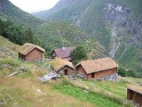
Avdalen
Encyclopedia
Avdalen is a small side valley of the main Utladalen valley in the municipality of Årdal
in Sogn og Fjordane
county, Norway
. It is located within the Utladalen Landscape Protection Area
, which was established along with the adjacent Jotunheim National Park
in 1980 and covers about 300 square kilometres (115.8 sq mi). A blues concert is held at Avdalen each year in June—it has become increasingly popular.
The Årdal mountain touring club maintains a staffed lodge at the former Avdal farm (Avdalen gård). The Avdal farm was first occupied in 16th century and was vacated in 1962. The farm is located above the magnificent Avdalsfossen waterfall, about 3 kilometres (1.9 mi) south of Vetti
. The farm has undergone a restoration, and currently provides meals as well as accommodation for tourists. It can be reached by a 2 kilometres (1.2 mi) car ride from Øvre Årdal
to Hjelle, followed by a 45-minute hike. The last part of the hike is very steep and illustrates the challenge of daily life for the former residents.
Årdal
Årdal is a municipality in the county of Sogn og Fjordane, Norway. It is located in the traditional district of Sogn. The village of Årdalstangen is the administrative center of the municipality. Årdal was separated from Lærdal in 1860....
in Sogn og Fjordane
Sogn og Fjordane
is a county in Norway, bordering Møre og Romsdal, Oppland, Buskerud, and Hordaland. The county administration is in the town of Hermansverk in Leikanger municipality while the largest town is Førde....
county, Norway
Norway
Norway , officially the Kingdom of Norway, is a Nordic unitary constitutional monarchy whose territory comprises the western portion of the Scandinavian Peninsula, Jan Mayen, and the Arctic archipelago of Svalbard and Bouvet Island. Norway has a total area of and a population of about 4.9 million...
. It is located within the Utladalen Landscape Protection Area
Utladalen Landscape Protection Area
Utladalen Landscape Protection Area is adjacent to Jotunheimen National Park, covering Utladalen, Norway's deepest valley. It is located about northeast of Øvre Årdal in the municipality of Årdal in Sogn og Fjordane, Norway....
, which was established along with the adjacent Jotunheim National Park
Jotunheim National Park
Jotunheimen National Park is a national park in Norway, recognized as one of the country's premier hiking and fishing regions. The national park covers 1,151 km² and is part of the larger area Jotunheimen...
in 1980 and covers about 300 square kilometres (115.8 sq mi). A blues concert is held at Avdalen each year in June—it has become increasingly popular.
The Årdal mountain touring club maintains a staffed lodge at the former Avdal farm (Avdalen gård). The Avdal farm was first occupied in 16th century and was vacated in 1962. The farm is located above the magnificent Avdalsfossen waterfall, about 3 kilometres (1.9 mi) south of Vetti
Vetti, Sogn og Fjordane
Vetti is an old farm area in the Utladalen valley in the municipality of Årdal in Sogn og Fjordane county, Norway. It located northeast of Øvre Årdal, along the Utla river and has likely been inhabited since 1120. From Vetti, there are two walking paths into the Utladalen Landscape Protection...
. The farm has undergone a restoration, and currently provides meals as well as accommodation for tourists. It can be reached by a 2 kilometres (1.2 mi) car ride from Øvre Årdal
Øvre Årdal
Øvre Årdal is a village in the municipality of Årdal in Sogn og Fjordane county, Norway. It is the larger of the two primary villages in Årdal. The village is situated at the northern end of the long lake Årdalsvatnet, with the village of Årdalstangen at the southern end...
to Hjelle, followed by a 45-minute hike. The last part of the hike is very steep and illustrates the challenge of daily life for the former residents.
External links
- Map of the Utladalen Landscape Protection Area and the adjacent Jotunheim National Park (Avdalen is marked near the bottom)
- Picture of the Avdal Farm

