
Xining
Encyclopedia
Xining is the capital of Qinghai
province, People's Republic of China
, and the largest city on the Tibetan Plateau
. It has 2,208,708 inhabitants at the 2010 census whom 1,198,304 live in the built up area made of 4 urban districts.
.jpg) Xining has a history of over 2100 years and was a chief commercial hub on the Hexi Corridor
Xining has a history of over 2100 years and was a chief commercial hub on the Hexi Corridor
caravan route to Tibet
, handling especially timber, wool and salt in ancient times. The trade along the Hexi Corridor was part of a larger trade corridor along the Northern Silk Road
, whose use was intensified in the first century BC after efforts by the Han Dynasty
to control this route.
Under the Han dynasty (206 BC–AD 220) a county there called Linqiang controlled the local Qiang tribesmen. It was again a frontier county under the Sui
(581–618) and Tang
(618–907) dynasties; during the 7th and early 8th centuries it was a center of constant warfare with the Tuyuhun and (later) the Tibetan people
s. In 763 it was overrun by the Tibetans and while under Tibetan control was known to the Chinese as Qingtangcheng. Recovered by the Song dynasty
in 1104, it received the name Xining (meaning "peace in the west") and has been the seat of a prefecture or superior prefecture under that name since that time. With the rise of Tibetan Buddhism
(Lamaism), which began in the 7th century AD, Xining became an important religious center; Qinghai's largest lamasery, a holy place to the Yellow Hat sect of Buddhists, was located at Kunbum, some 19 km to the southeast.
A major earthquake occurred May 22, 1927 and measured 8.6 on Richter scale
. It was one of the deadliest earthquakes with a total count of 200,000 deaths. It also caused large land fractures.
Xining was the extraterritorial capital of the Koko Nor territory and remained in Gansu
until 1928, when it became the provincial capital of the newly established independent province of Qinghai. Xining was given municipal status in 1945.
Under Governor 1928's reign, Xining, like the rest of Qinghai, underwent industrialization and modernization. In 1947 the USA sold Ma Bufang a piped water (sewage) system which was installed in Xining. Ma Bufang also promoted education. He made businessmen methodically clean up Xining by serving as insect exterminators, killing flies and neatly throwing them away.
Since the late 1950s, when the Liujia Gorge Dam and hydroelectric project came into operation in neighboring Gansu province, Xining has been linked by a high-tension electrical grid to both Liujia and Lanzhou. It also uses local coal
from mines at Datongxian to the north. A modern woolen mill was installed at Xining before 1957. The city also has a leather industry and is a market for salt from the Qaidam
region. During the late 1950s medium-sized iron and steelworks were built there, supplying metal to Lanzhou.
Construction of a highway to the mineral-rich Qaidam
basin and completion in 1959 of a link to the Chinese rail network via Lanzhou
in Gansu province has spurred industrial development. This effort was part of a plan of the central government to rapidly exploit oil and pasturage in the Xining area beginning in the 1950s.
 Xining is located in the eastern part of Qinghai
Province and lies on the Huangshui River. It has a total area of 350 km².
Xining is located on the eastern edge of the Qinghai-Tibet Plateau and the upper reaches of the Huangshui River. It is the political, economic, and cultural center of Qinghai Province with an average altitude of about 2200 metres (7,217.8 ft). Human activity in the region can be traced to 2,100 years ago. During the Western and Eastern Han dynasties
, owing to its developing agriculture
, Xining was paid noticed due to its economic and military significance. As well as being an important hinge between the Central Plains and the western part of China in ancient times, Xining was an important link in the Silk Road
. It continues to be an important rail and road link to the hinterlands of the Qinghai-Tibet Plateau.
Xining has also been dubbed the Summer Resort Capital of China owing to its cool summer, with a cold semi-arid climate (Köppen
BSk). Conditions are influenced by the aridity and high altitude. Lows are cold or cool throughout the year, and highs are often more than 15 °C-change warmer than lows. Monthly daily averages range from −7.4 °C in January to 17.3 °C (63.1 °F) in July; the year averages at 6.1 °C (43 °F). Rainfall falls mainly from May to September, and the area is often dry and sunny, with nearly 2680 hours of bright sunshine per year.
lent US$1 billion to aid river treatment in Xining, including Sanxian County's anti-flooding project, with an added US$1 billion dollars to support infrastructure. Qinghai has invested large amounts in the treatment of Huangshui Main River and Nanchuan River, totalling 24.5 km. However, a treatment on a 40 kilometer river course and 10 flash flood relief channels remain pending due to lack of equipment. In Sanxian County, a 108.4 meter long river course and 80 flash flood relief channels need treatment.

per capita was ¥19,494 (ca. US$2,800) in 2008, ranked no. 382 among 659 Chinese cities. Its main industries are wool spinning and textiles, fur, meat, milk, salt, and light processing industries.
Xining Economic & Technological Development Zone (ZETDZ) was approved as state-level development zone in July 2000. It has a planned area of 4.4 square kilometers. XETDZ lies in the east of Xining, the capital city of Qinghai province, 5 kilometers away from downtown. Located in the east of the province, Xining stands at the upper reaches of the Huangshui River-one of the Yellow River's branches. The city is surrounded by the mountains with an average elevation of 2261 meters and the highest at 4393 meters. Xining Economic and Technological Development Zone (XETDZ) is the first of its kind at the national level on the Qinghai-Tibet Plateau. It is established to fulfill the nation's strategy of developing the west.
XETDZ enjoys a convenient transportation system, connected by the Xining-Lanzhou expressway and run through by two main roads, the broadest roads of the city. It is 4 kilometers away from the railway station, 15 kilometers from Xi'ning Airport, a grade 4D airport with 14 airlines to other cities such as Beijing, Guangzhou, Shanghai, Chengdu and Xi'an. Xi'ning is Qinghai province's passage to the outside world, a transportation center with more than ten highways, over one hundred roads and two railways, Lanzhou-Qinghai and Qinghai-Tibet Railways in and out of the city.
It focuses on the development of following industries: chemicals based on salt lake resources, nonferrous metals, and petroleum and natural gas processing; special medicine, foods and bio-chemicals using local plateau animals and plants; new products involving ecological and environmental protection, high technology, new materials as well as information technology; and services such as logistics, banking, real estate, tourism, hotel, catering, agency and international trade.
.jpg) According to the 2010 Census
According to the 2010 Census
, the prefecture-level city of Xining has a population of 2,208,708 inhabitants, 229,508 persons more than in 2000 (and the demographic growth for the period 2000-2010 was of 1.1% per year).
At present, four districts, three counties, and a national economic and technological development zone are under the administration of the local government. With a population of more than two million, Xining is the first city on the upper reaches of the Yellow River
to achieve a population in the millions. There are about 37 nationalities living here, though it is only the Han
, Hui
, Monguor (Tu people in Chinese - 土族) and Tibetan
who are numerically significant. Local traditions and customs are influenced by the Tibetans, Monguor, Muslims, and Han. On 2010 Census numbers, Han Chinese represent 74.04% of the total population of Xining, while Hui (16.26%), Tibetan (5.51%) and Tu (2.6%) are the main minority groups in the city
and counties
. The data here are presented in km² and in population according to 2010 Census:
 Xining is situated in a fertile mountain basin in the valley of the Huangshui (river), a tributary of the Yellow River, that acts as a river port. The city lies about 200 km west of Lanzhou
in Gansu
province, on what was traditionally the main trade route from northern China
into Tibet
and the Qaidam Basin. These routes are now followed by modern highway
s.
to the main Chinese system at Lanzhou; this railway extends into the Qaidam area via Haiyan
near Qinghai Lake
to Golmud
and extends, since 2006, to Lhasa
in Tibet
.
serves the area with regularly scheduled passenger flights to major Chinese cities including Beijing, Shanghai, Hong Kong, Chengdu, Kunming, Xi'an, and Wuhan.
or Ta'er Monastery is one of six famous monasteries in the Gelug
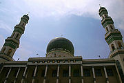
(also called Yellow Hat Sect) of Tibetan Buddhism. Having a history of over 600 years, the Dongguan Mosque, located in the Xining City Zone, is one of the most famous mosques in the northwest region of China. It has splendid and diversiform towers, walls and halls in the mosque. Another unique religious structure is the Beishan Si (North Mountain Temple), a Taoist facility.
 The Xining region is also replete with natural scenic attractions. One is the Sun and Moon Mountain which divides Qinghai Province into two parts - the stock-raising area and the farming area. Another not-to-be-missed destination is the Qinghai Lake
and Bird Island. This alluring body of water is home to hundreds of thousands of birds. About 35 kilometers west of Xining City in Datong County, you can experience the magical power of Laoye Mountain. Every year on the 6th day of the 6th lunar month, the traditional singing festival attracts hundreds of thousands of visitors.
 As the capital of Qinghai province, Xining almost boasts all varieties of local flavors. Xining's cuisine is distinct from other varieties of Chinese cities using mainly food products native to the area. Food here is substantial, but quite inexpensive.
A unique feature of dishes in Xining is that they are given names after the surname of their initiator. Here are some of the most famous: Liangfen
(bean jelly) is made from pea powder and cut into short strips. Liangfen is served with vinegar, chili and mashed garlic, mustard and salt to enhance the taste the dish. Niangpi is a popular snack made of flour and baking soda. It can be found anywhere in Xining for four-yuan. The most famous version of this snack is called Mazhong Niangpi and can be found in the Mojia Jie. Zasui Tang is a soup cooked with lamb and oxen entrails. Locals often eat this snack for breakfast. The hot soup helps warm people during the winter. Muslim Yoghurt is a must while in Xining – this breakfast is a kind of substance made by local Muslim families and is served in small bowls for one-yuan. Terrine is a popular snack in Xining. It is a small hot pot which contains beef, mutton, been curd and vermicelli. Mutton Eaten with Fingers is the most famous snack in Qinghai Province. It is made of fresh mutton and served with a little salt. This snack is the favorite food of the herdsmen of Qinghai Province.
In Xining, some restaurants serve varieties of 'plateau flavor', such as Feng'er Liji (a round lamb tenderloin), Danbai Chongcao Ji (a medicine cuisine made of chicken, Chinese caterpillar fungus and eggs), Jinyu Facai (pork wrapped in flagelliform nostoc
and shaped as a goldfish) among others. These dishes are often cooked by the locals at home.
There are also many small restaurants offering noodles. Gan Ban is a very common noodle dish. Perhaps Mian Pian, which means "noodle leaves" is the most common noodle plate among the Qinghai people.
On the streets, many Muslims sell spicy lamb brochettes.
Due to the cold climate, residents of Xining are also fond of strong spirits - Xining has the reputation of being one of the heaviest regions of alcohol consumption in China.
Qinghai
Qinghai ; Oirat Mongolian: ; ; Salar:) is a province of the People's Republic of China, named after Qinghai Lake...
province, People's Republic of China
People's Republic of China
China , officially the People's Republic of China , is the most populous country in the world, with over 1.3 billion citizens. Located in East Asia, the country covers approximately 9.6 million square kilometres...
, and the largest city on the Tibetan Plateau
Tibetan Plateau
The Tibetan Plateau , also known as the Qinghai–Tibetan Plateau is a vast, elevated plateau in Central Asia covering most of the Tibet Autonomous Region and Qinghai, in addition to smaller portions of western Sichuan, southwestern Gansu, and northern Yunnan in Western China and Ladakh in...
. It has 2,208,708 inhabitants at the 2010 census whom 1,198,304 live in the built up area made of 4 urban districts.
History
Hexi Corridor
Hexi Corridor or Gansu Corridor refers to the historical route in Gansu province of China. As part of the Northern Silk Road running northwest from the bank of the Yellow River, it was the most important route from North China to the Tarim Basin and Central Asia for traders and the military. The...
caravan route to Tibet
Tibet
Tibet is a plateau region in Asia, north-east of the Himalayas. It is the traditional homeland of the Tibetan people as well as some other ethnic groups such as Monpas, Qiang, and Lhobas, and is now also inhabited by considerable numbers of Han and Hui people...
, handling especially timber, wool and salt in ancient times. The trade along the Hexi Corridor was part of a larger trade corridor along the Northern Silk Road
Northern Silk Road
The Northern Silk Road is a prehistoric trackway in northern China originating in the early capital of Xi'an and extending north of the Taklamakan Desert to reach the ancient kingdoms of Parthia, Bactria and eventually Persia and Rome. It is the northern-most branch of several Silk Roads providing...
, whose use was intensified in the first century BC after efforts by the Han Dynasty
Han Dynasty
The Han Dynasty was the second imperial dynasty of China, preceded by the Qin Dynasty and succeeded by the Three Kingdoms . It was founded by the rebel leader Liu Bang, known posthumously as Emperor Gaozu of Han. It was briefly interrupted by the Xin Dynasty of the former regent Wang Mang...
to control this route.
Under the Han dynasty (206 BC–AD 220) a county there called Linqiang controlled the local Qiang tribesmen. It was again a frontier county under the Sui
Sui Dynasty
The Sui Dynasty was a powerful, but short-lived Imperial Chinese dynasty. Preceded by the Southern and Northern Dynasties, it ended nearly four centuries of division between rival regimes. It was followed by the Tang Dynasty....
(581–618) and Tang
Tang Dynasty
The Tang Dynasty was an imperial dynasty of China preceded by the Sui Dynasty and followed by the Five Dynasties and Ten Kingdoms Period. It was founded by the Li family, who seized power during the decline and collapse of the Sui Empire...
(618–907) dynasties; during the 7th and early 8th centuries it was a center of constant warfare with the Tuyuhun and (later) the Tibetan people
Tibetan people
The Tibetan people are an ethnic group that is native to Tibet, which is mostly in the People's Republic of China. They number 5.4 million and are the 10th largest ethnic group in the country. Significant Tibetan minorities also live in India, Nepal, and Bhutan...
s. In 763 it was overrun by the Tibetans and while under Tibetan control was known to the Chinese as Qingtangcheng. Recovered by the Song dynasty
Song Dynasty
The Song Dynasty was a ruling dynasty in China between 960 and 1279; it succeeded the Five Dynasties and Ten Kingdoms Period, and was followed by the Yuan Dynasty. It was the first government in world history to issue banknotes or paper money, and the first Chinese government to establish a...
in 1104, it received the name Xining (meaning "peace in the west") and has been the seat of a prefecture or superior prefecture under that name since that time. With the rise of Tibetan Buddhism
Tibetan Buddhism
Tibetan Buddhism is the body of Buddhist religious doctrine and institutions characteristic of Tibet and certain regions of the Himalayas, including northern Nepal, Bhutan, and India . It is the state religion of Bhutan...
(Lamaism), which began in the 7th century AD, Xining became an important religious center; Qinghai's largest lamasery, a holy place to the Yellow Hat sect of Buddhists, was located at Kunbum, some 19 km to the southeast.
A major earthquake occurred May 22, 1927 and measured 8.6 on Richter scale
Richter magnitude scale
The expression Richter magnitude scale refers to a number of ways to assign a single number to quantify the energy contained in an earthquake....
. It was one of the deadliest earthquakes with a total count of 200,000 deaths. It also caused large land fractures.
Xining was the extraterritorial capital of the Koko Nor territory and remained in Gansu
Gansu
' is a province located in the northwest of the People's Republic of China.It lies between the Tibetan and Huangtu plateaus, and borders Mongolia, Inner Mongolia, and Ningxia to the north, Xinjiang and Qinghai to the west, Sichuan to the south, and Shaanxi to the east...
until 1928, when it became the provincial capital of the newly established independent province of Qinghai. Xining was given municipal status in 1945.
Under Governor 1928's reign, Xining, like the rest of Qinghai, underwent industrialization and modernization. In 1947 the USA sold Ma Bufang a piped water (sewage) system which was installed in Xining. Ma Bufang also promoted education. He made businessmen methodically clean up Xining by serving as insect exterminators, killing flies and neatly throwing them away.
Since the late 1950s, when the Liujia Gorge Dam and hydroelectric project came into operation in neighboring Gansu province, Xining has been linked by a high-tension electrical grid to both Liujia and Lanzhou. It also uses local coal
Coal
Coal is a combustible black or brownish-black sedimentary rock usually occurring in rock strata in layers or veins called coal beds or coal seams. The harder forms, such as anthracite coal, can be regarded as metamorphic rock because of later exposure to elevated temperature and pressure...
from mines at Datongxian to the north. A modern woolen mill was installed at Xining before 1957. The city also has a leather industry and is a market for salt from the Qaidam
Qaidam
Qaidam Basin, also spelled Tsaidam is an hyperarid basin that occupies a large part of the Haixi Mongol and Tibetan Autonomous Prefecture in Qinghai Province, western China...
region. During the late 1950s medium-sized iron and steelworks were built there, supplying metal to Lanzhou.
Construction of a highway to the mineral-rich Qaidam
Qaidam
Qaidam Basin, also spelled Tsaidam is an hyperarid basin that occupies a large part of the Haixi Mongol and Tibetan Autonomous Prefecture in Qinghai Province, western China...
basin and completion in 1959 of a link to the Chinese rail network via Lanzhou
Lanzhou
Lanzhou is the capital and largest city of Gansu Province in Northwest China. A prefecture-level city, it is a key regional transportation hub, allowing areas further west to maintain railroad connections to the eastern half of the country....
in Gansu province has spurred industrial development. This effort was part of a plan of the central government to rapidly exploit oil and pasturage in the Xining area beginning in the 1950s.
Geography
Qinghai
Qinghai ; Oirat Mongolian: ; ; Salar:) is a province of the People's Republic of China, named after Qinghai Lake...
Province and lies on the Huangshui River. It has a total area of 350 km².
Xining is located on the eastern edge of the Qinghai-Tibet Plateau and the upper reaches of the Huangshui River. It is the political, economic, and cultural center of Qinghai Province with an average altitude of about 2200 metres (7,217.8 ft). Human activity in the region can be traced to 2,100 years ago. During the Western and Eastern Han dynasties
Han Dynasty
The Han Dynasty was the second imperial dynasty of China, preceded by the Qin Dynasty and succeeded by the Three Kingdoms . It was founded by the rebel leader Liu Bang, known posthumously as Emperor Gaozu of Han. It was briefly interrupted by the Xin Dynasty of the former regent Wang Mang...
, owing to its developing agriculture
Agriculture
Agriculture is the cultivation of animals, plants, fungi and other life forms for food, fiber, and other products used to sustain life. Agriculture was the key implement in the rise of sedentary human civilization, whereby farming of domesticated species created food surpluses that nurtured the...
, Xining was paid noticed due to its economic and military significance. As well as being an important hinge between the Central Plains and the western part of China in ancient times, Xining was an important link in the Silk Road
Silk Road
The Silk Road or Silk Route refers to a historical network of interlinking trade routes across the Afro-Eurasian landmass that connected East, South, and Western Asia with the Mediterranean and European world, as well as parts of North and East Africa...
. It continues to be an important rail and road link to the hinterlands of the Qinghai-Tibet Plateau.
Xining has also been dubbed the Summer Resort Capital of China owing to its cool summer, with a cold semi-arid climate (Köppen
Köppen climate classification
The Köppen climate classification is one of the most widely used climate classification systems. It was first published by Crimea German climatologist Wladimir Köppen in 1884, with several later modifications by Köppen himself, notably in 1918 and 1936...
BSk). Conditions are influenced by the aridity and high altitude. Lows are cold or cool throughout the year, and highs are often more than 15 °C-change warmer than lows. Monthly daily averages range from −7.4 °C in January to 17.3 °C (63.1 °F) in July; the year averages at 6.1 °C (43 °F). Rainfall falls mainly from May to September, and the area is often dry and sunny, with nearly 2680 hours of bright sunshine per year.
River management
In 2007, the World BankWorld Bank
The World Bank is an international financial institution that provides loans to developing countries for capital programmes.The World Bank's official goal is the reduction of poverty...
lent US$1 billion to aid river treatment in Xining, including Sanxian County's anti-flooding project, with an added US$1 billion dollars to support infrastructure. Qinghai has invested large amounts in the treatment of Huangshui Main River and Nanchuan River, totalling 24.5 km. However, a treatment on a 40 kilometer river course and 10 flash flood relief channels remain pending due to lack of equipment. In Sanxian County, a 108.4 meter long river course and 80 flash flood relief channels need treatment.
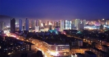
Air quality
According to a 2011 World Health Organization (based on Chinese statistics), Xining has the second worst air quality (annual mean PM10 ug/m3 of 141) among eleven western China cities, and is worse than Beijing (121).City Scape
Economy
The GDPGross domestic product
Gross domestic product refers to the market value of all final goods and services produced within a country in a given period. GDP per capita is often considered an indicator of a country's standard of living....
per capita was ¥19,494 (ca. US$2,800) in 2008, ranked no. 382 among 659 Chinese cities. Its main industries are wool spinning and textiles, fur, meat, milk, salt, and light processing industries.
Economic and Technological Development Zones
- Xining Economic & Technological Development Zone
Xining Economic & Technological Development Zone (ZETDZ) was approved as state-level development zone in July 2000. It has a planned area of 4.4 square kilometers. XETDZ lies in the east of Xining, the capital city of Qinghai province, 5 kilometers away from downtown. Located in the east of the province, Xining stands at the upper reaches of the Huangshui River-one of the Yellow River's branches. The city is surrounded by the mountains with an average elevation of 2261 meters and the highest at 4393 meters. Xining Economic and Technological Development Zone (XETDZ) is the first of its kind at the national level on the Qinghai-Tibet Plateau. It is established to fulfill the nation's strategy of developing the west.
XETDZ enjoys a convenient transportation system, connected by the Xining-Lanzhou expressway and run through by two main roads, the broadest roads of the city. It is 4 kilometers away from the railway station, 15 kilometers from Xi'ning Airport, a grade 4D airport with 14 airlines to other cities such as Beijing, Guangzhou, Shanghai, Chengdu and Xi'an. Xi'ning is Qinghai province's passage to the outside world, a transportation center with more than ten highways, over one hundred roads and two railways, Lanzhou-Qinghai and Qinghai-Tibet Railways in and out of the city.
It focuses on the development of following industries: chemicals based on salt lake resources, nonferrous metals, and petroleum and natural gas processing; special medicine, foods and bio-chemicals using local plateau animals and plants; new products involving ecological and environmental protection, high technology, new materials as well as information technology; and services such as logistics, banking, real estate, tourism, hotel, catering, agency and international trade.
Demographics
Sixth National Population Census of the People's Republic of China
The Sixth National Population Census of the People's Republic of China, also referred to as the 2010 Chinese Census, was conducted by the National Bureau of Statistics of the People's Republic of China with a zero hour of November 1, 2010....
, the prefecture-level city of Xining has a population of 2,208,708 inhabitants, 229,508 persons more than in 2000 (and the demographic growth for the period 2000-2010 was of 1.1% per year).
At present, four districts, three counties, and a national economic and technological development zone are under the administration of the local government. With a population of more than two million, Xining is the first city on the upper reaches of the Yellow River
Yellow River
The Yellow River or Huang He, formerly known as the Hwang Ho, is the second-longest river in China and the sixth-longest in the world at the estimated length of . Originating in the Bayan Har Mountains in Qinghai Province in western China, it flows through nine provinces of China and empties into...
to achieve a population in the millions. There are about 37 nationalities living here, though it is only the Han
Han Chinese
Han Chinese are an ethnic group native to China and are the largest single ethnic group in the world.Han Chinese constitute about 92% of the population of the People's Republic of China , 98% of the population of the Republic of China , 78% of the population of Singapore, and about 20% of the...
, Hui
Hui people
The Hui people are an ethnic group in China, defined as Chinese speaking people descended from foreign Muslims. They are typically distinguished by their practice of Islam, however some also practice other religions, and many are direct descendants of Silk Road travelers.In modern People's...
, Monguor (Tu people in Chinese - 土族) and Tibetan
Tibetan people
The Tibetan people are an ethnic group that is native to Tibet, which is mostly in the People's Republic of China. They number 5.4 million and are the 10th largest ethnic group in the country. Significant Tibetan minorities also live in India, Nepal, and Bhutan...
who are numerically significant. Local traditions and customs are influenced by the Tibetans, Monguor, Muslims, and Han. On 2010 Census numbers, Han Chinese represent 74.04% of the total population of Xining, while Hui (16.26%), Tibetan (5.51%) and Tu (2.6%) are the main minority groups in the city
Ethnic minorities in China
Ethnic minorities in China are the non-Han Chinese population in the People's Republic of China. The People's Republic of China officially recognizes 55 ethnic minority groups within China in addition to the Han majority. As of 2010, the combined population of officially recognised minority...
Administrative divisions
The municipality oversees seven districtsDistrict (China)
The term district, in the context of China, is used to refer to several unrelated political divisions in both ancient and modern China....
and counties
Counties of the People's Republic of China
County is the standard English translation of Xiàn or formally County level divisions. In the People's Republic of China , counties are found in the third level of the administrative hierarchy in Provinces and Autonomous regions, and the 2nd level in municipalities and Hainan province, a level that...
. The data here are presented in km² and in population according to 2010 Census:
| Map | # | English Name | Simplified | Traditional | Pinyin | Area | Population | Density |
|---|---|---|---|---|---|---|---|---|
| City proper | ||||||||
| 1 | Chengzhong District Chengzhong District, Xining Chengzhong is a district of the city-level prefecture of Xining , the capital of the Chinese province of Qinghai. It has an area of 10.5 km² and has 150,000 inhabitants .- External links :*... |
城中区 | 城中區 | Chéngzhōng Qū | 11 | 296,987 | 26,999 | |
| Suburban | ||||||||
| 2 | Chengdong District Chengdong District Chengdong District is a district of Qinghai Province, China. It is under the administration of Xining city.... |
城东区 | 城東區 | Chéngdōng Qū | 115 | 359,688 | 3,128 | |
| 3 | Chengxi District Chengxi District Chengxi District is a district in Xining municipality, Qinghai.It covers the western part of Xining's built-up conurbation. It has over 200 000 residents . Ethnically, most are Han-nation; there are also Hui , Tibetan , Tujia , etc... |
城西区 | 城西區 | Chéngxī Qū | 79 | 242,627 | 3,071 | |
| 4 | Chengbei District Chengbei District Chengbei District is a district of Qinghai Province, China. It is under the administration of Xining city.... |
城北区 | 城北區 | Chéngběi Qū | 138 | 299,002 | 2,167 | |
| Rural | ||||||||
| 5 | Huangyuan County Huangyuan County Huangyuan County is a county of Qinghai Province, China. It is under the administration of Xining city.... |
湟源县 | 湟源縣 | Huángyuán Xiàn | 1,609 | 136,632 | 85 | |
| 6 | Huangzhong County Huangzhong County Huangzhong County is a county of Qinghai Province, China. It is under the administration of Xining city.... |
湟中县 | 湟中縣 | Huángzhōng Xiàn | 2,430 | 437,835 | 180 | |
| 7 | Datong Hui and Tu Autonomous County | 大通回族土族自治县 | 大通回族土族自治縣 | Dàtōng Huízú Tǔzú Zìzhìxiàn | 3,090 | 435,937 | 139 | |
Colleges and universities
- Qinghai UniversityQinghai UniversityQinghai University is a university located in Xining city, the capital of Qinghai province, China. Established in 1958, the university awards bachelor's degrees in the areas of economics and management, agriculture and stockbreeding, science and technology, engineering, veterinary sciences, adult...
(青海大学) - Qinghai Normal UniversityQinghai Normal UniversityQinghai Normal University is a university in Xining, Qinghai, China. Founded in 1956, it lies on the Huangshui River and has 2 colleges, 14 departments, 3 branches and a research institute.-References:*...
(青海师范大学) - Qinghai University for NationalitiesQinghai University for NationalitiesQinghai University for Nationalities is a university in Xining, Qinghai, China. It was established in December 1949 and was Qinghai's earliest university of higher education.-External links:*...
(青海民族大学)
Transportation
Lanzhou
Lanzhou is the capital and largest city of Gansu Province in Northwest China. A prefecture-level city, it is a key regional transportation hub, allowing areas further west to maintain railroad connections to the eastern half of the country....
in Gansu
Gansu
' is a province located in the northwest of the People's Republic of China.It lies between the Tibetan and Huangtu plateaus, and borders Mongolia, Inner Mongolia, and Ningxia to the north, Xinjiang and Qinghai to the west, Sichuan to the south, and Shaanxi to the east...
province, on what was traditionally the main trade route from northern China
Northern and southern China
Northern China and southern China are two approximate regions within China. The exact boundary between these two regions has never been precisely defined...
into Tibet
Tibet
Tibet is a plateau region in Asia, north-east of the Himalayas. It is the traditional homeland of the Tibetan people as well as some other ethnic groups such as Monpas, Qiang, and Lhobas, and is now also inhabited by considerable numbers of Han and Hui people...
and the Qaidam Basin. These routes are now followed by modern highway
Highway
A highway is any public road. In American English, the term is common and almost always designates major roads. In British English, the term designates any road open to the public. Any interconnected set of highways can be variously referred to as a "highway system", a "highway network", or a...
s.
Railway
Since 1959 Xining has been connected by railRail transport
Rail transport is a means of conveyance of passengers and goods by way of wheeled vehicles running on rail tracks. In contrast to road transport, where vehicles merely run on a prepared surface, rail vehicles are also directionally guided by the tracks they run on...
to the main Chinese system at Lanzhou; this railway extends into the Qaidam area via Haiyan
Haiyan County, Qinghai
Haiyan County, Qinghai is a county of Qinghai Province, China. It is under the administration of Haibei Tibetan Autonomous Prefecture ....
near Qinghai Lake
Qinghai Lake
Qinghai Lake , is a saline lake situated in the province of Qinghai, and is the largest lake in China. The names Qinghai and Kokonor both mean "Blue/Teal Sea/Lake" in Chinese and Mongolian. It is located about west of the provincial capital of Xining at 3,205 m above sea level in a depression...
to Golmud
Golmud
Golmud , sometimes transliterated as Ge'ermu or Geermu, is a county-level city in Qinghai Province, Western China. Administrated by Haixi Mongol and Tibetan Autonomous Prefecture, it is the second largest city in Qinghai and the third largest in the Tibetan Plateau . The population is now about...
and extends, since 2006, to Lhasa
Lhasa
Lhasa is the administrative capital of the Tibet Autonomous Region in the People's Republic of China and the second most populous city on the Tibetan Plateau, after Xining. At an altitude of , Lhasa is one of the highest cities in the world...
in Tibet
Tibet
Tibet is a plateau region in Asia, north-east of the Himalayas. It is the traditional homeland of the Tibetan people as well as some other ethnic groups such as Monpas, Qiang, and Lhobas, and is now also inhabited by considerable numbers of Han and Hui people...
.
Air
Xining Caojiabu AirportXining Caojiabu Airport
Xining Caojiabao Airport is an airport serving Xining, capital of Qinghai Province, China. It is located in Huzhu County, about east of downtown Xining. The airport began operation in 1991, and in October 2011 a new 3,800 meter long runway was built to replace the old one.-Airlines and...
serves the area with regularly scheduled passenger flights to major Chinese cities including Beijing, Shanghai, Hong Kong, Chengdu, Kunming, Xi'an, and Wuhan.
Tourism
Located in the southwest part of Xining City, the Kumbum MonasteryKumbum Monastery
Kumbum Monastery is a Buddhist monastery in Qinghai province, China. Kumbum was founded in 1583 in a narrow valley close to the village of Lusar in the Tibetan cultural region of Amdo. Its superior monastery is Drepung, immediately to the west of Lhasa...
or Ta'er Monastery is one of six famous monasteries in the Gelug
Gelug
The Gelug or Gelug-pa , also known as the Yellow Hat sect, is a school of Buddhism founded by Je Tsongkhapa , a philosopher and Tibetan religious leader...
(also called Yellow Hat Sect) of Tibetan Buddhism. Having a history of over 600 years, the Dongguan Mosque, located in the Xining City Zone, is one of the most famous mosques in the northwest region of China. It has splendid and diversiform towers, walls and halls in the mosque. Another unique religious structure is the Beishan Si (North Mountain Temple), a Taoist facility.
Qinghai Lake
Qinghai Lake , is a saline lake situated in the province of Qinghai, and is the largest lake in China. The names Qinghai and Kokonor both mean "Blue/Teal Sea/Lake" in Chinese and Mongolian. It is located about west of the provincial capital of Xining at 3,205 m above sea level in a depression...
and Bird Island. This alluring body of water is home to hundreds of thousands of birds. About 35 kilometers west of Xining City in Datong County, you can experience the magical power of Laoye Mountain. Every year on the 6th day of the 6th lunar month, the traditional singing festival attracts hundreds of thousands of visitors.
Food
A unique feature of dishes in Xining is that they are given names after the surname of their initiator. Here are some of the most famous: Liangfen
Jidou liangfen
Jidou liangfen is a traditional dish in the Yunnan cuisine of China, made from chickpeas. It is gelatinous in texture and greenish-gray in color, and served in blocks, either cold, fried, or boiled. The dish is particularly popular among the Naxi people, in the region of Lijiang.-External links:*...
(bean jelly) is made from pea powder and cut into short strips. Liangfen is served with vinegar, chili and mashed garlic, mustard and salt to enhance the taste the dish. Niangpi is a popular snack made of flour and baking soda. It can be found anywhere in Xining for four-yuan. The most famous version of this snack is called Mazhong Niangpi and can be found in the Mojia Jie. Zasui Tang is a soup cooked with lamb and oxen entrails. Locals often eat this snack for breakfast. The hot soup helps warm people during the winter. Muslim Yoghurt is a must while in Xining – this breakfast is a kind of substance made by local Muslim families and is served in small bowls for one-yuan. Terrine is a popular snack in Xining. It is a small hot pot which contains beef, mutton, been curd and vermicelli. Mutton Eaten with Fingers is the most famous snack in Qinghai Province. It is made of fresh mutton and served with a little salt. This snack is the favorite food of the herdsmen of Qinghai Province.
In Xining, some restaurants serve varieties of 'plateau flavor', such as Feng'er Liji (a round lamb tenderloin), Danbai Chongcao Ji (a medicine cuisine made of chicken, Chinese caterpillar fungus and eggs), Jinyu Facai (pork wrapped in flagelliform nostoc
Nostoc
Nostoc is a genus of cyanobacteria found in a variety of environmental niches that forms colonies composed of filaments of moniliform cells in a gelatinous sheath.The name "Nostoc" was invented by Paracelsus...
and shaped as a goldfish) among others. These dishes are often cooked by the locals at home.
There are also many small restaurants offering noodles. Gan Ban is a very common noodle dish. Perhaps Mian Pian, which means "noodle leaves" is the most common noodle plate among the Qinghai people.
On the streets, many Muslims sell spicy lamb brochettes.
Due to the cold climate, residents of Xining are also fond of strong spirits - Xining has the reputation of being one of the heaviest regions of alcohol consumption in China.