
Willamette Valley AVA
Encyclopedia
The Willamette Valley AVA , is an American Viticultural Area
which lies in the Willamette Valley
of Oregon
. The AVA is the wine growing region which encompasses the drainage basin
of the Willamette River
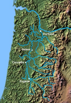
. It stretches from the Columbia River
in the north to just south of Eugene
in the south, where the Willamette Valley
ends; and from the Oregon Coast Range
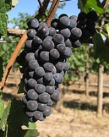
in the west to the Cascade Mountains in the east. At 5200 square miles (13,467.9 km²), it is the largest AVA in the state, and contains most of the state's wineries; approximately 200 as of 2006. The boundaries of the Willamette Valley AVA were established in 1984, and since then six new, smaller AVAs have been created within the northern portion of Willamette Valley AVA. The Willamette Valley has a cool, moist climate, and is recognized worldwide for its Pinot Noir
.
Although this distinction is not officially recognized, many wine connoisseurs further divide the Willamette Valley into northern and southern regions, the dividing line being the approximate latitude of Salem
(approximately 45° north latitude).
Not all portions of the Willamette Valley are suitable for vineyards, however, and the largest concentration of wineries is found west of the Willamette River
, on the leeward slopes of the Coast Range, or among the numerous river and stream valleys created by Willamette River tributaries. By far, the largest concentration of wineries is in Yamhill County.

 There are six American Viticultural Areas within the Willamette Valley AVA. These smaller AVAs recognize regions within the larger Willamette Valley AVA that have distinctive climate
, soil
, elevation
, or other physical features that make them noteworthy for wine production.
, established in 2006, stretches 20 miles (32 km) from Wilsonville
in the southeast to Forest Grove
in the northwest. The Chehalem Mountains includes Ribbon Ridge, Parrett Mountain, and Bald Peak
. The petition process for the creation of the AVA began in 2001 and was led by David Adelsheim of Adelsheim Vineyard.
in the hills north and west of Dundee
The area is 6,940 acres (28.1 km²) in total size, with 1,300 acres (530 ha) planted with grapes. Over 25 wineries and independent vineyards in this region produce over 44,000 cases of wine. The area is particularly noted for its Pinot Noir
; several wineries in the AVA have won international recognition for their wines.
stretches from the town of Amity
in the north to Salem
in the south. The hills cover an area west of the Willamette River
approximately 15 miles (24 km) long by 6 miles (10 km) wide. The Eola-Amity Hills area benefits from steady winds off the Pacific Ocean
that reach the Willamette Valley
through the Van Duzer corridor, a gap in the Oregon Coast Range
, moderating the summer temperatures. The name Eola is a tribute to the windy conditions in the area, and is derived from Aeolus
, the Greek god of wind.
near McMinnville
was established in 2005, in the hills to the southwest of McMinnville, roughly running from McMinnville to Sheridan
. The AVA includes 14 wineries and 523 acres (2.1 km²) of vineyards, and includes lands with elevations ranging from 200 to 1000 feet (304.8 m).
, between Newberg
and Gaston
, is a ridge containing uplift of ocean sediment. It lies at 45° 21' N, 123° 04' W, at the northwest end of the Chehalem Mountains. The name originates in the 19th century. The ridge is approximately 0.25 mile (0.402335 km) wide and 3.5 miles (5.63 km) long, and is 3350 acres (14 km²) in area, with 500 acres (2 km²) planted on 20 vineyards. It is estimated that between 1000 acres (4 km²) and 1400 acres (6 km²) in the region is suitable for planting.
in the area surrounding the towns of Yamhill
and Carlton
. Only grapes grown in vineyards with elevations ranging from 200 feet (61 m) to 1000 feet (304.8 m) may be use to produce wines that bear the appellation name on their labels. The AVA includes over 1200 acres (5 km²) of vineyard, and the region is in the rain shadow
of the 3500 feet (1,066.8 m) Oregon Coast Range, a short distance to the west. The AVA was established in 2005.
American Viticultural Area
An American Viticultural Area is a designated wine grape-growing region in the United States distinguishable by geographic features, with boundaries defined by the Alcohol and Tobacco Tax and Trade Bureau , United States Department of the Treasury....
which lies in the Willamette Valley
Willamette Valley
The Willamette Valley is the most populated region in the state of Oregon of the United States. Located in the state's northwest, the region is surrounded by tall mountain ranges to the east, west and south and the valley's floor is broad, flat and fertile because of Ice Age conditions...
of Oregon
Oregon
Oregon is a state in the Pacific Northwest region of the United States. It is located on the Pacific coast, with Washington to the north, California to the south, Nevada on the southeast and Idaho to the east. The Columbia and Snake rivers delineate much of Oregon's northern and eastern...
. The AVA is the wine growing region which encompasses the drainage basin
Drainage basin
A drainage basin is an extent or an area of land where surface water from rain and melting snow or ice converges to a single point, usually the exit of the basin, where the waters join another waterbody, such as a river, lake, reservoir, estuary, wetland, sea, or ocean...
of the Willamette River
Willamette River
The Willamette River is a major tributary of the Columbia River, accounting for 12 to 15 percent of the Columbia's flow. The Willamette's main stem is long, lying entirely in northwestern Oregon in the United States...
. It stretches from the Columbia River
Columbia River
The Columbia River is the largest river in the Pacific Northwest region of North America. The river rises in the Rocky Mountains of British Columbia, Canada, flows northwest and then south into the U.S. state of Washington, then turns west to form most of the border between Washington and the state...
in the north to just south of Eugene
Eugene, Oregon
Eugene is the second largest city in the U.S. state of Oregon and the seat of Lane County. It is located at the south end of the Willamette Valley, at the confluence of the McKenzie and Willamette rivers, about east of the Oregon Coast.As of the 2010 U.S...
in the south, where the Willamette Valley
Willamette Valley
The Willamette Valley is the most populated region in the state of Oregon of the United States. Located in the state's northwest, the region is surrounded by tall mountain ranges to the east, west and south and the valley's floor is broad, flat and fertile because of Ice Age conditions...
ends; and from the Oregon Coast Range
Oregon Coast Range
The Oregon Coast Range, often called simply the Coast Range and sometimes the Pacific Coast Range, is a mountain range, in the Pacific Coast Ranges physiographic region, in the U.S. state of Oregon along the Pacific Ocean...
in the west to the Cascade Mountains in the east. At 5200 square miles (13,467.9 km²), it is the largest AVA in the state, and contains most of the state's wineries; approximately 200 as of 2006. The boundaries of the Willamette Valley AVA were established in 1984, and since then six new, smaller AVAs have been created within the northern portion of Willamette Valley AVA. The Willamette Valley has a cool, moist climate, and is recognized worldwide for its Pinot Noir
Pinot Noir
Pinot noir is a black wine grape variety of the species Vitis vinifera. The name may also refer to wines created predominantly from Pinot noir grapes...
.
Although this distinction is not officially recognized, many wine connoisseurs further divide the Willamette Valley into northern and southern regions, the dividing line being the approximate latitude of Salem
Salem, Oregon
Salem is the capital of the U.S. state of Oregon, and the county seat of Marion County. It is located in the center of the Willamette Valley alongside the Willamette River, which runs north through the city. The river forms the boundary between Marion and Polk counties, and the city neighborhood...
(approximately 45° north latitude).
Climate
The climate of Willamette Valley is mild year-round. Winters are typically cool and wet, summers are dry and warm; heat above 90 °F (32 °C) only occurs 5 to 15 days per year, and the temperature drops below 0 °F (-18 °C) once every 25 years. Most rainfall occurs in the late autumn, winter, and early spring, when temperatures are the coldest. The valley gets relatively little snow (5 inches (13 cm) to 10 inches (25 cm)) per year.Not all portions of the Willamette Valley are suitable for vineyards, however, and the largest concentration of wineries is found west of the Willamette River
Willamette River
The Willamette River is a major tributary of the Columbia River, accounting for 12 to 15 percent of the Columbia's flow. The Willamette's main stem is long, lying entirely in northwestern Oregon in the United States...
, on the leeward slopes of the Coast Range, or among the numerous river and stream valleys created by Willamette River tributaries. By far, the largest concentration of wineries is in Yamhill County.
Sub-appellations
Climate
Climate encompasses the statistics of temperature, humidity, atmospheric pressure, wind, rainfall, atmospheric particle count and other meteorological elemental measurements in a given region over long periods...
, soil
Soil
Soil is a natural body consisting of layers of mineral constituents of variable thicknesses, which differ from the parent materials in their morphological, physical, chemical, and mineralogical characteristics...
, elevation
Elevation
The elevation of a geographic location is its height above a fixed reference point, most commonly a reference geoid, a mathematical model of the Earth's sea level as an equipotential gravitational surface ....
, or other physical features that make them noteworthy for wine production.
Chehalem Mountains AVA
The Chehalem Mountains AVAChehalem Mountains AVA
The Chehalem Mountains AVA is an American Viticultural Area located in the Clackamas, Yamhill, and Washington counties of northwestern Oregon. It is entirely contained within the Willamette Valley AVA. The region stretches from Wilsonville in the southeast to Forest Grove in the northwest. The...
, established in 2006, stretches 20 miles (32 km) from Wilsonville
Wilsonville, Oregon
Wilsonville is a city primarily in Clackamas County, Oregon, United States. A portion of the northern section of the city is in Washington County. Originally founded as Boones Landing due to the Boones Ferry which crossed the Willamette River at the location, the community became Wilsonville in...
in the southeast to Forest Grove
Forest Grove, Oregon
Forest Grove is a city in Washington County, Oregon, United States, west of Portland. Originally a small farm town, it is now primarily a bedroom suburb of Portland. Settled in the 1840s, the town was platted in 1850 and then incorporated in 1872 and was the first city in Washington County...
in the northwest. The Chehalem Mountains includes Ribbon Ridge, Parrett Mountain, and Bald Peak
Bald Peak
Bald Peak is a mountain top and highest point in the Chehalem Mountains in the Northwest area of the U.S. state of Oregon. Located in Yamhill County near the county line with Washington County, the tall point is the highest point within the Willamette Valley...
. The petition process for the creation of the AVA began in 2001 and was led by David Adelsheim of Adelsheim Vineyard.
Dundee Hills AVA
The Dundee Hills AVADundee Hills AVA
The Dundee Hills AVA is an American Viticultural Area located in Yamhill County, Oregon. It is entirely contained within the Willamette Valley AVA, and is approximately southwest of Portland, near the town of Dundee. The area is in total size, with planted with grapes. The Dundee Hills are a...
in the hills north and west of Dundee
Dundee, Oregon
Dundee is a city in Yamhill County, Oregon, United States. The population was 2,598 at the 2000 census. The 2007 estimate is 3,040 residents.-History:...
The area is 6,940 acres (28.1 km²) in total size, with 1,300 acres (530 ha) planted with grapes. Over 25 wineries and independent vineyards in this region produce over 44,000 cases of wine. The area is particularly noted for its Pinot Noir
Pinot Noir
Pinot noir is a black wine grape variety of the species Vitis vinifera. The name may also refer to wines created predominantly from Pinot noir grapes...
; several wineries in the AVA have won international recognition for their wines.
Eola-Amity Hills AVA
The Eola-Amity Hills AVAEola-Amity Hills AVA
The Eola-Amity Hills AVA is an American Viticultural Area located in Polk County and Yamhill County, Oregon. It is entirely contained within the Willamette Valley AVA, and stretches from the city of Amity in the north to Salem in the south. The Eola and Amity hills cover an area west of the...
stretches from the town of Amity
Amity, Oregon
Amity is a city in Yamhill County, Oregon, United States. As of the 2010 Census, the population was 1,614.-History:The town was established between 1848 and 1849 by Joseph and Ahio S. Watt, two brothers who had immigrated to Oregon over the Oregon Trail. Part of Joseph’s land claim became the...
in the north to Salem
Salem, Oregon
Salem is the capital of the U.S. state of Oregon, and the county seat of Marion County. It is located in the center of the Willamette Valley alongside the Willamette River, which runs north through the city. The river forms the boundary between Marion and Polk counties, and the city neighborhood...
in the south. The hills cover an area west of the Willamette River
Willamette River
The Willamette River is a major tributary of the Columbia River, accounting for 12 to 15 percent of the Columbia's flow. The Willamette's main stem is long, lying entirely in northwestern Oregon in the United States...
approximately 15 miles (24 km) long by 6 miles (10 km) wide. The Eola-Amity Hills area benefits from steady winds off the Pacific Ocean
Pacific Ocean
The Pacific Ocean is the largest of the Earth's oceanic divisions. It extends from the Arctic in the north to the Southern Ocean in the south, bounded by Asia and Australia in the west, and the Americas in the east.At 165.2 million square kilometres in area, this largest division of the World...
that reach the Willamette Valley
Willamette Valley
The Willamette Valley is the most populated region in the state of Oregon of the United States. Located in the state's northwest, the region is surrounded by tall mountain ranges to the east, west and south and the valley's floor is broad, flat and fertile because of Ice Age conditions...
through the Van Duzer corridor, a gap in the Oregon Coast Range
Oregon Coast Range
The Oregon Coast Range, often called simply the Coast Range and sometimes the Pacific Coast Range, is a mountain range, in the Pacific Coast Ranges physiographic region, in the U.S. state of Oregon along the Pacific Ocean...
, moderating the summer temperatures. The name Eola is a tribute to the windy conditions in the area, and is derived from Aeolus
Aeolus
Aeolus was the ruler of the winds in Greek mythology. In fact this name was shared by three mythic characters. These three personages are often difficult to tell apart, and even the ancient mythographers appear to have been perplexed about which Aeolus was which...
, the Greek god of wind.
McMinnville AVA
The McMinnville AVAMcMinnville AVA
The McMinnville AVA is an American Viticultural Area located in Yamhill County, Oregon. It is entirely contained within the Willamette Valley AVA, roughly running from McMinnville to Sheridan. The AVA was created as a result of a successful petition from Kevin Byrd of Youngberg Hill Vineyards...
near McMinnville
McMinnville, Oregon
McMinnville is the county seat and largest city of Yamhill County, Oregon, United States. According to Oregon Geographic Names, it was named by its founder, William T. Newby , an early immigrant on the Oregon Trail, for his hometown of McMinnville, Tennessee...
was established in 2005, in the hills to the southwest of McMinnville, roughly running from McMinnville to Sheridan
Sheridan, Oregon
Sheridan is a city in Yamhill County, Oregon, United States. Platted in the 1860s when it received a post office, the city was incorporated in 1880. A major fire burned much of the city in 1913, and a flood covered much of the city in 1964...
. The AVA includes 14 wineries and 523 acres (2.1 km²) of vineyards, and includes lands with elevations ranging from 200 to 1000 feet (304.8 m).
Ribbon Ridge AVA
The Ribbon Ridge AVARibbon Ridge AVA
The Ribbon Ridge AVA is an American Viticultural Area in Yamhill County, Oregon. It is the smallest AVA in Oregon and is entirely contained within the Chehalem Mountains AVA, which in turn is entirely contained within the larger Willamette Valley AVA. Ribbon Ridge stretches between the towns of...
, between Newberg
Newberg, Oregon
-Demographics:As of the census of 2000, there were 18,064 people, 6,099 households, and 4,348 families residing in the city. The population density was 3,599.4 people per square mile . There were 6,435 housing units at an average density of 1,282.2 per square mile...
and Gaston
Gaston, Oregon
Gaston is a city in Washington County, Oregon, United States. The population was 600 at the 2000 census. The 2006 estimate is 630 residents.-Early history:...
, is a ridge containing uplift of ocean sediment. It lies at 45° 21' N, 123° 04' W, at the northwest end of the Chehalem Mountains. The name originates in the 19th century. The ridge is approximately 0.25 mile (0.402335 km) wide and 3.5 miles (5.63 km) long, and is 3350 acres (14 km²) in area, with 500 acres (2 km²) planted on 20 vineyards. It is estimated that between 1000 acres (4 km²) and 1400 acres (6 km²) in the region is suitable for planting.
Yamhill-Carlton District AVA
The Yamhill-Carlton District AVAYamhill-Carlton District AVA
The Yamhill-Carlton District AVA is an American Viticultural Area located in both Washington County and Yamhill County, Oregon. It is entirely contained within the Willamette Valley AVA, and surrounds the towns of Carlton and Yamhill. The mountain ridges surrounding the district form a horseshoe...
in the area surrounding the towns of Yamhill
Yamhill, Oregon
Yamhill is a city in Yamhill County, Oregon, United States. Located in the northern part of the county, it is situated at the intersection of Oregon Route 47 and Oregon Route 240. The population was 794 at the 2000 census. The 2008 estimate is 855 residents...
and Carlton
Carlton, Oregon
Carlton is a city in Yamhill County, Oregon, United States. According to the 2000 United States Census, the municipality population was 1,514. The 2007 estimate is 1,755 residents.-History:...
. Only grapes grown in vineyards with elevations ranging from 200 feet (61 m) to 1000 feet (304.8 m) may be use to produce wines that bear the appellation name on their labels. The AVA includes over 1200 acres (5 km²) of vineyard, and the region is in the rain shadow
Rain shadow
A rain shadow is a dry area on the lee side of a mountainous area. The mountains block the passage of rain-producing weather systems, casting a "shadow" of dryness behind them. As shown by the diagram to the right, the warm moist air is "pulled" by the prevailing winds over a mountain...
of the 3500 feet (1,066.8 m) Oregon Coast Range, a short distance to the west. The AVA was established in 2005.