

Willamette Stone
Encyclopedia
Obelisk
An obelisk is a tall, four-sided, narrow tapering monument which ends in a pyramid-like shape at the top, and is said to resemble a petrified ray of the sun-disk. A pair of obelisks usually stood in front of a pylon...
originally located in the western hills of Portland, Oregon
Portland, Oregon
Portland is a city located in the Pacific Northwest, near the confluence of the Willamette and Columbia rivers in the U.S. state of Oregon. As of the 2010 Census, it had a population of 583,776, making it the 29th most populous city in the United States...
in the United States
United States
The United States of America is a federal constitutional republic comprising fifty states and a federal district...
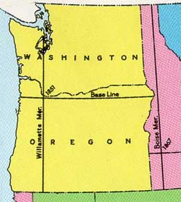
. It marked the intersection and origin of the Willamette Meridian and Willamette Baseline, which defined the grid system of sections and townships
Survey township
Survey township, sometimes called Congressional township, as used by the United States Public Land Survey System, refers to a square unit of land, that is nominally six miles on a side...
from which all real property
Real property
In English Common Law, real property, real estate, realty, or immovable property is any subset of land that has been legally defined and the improvements to it made by human efforts: any buildings, machinery, wells, dams, ponds, mines, canals, roads, various property rights, and so forth...
in the states of Oregon
Oregon
Oregon is a state in the Pacific Northwest region of the United States. It is located on the Pacific coast, with Washington to the north, California to the south, Nevada on the southeast and Idaho to the east. The Columbia and Snake rivers delineate much of Oregon's northern and eastern...
and Washington has been measured following the Donation Land Claim Act of 1850. The Willamette Meridian runs north-south from the marker, and the Willamette Base Line runs east to west through the marker.
History
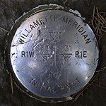
The location of the original stone is now indicated by a stainless steelStainless steel
In metallurgy, stainless steel, also known as inox steel or inox from French "inoxydable", is defined as a steel alloy with a minimum of 10.5 or 11% chromium content by mass....
marker in Willamette Stone State Heritage Site, an Oregon state park
State park
State parks are parks or other protected areas managed at the federated state level within those nations which use "state" as a political subdivision. State parks are typically established by a state to preserve a location on account of its natural beauty, historic interest, or recreational...
approximately four miles (6.4 km) west of downtown Portland. The site is on Skyline Boulevard, in the West Hills overlooking the Tualatin Valley
Tualatin Valley
The Tualatin Valley is a farming and suburban region southwest of Portland, Oregon in the United States. The valley is formed by the meandering Tualatin River, a tributary of the Willamette River at the northwest corner of the Willamette Valley, east of the Northern Oregon Coast Range...
and the Willamette River
Willamette River
The Willamette River is a major tributary of the Columbia River, accounting for 12 to 15 percent of the Columbia's flow. The Willamette's main stem is long, lying entirely in northwestern Oregon in the United States...
watershed.
The grid defined by the stone extended the Public Land Survey System
Public Land Survey System
The Public Land Survey System is a method used in the United States to survey and identify land parcels, particularly for titles and deeds of rural, wild or undeveloped land. Its basic units of area are the township and section. It is sometimes referred to as the rectangular survey system,...
and was used as the basis of land claims in the Oregon Territory
Oregon Territory
The Territory of Oregon was an organized incorporated territory of the United States that existed from August 14, 1848, until February 14, 1859, when the southwestern portion of the territory was admitted to the Union as the State of Oregon. Originally claimed by several countries , the region was...
. The first marker, a red cedar stake, was placed on the site on June 4, 1851, by John B. Preston
John B. Preston
John B. Preston was the first Surveyor General of the Oregon Territory in the Western United States. He was appointed by President Millard Fillmore to create a system for surveying land in the territory; he lost his position in 1853, and "drifted into obscurity."- External links :...
, the first Surveyor General of the Oregon Territory. Preston was appointed by President Millard Fillmore
Millard Fillmore
Millard Fillmore was the 13th President of the United States and the last member of the Whig Party to hold the office of president...
to create a system for surveying land in the territory; he lost his position in 1853, and "drifted into obscurity." The location was chosen such that the base line would not cross the Columbia River
Columbia River
The Columbia River is the largest river in the Pacific Northwest region of North America. The river rises in the Rocky Mountains of British Columbia, Canada, flows northwest and then south into the U.S. state of Washington, then turns west to form most of the border between Washington and the state...
and the meridian
Principal meridian
A meridian is an imaginary line on the Earth's surface from the North Pole to the South Pole that connects all locations with a given longitude. Each is half of a great circle on the Earth's surface...
would lie west of Vancouver Lake
Vancouver Lake
Vancouver Lake is a large lake just west of Vancouver, Washington, United States, north of the Columbia River and Portland, Oregon), south of Ridgefield, Washington and the Ridgefield National Wildlife Refuge....
. The grid system was an extension of the system used in the Northwest Territory
Northwest Territory
The Territory Northwest of the River Ohio, more commonly known as the Northwest Territory, was an organized incorporated territory of the United States that existed from July 13, 1787, until March 1, 1803, when the southeastern portion of the territory was admitted to the Union as the state of Ohio...
proposed by Thomas Jefferson
Thomas Jefferson
Thomas Jefferson was the principal author of the United States Declaration of Independence and the Statute of Virginia for Religious Freedom , the third President of the United States and founder of the University of Virginia...
. The Willamette Stone marked the location of the first townships and ranges north and south of the marker.
The stake was replaced by a stone obelisk
Obelisk
An obelisk is a tall, four-sided, narrow tapering monument which ends in a pyramid-like shape at the top, and is said to resemble a petrified ray of the sun-disk. A pair of obelisks usually stood in front of a pylon...
on July 25, 1885. On two sides, the stone was marked with the words "BASE" and "LINE", while on the other two sides it was marked with the words "WILL." and "MER." The stone was vandalized in the 1980s and replaced with the current marker, as well as an accompanying bronze
Bronze
Bronze is a metal alloy consisting primarily of copper, usually with tin as the main additive. It is hard and brittle, and it was particularly significant in antiquity, so much so that the Bronze Age was named after the metal...
plaque: "Beginning here, the Willamette Meridian was established running north to Puget Sound and south to the California border, and the baseline was established running east to the Idaho border and west to the Pacific Ocean."
Streets
The location of the Willamette Meridian and Willamette Baseline can be identified by various streets that follow their courses, often named to call attention to this fact.North-South streets & the meridian
- In Multnomah CountyMultnomah County, OregonMultnomah County is one of 36 counties in the U.S. state of Oregon. Though smallest in area, it is the most populous as its county seat, Portland, is the state's largest city...
, Southwest 65th Avenue overlays the Willamette Meridian. A short section of Interstate 5Interstate 5Interstate 5 is the main Interstate Highway on the West Coast of the United States, running largely parallel to the Pacific Ocean coastline from Canada to Mexico . It serves some of the largest cities on the U.S...
immediately south of the Barbur Blvd. interchange also overlays the meridian. - In Clackamas CountyClackamas County, OregonClackamas County is a county located in the U.S. state of Oregon. The county was named after the Native Americans living in the area, the Clackamas Indians, who were part of the Chinookan people. As of 2010, the population was 375,992...
, Southwest Stafford Road and Meridian Road overlay the meridian. - In Marion CountyMarion County, OregonMarion County is a county located in the U.S. state of Oregon. It was originally named the Champooick District, after Champoeg, a meeting place on the Willamette River. On September 3, 1849, the territorial legislature renamed it in honor of Francis Marion, a Continental Army general of the...
there are several sections of a road named Meridian Road that parallel the meridian. Due to the hilly landscape, not all sections of this road overlay the meridian. - In Jackson CountyJackson County, Oregon-National protected areas:* Cascade–Siskiyou National Monument* Crater Lake National Park * Klamath National Forest * Rogue River-Siskiyou National Forest * Umpqua National Forest -Demographics:...
, Meridian Road runs along several miles of the meridian. - There is a Meridian Street in NewbergNewberg, Oregon-Demographics:As of the census of 2000, there were 18,064 people, 6,099 households, and 4,348 families residing in the city. The population density was 3,599.4 people per square mile . There were 6,435 housing units at an average density of 1,282.2 per square mile...
. However, it is several miles west of the actual meridian. - In Kitsap County, WashingtonKitsap County, WashingtonKitsap County is a county located in the U.S. state of Washington, named after Chief Kitsap of the Suquamish tribe. As of 2011 state estimate, its population was 253,900. Its county seat is at Port Orchard, and its largest city is Bremerton....
, west of SilverdaleSilverdale, WashingtonSilverdale is a census-designated place in Kitsap County, Washington, in the United States. The population was 19,204 at the 2010 census.Despite many attempts at incorporation, Silverdale remains an unincorporated community....
there is Willamette Meridian Road NW which runs along the meridian for about three miles (5 km). - In Thurston County, Washington, east of LaceyLacey, WashingtonLacey is a city in Thurston County, Washington, United States. Established as a suburb of Olympia, its population was 42,393 at the 2010 census out of a county population of 252,264.-History:...
, there are two stretches of road along the meridian about two miles (3 km) long called Meridian Road.
East-West streets & the baseline
- Stark Street in PortlandPortland, OregonPortland is a city located in the Pacific Northwest, near the confluence of the Willamette and Columbia rivers in the U.S. state of Oregon. As of the 2010 Census, it had a population of 583,776, making it the 29th most populous city in the United States...
runs along the Willamette Baseline. - Baseline Road in TillamookTillamook County, OregonTillamook County is a county located in the U.S. state of Oregon. The county is named for the Tillamook, a Native American tribe who were living in the area in the early 19th century at the time of European American settlement. In 2010, the county's population was 25,250...
, WashingtonWashington County, Oregon- Major highways :* Interstate 5* Interstate 205* U.S. Route 26* Oregon Route 6* Oregon Route 8* Oregon Route 10* Oregon Route 47* Oregon Route 99W* Oregon Route 210* Oregon Route 217* Oregon Route 219-Demographics:...
, Hood RiverHood River County, Oregon-Demographics:As of the census of 2000, there were 20,411 people, 7,248 households, and 5,175 families residing in the county. The population density was 39 people per square mile . There were 7,818 housing units at an average density of 15 per square mile...
, GilliamGilliam County, Oregon-Demographics:As of the census of 2000, there were 1,915 people, 819 households, and 543 families residing in the county. The population density was 2 people per square mile . There were 1,043 housing units at an average density of 1 per square mile...
, and MorrowMorrow County, OregonMorrow County is a county located in the U.S. state of Oregon, on the south side of the Columbia River. It is included in the 8 county definition of Eastern Oregon. The county is named for one of its first white settlers, Jackson L. Morrow, who was a member of the state legislature when the county...
counties all run along or start at the Willamette Baseline. - Division Street in Portland and Section Line Road in East Multnomah County follow the division between the first and second rows of square-mile sections south of the Willamette Baseline.
External links
- Surveying the Land, from the website of the End of the Oregon Trail Interpretive Center
- Location of the Willamette Meridian and the Oregon Base Line
- Willamette Stone State Heritage Site
- Photographs of the stone, published 1959