
.gif)
White River (Washington)
Encyclopedia
The White River is a white, glacial river
in the U.S. state
of Washington. It flows about 75 miles (121 km) from its source, the Emmons Glacier
on Mount Rainier
, to join the Puyallup River
at Sumner
. It defines part of the boundary between King
and Pierce
counties.
A second White River has its source in Glacier Peak Wilderness
and flows southeast to Lake Wenatchee.
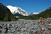 The source of the White River is the Emmons Glacier on the northeast side of Mount Rainier. The river flows from ice caves at the toe of the glacier. Its upper reach is contained within Mount Rainier National Park
. Shortly after emerging from the Emmons Glacier, the White River flows generally east, by the White River Campground, then the White River Ranger Station, after which it turns north. The river is paralled by much of its upper course by State Route 410
, called the Mather Memorial Parkway in the national park. After several miles the river exits Mount Rainier National Park and enters Mount Baker-Snoqualmie National Forest
.
The river turns gradually westward, passing several national forest campgrounds. Huckleberry Creek joins just below The Dalles Campground. Several miles downriver from there the White River is joined by one of its main tributaries, the West Fork White River, which also originates at a glacier in Mount Rainier National Park, in this case, Winthrop Glacier
. A few miles downriver from the West Fork confluence another major tributary joins, the Greenwater River
. The small settlement of Greenwater
is located at the confluence.
Below Greenwater, the White River flows generally west. It passes Federation Forest State Park
and is then joined by another tributary, the Clearwater River. Several miles downriver from there the White River is impounded by Mud Mountain Dam, which creates a marshy intermittent lake called Mud Mountain Lake. The dam was built for flood control purposes. Mud Mountain Lake only fills with water during conditions of exceptionally high streamflow.
Below Mud Mountain Dam the White River enters the greater Tacoma
metropolitan area. It flows between the cities of Buckley
and Enumclaw
, after which it makes a large bend northwest and then southwest, essentially flowing around Lake Tapps
. North of the lake, the White River flows through the Muckleshoot Indian Reservation
. Below that, to the west of Lake Tapps, the White River enters a broad floodplain
and flows past the city of Pacific
before emptying into the Puyallup River at Sumner.
Lake Tapps is a reservoir created in 1911 for hydroelectric purposes. A diversion dam near Buckley taps the White River's water, sending a portion of it through a flume, a canal, and a pipeline to Lake Tapps. An outlet canal on the west side of the lake routes water through the turbines of the Dieringer Powerhouse, after which the water is returned to the lower White River (or Stuck River as it is locally called in this area) via the Dieringer "tailrace".
near Auburn, and the combined river (under the name "White") joined the Black River
at Tukwila
, forming the Duwamish River
, which emptied into Elliott Bay
at Seattle. In 1906, a great flood coupled with a large log and debris jam diverted the White River southward into the Stuck River
thence into the Puyallup River, which empties into Commencement Bay
at Tacoma. The debris dam was replaced with a permanent diversion wall. Thus the White River remains a tributary of the Puyallup River today.
In the late 19th century farmers along the White River were subjected to nearly annual floods. Sometimes farmers would use dynamite to divert the river into different channels. In 1899 one such explosion went awry and ended up diverting most of the White River into the Stuck River, thence the Puyallup. Dynamiting the river channels continued until the major flood of 1906 which ended up sending the entire White River down the Stuck River. Due to the risk of floods, the diversion was not wanted by Pierce County, which sued King County in an attempt to have the White River rediverted away from the Stuck River. The lawsuit dragged on for years until 1913 when the two counties reached an agreement. Pierce County would keep the White River, but King County would pay 60% of the cost of flood control. Dams, levees, and barriers were built along the White River in hopes of preventing major flooding, but in 1933 a large flood inundated the region. The two counties realized they were unable to tame the river and so turned to the federal government. The result was Mud Mountain Dam.
Mud Mountain Dam, built by the United States Army Corps of Engineers
for flood control purposes, was completed in 1948. The dam blocks anadromous
fish passage, so a "trap and haul" system is used, in which fish are transported around the dam by truck. After Mud Mountain Dam was built, the farmers of the lower White River were freed from the previously near-constant worry about flooding.
In 1911 a diversion dam was built near Buckley which, along with a system of dikes around the originally small Lake Tapps, created a larger reservoir. Over the years a small community has developed around the lake. The reservoir's water is returned to the White River about 20 miles downstream from the diversion dam. Ownership and operation was transferred to Puget Sound Energy
. Recently, Puget Sound Energy sold the Lake to Cascade Water Alliance (CWA). CWA is currently undergoing environmental studies intending to use the lake as a drinking water source. The Lake has also been the focus of water quality issues through a planning process identified in the Pierce County
"White River Basin Plan", currently under final review.
Several miles upriver from the Lake Tapps diversion dam the White River is impounded by Mud Mountain Dam, for flood control purposes.
, Pink
, Chum
, and Coho salmon
, as well as Bull
, Rainbow
, Steelhead
, and Cutthroat trout
. Pink and Chum salmon dominate the runs. Interestingly, though no large natural lakes occur in the basin, Sockeye salmon are also present in very small numbers. The White River Coho salmon are a mixed population of hatchery and wild fish. The native Puget Sound
White River spring Chinook salmon (and Puyallup River fall Chinook that inhabit the River), Puget Sound winter Steelhead
, and Puget Sound/Coastal Bull trout
are listed as Threatened under the Endangered Species Act
.
and the militias of Washington Territory
as well as the U.S. Army
during the Puget Sound War
of 1855-1856.
River
A river is a natural watercourse, usually freshwater, flowing towards an ocean, a lake, a sea, or another river. In a few cases, a river simply flows into the ground or dries up completely before reaching another body of water. Small rivers may also be called by several other names, including...
in the U.S. state
U.S. state
A U.S. state is any one of the 50 federated states of the United States of America that share sovereignty with the federal government. Because of this shared sovereignty, an American is a citizen both of the federal entity and of his or her state of domicile. Four states use the official title of...
of Washington. It flows about 75 miles (121 km) from its source, the Emmons Glacier
Emmons Glacier
Emmons Glacier is a glacier on the northeast flank of Mount Rainier, in Washington. At , it has the largest surface area of any glacier in the contiguous United States. The glacier was named after the geologist Samuel Franklin Emmons after his involvement in a survey of Mount Rainier in...
on Mount Rainier
Mount Rainier
Mount Rainier is a massive stratovolcano located southeast of Seattle in the state of Washington, United States. It is the most topographically prominent mountain in the contiguous United States and the Cascade Volcanic Arc, with a summit elevation of . Mt. Rainier is considered one of the most...
, to join the Puyallup River
Puyallup River
The Puyallup River is a river in the U.S. state of Washington. About long, it is formed by glaciers on the west side of Mount Rainier. It flows generally northwest, emptying into Commencement Bay, part of Puget Sound...
at Sumner
Sumner, Washington
Sumner is a city in northern Pierce County, Washington, United States. The population was 9,451 at the 2010 census. Nearby cities include Puyallup to the west, Auburn to the north, and Enumclaw to the east.-History:...
. It defines part of the boundary between King
King County, Washington
King County is a county located in the U.S. state of Washington. The population in the 2010 census was 1,931,249. King is the most populous county in Washington, and the 14th most populous in the United States....
and Pierce
Pierce County, Washington
right|thumb|[[Tacoma, Washington|Tacoma]] - Seat of Pierce CountyPierce County is the second most populous county in the U.S. state of Washington. Formed out of Thurston County on December 22, 1852, by the legislature of Oregon Territory...
counties.
A second White River has its source in Glacier Peak Wilderness
Glacier Peak Wilderness
The Glacier Peak Wilderness, created by the US Forest Service in 1960 by efforts of the , four years before the 1964 wilderness legislation of the Congress, is located within portions of Chelan County, Snohomish County, and Skagit Counties in the North Cascades of Washington...
and flows southeast to Lake Wenatchee.
Course
Mount Rainier National Park
Mount Rainier National Park is a United States National Park located in southeast Pierce County and northeast Lewis County in Washington state. It was one of the US's earliest National Parks, having been established on March 2, 1899 as the fifth national park in the United States. The park contains...
. Shortly after emerging from the Emmons Glacier, the White River flows generally east, by the White River Campground, then the White River Ranger Station, after which it turns north. The river is paralled by much of its upper course by State Route 410
Washington State Route 410
State Route 410 is a long state highway that traverses Pierce, King, and Yakima counties in the U.S. state of Washington. It begins at an interchange with SR 167 in Sumner and travels southeast across the Cascade Range to a junction with U.S. Route 12 in Naches...
, called the Mather Memorial Parkway in the national park. After several miles the river exits Mount Rainier National Park and enters Mount Baker-Snoqualmie National Forest
Mount Baker-Snoqualmie National Forest
The Mount Baker-Snoqualmie National Forest in Washington extends more than along the western slopes of the Cascade Range from the Canadian border to the northern boundary of Mount Rainier National Park. Forest headquarters are located in the city of Everett....
.
The river turns gradually westward, passing several national forest campgrounds. Huckleberry Creek joins just below The Dalles Campground. Several miles downriver from there the White River is joined by one of its main tributaries, the West Fork White River, which also originates at a glacier in Mount Rainier National Park, in this case, Winthrop Glacier
Winthrop Glacier
The Winthrop Glacier is a large glacier on the northeastern side of Mount Rainier in Washington. Named after Theodore Winthrop, the body of ice covers 3.5 mile2 and has a volume of 18.5 billion feet3 . Starting at over at the Columbia Crest, the glacier heads north and descends steeply over the...
. A few miles downriver from the West Fork confluence another major tributary joins, the Greenwater River
Greenwater River
The Greenwater River is a river in the U.S. state of Washington. Its watershed drains a portion of the Cascade Range east and northeast of Mount Rainier, including parts of the Norse Peak Wilderness. It flows into the White River at Greenwater, which eventually flows into Puget Sound via the...
. The small settlement of Greenwater
Greenwater, Washington
Greenwater is a census-designated place in Pierce County, Washington, United States. The population was 67 at the 2010 census.Based on per capita income, Greenwater ranks 17th of 522 areas in the state of Washington to be ranked...
is located at the confluence.
Below Greenwater, the White River flows generally west. It passes Federation Forest State Park
Federation Forest State Park
Federation Forest State Park in King County, Washington is one of the Washington State Parks. It is a day-use park of of old-growth evergreen trees along the White River. Available activities include of hiking trail, an interpretive center with gift shop, birdwatching, wildlife viewing, and...
and is then joined by another tributary, the Clearwater River. Several miles downriver from there the White River is impounded by Mud Mountain Dam, which creates a marshy intermittent lake called Mud Mountain Lake. The dam was built for flood control purposes. Mud Mountain Lake only fills with water during conditions of exceptionally high streamflow.
Below Mud Mountain Dam the White River enters the greater Tacoma
Tacoma, Washington
Tacoma is a mid-sized urban port city and the county seat of Pierce County, Washington, United States. The city is on Washington's Puget Sound, southwest of Seattle, northeast of the state capital, Olympia, and northwest of Mount Rainier National Park. The population was 198,397, according to...
metropolitan area. It flows between the cities of Buckley
Buckley, Washington
Buckley is a city in Pierce County, Washington, United States. The population was 4,354 at the 2010 census.-Geography:Buckley is located at near the communities of Enumclaw, Bonney Lake, and Wilkeson....
and Enumclaw
Enumclaw, Washington
Enumclaw is a city in King County, Washington, United States. The population was 10,669 at the 2010 census.The Enumclaw Plateau, on which the city resides, was formed by a volcanic mudflow from Mount Rainier approximately 5,700 years ago....
, after which it makes a large bend northwest and then southwest, essentially flowing around Lake Tapps
Lake Tapps (Washington)
Lake Tapps is a reservoir in Pierce County, Washington. It was created in 1911 by Puget Sound Energy and operated for hydroelectric power until it ceased power production in 2004...
. North of the lake, the White River flows through the Muckleshoot Indian Reservation
Muckleshoot
The Muckleshoot are a Lushootseed Native American tribe, part of the Coast Salish peoples of the Pacific Northwest whose traditional territory and reservations is located in the area of Auburn, Washington, between Seattle and Tacoma...
. Below that, to the west of Lake Tapps, the White River enters a broad floodplain
Floodplain
A floodplain, or flood plain, is a flat or nearly flat land adjacent a stream or river that stretches from the banks of its channel to the base of the enclosing valley walls and experiences flooding during periods of high discharge...
and flows past the city of Pacific
Pacific, Washington
Pacific is a city in King and Pierce counties in the U.S. state of Washington. Located primarily in King County, the population was 6,606 at the 2010 census. Like its northern neighbor Algona, Pacific is sometimes mistaken for a part of Auburn.- History :...
before emptying into the Puyallup River at Sumner.
Lake Tapps is a reservoir created in 1911 for hydroelectric purposes. A diversion dam near Buckley taps the White River's water, sending a portion of it through a flume, a canal, and a pipeline to Lake Tapps. An outlet canal on the west side of the lake routes water through the turbines of the Dieringer Powerhouse, after which the water is returned to the lower White River (or Stuck River as it is locally called in this area) via the Dieringer "tailrace".
River modifications
Before 1906, the White River joined the Green RiverGreen River (Washington)
The Green River is a long river in the state of Washington in the United States, arising on the western slopes of the Cascade Mountains south of I-90....
near Auburn, and the combined river (under the name "White") joined the Black River
Black River (Duwamish River)
The Black River, also known as the Duwamish River, was a river in King County in the U.S. state of Washington. It drained Lake Washington until 1916 when the opening of the Lake Washington Ship Canal lowered the lake, causing the Black River to dry up...
at Tukwila
Tukwila, Washington
Tukwila is a city in King County, Washington, United States. The northern edge of Tukwila borders the city of Seattle. The population was 19,107 at the 2010 census.-History:...
, forming the Duwamish River
Duwamish River
The Duwamish River is the name of the lower of Washington state's Green River. Its industrialized estuary is known as the Duwamish Waterway.- History :...
, which emptied into Elliott Bay
Elliott Bay
Elliott Bay is the body of water on which Seattle, Washington, is located. A line drawn from Alki Point in the south to West Point in the north serves to mark the generally accepted division between the bay and the open sound...
at Seattle. In 1906, a great flood coupled with a large log and debris jam diverted the White River southward into the Stuck River
Stuck River (Washington)
The Stuck River in Washington state is a former small stream turned distributary and later final course of the White River, near Auburn to the Puyallup River at Sumner...
thence into the Puyallup River, which empties into Commencement Bay
Commencement Bay
Commencement Bay is a bay of Puget Sound in the U.S. state of Washington. The city of Tacoma is located on the bay, with the Port of Tacoma occupying the southeastern end. A line drawn from Point Defiance in the southwest to Browns Point in the northeast serves to mark the generally accepted...
at Tacoma. The debris dam was replaced with a permanent diversion wall. Thus the White River remains a tributary of the Puyallup River today.
In the late 19th century farmers along the White River were subjected to nearly annual floods. Sometimes farmers would use dynamite to divert the river into different channels. In 1899 one such explosion went awry and ended up diverting most of the White River into the Stuck River, thence the Puyallup. Dynamiting the river channels continued until the major flood of 1906 which ended up sending the entire White River down the Stuck River. Due to the risk of floods, the diversion was not wanted by Pierce County, which sued King County in an attempt to have the White River rediverted away from the Stuck River. The lawsuit dragged on for years until 1913 when the two counties reached an agreement. Pierce County would keep the White River, but King County would pay 60% of the cost of flood control. Dams, levees, and barriers were built along the White River in hopes of preventing major flooding, but in 1933 a large flood inundated the region. The two counties realized they were unable to tame the river and so turned to the federal government. The result was Mud Mountain Dam.
Mud Mountain Dam, built by the United States Army Corps of Engineers
United States Army Corps of Engineers
The United States Army Corps of Engineers is a federal agency and a major Army command made up of some 38,000 civilian and military personnel, making it the world's largest public engineering, design and construction management agency...
for flood control purposes, was completed in 1948. The dam blocks anadromous
Fish migration
Many types of fish migrate on a regular basis, on time scales ranging from daily to annually or longer, and over distances ranging from a few metres to thousands of kilometres...
fish passage, so a "trap and haul" system is used, in which fish are transported around the dam by truck. After Mud Mountain Dam was built, the farmers of the lower White River were freed from the previously near-constant worry about flooding.
In 1911 a diversion dam was built near Buckley which, along with a system of dikes around the originally small Lake Tapps, created a larger reservoir. Over the years a small community has developed around the lake. The reservoir's water is returned to the White River about 20 miles downstream from the diversion dam. Ownership and operation was transferred to Puget Sound Energy
Puget Sound Energy
Puget Sound Energy is Washington state's oldest local energy utility providing electrical power and natural gas in the Puget Sound region of the northwest United States...
. Recently, Puget Sound Energy sold the Lake to Cascade Water Alliance (CWA). CWA is currently undergoing environmental studies intending to use the lake as a drinking water source. The Lake has also been the focus of water quality issues through a planning process identified in the Pierce County
Pierce County, Washington
right|thumb|[[Tacoma, Washington|Tacoma]] - Seat of Pierce CountyPierce County is the second most populous county in the U.S. state of Washington. Formed out of Thurston County on December 22, 1852, by the legislature of Oregon Territory...
"White River Basin Plan", currently under final review.
Several miles upriver from the Lake Tapps diversion dam the White River is impounded by Mud Mountain Dam, for flood control purposes.
Natural history
The White River and its tributaries provide habitat for salmon species including ChinookChinook salmon
The Chinook salmon, Oncorhynchus tshawytscha, is the largest species in the pacific salmon family. Other commonly used names for the species include King salmon, Quinnat salmon, Spring salmon and Tyee salmon...
, Pink
Pink salmon
Pink salmon or humpback salmon, Oncorhynchus gorbuscha, is a species of anadromous fish in the salmon family. It is the smallest and most abundant of the Pacific salmon.- Appearance :...
, Chum
Chum salmon
The chum salmon, Oncorhynchus keta, is a species of anadromous fish in the salmon family. It is a Pacific salmon, and may also be known as dog salmon or Keta salmon, and is often marketed under the name Silverbrite salmon...
, and Coho salmon
Coho salmon
The Coho salmon, Oncorhynchus kisutch, is a species of anadromous fish in the salmon family. Coho salmon are also known as silver salmon or "silvers". It is the state animal of Chiba, Japan.-Description:...
, as well as Bull
Bull trout
The bull trout, Salvelinus confluentus, is a char of the family Salmonidae native to northwestern North America. Historically, S. confluentus has been known as the "Dolly Varden" , but was re-classified as a separate species in 1980. Bull trout are listed as a threatened species under the U.S....
, Rainbow
Rainbow trout
The rainbow trout is a species of salmonid native to tributaries of the Pacific Ocean in Asia and North America. The steelhead is a sea run rainbow trout usually returning to freshwater to spawn after 2 to 3 years at sea. In other words, rainbow trout and steelhead trout are the same species....
, Steelhead
Rainbow trout
The rainbow trout is a species of salmonid native to tributaries of the Pacific Ocean in Asia and North America. The steelhead is a sea run rainbow trout usually returning to freshwater to spawn after 2 to 3 years at sea. In other words, rainbow trout and steelhead trout are the same species....
, and Cutthroat trout
Cutthroat trout
The cutthroat trout is a species of freshwater fish in the salmon family of order Salmoniformes. It is one of the many fish species colloquially known as trout...
. Pink and Chum salmon dominate the runs. Interestingly, though no large natural lakes occur in the basin, Sockeye salmon are also present in very small numbers. The White River Coho salmon are a mixed population of hatchery and wild fish. The native Puget Sound
Puget Sound
Puget Sound is a sound in the U.S. state of Washington. It is a complex estuarine system of interconnected marine waterways and basins, with one major and one minor connection to the Strait of Juan de Fuca and the Pacific Ocean — Admiralty Inlet being the major connection and...
White River spring Chinook salmon (and Puyallup River fall Chinook that inhabit the River), Puget Sound winter Steelhead
Rainbow trout
The rainbow trout is a species of salmonid native to tributaries of the Pacific Ocean in Asia and North America. The steelhead is a sea run rainbow trout usually returning to freshwater to spawn after 2 to 3 years at sea. In other words, rainbow trout and steelhead trout are the same species....
, and Puget Sound/Coastal Bull trout
Bull trout
The bull trout, Salvelinus confluentus, is a char of the family Salmonidae native to northwestern North America. Historically, S. confluentus has been known as the "Dolly Varden" , but was re-classified as a separate species in 1980. Bull trout are listed as a threatened species under the U.S....
are listed as Threatened under the Endangered Species Act
Endangered Species Act
The Endangered Species Act of 1973 is one of the dozens of United States environmental laws passed in the 1970s. Signed into law by President Richard Nixon on December 28, 1973, it was designed to protect critically imperiled species from extinction as a "consequence of economic growth and...
.
History
The White River valley was the scene of violent clashes between Native AmericansNative Americans in the United States
Native Americans in the United States are the indigenous peoples in North America within the boundaries of the present-day continental United States, parts of Alaska, and the island state of Hawaii. They are composed of numerous, distinct tribes, states, and ethnic groups, many of which survive as...
and the militias of Washington Territory
Washington Territory
The Territory of Washington was an organized incorporated territory of the United States that existed from February 8, 1853, until November 11, 1889, when the final extent of the territory was admitted to the Union as the State of Washington....
as well as the U.S. Army
United States Army
The United States Army is the main branch of the United States Armed Forces responsible for land-based military operations. It is the largest and oldest established branch of the U.S. military, and is one of seven U.S. uniformed services...
during the Puget Sound War
Puget Sound War
The Puget Sound War was an armed conflict that took place in the Puget Sound area of the state of Washington in 1855–56, between the United States Military, local militias and members of the Native American tribes of the Nisqually, Muckleshoot, Puyallup, and Klickitat...
of 1855-1856.