

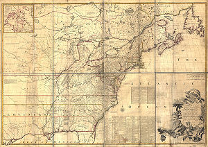
Mitchell Map
Encyclopedia
Map
A map is a visual representation of an area—a symbolic depiction highlighting relationships between elements of that space such as objects, regions, and themes....
made by John Mitchell
John Mitchell (geographer)
John Mitchell was a colonial American doctor and botanist. He created the most comprehensive and perhaps largest 18th-century map of eastern North America, known today as the Mitchell Map...
(1711–1768), which was reprinted several times during the second half of the 18th century. The Mitchell Map was used as a primary map source during the Treaty of Paris
Treaty of Paris (1783)
The Treaty of Paris, signed on September 3, 1783, ended the American Revolutionary War between Great Britain on the one hand and the United States of America and its allies on the other. The other combatant nations, France, Spain and the Dutch Republic had separate agreements; for details of...
for defining the boundaries of the newly independent United States
United States
The United States of America is a federal constitutional republic comprising fifty states and a federal district...
. The map remained important for resolving border disputes between the United States and Canada as recently as the 1980s dispute over the Gulf of Maine
Gulf of Maine
The Gulf of Maine is a large gulf of the Atlantic Ocean on the east coast of North America.It is delineated by Cape Cod at the eastern tip of Massachusetts in the southwest and Cape Sable at the southern tip of Nova Scotia in the northeast. It includes the entire coastlines of the U.S...
fisheries. The Mitchell Map is the most comprehensive map of eastern North America made during the colonial era. Its size is about 6.5 feet (2 m) wide by 4.5 feet (1.4 m) high.
John Mitchell's initiation as a map maker
John Mitchell was not a professional geographer or map maker. Son of a wealthy Virginian family in Lancaster County, on Virginia's Northern Neck, he had been educated at Edinburgh University, Scotland; this education included the first two years of the three-year medical program. Returning to coastal Virginia, he practiced as a physician and studied the local botany. Ill health forced Mitchell and his wife to leave Virginia for London in 1746. There, he served as a consultant on exotic plants to noblemen interested in gardens. Also, it was there that Mitchell would make his famous map. Map historians have understandably been interested in why a physician and botanist who had shown no previous interest in map making should make such a large and detailed map.Until recently, historians have explained Mitchell's cartographic turn in terms that implicitly support a rather nationalistic interpretation of U.S. history. Specifically, they have argued that Mitchell was upset by the lack of interest shown by politicians in London about colonial affairs and so set out to warn them about the dangers posed to the British colonies by the French. Mitchell did so, on his own initiative, by making a first map of North America in 1750, which he then showed to the politicians he knew through his botanical and gardening activities. The map so impressed George Montagu-Dunk, 2nd Earl of Halifax
George Montagu-Dunk, 2nd Earl of Halifax
George Montagu-Dunk, 2nd Earl of Halifax, KG, PC was a British statesman of the Georgian era.-Early life:...
, appointed president of the Board of Trade and Plantations
Board of Trade
The Board of Trade is a committee of the Privy Council of the United Kingdom, originating as a committee of inquiry in the 17th century and evolving gradually into a government department with a diverse range of functions...
in 1748, that Halifax opened up the official archives and solicited new maps from the colonies for Mitchell to make a new and better map. This was the map published in 1755. That is, the motive force for preparations against the French threat is understood to have come from a colonist who sought to take control of the colonies' future on behalf of the other colonists. (See, for example, the accounts by Ristow and Berkeley & Berkeley.)
A reexamination of the archival evidence indicates, however, that Mitchell made his first map in 1750 at Halifax's behest. Halifax became president of the Board of Trade
Board of Trade
The Board of Trade is a committee of the Privy Council of the United Kingdom, originating as a committee of inquiry in the 17th century and evolving gradually into a government department with a diverse range of functions...
directly after the conclusion of the War of the Austrian Succession
War of the Austrian Succession
The War of the Austrian Succession – including King George's War in North America, the Anglo-Spanish War of Jenkins' Ear, and two of the three Silesian wars – involved most of the powers of Europe over the question of Maria Theresa's succession to the realms of the House of Habsburg.The...
(1744–1748) and its North American component, King George's War
King George's War
King George's War is the name given to the operations in North America that formed part of the War of the Austrian Succession . It was the third of the four French and Indian Wars. It took place primarily in the British provinces of New York, Massachusetts Bay, New Hampshire, and Nova Scotia...
. The war had ended in stalemate and a return to the Anglo-French status quo of the 1714 Treaty of Utrecht
Treaty of Utrecht
The Treaty of Utrecht, which established the Peace of Utrecht, comprises a series of individual peace treaties, rather than a single document, signed by the belligerents in the War of Spanish Succession, in the Dutch city of Utrecht in March and April 1713...
. In fact, it was a common conviction that it was only a matter of time before another global Anglo-French war would begin, and it was commonly expected that the spark of the new conflict would be the North American colonies. It was then that Halifax latched onto Mitchell as an expert informant on all things colonial; one of his requests, apparently, was for Mitchell to make a new map to show the territorial situation in North America. Certainly, it was only after 1749 that Mitchell's correspondence revealed his new interests in both geography and politics. (See Edney 2008.)
The creation of the map
Mitchell compiled a first map in 1750 from the materials that he could find in London, in official archives and private hands. It proved to be inadequate. Halifax accordingly ordered the governors of the British colonies to send new maps, which most did. These became the basis, when fitted into the overall geographical frame provided by the maps of the French geographer Guillaume DelisleGuillaume Delisle
Guillaume Delisle was a French cartographer who lived in Paris.His father, Claude Delisle studied law and then later settled in Paris as private teacher in geography and history, and afterwards filled the office of royal censor...
. Late in 1754, Halifax was using one manuscript copy of Mitchell's second map to successfully promote his political position (no compromise with the French) within the British cabinet in the build-up to the Seven Years' War
Seven Years' War
The Seven Years' War was a global military war between 1756 and 1763, involving most of the great powers of the time and affecting Europe, North America, Central America, the West African coast, India, and the Philippines...
aka French and Indian War
French and Indian War
The French and Indian War is the common American name for the war between Great Britain and France in North America from 1754 to 1763. In 1756, the war erupted into the world-wide conflict known as the Seven Years' War and thus came to be regarded as the North American theater of that war...
. Halifax also permitted Mitchell to have the map published: it appeared in April 1755, engraved by Thomas Kitchin
Thomas Kitchin
Thomas Kitchin was an English engraver and map-maker, who became hydrographer to the king.-Life:He was born in Southwark, and was apprenticed to Emanuel Bowen in 1732. Originally based in Clerkenwell, by late 1755 Kitchin was established on Holborn Hill. From 1773 Kitchin was royal hydrographer...
and published by Andrew Millar
Andrew Millar
Andrew Millar was a British publisher.About 1729, he started business as a bookseller and publisher in the Strand, London. His own judgment in literary matters was small, but he collected an excellent staff of literary advisers, and did not hesitate to pay what at the time were considered large...
.
The published map bore the title "A Map of the British and French Dominions in North America." It bore the copyright date of 13 February 1755, but the map was probably not sold to the public until April or even May. Minor corrections to the map's printing plates were made probably during the printing process (for example, the name and address of the publisher were corrected).
The geographer John Green (né Braddock Mead) criticized Mitchell and his map soon after it appeared, emphasizing two failings with respect to Nova Scotia (an area of particular dispute with the French). Mitchell, Green noted, had used neither the astronomical observations for latitude and longitude made by Marquis Joseph Bernard de Chabert
Joseph Bernard de Chabert
Joseph Bernard, marquis de Chabert was a French sailor, geographer and astronomer.He marked himself out as a chef d'escadre during French involvement in the American War of Independence and was promoted to vice admiral in 1792...
in the 1740s nor a 1715 chart of the Nova Scotia coast. In response, Mitchell released a new version of his map, now with two large blocks of text that described all of his data sources; the new version of the map also adjusted the coastline in line with Chabert's work but rejected the 1715 chart as deeply flawed. This version of the map, which Mitchell referred to as the "second edition," is commonly thought to have appeared sometime in 1757, but advertisements in the (London) Public Advertiser and Gazetteer and London Daily Advertiser on 23 April 1756 clearly indicate that this new map appeared at that time.
The map continued to be corrected and some boundaries updated, even after Mitchell's death in 1768, as detailed in Edney (2007).
The map
Mitchell's map was printed in eight sheets; when assembled, it measures 136 cm by 195 cm (4 feet 6 inches by 6 feet 5 inches; height x width). The initial impressions printed in 1755 have a consistent coloring outlining British colonial claims. Mitchell extended the southern colonies across the entire continent, even over established Spanish territory west of the Mississippi. Mitchell divided up the Iroquois territories (as he understood them, reaching from Lake Champlain [Lac Irocoisia] to the Mississippi, and north of Lake Superior) between Virginia and New York, leaving only a much-reduced territory to the French.Mitchell's map was expensive but it spawned many cheaper variants that trumpeted Halifax and Mitchell's powerful colonial vision to the British public. One of these, published in December 1755 by "a Society of Anti-Gallicans", restricted the French even further just to Quebec.
The map is liberally sprinkled with text describing and explaining various features, especially in regions that were relatively unknown or which were subject to political dispute. Many notes describe the natural resources and potential for settlement of frontier regions. Others describe Indian tribes. Many Indian settlements are shown, along with important Indian trails.
Since Mitchell's main objective was to show the French threat to the British colonies, there is a very strong pro-British bias in the map, especially with regard to the Iroquois
Iroquois
The Iroquois , also known as the Haudenosaunee or the "People of the Longhouse", are an association of several tribes of indigenous people of North America...
. The map makes clear that the Iroquois were not just allies of Britain, but subjects, and that all Iroquois land was therefore British territory. Huge parts of the continent are noted as being British due to Iroquois conquest of one tribe or another. French activity within the Iroquois claimed lands are noted, explicitly or implicitly, as illegal.
The map is very large and the notes are often very small, making it difficult to view online. Reduced scale copies result in unreadable notes. The following list gives a few examples of the kind of notes found on the map, with Mitchell's spelling:
- The region of today's central Tennessee and Kentucky (between the Tennessee and Cumberland Rivers): A Fine Level Fertile Country of great Extent, by Accounts of the Indians and our People
- In the area between the Mississippi River and the Tennessee River: This Country of the Cherokees which extends Westward to the and Northward to the Confines of the Six Nations was formally surrendered to the Crown of Britain at Westminster 1729
- In the Great Plains: The Nadouessoians are reckoned one of the most Populous Nations of Indians in North America, altho' the number and situation of their Villages are not known nor laid down.
- Along the coast of the Gulf of Mexico, present-day Texas: Wandering Savage Indians
- Southwest of Hudson Bay: The long and Barbarous Names lately given to some of these Northern Parts of Canada and the Lakes we have not inserted, as they are of no use, and uncertain Authority.
- North of Lake Huron: MESSESAGUES - Subdued by the Iroquois and now united with them making the 8th Nation in that League. (reference to the MississaugasMississaugasThe Mississaugas are a subtribe of the Anishinaabe-speaking First Nations people located in southern Ontario, Canada. They are closely related to the Ojibwa...
)
- Missouri River: Missouri River is reckoned to run Westward to the Mountains of New Mexico, as far as the Ohio does Eastward
- Present-day Iowa: Extensive Meadows full of Buffaloes
- Sandusky, OhioSandusky, OhioSandusky is a city in the U.S. state of Ohio and the county seat of Erie County. It is located in northern Ohio and is situated on the shores of Lake Erie, almost exactly half-way between Toledo to the west and Cleveland to the east....
: Sandoski - Canahogue - The seat of War, the Mart of Trade, & chief Hunting Grounds of the Six Nations, on the Lakes & the Ohio.
- Central Pennsylvania, north of present-day HarrisburgHarrisburg, PennsylvaniaHarrisburg is the capital of Pennsylvania. As of the 2010 census, the city had a population of 49,528, making it the ninth largest city in Pennsylvania...
: St. Anthony's Wilderness
- Illinois region: The Antient Eriez were extirpated by the Iroquois upwards of 100 years ago, ever since which time they have been in of L. Erie (reference to the Erie (tribe)Erie (tribe)The Erie were an Native American people historically living on the south shore of Lake Erie. An Iroquoian group, they lived in what is now western New York, northwestern Pennsylvania, and northern Ohio...
)
- Along Illinois River and overland to the south end of Lake Michigan: Western Bounds of the Six Nations sold and Surrendered to Great Britain
- Illinois region: The Six Nations have extended their Territories to the River Illinois, ever since the Year 1672, when they subdued, and were incorporated with, the Antient Chaouanons, the Native Proprietors of these Countries, and the River Ohio. Besides which they likewise claim a Right of Conquest over the Illinois, and all the Mississippi as far as they extend. This is confirmed by their own Claims and Possessions in 1742, which include all the Bounds here laid down, and none have ever thought fit to dispute them. (reference to the IlliniwekIlliniwekThe Illinois Confederation, sometimes referred to as the Illiniwek or Illini, were a group of twelve to thirteen Native American tribes in the upper Mississippi River valley of North America...
)
- Just below the previous note: The Ohio Indians are a mixt Tribe of the Several Indians of our Colonies, settled here under the Six Nations, who have always been in Alliance and Subjection to the English. The most numerous of them are the Delaware and Shawnoes, who are Natives of Delaware River. Those about Philadelphia were called Sauwanoos whom we now call Shawanoes, or Shawnoes. The Mohickans and Minquaas were the Antient Inhabitants of Susquehanna R. (reference to the LenapeLenapeThe Lenape are an Algonquian group of Native Americans of the Northeastern Woodlands. They are also called Delaware Indians. As a result of the American Revolutionary War and later Indian removals from the eastern United States, today the main groups live in Canada, where they are enrolled in the...
, ShawneeShawneeThe Shawnee, Shaawanwaki, Shaawanooki and Shaawanowi lenaweeki, are an Algonquian-speaking people native to North America. Historically they inhabited the areas of Ohio, Virginia, West Virginia, Western Maryland, Kentucky, Indiana, and Pennsylvania...
, and SusquehannockSusquehannockThe Susquehannock people were Iroquoian-speaking Native Americans who lived in areas adjacent to the Susquehanna River and its tributaries from the southern part of what is now New York, through Pennsylvania, to the mouth of the Susquehanna in Maryland at the north end of the Chesapeake Bay...
Indians)
- Southeast Missouri area: Mines of Marameg, which gave rise to the famous Mississippi Scheme 1719Mississippi CompanyThe "Mississippi Company" became the "Company of the West" and expanded as the "Company of the Indies" .-The Banque Royale:...
.
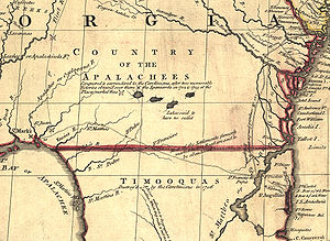
- North Florida: TIMOOQUA - Destroy'd by the Carolinians in 1706 (reference to the TimucuaTimucuaThe Timucua were a Native American people who lived in Northeast and North Central Florida and southeast Georgia. They were the largest indigenous group in that area and consisted of about 35 chiefdoms, many leading thousands of people. The various groups of Timucua spoke several dialects of the...
)
- South Georgia: COUNTRY OF THE APALACHEES - Conquered & surrendered to the Carolinians, after two memorable Victories obtain'd over them & the Spaniards in 1702 & 1703 at the Places marked thus [crossed-swords] (reference to the ApalacheeApalacheeThe Apalachee are a Native American people who historically lived in the Florida Panhandle, and now live primarily in the U.S. state of Louisiana. Their historical territory was known to the Spanish colonists as the Apalachee Province...
)
- Alabama area: The English have Factories & Settlements in all the Towns of the Creek Indians of any note, except Albamas; which was usurped by the French in 1715 but established by the English 28 years before. (reference to the Creek peopleCreek peopleThe Muscogee , also known as the Creek or Creeks, are a Native American people traditionally from the southeastern United States. Mvskoke is their name in traditional spelling. The modern Muscogee live primarily in Oklahoma, Alabama, Georgia, and Florida...
)
- Yazoo River: River of the Yasous - The Indians on this River were in Alliance with the English, for which they have been destroyed by the French (reference to the Yazoo tribeYazoo tribeThe Yazoo were a tribe of the Native American Tunica people historically located on the lower course of Yazoo River, Mississippi. It was closely connected to other Tunica peoples, especially the Tunica, Koroa, and possibly the Tioux....
)
Many geographic features are labeled with names no longer in use or oddly spelled, including:
- Kanawha and New River together: Gr. Conhaway called Wood R. or New R.
- Kentucky River: Cuttawa or Catawba R.
- Clinch River: Pelisipi River (a tributary is labeled Clinch's R.)
- Tennessee River: River of the Cherakees, or Hogohegee R. Upstream another label says River Hogohegee or Callamaco
- French Broad River: Agiqua R.
- Little Tennessee River: Tannaſsee or Satico R.
- Hiwassee River: Euphasee
- Ohio River: Ohio or Splawacipiki R.
- Altamaha River: Alatamaha or George R.
- Minnesota River: Ouadebameniſsouté or R. St. Peter (reflecting the Dakota name Watpá Mnísota and the French name Rivière de St. Pierre)
The map also included non-existent features such as Isles Phelipeaux and Pontchartrain
Isles Phelipeaux and Pontchartrain
Isle Phelipeaux and Isle Pontchartrain are phantom islands inLake Superior, believed at one time to be real, shown on early maps, such as the Mitchell Map, of...
in Lake Superior.
Use at the Treaty of Paris
The Mitchell Map remained the most detailed map of North America available in the later eighteenth century. Various impressions (and also French copies) were directly used to help establish the boundaries of the new United States of America by diplomats at the Treaty of Paris (1783)Treaty of Paris (1783)
The Treaty of Paris, signed on September 3, 1783, ended the American Revolutionary War between Great Britain on the one hand and the United States of America and its allies on the other. The other combatant nations, France, Spain and the Dutch Republic had separate agreements; for details of...
that ended the American Revolutionary War
American Revolutionary War
The American Revolutionary War , the American War of Independence, or simply the Revolutionary War, began as a war between the Kingdom of Great Britain and thirteen British colonies in North America, and ended in a global war between several European great powers.The war was the result of the...
. The map's inaccuracies inevitably led subsequently to a number of border disputes, particularly in Maine and near the source of the Mississippi River.
Webster-Ashburton Treaty
It was not until 1842, with the signing of the Webster-Ashburton TreatyWebster-Ashburton Treaty
The Webster–Ashburton Treaty, signed August 9, 1842, was a treaty resolving several border issues between the United States and the British North American colonies...
, that the U.S.-Canadian border was clearly drawn from Maine
Maine
Maine is a state in the New England region of the northeastern United States, bordered by the Atlantic Ocean to the east and south, New Hampshire to the west, and the Canadian provinces of Quebec to the northwest and New Brunswick to the northeast. Maine is both the northernmost and easternmost...
to the Oregon Country
Oregon Country
The Oregon Country was a predominantly American term referring to a disputed ownership region of the Pacific Northwest of North America. The region was occupied by British and French Canadian fur traders from before 1810, and American settlers from the mid-1830s, with its coastal areas north from...
. This finally ended ambiguities resulting from use of the map to define American territory at the end of the Revolution.