
Weather STAR 4000
Encyclopedia
The Weather Star 4000 is the first graphic-capable model of the WeatherStar
line manufactured for The Weather Channel
. It was first introduced in December 1989 and was designed by Canadian electronics company Amirix (then the Applied Microelectronics Institute). The WeatherStar 4000 was manufactured by Northern Telecom. It had an improved display font over its predecessor, the Weather Star III
, with mixed-case (though this didn't appear on launch). The first 4000s that were placed in service were programmed to operate in a text-only mode, like its predecessors (using its improved font instead). However, the 4000 used slightly different flavors (arrangements of information and forecast products) that included, beginning in April 1990, a graphical radar page at the end of the local forecast. While widely used during most of the 1990s, many cable companies began to replace the 4000 with the newer Weather Star XL
in 1998 and 1999 and - later - the IntelliStar
in the next decade. The 4000 remains in use primarily in smaller and rural cable providers where upgrading to a more modern Weather Star would be a significant expense.
The Weather Star 4000 also was deployed in Canada by The Weather Network
and its French-language sister MétéoMédia
from 1992 to 1997, when owner Pelmorex replaced it with its proprietary PMX
system. The Weather Star 4000 displayed various products in Canada that were never available in the U.S.
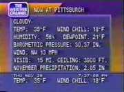
Also, until the mid 1990s, The Weather Channel sold an optional sensor package that could be connected to a Weather Star to display weather conditions at the headend office on the LDL, including the current temperature, the highest and lowest temperatures recorded since midnight, relative humidity, wind speed, direction, and gusts, and current daily and monthly precipitation totals. As of 2009, two remaining 4000's have been found that still use a sensor package, Tucumari New Mexico, and Spearfish South Dakota .
Radar products are/were not available on the Weather Star 4000 outside of the contiguous 48 states and Puerto Rico.
Sources:
Analog refers to the station's Analog channel. VC refers to the station's digital PSIP virtual channel
. RF refers to the station's physical digital RF channel.
A product playlist (commonly referred to as a flavor) is an arrangement of information and forecast products. The radar's positions in the local forecast playlists are shown in bold text.
| bgcolor="dodgerblue"| indicates flavors with Current Radar.
| bgcolor="red"| indicates flavors with Local Radar.
(flavors marked with LU feature a "Local Update")
and its French-language sister station MétéoMedia
in 1992. It has its own distinctive history.
WeatherStar
WeatherStar refers to the technology used by The Weather Channel to generate their Local Forecast segments on cable TV systems nationwide...
line manufactured for The Weather Channel
The Weather Channel
The Weather Channel is a US cable and satellite television network since May 2, 1982, that broadcasts weather forecasts and weather-related news, along with entertainment programming related to weather 24 hours a day...
. It was first introduced in December 1989 and was designed by Canadian electronics company Amirix (then the Applied Microelectronics Institute). The WeatherStar 4000 was manufactured by Northern Telecom. It had an improved display font over its predecessor, the Weather Star III
Weather Star III
The Weather Star III is one in a series of systems from The Weather Channel that use data from satellite systems and organize it for broadcasting. Introduced in 1986, it was a major hardware upgrade over the Weather Star II...
, with mixed-case (though this didn't appear on launch). The first 4000s that were placed in service were programmed to operate in a text-only mode, like its predecessors (using its improved font instead). However, the 4000 used slightly different flavors (arrangements of information and forecast products) that included, beginning in April 1990, a graphical radar page at the end of the local forecast. While widely used during most of the 1990s, many cable companies began to replace the 4000 with the newer Weather Star XL
Weather STAR XL
Weather Star XL is the fifth system designed for The Weather Channel's local forecast. At its rollout in 1998, it came months after a major update to the channel's presentation. The Star XL was a major leap over the much older Weather Star 4000 system, featuring advanced capabilities such as...
in 1998 and 1999 and - later - the IntelliStar
IntelliStar
IntelliStar is the fifth generation successor to the WeatherStar systems used by the American cable TV and satellite TV channel The Weather Channel , for inserting local forecasts and current weather information into TWC's programming...
in the next decade. The 4000 remains in use primarily in smaller and rural cable providers where upgrading to a more modern Weather Star would be a significant expense.
The Weather Star 4000 also was deployed in Canada by The Weather Network
The Weather Network
The Weather Network is a Canadian English language Category A specialty channel that broadcasts weather-related news and information 24 hours a day....
and its French-language sister MétéoMédia
MétéoMédia
MétéoMédia is a 24-hour Canadian French language Category A specialty channel and web site, which provides weather information 24 hours a day. It primarily serves viewers in Quebec, although some cable TV systems in Ontario and New Brunswick carry the channel as well. It is available nation-wide...
from 1992 to 1997, when owner Pelmorex replaced it with its proprietary PMX
PMX (technology)
PMX refers to the technology developed by Pelmorex to generate local weather information on The Weather Network. PMX consists of computers, typically installed at a cable headend, that takes data fed to it and packages it for broadcast...
system. The Weather Star 4000 displayed various products in Canada that were never available in the U.S.
Standard features
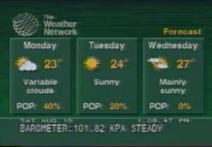
A Weather Star 4000 came with these features:- Graphical weather products, such as icons and maps for regional products.
- An internal local radar product (the first on any STAR), in both time-lapse and static variants. (The time-lapse radar was added in a major late 1992 update. The previous Weather Stars had the capability to display radar, but had to be connected to a third-party source.)
- The ability to receive text-based local forecasts created by TWC meteorologists (and before that the National Weather Service).
- A lower display line (LDL), with forecast information in the top 50 US markets. While the IntelliStar LDL is cued to air all the time, the 4000, Junior, and XL LDLs are not cued to air anymore except with a cuing messup.
- The ability to crawl or scroll weather warnings from the National Weather Service.
- Specialty products for certain areas: the Air Quality Forecast for southern California (which would make its national debut on the IntelliStar), Tides for coastal areas, and the Marine Forecast.
Also, until the mid 1990s, The Weather Channel sold an optional sensor package that could be connected to a Weather Star to display weather conditions at the headend office on the LDL, including the current temperature, the highest and lowest temperatures recorded since midnight, relative humidity, wind speed, direction, and gusts, and current daily and monthly precipitation totals. As of 2009, two remaining 4000's have been found that still use a sensor package, Tucumari New Mexico, and Spearfish South Dakota .
Radar products are/were not available on the Weather Star 4000 outside of the contiguous 48 states and Puerto Rico.
- In Alaska and (in one case) in New York City, the Latest Observations product was repeated.
- In Hawaii, the radar was centered in the state of Washington with a label permanently displaying "Radar Data Temporarily Unavailable".
Weather Star 4000 timeline in the U.S.
1990
- Early - In these early days, the 4000 was functionally a replica of the Weather Star IIIWeather Star IIIThe Weather Star III is one in a series of systems from The Weather Channel that use data from satellite systems and organize it for broadcasting. Introduced in 1986, it was a major hardware upgrade over the Weather Star II...
, only with a cleaner font. - April - The "Current Radar" segment was added to the 4000, making it the first STAR with its own radar. At this time, the segment was called "Your Local Radar".
- July - WeatherStar 4000 gets new graphics featuring colorful orange and blueBlueBlue is a colour, the perception of which is evoked by light having a spectrum dominated by energy with a wavelength of roughly 440–490 nm. It is considered one of the additive primary colours. On the HSV Colour Wheel, the complement of blue is yellow; that is, a colour corresponding to an equal...
backgrounds matching TWC's national weather segments at the time. The Weather Channel's logo appears on the local forecast for the first time, and the "Regional Forecast" map debut with motionless weather icons. The time and date appear on the LDL (Lower Display Line).
1991
- Early - The 5 minute N flavor local forecast, which was shown when TWC rewound the tapes for its prerecorded overnight programming, is discontinued.
- February 14 - The L flavor local forecast is born, the graphical version of the "Extended Forecast" segment is created, replacing the former NWSNational Weather ServiceThe National Weather Service , once known as the Weather Bureau, is one of the six scientific agencies that make up the National Oceanic and Atmospheric Administration of the United States government...
text based version. "Almanac" (formerly "Regional Information") data is redesigned to show the moon phases. The E and K flavors' screen line-ups are re-timed now that the "Extended Forecast" segment is 1 graphical page instead of 2 text-based pages. Because of this, the narration of TWC staff announcer Dan Chandler is discontinued on these two flavors. The regional weather icons became animated. The current radar is updated to include major roads. The time and date are moved to the top right from the lower display line. - April 17 - Weather icons make their way to the "Current Conditions" segment; however, they are very large and lack a nighttime set.
- May - The "Current Conditions" segment is finalized.
- July - Chandler re-records the narration for the Weather Star 4000; the E and K flavors' narration is once again restored.
- Late - The Regional Conditions map was created replacing the text-based page of the same name. The "Regional Forecast" map is cleaned up so that no city's information runs off screen. The icons used on the Regional Conditions and the Extended Forecast pages make their way to the regional map products. The Current Radar map is updated to include county boundaries.
1992
- Summer - The fade effect transitioning to and from the Regional Forecast product is removed. A second, more opaque dark blue to orange gradient background begins to appear layered over the existing dark blue to orange gradient background to smooth out the color transitions.
- August 9 - A new playlist debuts on The Weather Channel, with redone narration on all STARs (Dan Chandler's final set). The 36 Hour Forecast narration now mentions the National Weather Service.
- Fall - The Regional Forecast product icons return after a hiatus, during which they received a major revamp.
- November - A major change in flavors occurs. The "Local Radar" map is added, showing any precipitation in the area and its movement over 90 minutes. The "Travel Cities Forecast" segment becomes icon-based with a blue/aqua blue gradient background, and the NOAANational Oceanic and Atmospheric AdministrationThe National Oceanic and Atmospheric Administration , pronounced , like "noah", is a scientific agency within the United States Department of Commerce focused on the conditions of the oceans and the atmosphere...
logo is added to the "36 Hour Forecast" product.
1993
- October - The Regional Conditions map replaces the "Regional Forecast" during the K Flavor and Dan Chandler updates the narration on the flavor.
- Early November - The date and time are nudged further downward to make better room for the local forecast screen segment titles.
- Second half - Observation site names nationwide are simplified (such as New Orleans Intl becoming New Orleans) and begin to appear in mixed case. The Latest Observations product receives the new observation site names and mixed-case weather descriptors. Some of these changes to observation site names appear on the ticker before the actual products. Other times, the Latest Observations product would have all uppercase text except for the observation sites.
1994
- Early - The Weather Channel begins broadcasting regional commercials that can be blocked out by local forecasts generated by a Weather Star. Local Forecasts with lengths of 1:30 and 2:30 do the blocking of these 30-second commercials. STARs using non-narration audio would play this commercial audio. This was used in the summer of 1994 to advertise a TWC telephone survey about the satellite forecast for satellite customers.
- Spring - The regional icons are updated so that the multi-layered icons are smaller in size; the upper layer cloud moved almost directly on top of its underlying weather graphic.
- August 4 - "Travel Cities Forecast" background gradient is removed, and the Radar map screen becomes eight colors from its previous six-color graphics.
1995
- Early - Some of the icons on the Regional Icon set are changed, such as "Snow" and others are added, such as "Sunny and Windy."
- April 2 - Flavor line-ups are changed once again as the "30 Day Outlook" is discontinued by the National Weather Service (and thus TWC) and the "Local Update" segment is introduced from the National Weather Service as generated by the WeatherStarWeatherStarWeatherStar refers to the technology used by The Weather Channel to generate their Local Forecast segments on cable TV systems nationwide...
, which took more than one screen. It gave a summary of what was occurring and what would occur over the next few hours. Dan Chandler's narration is discontinued. A Severe Weather Mode is also added to the 4000. If a severe weather warning crawl is present, a special playlist would play consisting of only current and local area conditions and an extended local radar.
1998
- Early - The J flavor is discontinued when the Travel Cities Forecast is dropped and only appears when The Weather Channel is experiencing some minor or major technical difficulties (the Travel Cities Forecast was not dropped on the Weather Star IIIWeather Star IIIThe Weather Star III is one in a series of systems from The Weather Channel that use data from satellite systems and organize it for broadcasting. Introduced in 1986, it was a major hardware upgrade over the Weather Star II...
and is still used in the Weather Star Jr's M flavor). - September - The first signs of graphical system degradationDegradation (telecommunications)In telecommunication, degradation, which may be categorized as either "graceful" or "catastrophic", has the following meanings:#The deterioration in quality, level, or standard of performance of a functional unit....
, are reported, with patchy reports from as early as 1997. Later signs of degradation reported consist of bit rotBit rotBit rot, also known as bit decay, data rot, or data decay, is a colloquial computing term used to describe either a gradual decay of storage media or the degradation of a software program over time. The latter use of the term implies that software can wear out or rust like a physical tool...
, including problems, such as the new moon graphic on the Almanac changing colors or the Local Radar's background becoming inverted. These problems are attributed to the age of the graphics rendering hardware, as well as integrity issues with the on-board EEPROMEEPROMEEPROM stands for Electrically Erasable Programmable Read-Only Memory and is a type of non-volatile memory used in computers and other electronic devices to store small amounts of data that must be saved when power is removed, e.g., calibration...
's.
1999
- December - By this time, most cable headends have upgraded to the Weather Star XLWeather STAR XLWeather Star XL is the fifth system designed for The Weather Channel's local forecast. At its rollout in 1998, it came months after a major update to the channel's presentation. The Star XL was a major leap over the much older Weather Star 4000 system, featuring advanced capabilities such as...
, however some companies still use the 4000. - December - The Weather Channel logo is modernized, and the point size of the fonts in the Local and Current Radar screens become smaller. The font in the titles of the radar segments were changed from HelveticaHelveticaHelvetica is a widely used sans-serif typeface developed in 1957 by Swiss typeface designer Max Miedinger with Eduard Hoffmann.-Visual distinctive characteristics:Characteristics of this typeface are:lower case:square dot over the letter i....
to ArialArialArial, sometimes marketed or displayed in software as Arial MT, is a sans-serif typeface and set of computer fonts. Fonts from the Arial family are packaged with Microsoft Windows, some other Microsoft software applications, Apple Mac OS X and many PostScript 3 computer printers...
.
2002
- November - The 36 Hour Forecast begins to come directly from The Weather Channel and appears in mixed case. The Local Update is discontinued, stabilizing each flavor. The Marine Forecast is also discontinued.
2005
- Early - Text used on the Station ID became bolder and larger. Some of the old text is still in use up through August 2005.
Cable headends utilizing the Weather Star 4000
Below is a list of 4000s that are still in use.Sources:
Analog refers to the station's Analog channel. VC refers to the station's digital PSIP virtual channel
Virtual channel
In telecommunications, a logical channel number , also known as virtual channel, is a channel designation which differs from that of the actual radio channel on which the signal travels....
. RF refers to the station's physical digital RF channel.
| City/town | Primary observation site | Cable company/headend | Analog | VC | RF | STAR ID | Notes |
|---|---|---|---|---|---|---|---|
| Auburn University Auburn University Auburn University is a public university located in Auburn, Alabama, United States. With more than 25,000 students and 1,200 faculty members, it is one of the largest universities in the state. Auburn was chartered on February 7, 1856, as the East Alabama Male College, a private liberal arts... , Alabama Alabama Alabama is a state located in the southeastern region of the United States. It is bordered by Tennessee to the north, Georgia to the east, Florida and the Gulf of Mexico to the south, and Mississippi to the west. Alabama ranks 30th in total land area and ranks second in the size of its inland... |
Auburn, Alabama Auburn, Alabama Auburn is a city in Lee County, Alabama, United States. It is the largest city in eastern Alabama with a 2010 population of 53,380. It is a principal city of the Auburn-Opelika Metropolitan Area... |
Auburn University campus cable | No degradation | ||||
| Troy, Alabama Troy, Alabama Troy is a city in Pike County, Alabama, United States. As of the 2010 census, the population was 18,003. Troy experienced a growth spurt of over 4,000+ people since 2000. The city is the county seat of Pike County.... |
Cairns Airfield | Troy Cable | Used as a backup unit if the Weather Star XL Weather STAR XL Weather Star XL is the fifth system designed for The Weather Channel's local forecast. At its rollout in 1998, it came months after a major update to the channel's presentation. The Star XL was a major leap over the much older Weather Star 4000 system, featuring advanced capabilities such as... should fail. |
||||
| Blytheville, Arkansas Blytheville, Arkansas Blytheville is the largest city in and one of the two county seats of Mississippi County, Arkansas, United States. The population was 15,620 at the 2010 census.... |
Ritter Communications | ||||||
| Fairfield Bay, Arkansas Fairfield Bay, Arkansas Fairfield Bay is a city in Cleburne and Van Buren counties in the northern part of the U.S. state of Arkansas. The population was 2,460 at the 2000 census... |
Ritter Communications | ||||||
| Marked Tree, Arkansas Marked Tree, Arkansas Marked Tree is a city in Poinsett County, Arkansas in the United States, along the St. Francis River, at the mouth of the Little River. The population was 2,800 at the 2000 census. It is included in the Jonesboro, Arkansas Metropolitan Statistical Area.... |
Ritter Communications | ||||||
| Pine Bluff, Arkansas Pine Bluff, Arkansas Pine Bluff is the largest city and county seat of Jefferson County, Arkansas, United States. It is also the principal city of the Pine Bluff Metropolitan Statistical Area and part of the Little Rock-North Little Rock-Pine Bluff, Arkansas Combined Statistical Area... |
Pine Bluff, Arkansas | Suddenlink | 15 | 3042 | |||
| Tahoe City, California Tahoe City, California Tahoe City is an unincorporated community in Placer County, California. Tahoe City is located on Lake Tahoe, southeast of Donner Pass. It lies at an elevation of 6250 feet .... |
Truckee, California Truckee, California Truckee is an incorporated town in Nevada County, California, United States. The population was 16,180 at the 2010 census, up from 13,864 at the 2000 census.-Name:... |
WestStar Cable | Last confirmed in 2008, one of the last working 4000s in California. | ||||
| Port Hueneme, California Port Hueneme, California Port Hueneme is a small beach city in Ventura County, California surrounded by the city of Oxnard and the Pacific Ocean. The name derives from the Spanish spelling of the Chumash wene me, meaning "Resting Place". The area was discovered by Juan Rodríguez Cabrillo in the mid 16th century... |
Point Mugu NAS, California Naval Air Station Point Mugu Naval Base Ventura County Point Mugu or NBVC Point Mugu is a military airbase located in Point Mugu, Ventura County, California, United States. Due to realignment actions which occurred in 2000, the base is now part of Naval Base Ventura County , a consolidated organization that also includes... |
Communication Services Cable | 25 | As of May 2011, one of the last working 4000s in California. | |||
| Astatula, Florida Astatula, Florida Astatula is a town in Lake County, Florida, United States. The population was 1,298 at the 2000 census. The Census Bureau estimated the population in 2008 to be 1,831... |
Leesburg, Florida Leesburg, Florida Leesburg is a city in Lake County, Florida, United States. The population was 15,956 at the 2000 census. As of 2005, the population recorded by the U.S. Census Bureau is 19,086.. Leesburg is located in central Florida, between Lake Harris and Lake Griffin, at the head of the Oklawaha River system.... |
Florida Cable | 13 | No signs of degradation currently present. | |||
| Mexico Beach, Florida Mexico Beach, Florida Mexico Beach is a city in Bay County, Florida, United States. The population was 1,072 at the 2010 census. . It is part of the Panama City–Lynn Haven–Panama City Beach Metropolitan Statistical Area.-Geography:Mexico Beach is located at .... |
Panama City, Florida Panama City, Florida -Personal income:The median income for a household in the city was $31,572, and the median income for a family was $40,890. Males had a median income of $30,401 versus $21,431 for females. The per capita income for the city was $17,830... |
Mediacom Mediacom Mediacom is a cable television and communications provider in the United States. Founded in July 1995, it serves primarily smaller markets in the Midwest and Southern United States. Formerly a publicly traded firm, it went private in a $600.0 million transaction in March 2011 and is, as of 2011,... |
27 | 1323 | |||
| Springfield, Florida Springfield, Florida Springfield is a city in Bay County, Florida, United States, east of Panama City. The population was 8,903 at the 2010 census. . It is part of the Panama City–Lynn Haven–Panama City Beach Metropolitan Statistical Area. Springfield was incorporated on February 12, 1935... |
Panama City, Florida | Springfield Cablevision | |||||
| Pensacola, Florida Pensacola, Florida Pensacola is the westernmost city in the Florida Panhandle and the county seat of Escambia County, Florida, United States of America. As of the 2000 census, the city had a total population of 56,255 and as of 2009, the estimated population was 53,752... |
Mediacom Mediacom Mediacom is a cable television and communications provider in the United States. Founded in July 1995, it serves primarily smaller markets in the Midwest and Southern United States. Formerly a publicly traded firm, it went private in a $600.0 million transaction in March 2011 and is, as of 2011,... |
||||||
| Belleville, Illinois Belleville, Illinois Belleville is a city in St. Clair County, Illinois, United States. As of the 2010 census, the city has a population of 44,478. It is the eighth-most populated city outside of the Chicago Metropolitan Area and the most populated city south of Springfield in the state of Illinois. It is the county... |
Belleville, Illinois | Charter Communications Charter Communications Charter Communications is an American company providing cable television, high-speed Internet, and telephone services to more than 4.7 million customers in 25 states. By revenues, it is the fourth-largest cable operator in the United States, behind Comcast, Time Warner Cable, and Cox Communications... |
28 | No degradation exists on this unit. | |||
| Bellevue, Illinois Bellevue, Illinois Bellevue is a village in Peoria County, Illinois, United States. The population was 1,887 at the 2000 census. Bellevue is a suburb of Peoria and is part of the Peoria, Illinois Metropolitan Statistical Area.-Geography:... |
Tele-Star? | 14 | No signs of degradation Degradation (telecommunications) In telecommunication, degradation, which may be categorized as either "graceful" or "catastrophic", has the following meanings:#The deterioration in quality, level, or standard of performance of a functional unit.... |
||||
| Litchfield, Illinois Litchfield, Illinois Litchfield is a city in Montgomery County, Illinois, United States. The population was 6,815 at the 2000 census, and 6,588 in 2009. It is located in south central Illinois, south of Springfield and on the northern edge of the Greater St. Louis Metro-East area.-Attractions:The Ariston Cafe is one of... |
Litchfield, Illinois Alton, Illinois Alton, Illinois Alton is a city on the Mississippi River in Madison County, Illinois, United States, about north of St. Louis, Missouri. The population was 27,865 at the 2010 census. It is a part of the Metro-East region of the Greater St. Louis metropolitan area in Southern Illinois... (backup) St. Louis, Missouri St. Louis, Missouri St. Louis is an independent city on the eastern border of Missouri, United States. With a population of 319,294, it was the 58th-largest U.S. city at the 2010 U.S. Census. The Greater St... (backup) |
Charter/NewWave Communications | 20 | Last confirmed as of March 2010 | |||
| Metropolis, Illinois Metropolis, Illinois Metropolis is a city located along the Ohio River in Massac County, Illinois, in the United States. As of the 2000 census, the city population was 6,482... |
Paducah, Kentucky Paducah, Kentucky Paducah is the largest city in Kentucky's Jackson Purchase Region and the county seat of McCracken County, Kentucky, United States. It is located at the confluence of the Tennessee River and the Ohio River, halfway between the metropolitan areas of St. Louis, Missouri, to the west and Nashville,... |
Charter Communications | 27 | ||||
| Morris, Illinois Morris, Illinois Morris is a city in Grundy County, Illinois, United States. The population was 13,636 at the 2010 census.Morris is home to the Dresden Nuclear Power Plant, which provides a substantial portion of the electricity supply for the Chicago metropolitan area... |
Morris, Illinois | ||||||
| Churdan, Iowa Churdan, Iowa Churdan is a city in Greene County, Iowa, United States. The population was 418 at the 2000 census. It also has one of the last WeatherSTAR 4000 in the country.-Geography:Churdan is located at .... |
Fort Dodge, Iowa Fort Dodge, Iowa Fort Dodge is a city and county seat of Webster County, Iowa, United States, along the Des Moines River. The population was 25,206 in the 2010 census, an increase from 25,136 in the 2000 census. Fort Dodge is a major commercial center for North Central and Northwest Iowa. It is located on U.S... |
Gowrie Cablevision | 18 | Has trouble showing moon phases. | |||
| Monona, Iowa Monona, Iowa Monona is a city in Clayton County, Iowa, United States. The population was 1,550 at the 2000 census.-Geography:Monona is located at .According to the United States Census Bureau, the city has a total area of , all of it land.... |
Dubuque, Iowa | Northeast Iowa Telephone Company | 8 | ||||
| Perry, Kansas Perry, Kansas Perry is a city in Jefferson County, Kansas, United States. The population was 901 at the 2000 census. It is part of the Topeka, Kansas Metropolitan Statistical Area.-History:... Lecompton, Kansas Lecompton, Kansas Lecompton is a city in Douglas County, Kansas, United States. It is part of the Lawrence, Kansas Metropolitan Statistical Area. The population was 608 at the 2000 census. Lecompton played a major historical role in pre-Civil War America as the Territorial capital of Kansas from 1855 to 1861... |
Topeka, Kansas Topeka, Kansas Topeka |Kansa]]: Tó Pee Kuh) is the capital city of the U.S. state of Kansas and the county seat of Shawnee County. It is situated along the Kansas River in the central part of Shawnee County, located in northeast Kansas, in the Central United States. As of the 2010 census, the city population was... |
SCI Cable Inc. | 51 | Repaired a few years ago to fix severe degradation (radar issues and major legibility issues), so it appears as a brand new 4000. | |||
| Wamego, Kansas Wamego, Kansas Wamego is a city in Pottawatomie County, Kansas, United States. The population was 4,246 at the 2000 census. It is part of the Manhattan, Kansas Metropolitan Statistical Area.-Geography:Wamego is located at... |
WTC Communications | ||||||
| Fort Polk, Louisiana | Fort Polk, Louisiana | Suddenlink | 27 | ||||
| Bel Air, Maryland Bel Air, Harford County, Maryland The town of Bel Air is the county seat of Harford County, Maryland, United States. According to the 2000 census the population of the town was 10,080. In 2009 the town's estimated population was 10,368... |
Baltimore, Maryland | Armstrong Armstrong Telephone Company Armstrong Telephone Company is a telecommunications provider, and part of the Armstrong Group of Companies. The company primarily operates as a local exchange carrier in rural markets in West Virginia, Maryland, Pennsylvania and New York.-External links:*... |
3 | This unit has some slight degradation Degradation (telecommunications) In telecommunication, degradation, which may be categorized as either "graceful" or "catastrophic", has the following meanings:#The deterioration in quality, level, or standard of performance of a functional unit.... and has recently experienced garbled text. |
|||
| Mackinac Island, Michigan Mackinac Island, Michigan Mackinac Island is a city in Mackinac County in the U.S. state of Michigan. In the 2010 census, the city had a permanent population of 492, although there are thousands more seasonal workers and tourists during the summer months. From 1818–1882, the city was the county seat of the former... |
Mackinac Island, Michigan Mackinac Island, Michigan Mackinac Island is a city in Mackinac County in the U.S. state of Michigan. In the 2010 census, the city had a permanent population of 492, although there are thousands more seasonal workers and tourists during the summer months. From 1818–1882, the city was the county seat of the former... |
Charter Communications Charter Communications Charter Communications is an American company providing cable television, high-speed Internet, and telephone services to more than 4.7 million customers in 25 states. By revenues, it is the fourth-largest cable operator in the United States, behind Comcast, Time Warner Cable, and Cox Communications... |
As of June 29, 2011, this system has slight degradation on the radar. The green "dragon" symbol appears on the new moon. | ||||
| Yale, Michigan Yale, Michigan Yale is a city in St. Clair County in the U.S. state of Michigan. The population was 2,063 at the 2000 census. Yale is considered unofficially as the Bologna Capital of the world, in part due to its . Yale bologna is sold in grocery stores throughout the area. Yale is also home to the Yale... |
Port Huron, Michigan Port Huron, Michigan Port Huron is a city in the U.S. state of Michigan and the county seat of St. Clair County. The population was 30,184 at the 2010 census. The city is adjacent to Port Huron Township but is administratively autonomous. It is joined by the Blue Water Bridge over the St. Clair River to Sarnia,... |
Comcast Comcast Comcast Corporation is the largest cable operator, home Internet service provider, and fourth largest home telephone service provider in the United States, providing cable television, broadband Internet, and telephone service to both residential and commercial customers in 39 states and the... |
31 | Has some degree of degradation. The almanac shows the green "dragon" on new moon symbols. It is currently unclear where the headend that serves this area is actually located. It is possible that Yale is also served by the same headend that Bad Axe to the north is. In which case, this area could be served by an XL. Last confirmed in 2005. | |||
| Muskegon, Michigan Muskegon, Michigan Muskegon is a city in the U.S. state of Michigan. As of the 2010 census, the city population was 38,401. The city is the county seat of Muskegon County... |
Muskegon, Michigan | Glen Oaks Apartment Cable System | 34 | ||||
| Alexandria, Minnesota Alexandria, Minnesota As of the census of 2000, there were 8,820 people, however the most recent count suggests a population upwards of 10,000, which is displayed on Alexandria's city limits signs. The census lists 4,047 households, and 2,011 families residing in the city. The population density was 992.5 people per... |
Alexandria, Minnesota | Selective TV Inc. | 50 | 6216 | See K50DB K50DB K50DB is a low-powered television station in Alexandria, Minnesota. It is owned by Selective TV, Inc. , and it broadcasts on channel 50. It is one of two rebroadcasters of The Weather Channel using an over-the-air signal, the other being unrelated K34HO in nearby Willmar... : over the air broadcast in a UHF cable system. No degradation. |
||
| Warroad, Minnesota Warroad, Minnesota As of the census of 2000, there were 1,722 people, 657 households, and 419 families residing in the city. The population density was . There were 766 housing units at an average density of . The racial makeup of the city was 81.65% White, 0.29% Black or African American, 7.38% Native American,... |
Warroad, Minnesota | ||||||
| Willmar, Minnesota Willmar, Minnesota As of the census of 2000, there were 18,351 people, 7,302 households, and 4,461 families residing in the city. The population density was 1,549.9 people per square mile . There were 7,789 housing units at an average density of 657.8 per square mile... |
Willmar, Minnesota | UHF-TV Inc. UHF-TV Inc. UHF-TV Inc. is a low-powered television broadcaster which relays stations to people in the Willmar, Minnesota area.The station lineup is as follows:The other main stations in the area are:... |
34.1 | 34 | See K34HO K34HO K34HO-D is a low-powered station in Willmar, Minnesota affiliated with The Weather Channel. This station is owned and operated by UHF-TV Inc, which offers The Weather Channel as part of a limited line-up of cable and broadcast channels to Willmar-area viewers... : over the air broadcast in a UHF cable system. No degradation. |
||
| Brookfield, Missouri Brookfield, Missouri Brookfield is a city in Linn County, Missouri, United States. The population was 4,542 at the 2010 census.-Geography:Brookfield is located at .... |
|||||||
| Kirksville, Missouri Kirksville, Missouri Kirksville is the county seat of Adair County, Missouri, United States. It is located in Benton Township. The population was 17,505 at the 2010 census. Kirksville also anchors a micropolitan area that comprises Adair and Schuyler counties. The city is perhaps best known as the location of Truman... |
Kirksville, Missouri | CableOne | |||||
| West Plains, Missouri West Plains, Missouri West Plains is a city in Howell County, Missouri, United States. The population was 10,866 at the 2000 census. It is the county seat of Howell County. The West Plains Micropolitan Statistical Area consists of Howell County.-Geography:... |
Pomona, Missouri Pomona, Missouri Pomona is an unincorporated community in Howell County, Missouri, United States, midway between Willow Springs and West Plains. The community was founded in 1895 and it was named for Pomona, the Roman goddess of fruit trees; this area was a major producer of apples. Several homes, small... |
Charter Communications Charter Communications Charter Communications is an American company providing cable television, high-speed Internet, and telephone services to more than 4.7 million customers in 25 states. By revenues, it is the fourth-largest cable operator in the United States, behind Comcast, Time Warner Cable, and Cox Communications... |
No degradation. Last confirmed on May 27, 2010. | ||||
| Wolf Point, Montana Wolf Point, Montana Wolf Point is a city in and the county seat of Roosevelt County, Montana, United States. The population was 2,621 at the 2010 census. It is the largest community on the Fort Peck Indian Reservation. Wolf Point is the home of the annual Wild Horse Stampede, held every year during the second weekend... |
Wolf Point, Montana | ||||||
| Chadron, Nebraska Chadron, Nebraska Chadron is a city in Dawes County, Nebraska, United States. The population was 5,851 at the 2010 census. It is the county seat of Dawes County. Chadron is the home of Chadron State College.... |
Chadron, Nebraska | Great Plains Communications Great Plains Communications Great Plains Communications is Nebraska’s largest independent telecommunications company. It is headquartered in Blair, NE and serves 89 rural communities across the State of Nebraska. It provides High-Speed Internet, Cable Television and Local and Long Distance phone services.The company,... |
|||||
| Syracuse, Nebraska Syracuse, Nebraska Syracuse is a city in Otoe County, Nebraska, United States. The population was 1,762 at the 2000 census.-Geography:Syracuse is located at .According to the United States Census Bureau, the city has a total area of , all of it land.... |
Lincoln, Nebraska Lincoln, Nebraska The City of Lincoln is the capital and the second-most populous city of the US state of Nebraska. Lincoln is also the county seat of Lancaster County and the home of the University of Nebraska. Lincoln's 2010 Census population was 258,379.... |
Galaxy Cablevision | Traces of degradation on the unit. Also, the moon phases on the almanac have the "dragon" symbols on all phases. | ||||
| Red River, New Mexico Red River, New Mexico Red River is a resort town in Taos County, New Mexico, United States located in the Sangre de Cristo Mountains. The population was 484 at the 2000 census.-History:... |
Angel Fire, New Mexico Angel Fire, New Mexico Angel Fire is a village in Colfax County, New Mexico, United States. The population was 1,048 at the 2000 census. It is a popular ski resort destination, with a base elevation of 8,600 feet and a summit of 10,677 feet with over of skiable terrain.To the north, off U.S... |
Comcast Comcast Comcast Corporation is the largest cable operator, home Internet service provider, and fourth largest home telephone service provider in the United States, providing cable television, broadband Internet, and telephone service to both residential and commercial customers in 39 states and the... |
12 | 5243 | Has no degradation, still has trouble showing the almanac sometimes, and used to not show the station ID, but that was fixed August 2007. Updated as of August, 2009 the title Forecast used to be Taos, NM Taos, New Mexico Taos is a town in Taos County in the north-central region of New Mexico, incorporated in 1934. As of the 2000 census, its population was 4,700. Other nearby communities include Ranchos de Taos, Cañon, Taos Canyon, Ranchitos, and El Prado. The town is close to Taos Pueblo, the Native American... but it was renamed to Angel Fire. Last confirmed on July 29, 2011. |
||
| Tucumcari, New Mexico Tucumcari, New Mexico Tucumcari is a city in and the county seat of Quay County, New Mexico, United States. The population was 5,989 at the 2000 census. Tucumcari was founded in 1901, two years before Quay County was founded.-History:... |
Tucumcari, New Mexico | Comcast | 32 | Severe degradation including color changes and an unusable radar. This unit uses a local sensor package on which the wind direction portion does not function. Degredaton was partially reduced as of December 2009. | |||
| Salamanca, New York | Chautauqua County-Jamestown Airport Chautauqua County-Jamestown Airport Chautauqua County/Jamestown Airport is a public airport located three statute miles north of the central business district of Jamestown, a city in Chautauqua County, New York, USA. This county-owned airport covers and has two runways... |
Atlantic Broadband Atlantic Broadband Atlantic Broadband is a privately held cable company with headquarters in Quincy, Massachusetts. The company has over 700 employees and 285,000 customers in four operating regions: Florida, Maryland/Delaware, South Carolina and Central Pennsylvania... |
68 | Some difficulty rendering radar loops. Otherwise, no degradation; machine is still regularly maintained. | |||
| Ocracoke, North Carolina Ocracoke, North Carolina Ocracoke is a census-designated place and unincorporated town located at the southern end of Ocracoke Island, located entirely within Hyde County, North Carolina. The population was 769 as of the 2000 census... |
Cape Hatteras, North Carolina | ||||||
| Clinton, North Carolina Clinton, North Carolina Clinton is the county seat of Sampson County, North Carolina, United States. The population of Clinton is 8,639 according to the 2010 US Census. Clinton is named for American Revolution General Richard Clinton.-History:... |
Fayetteville, North Carolina | StarVision | 24 (May be upgraded soon?) | ||||
| Rocky Mount, North Carolina Rocky Mount, North Carolina Rocky Mount is an All-America City Award-winning city in Edgecombe and Nash counties in the coastal plains of the state of North Carolina. Although it was not formally incorporated until February 28, 1867, the North Carolina community that became the city of Rocky Mount dates from the beginning of... Wilson, North Carolina Wilson, North Carolina Wilson is a city and the county seat of Wilson County in the Coastal Plain region of the U.S. state of North Carolina. The 18th largest city in the state, Wilson had a population of 49,167 according to the 2010 census.- Geography :... |
|||||||
| Carrington, North Dakota Carrington, North Dakota As of the census of 2000, there were 2,268 people, 961 households, and 594 families residing in the city. The population density was 1,531.9 people per square mile . There were 1,057 housing units at an average density of 713.9 per square mile... Barlow, North Dakota New Rockford, North Dakota New Rockford, North Dakota As of the census of 2000, there were 1,463 people, 651 households, and 378 families residing in the city. The population density was 970.7 people per square mile . There were 778 housing units at an average density of 516.2 per square mile... |
Jamestown, North Dakota Jamestown, North Dakota As of the census of 2000, there were 15,527 people, 6,505 households, and 3,798 families residing in the city. The population density was 1,246.7 per square mile . There were 6,970 housing units at an average density of 559.6 per square mile... Devils Lake, North Dakota Devils Lake, North Dakota As of the 2000 Census, there were 7,222 people, 3,127 households, and 1,773 families residing in the city. The population density was . There were 3,508 housing units at an average density of . The racial makeup of the city was 89.23% White, 0.22% African American, 7.84% Native American, 0.28%... Bismarck, North Dakota Bismarck, North Dakota Bismarck is the capital of the U.S. state of North Dakota and the county seat of Burleigh County. It is the second most populous city in North Dakota after Fargo. The city's population was 61,272 at the 2010 census, while its metropolitan population was 108,779... |
Midcontinent Communications Midcontinent Communications Midcontinent Communications is a regional cable provider, providing a triple play service of cable television, cable modem Internet service, and cable telephone service for both North Dakota and South Dakota, along with several communities in western Minnesota... |
17 | 17.5 | 86.3 | Has major degradation. Default EAS Emergency Alert System The Emergency Alert System is a national warning system in the United States put into place on January 1, 1997, when it superseded the Emergency Broadcast System , which itself had superseded the CONELRAD System... channel. |
|
| Hettinger, North Dakota Hettinger, North Dakota As of the census of 2000, there were 1,307 people, 584 households, and 345 families residing in the city. The population density was 1,556.6 people per square mile . There were 720 housing units at an average density of 857.5 per square mile... |
Hettinger | ||||||
| Williston, North Dakota Williston, North Dakota -Demographics:Preliminary data from a 2010 housing study indicates that population has grown by nearly 22 percent over the past decade; the actual increase might be much higher. Williston is in western North Dakota's booming oil patch, and adequate, affordable housing has become a concern. The... |
Williston, North Dakota Williston, North Dakota -Demographics:Preliminary data from a 2010 housing study indicates that population has grown by nearly 22 percent over the past decade; the actual increase might be much higher. Williston is in western North Dakota's booming oil patch, and adequate, affordable housing has become a concern. The... |
Provider unknown | No degradation | ||||
| Pryor, Oklahoma Pryor Creek, Oklahoma Pryor Creek, usually known as simply Pryor, is a city in Mayes County, Oklahoma, United States. The population was 8,659 at the 2000 census, compared to 9,539 in the 2010 census.... |
Claremore, Oklahoma Claremore, Oklahoma Claremore is a city and the county seat of Rogers County, Oklahoma, United States. The population was 18,581 at the 2010 census, a 17.1 percent increase from 15,873 at the 2000 census. It is part of the Tulsa Metropolitan Area and home to Rogers State University... |
Time Warner Cable Time Warner Cable Time Warner Cable is an American cable television company that operates in 28 states and has 31 operating divisions... |
25 | Appears to suffer from degradation | |||
| Burns, Oregon Burns, Oregon Burns is a city in and the county seat of Harney County, Oregon, United States. As of the 2010 census the population was 2,806.-History:Burns was established in the early 1880s and incorporated upon Harney county's creation in 1889... |
Burns, Oregon | ||||||
| Stayton, Oregon Stayton, Oregon Stayton is a city in Marion County, Oregon, United States, located southeast of the state capital, Salem, on Oregon Route 22. It is south of Sublimity and east of Aumsville. Located on the North Santiam River, Stayton is a regional agricultural and light manufacturing center. The population was... |
Salem, Oregon Salem, Oregon Salem is the capital of the U.S. state of Oregon, and the county seat of Marion County. It is located in the center of the Willamette Valley alongside the Willamette River, which runs north through the city. The river forms the boundary between Marion and Polk counties, and the city neighborhood... |
Wave Broadband Wave Broadband Wave Broadband is a leading provider of cable TV, broadband internet, and telephone services on the West Coast, serving customers in communities in Western Washington State, Oregon, Sacramento, and the San Francisco Bay Area.... |
17 | Recent installation. Little to no degradation on this unit. Only known operating Weather Star 4000 in Oregon. | |||
| Bentleyville, Pennsylvania Bentleyville, Pennsylvania Bentleyville is a borough in Washington County, Pennsylvania, United States. The population was 2,502 at the 2000 census.-Geography:Bentleyville is located at . U.S... |
Pittsburgh, Pennsylvania Pittsburgh, Pennsylvania Pittsburgh is the second-largest city in the US Commonwealth of Pennsylvania and the county seat of Allegheny County. Regionally, it anchors the largest urban area of Appalachia and the Ohio River Valley, and nationally, it is the 22nd-largest urban area in the United States... |
FairPoint | 42 | 7851 | Used to be Bentcom/local head-end | ||
| Forest City, Pennsylvania Forest City, Pennsylvania Forest City is a borough in Susquehanna County, Pennsylvania. Forest City is situated at the corner of Susquehanna County, Lackawanna County and Wayne County, Pennsylvania and is designated by a marker which is located in the Forest City Industrial Park.... |
Carbondale, Pennsylvania Carbondale, Pennsylvania Carbondale is a city in Lackawanna County, Pennsylvania, United States. Carbondale is located approximately 15 miles due northeast of the city of Scranton in Northeastern Pennsylvania... |
NEP Datavision North-Eastern Pennsylvania Telephone Company North-Eastern Pennsylvania Telephone Company is a telecommunications provider headquartered in Forest City, Pennsylvania. The company operates as a local exchange carrier in rural areas of Lackawanna County, Wayne County and Susquehanna County... |
19 | ||||
| State College, Pennsylvania State College, Pennsylvania State College is the largest borough in Centre County in the U.S. state of Pennsylvania. It is the principal city of the State College, Pennsylvania Metropolitan Statistical Area which encompasses all of Centre County. As of the 2010 census, the borough population was 42,034, and roughly double... |
State College, Pennsylvania State College, Pennsylvania State College is the largest borough in Centre County in the U.S. state of Pennsylvania. It is the principal city of the State College, Pennsylvania Metropolitan Statistical Area which encompasses all of Centre County. As of the 2010 census, the borough population was 42,034, and roughly double... |
Windstream | 13 | 6825 | State College, Pennsylvania also has an IntelliStar IntelliStar IntelliStar is the fifth generation successor to the WeatherStar systems used by the American cable TV and satellite TV channel The Weather Channel , for inserting local forecasts and current weather information into TWC's programming... (Comcast Comcast Comcast Corporation is the largest cable operator, home Internet service provider, and fourth largest home telephone service provider in the United States, providing cable television, broadband Internet, and telephone service to both residential and commercial customers in 39 states and the... ). This Weather Star 4000 suffered from major graphical degradation problems, especially in the Extended Forecast and Almanac products, but reportedly was fully repaired before November 2008. |
||
| Walnut Bottom, Pennsylvania | Shippensburg, Pennsylvania Shippensburg, Pennsylvania Shippensburg is a borough in Cumberland and Franklin counties in the U.S. state of Pennsylvania. Settled in 1730, Shippensburg lies in the Cumberland Valley, 41 miles west-southwest of Harrisburg, and is part of the Harrisburg–Carlisle Metropolitan Statistical Area. In 1900, 3,228 people... |
Kuhn Communications Inc. | 59 | Some radar issues. | |||
| Myrtle Beach, South Carolina Myrtle Beach, South Carolina Myrtle Beach is a coastal city on the east coast of the United States in Horry County, South Carolina. It is situated on the center of a large and continuous stretch of beach known as the Grand Strand in northeastern South Carolina. It is considered to be a major tourist destination in the... |
North Myrtle Beach, South Carolina North Myrtle Beach, South Carolina North Myrtle Beach is a coastal resort city in Horry County, South Carolina, United States. It was created in 1968 from four existing municipalities north of Myrtle Beach, and serves as one of the primary tourist towns along the Grand Strand... |
Time Warner Cable Time Warner Cable Time Warner Cable is an American cable television company that operates in 28 states and has 31 operating divisions... |
21 | ||||
| Ramona, South Dakota Ramona, South Dakota Ramona is a town in Lake County, South Dakota, United States. The population was 174 at the 2010 census.-Geography:Ramona is located at .According to the United States Census Bureau, the town has a total area of , all of it land.... |
Sioux Falls, South Dakota Sioux Falls, South Dakota Sioux Falls is the largest city in the U.S. state of South Dakota. Sioux Falls is the county seat of Minnehaha County, and also extends into Lincoln County to the south... |
Alliance Communications | |||||
| Rock Hill, South Carolina Rock Hill, South Carolina Rock Hill is the largest city in York County, South Carolina and the fourth-largest city in the state. It is also the third-largest city of the Charlotte metropolitan area, behind Charlotte and Concord, North Carolina. The population was 71,459 as of . Rock Hill has undergone rapid growth between... |
Rock Hill Municipal Airport, South Carolina | CBL Telecom | 21 | No degration. May be unavailable during weekly checks (Saturday at 3 AM) | |||
| Dalhart, Texas Dalhart, Texas Dalhart is a city in Dallam and Hartley counties in the U.S. state of Texas, and the county seat of Dallam County. The population was 7,237 at the 2000 census. Founded in 1901, Dalhart is named for its location on the border of Dallam and Hartley counties. Dalhart sits at the intersection of U.S.... |
Dalhart, Texas | ||||||
| Eastland, Texas Eastland, Texas Eastland is a city in Eastland County, Texas, United States. The population was 3,769 at the 2000 census. It is the county seat of Eastland County.During the 1920s, Eastland, like nearby Cisco, Ranger, and Desdemona, were petroleum boomtowns.... |
Abilene, Texas Abilene, Texas Abilene is a city in Taylor and Jones counties in west central Texas. The population was 117,063 at the 2010 census. It is the principal city of the Abilene Metropolitan Statistical Area, which had a 2006 estimated population of 158,063. It is the county seat of Taylor County... |
Western Broadband Western Broadband Western Broadband is an American company providing Cable Television, HDTV, High Speed Broadband Internet, and Phone services to customers in the Arizona communities of Saddlebrooke, Sun Lakes/Sun Bird, and Robson Ranch. Customer Service can be reached at 1-800-895-8084 for further information.... |
|||||
| Northfield, Vermont Northfield, Vermont Northfield is a town in Washington County, Vermont, United States. It lies in a valley within the Green Mountains, and has been the home of Norwich University since 1866. The town contains the village of Northfield, where over half of its population lives. The population was 6,207 at the 2010... |
Montpelier, Vermont Montpelier, Vermont Montpelier is a city in the U.S. state of Vermont that serves as the state capital and the shire town of Washington County. As the capital of Vermont, Montpelier is the site of the Vermont State House, seat of the legislative branch of Vermont government. The population was 7,855 at the 2010... |
Trans-Video Cable INC | 47 | Shows no signs of degradation. | |||
| Hampton, Virginia Hampton, Virginia Hampton is an independent city that is not part of any county in Southeast Virginia. Its population is 137,436. As one of the seven major cities that compose the Hampton Roads metropolitan area, it is on the southeastern end of the Virginia Peninsula. Located on the Hampton Roads Beltway, it hosts... |
Langley Air Force Base | NASA Langley Research Center | 12 | 4984 | The Weather Star 4000 used here is a local feed direct from the NASA research facility. Degradation has been seen on the unit. An IntelliStar also exists at Langley Air Force Base. | ||
| Chincoteague, Virginia Chincoteague, Virginia Chincoteague is a town on Chincoteague Island in Accomack County, Virginia, United States. The population was 4,317 at the 2000 census. The town is perhaps best known for the Chincoteague Ponies, although these are not actually on the island of Chincoteague but on nearby Assateague Island... |
Chincoteague, Virginia Chincoteague, Virginia Chincoteague is a town on Chincoteague Island in Accomack County, Virginia, United States. The population was 4,317 at the 2000 census. The town is perhaps best known for the Chincoteague Ponies, although these are not actually on the island of Chincoteague but on nearby Assateague Island... |
Charter Communications Charter Communications Charter Communications is an American company providing cable television, high-speed Internet, and telephone services to more than 4.7 million customers in 25 states. By revenues, it is the fourth-largest cable operator in the United States, behind Comcast, Time Warner Cable, and Cox Communications... |
33 | (STAR displays 28) | 4501 | Slight signs of Degradation. Sometimes on a K Flavor, it will display a green LDL over the Satellite Local Forecast at the beginning. | |
| Wakefield, Virginia Wakefield, Virginia Wakefield is an incorporated town in Sussex County, Virginia, United States. The population was 1,038 at the 2000 census.Wakefield is famous for being the "Peanut Capital of the World" and the location of the famous , as well as the site of Airfield Conference and 4-H Educational Center... |
Wakefield, Virginia Wakefield, Virginia Wakefield is an incorporated town in Sussex County, Virginia, United States. The population was 1,038 at the 2000 census.Wakefield is famous for being the "Peanut Capital of the World" and the location of the famous , as well as the site of Airfield Conference and 4-H Educational Center... |
This STAR is showing no signs of degradation. | |||||
| Omak, Washington Omak, Washington Omak is the largest city in Okanogan County, Washington, United States. The population was 4,721 at the 2010 census. It is just south of the Canadian border where more populated cities are located .... |
Omak, Washington | Charter Communications Charter Communications Charter Communications is an American company providing cable television, high-speed Internet, and telephone services to more than 4.7 million customers in 25 states. By revenues, it is the fourth-largest cable operator in the United States, behind Comcast, Time Warner Cable, and Cox Communications... |
12 | 4275 | This STAR is showing no signs of degradation, and also uses a local sensor package. It was also out throughout most of spring in 2006. Former WeatherStar III headend. | ||
| Cedar City, Utah Cedar City, Utah As of the census of 2000, there were 20,527 people, 6,486 households, and 4,682 families residing in the city. The population density was 1,021.8 people per square mile . There were 7,109 housing units at an average density of 353.9 per square mile... |
Cedar City, Utah | 23 | No degradation | ||||
| Spearfish, South Dakota Spearfish, South Dakota Spearfish is a city in Lawrence County, South Dakota,United States. The population was 10,494 at the 2010 census.- History :Prior to the Black Hills Gold Rush of 1876, the area was used by Native Americans who would spear fish in the creek... |
Spearfish, South Dakota | 21 | No degradation, has sensor package. | ||||
| Bowman, North Dakota Bowman, North Dakota As of the census of 2000, there were 1,600 people, 702 households, and 419 families residing in the city. The population density was 1,227.8 people per square mile . There were 799 housing units at an average density of 613.2 per square mile . The racial makeup of the city was 99.12% White, 0.12%... |
Williston, North Dakota Williston, North Dakota -Demographics:Preliminary data from a 2010 housing study indicates that population has grown by nearly 22 percent over the past decade; the actual increase might be much higher. Williston is in western North Dakota's booming oil patch, and adequate, affordable housing has become a concern. The... |
Only obvious degradation is on the almanac where random moons get shaded green. An oddity is that the reporting city is roughly 200 miles from the STAR. | |||||
| Siren, Wisconsin Siren, Wisconsin Siren is a village in Burnett County in the U.S. state of Wisconsin. The population was 988 at the 2000 census. The village is located within the Town of Siren.-Geography:Siren is located at .... |
Siren, Wisconsin | Siren Telephone Company | 15 |
Product Playlists
http://www.twcclassics.com/miscellaneous/local-forecast-flavors/weatherstar-4000-1990 http://www.twcclassics.com/miscellaneous/local-forecast-flavors/weatherstar-4000-1992 http://www.twcclassics.com/miscellaneous/local-forecast-flavors/weatherstar-4000-1995A product playlist (commonly referred to as a flavor) is an arrangement of information and forecast products. The radar's positions in the local forecast playlists are shown in bold text.
| bgcolor="dodgerblue"| indicates flavors with Current Radar.
| bgcolor="red"| indicates flavors with Local Radar.
1990-1991
| Flavor | Added | Length (Minutes and Seconds) |
Segments Featured (Original Version) |
Modified? | Discontinued |
|---|---|---|---|---|---|
| D | 1990 | 1:00 | Latest Observations, Regional Forecast, 36 Hour Forecast, Current Radar | 1995 | 1999 |
| E | 1990 | 1:00 | 36 Hour Forecast, Extended Forecast, Current Radar | 1995 | 1999 |
| F | 1990 | 1:00 | Current Conditions, Regional Conditions, 36 Hour Forecast, Current Radar | Never | 1992 |
| H | 1990 | 1:00 | 36 Hour Forecast, Regional Forecast, Regional Information, Current Radar | Never | 1995 |
| I | 1990 | 0:30 | Current Conditions, Current Radar, Regional Forecast | Never | 1992 |
| J/LL | 1990 | 3:00 | Current Conditions, Latest Observations, Regional Conditions, 36 Hour Forecast, Regional Information, Regional Forecast, Travel Cities Forecast, Extended Forecast, Outlook, Current Radar | 1995 | 1998 |
| K | 1990 | 1:30 | Current Conditions, Regional Information, Regional Forecast, 36 Hour Forecast, Extended Forecast, Current Radar | 1993, 1995 | Never |
| L | 1991 | 2:00 | Current Conditions, Latest Observations, Regional Conditions, 36 Hour Forecast, Extended Forecast, Regional Forecast, Current Radar | 1993 | 1998 |
| M | 1990 | 2:00 | 36 Hour Forecast, Regional Forecast, Regional Information, Travel Cities Forecast, Current Radar | 1991, 1993 | 1998 |
| N | 1990 | 5:00 | Current Conditions, Latest Observations, Regional Conditions, 36 Hour Forecast, Regional Information, Regional Forecast, Travel Cities Forecast, Extended Forecast, Outlook, Regional Conditions, 36 Hour Forecast, Current Radar | Never | 1991 |
1992-1995
Note: The Air Quality and Marine Forecasts were only available in select areas.| Flavor | Length (Minutes and Seconds) |
Original Segments Featured | With "Marine Forecast" (Gulf of Mexico and Hawaii only) |
With "Air Quality" (Southern California only) |
|---|---|---|---|---|
| D | 1:00 | Latest Observations, Regional Forecast, 36 Hour Forecast, Current Radar | Marine Forecast not available on this flavor. | Air Quality not available on this flavor. |
| E | 1:00 | 36 Hour Forecast, Extended Forecast, Current Radar | 36 Hour Forecast, Extended Forecast, Marine Forecast, Current Radar | 36 Hour Forecast, Extended Forecast, Almanac or Tides, Air Quality, Current Radar |
| H | 1:00 | 36 Hour Forecast, Almanac or Tides, Regional Forecast, Current Radar | Marine Forecast not available on this flavor. | Air Quality not available on this flavor. |
| J/LL | 3:00 | Current Conditions, Latest Observations, Regional Conditions, 36 Hour Forecast, Extended Forecast, Almanac or Tides, Travel Cities Forecast, Regional Forecast Local Radar | Current Conditions, Regional Conditions, 36 Hour Forecast, Extended Forecast, Marine Forecast, Tides, Travel Cities Forecast, Regional Forecast, Local Radar | Current Conditions, Latest Observations, Regional Conditions, 36 Hour Forecast, Almanac or Tides, Regional Forecast, Travel Cities Forecast, Extended Forecast, Air Quality, Local Radar |
| K | 1:30 | Current Conditions, Regional Forecast, 36 Hour Forecast, Extended Forecast, Local Radar | Marine Forecast not available on this flavor. | Current Conditions, Regional Forecast, 36 Hour Forecast, Extended Forecast, Air Quality, Local Radar |
| L | 2:00 | Current Conditions, 36 Hour Forecast, Travel Cities Forecast, Regional Forecast, Current Radar | Marine Forecast not available on this flavor. | Air Quality not available on this flavor. |
| M | 2:00 | Regional Conditions, Almanac or Tides, 36 Hour Forecast, Outlook, Regional Forecast, Extended Forecast, Local Radar | Marine Forecast not available on this flavor. | Regional Conditions, Almanac or Tides, 36 Hour Forecast, Outlook, Regional Forecast, Extended Forecast, Air Quality, Local Radar |
1995-1999
| Flavor | Length (Minutes and Seconds) |
Original Segments Featured | With "Marine Forecast" (Gulf of Mexico and Hawaii only) |
With "Air Quality" (Southern California only) |
|---|---|---|---|---|
| DLU | 1:00 | Latest Observations, Local Update, 36 Hour Forecast, Current Radar | Marine Forecast not available on this flavor. | Air Quality not available on this flavor. |
| ELU | 1:00 | Local Update, 36 Hour Forecast, Extended Forecast, Current Radar | Local Update, 36 Hour Forecast, Marine Forecast, Current Radar | Local Update, 36 Hour Forecast, Extended Forecast, Air Quality, Current Radar |
| J/LL | 3:00 | Current Conditions, Latest Observations, Regional Conditions, 36 Hour Forecast, Extended Forecast, Almanac or Tides, Travel Cities Forecast, Regional Forecast, Local Radar | Current Conditions, Regional Conditions, 36 Hour Forecast, Marine Forecast, Tides, Extended Forecast, Travel Cities Forecast, Regional Forecast, Local Radar | Current Conditions, Latest Observations, Regional Conditions, 36 Hour Forecast, Almanac or Tides, Extended Forecast, Air Quality, Travel Cities Forecast, Regional Forecast, Local Radar |
| KLU | 1:30 | Current Conditions, Regional Conditions, Local Radar, Local Update, 36 Hour Forecast, Extended Forecast | Marine Forecast not available on this flavor. | Current Conditions, Regional Conditions, Local Radar, Local Update, 36 Hour Forecast, Extended Forecast, Air Quality |
| K | 1:30 | Current Conditions, Latest Observations, 36 Hour Forecast, Extended Forecast,Local Radar | Marine Forecast not available on this flavor. | Current Conditions, Latest Observations, 36 Hour Forecast, Extended Forecast, Air Quality,Local Radar |
| LMLU | 2:00 | Current Conditions, Latest Observations, Regional Conditions, Regional Forecast, Local Update, Local Radar, 36 Hour Forecast, Extended Forecast, Almanac or Tides | Current Conditions, Latest Observations, Regional Conditions, Regional Forecast, Local Update, Local Radar, 36 Hour Forecast, Marine Forecast, Tides | Current Conditions, Latest Observations, Regional Conditions, Regional Forecast, Local Update, Local Radar, 36 Hour Forecast, Extended Forecast, Air Quality, Almanac or Tides |
| LM | 2:00 | Current Conditions, Latest Observations, Regional Forecast, Regional Conditions, 36 Hour Forecast, Extended Forecast, Almanac or Tides, Local Radar | Current Conditions, Latest Observations, Regional Forecast, Regional Conditions, 36 Hour Forecast, Marine Forecast, Tides, Local Radar | Current Conditions, Latest Observations, Regional Forecast, Regional Conditions, 36 Hour Forecast, Extended Forecast, Air Quality, Almanac or Tides, Local Radar |
| Severe Weather | 2:00 | Current Conditions, Latest Observations, Local Radar (endless loop) | Marine Forecast not available on this flavor. | Air Quality not available on this flavor. |
(flavors marked with LU feature a "Local Update")
1999-present
| Flavor | Added | Length (Minutes and Seconds) |
Original Segments Featured | Notes |
|---|---|---|---|---|
| DE | 1999 | 1:00 | Current Conditions, 36-hour Forecast, Extended Forecast, Current Radar | Used at :28 and :58 during special programs. |
| K | 1999 | 1:30 | Current Conditions, Latest Observations, 36-hour Forecast, Extended Forecast, Local Radar | Used at :18 and :48 during normal programs. |
| LM | 1998 | 2:00 | Current Conditions, Latest Observations, Regional Forecast, Regional Conditions, 36 Hour Forecast, Extended Forecast, Almanac or Tides, Local Radar | Used at :08, :28, :38, and :58 during normal programs. |
| Severe Weather | 1997 | 2:00 | Current Conditions, Latest Observations, Local Radar (endless loop) | Used during severe weather. |
Glitches
Most STAR 4000 units currently operating have been in use for multiple years and have been prone to various glitches, including these common occurrences:- The STAR will not generate any text or very little text, but will draw graphics and pass on the TWC video feed.
- The STAR will loop its products, especially if the TWC feed is lost or the flavor has glitches, especially the overnight J flavor in 1997.
- The STAR will "repaint" (redraw) the graphical elements it displays.
- The contents of the Current Conditions will be incomplete.
- The STAR has problems drawing the icons.
- The radar screens display in the wrong color scheme. This is related to a palette swap that occurs when changing from the normal screens to radar.
- "Degradation": The STAR will have problems with the background graphics or Almanac moon phases.
- The wrong narration would be used for the STAR (a III with narration for the 4000 or 4000 with III narration). This was the cable operator's error in hooking up the STAR.
Weather Star 4000 and The Weather Network/MétéoMedia
A version of the Weather Star 4000 was first deployed by Canada's The Weather NetworkThe Weather Network
The Weather Network is a Canadian English language Category A specialty channel that broadcasts weather-related news and information 24 hours a day....
and its French-language sister station MétéoMedia
MétéoMédia
MétéoMédia is a 24-hour Canadian French language Category A specialty channel and web site, which provides weather information 24 hours a day. It primarily serves viewers in Quebec, although some cable TV systems in Ontario and New Brunswick carry the channel as well. It is available nation-wide...
in 1992. It has its own distinctive history.
Timeline for the Canadian Weather Star 4000
- 1992: The Star 4000 debuts in Canada, replacing most Weather Star III units nationwide - some of these III units were experiencing severe degradation.
- Mornings used a blue wood grain background, while all other time periods used a green wood grain background.
- Specialty forecasts are introduced and air at :10 and :40 minutes after the hour. Marine Conditions features forecast winds in knots, wave height, and advisories (small craft, gale, or storm). The Agricultural Forecast features temperature, the probability of precipitation, hours of sunshine, and the drying index.
- December 1993: A new background is introduced for local forecasts. Narration is not as long and the longer forecast flavours are removed. The Highway Conditions segment no longer uses the same background as the local forecast and still features snow, ice, and visibility conditions for local highways as reported by provincial transport. ministries.
- 1994: New weather icons are added to the Weather Star 4000.
- Spring 1995: Narration is removed. The Weather Network begins broadcasting the backgrounds in an implementation similar to The Weather Channel's national backgrounds for the Weather Star III. For the spring 1995 season, the 4000 still draws portions of the background, but that is dropped by the start of the fall.
- 1996: Radar makes its debut to select local forecasts.
- Second half 1996: A box is positioned in the lower right corner of the screen, featuring the time, current conditions, and forecast for an upcoming time period.
- 1997: All Weather Star 4000s are replaced with PMXPMX (technology)PMX refers to the technology developed by Pelmorex to generate local weather information on The Weather Network. PMX consists of computers, typically installed at a cable headend, that takes data fed to it and packages it for broadcast...
systems.
Canadian-only segments
- Satellite Image: A satellite image showing the area for which the forecast was intended. Originally part of a special Regional Forecast before being moved to the local forecasts.
- UV Report: UV forecasts and readings.
- Air Quality: Air quality information for Canadian cities as provided by the provincial air quality monitoring office. A similar segment was on The Weather Channel at this time, but exclusive to southern California until 2004.
- Ski Conditions: Provided by MRG Network Limited. Displayed trails open, snow conditions, and new snow accumulations. Extremely similar to the U.S. segment.
- Recreation Forecast: A segment with several pages over which information for local events (name, date, and a phone number) was shown.