
Wealdway
Encyclopedia
The Wealdway, Kent
and East Sussex
, is a public footpath that runs from Gravesend
, Kent
on the Thames estuary, to the A259 at Eastbourne
, 3 km north of Beachy Head
.
 The Wealdway was conceived in 1970 by members of the Ramblers' Association as route through the Kentish and Sussex Weald
, providing a link between the routes north of the Thames and the start of the South Downs Way
. It would also provide a return circuit for users of the Saxon Shore Way
. The first route descriptions were published in the mid seventies, but the poor state of the rights of way between Uckfield
and Eastbourne
delayed publication until 1981. Motorway Construction work and the building of the Tonbridge Flood Relief Barrier forced many changes to the original route.
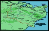
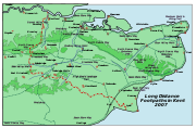
 Leave Gravesend
and cross the A2 at Tollgate, on through Sole Street and Luddesdown
climbing to the North Downs Way
at Trottiscliffe
. Descend the scarp slope of the North Downs
, cross the M20
and A20, go through Platt
, and Mereworth Woods to Gover Hill, where the Medway valley
comes into view. Down to West Peckham
, Barnes Street and thus to the Medway. The way now takes the riverside path upstream for a full 6 miles (9.7 km), through Tonbridge
to Hayesden, where it heads due south, under the railway and under the Tonbridge bypass climbing to the ridge at Bidborough
and through to Modest Corner, Southborough
. From here to the A264, at Stone Cross, the route follows a mixture of paths and roads. You now leave Kent, and follow the contour before dropping down into the upper Medway valley and on to Withyham
. The path follows a metalled drive, with good views to the north and south, leading to Five Hundred Acre Wood
, the setting of A. A. Milne
's, Christopher Robin
and Winnie the Pooh books. The wood was first enclosed in 1693, and the path dedicated as a right of way, by the owner in 1970. The path still rises to Greenwood Gate Clump, at the top of the Ashdown Forest
720 ft (219.5 m) above mean sea level, then on high ground to Camp Hill and on to Browns Brook Cottage. Now on to Buxted Park, Uckfield
, round Blackboys, with its Youth Hostel, East Hoathly through Chiddingly
to Gun Hill walking through arable
and pasture
interspersed with coppices. The path descends into the Cuckmere valley at Hellingly
through to the A22
south of Horsebridge. Now Upper Dicker and the River Cuckmere
to Arlington
and to Wilmington, East Sussex and the 226 ft (68.9 m) high chalk figure, the Long Man
. The path climbs then falls towards Jevington, and climbs to Willingdon Hill, 659 ft (200.9 m) Here, it is 2 miles (3.2 km) downhill to the Eastbourne
Youth Hostel on the A259
.
Kent
Kent is a county in southeast England, and is one of the home counties. It borders East Sussex, Surrey and Greater London and has a defined boundary with Essex in the middle of the Thames Estuary. The ceremonial county boundaries of Kent include the shire county of Kent and the unitary borough of...
and East Sussex
East Sussex
East Sussex is a county in South East England. It is bordered by the counties of Kent, Surrey and West Sussex, and to the south by the English Channel.-History:...
, is a public footpath that runs from Gravesend
Gravesend, Kent
Gravesend is a town in northwest Kent, England, on the south bank of the Thames, opposite Tilbury in Essex. It is the administrative town of the Borough of Gravesham and, because of its geographical position, has always had an important role to play in the history and communications of this part of...
, Kent
Kent
Kent is a county in southeast England, and is one of the home counties. It borders East Sussex, Surrey and Greater London and has a defined boundary with Essex in the middle of the Thames Estuary. The ceremonial county boundaries of Kent include the shire county of Kent and the unitary borough of...
on the Thames estuary, to the A259 at Eastbourne
Eastbourne
Eastbourne is a large town and borough in East Sussex, on the south coast of England between Brighton and Hastings. The town is situated at the eastern end of the chalk South Downs alongside the high cliff at Beachy Head...
, 3 km north of Beachy Head
Beachy Head
Beachy Head is a chalk headland on the south coast of England, close to the town of Eastbourne in the county of East Sussex, immediately east of the Seven Sisters. The cliff there is the highest chalk sea cliff in Britain, rising to 162 m above sea level. The peak allows views of the south...
.
Weald
The Weald is the name given to an area in South East England situated between the parallel chalk escarpments of the North and the South Downs. It should be regarded as three separate parts: the sandstone "High Weald" in the centre; the clay "Low Weald" periphery; and the Greensand Ridge which...
, providing a link between the routes north of the Thames and the start of the South Downs Way
South Downs Way
The South Downs Way is a long distance footpath and bridleway running along the South Downs in southern England, and is one of 15 National Trails in England and Wales...
. It would also provide a return circuit for users of the Saxon Shore Way
Saxon Shore Way
The Saxon Shore Way is a long-distance footpath in England, starting at Gravesend, Kent and traces the coast as it was in Roman times as far as Hastings, East Sussex, in total.-History:...
. The first route descriptions were published in the mid seventies, but the poor state of the rights of way between Uckfield
Uckfield
-Development:The local Tesco has proposed the redevelopment of the central town area as has the town council. The Hub has recently been completed, having been acquired for an unknown figure, presumed to be about half a million pounds...
and Eastbourne
Eastbourne
Eastbourne is a large town and borough in East Sussex, on the south coast of England between Brighton and Hastings. The town is situated at the eastern end of the chalk South Downs alongside the high cliff at Beachy Head...
delayed publication until 1981. Motorway Construction work and the building of the Tonbridge Flood Relief Barrier forced many changes to the original route.
Route
Gravesend, Kent
Gravesend is a town in northwest Kent, England, on the south bank of the Thames, opposite Tilbury in Essex. It is the administrative town of the Borough of Gravesham and, because of its geographical position, has always had an important role to play in the history and communications of this part of...
and cross the A2 at Tollgate, on through Sole Street and Luddesdown
Luddesdown
Luddesdown is a civil parish in the Gravesham District of Kent, England. This very rural parish, forming part of the North Downs Area of Outstanding Natural Beauty, is located in a dry valley to the south of Gravesend and is named after a scattered group of houses and farms around Luddesdown...
climbing to the North Downs Way
North Downs Way
The North Downs Way is a long-distance path in southern England, opened in 1978. It runs from Farnham to Dover, past Godalming, Guildford, Dorking, Merstham, Otford and Rochester, along the Surrey Hills Area of Outstanding Natural Beauty and Kent Downs AONB.East of Boughton Lees, the path splits...
at Trottiscliffe
Trottiscliffe
Trottiscliffe , is a village in Kent, England about north west of West Malling.Its most notable feature is the neolithic long barrow known as the Coldrum Stones and its medieval church. It is often incorrectly spelled Trosley after Trosley Country Park at the top of The North Downs, which was once...
. Descend the scarp slope of the North Downs
North Downs
The North Downs are a ridge of chalk hills in south east England that stretch from Farnham in Surrey to the White Cliffs of Dover in Kent. The North Downs lie within two Areas of Outstanding Natural Beauty , the Surrey Hills and the Kent Downs...
, cross the M20
M20 motorway
The M20 is a motorway in Kent, England. It runs from the M25 motorway to Folkestone, providing a link to the Channel Tunnel and the ports at Dover. It is long...
and A20, go through Platt
Platt, Kent
Platt, or St. Mary's Platt is a village in the local government district of Tonbridge and Malling in Kent, England. The village contains a church which was built in 1843 and which stands on a hill overlooking the village centre. The architects were Whichcord and Walker of Maidstone.The hamlet of...
, and Mereworth Woods to Gover Hill, where the Medway valley
River Medway
The River Medway, which is almost entirely in Kent, England, flows for from just inside the West Sussex border to the point where it enters the Thames Estuary....
comes into view. Down to West Peckham
West Peckham
West Peckham is a village in the local government district of Tonbridge and Malling in Kent, England. The River Bourne flows through the extreme west of the parish, and formerly powered a paper mill and corn mill . The Wateringbury Stream rises in the parish...
, Barnes Street and thus to the Medway. The way now takes the riverside path upstream for a full 6 miles (9.7 km), through Tonbridge
Tonbridge
Tonbridge is a market town in the English county of Kent, with a population of 30,340 in 2007. It is located on the River Medway, approximately 4 miles north of Tunbridge Wells, 12 miles south west of Maidstone and 29 miles south east of London...
to Hayesden, where it heads due south, under the railway and under the Tonbridge bypass climbing to the ridge at Bidborough
Bidborough
Bidborough is a village and civil parish in the borough of Tunbridge Wells in Kent, England, north of Tunbridge Wells and south of Tonbridge. According to the 2001 census it had a population of 958....
and through to Modest Corner, Southborough
Southborough
Southborough is the name of several places:* Southborough, Bromley in London, England* Southborough, Kingston upon Thames in London, England* Southborough, Kent in England* Southborough, Massachusetts in the USA** Southborough...
. From here to the A264, at Stone Cross, the route follows a mixture of paths and roads. You now leave Kent, and follow the contour before dropping down into the upper Medway valley and on to Withyham
Withyham
Withyham is a village and large civil parish in the Wealden district of East Sussex, England. The village is situated 10 miles south west of Tunbridge Wells and 3.5 miles from Crowborough; the parish covers approximately .-Geography:Withyham parish lies on the edge of Weald, in the...
. The path follows a metalled drive, with good views to the north and south, leading to Five Hundred Acre Wood
Hundred Acre Wood
The Hundred Acre Wood is the fictional land inhabited by Winnie-the-Pooh and his friends in the Winnie-the-Pooh series of children's stories by author A. A. Milne...
, the setting of A. A. Milne
A. A. Milne
Alan Alexander Milne was an English author, best known for his books about the teddy bear Winnie-the-Pooh and for various children's poems. Milne was a noted writer, primarily as a playwright, before the huge success of Pooh overshadowed all his previous work.-Biography:A. A...
's, Christopher Robin
Christopher Robin
Christopher Robin is a character created by A. A. Milne, appearing in his popular books of poetry and stories about Winnie-the-Pooh. He has subsequently appeared in Disney cartoons....
and Winnie the Pooh books. The wood was first enclosed in 1693, and the path dedicated as a right of way, by the owner in 1970. The path still rises to Greenwood Gate Clump, at the top of the Ashdown Forest
Ashdown Forest
Ashdown Forest is an ancient area of tranquil open heathland occupying the highest sandy ridge-top of the High Weald Area of Outstanding Natural Beauty. It is situated some south of London in the county of East Sussex, England...
720 ft (219.5 m) above mean sea level, then on high ground to Camp Hill and on to Browns Brook Cottage. Now on to Buxted Park, Uckfield
Uckfield
-Development:The local Tesco has proposed the redevelopment of the central town area as has the town council. The Hub has recently been completed, having been acquired for an unknown figure, presumed to be about half a million pounds...
, round Blackboys, with its Youth Hostel, East Hoathly through Chiddingly
Chiddingly
Chiddingly is a village and civil parish in the Wealden District of East Sussex, some five miles northwest of Hailsham. The parish is rural in character: it includes the village of Chiddingly and a collection of hamlets: the largest of these being Muddles Green and Thunder's Hill; others...
to Gun Hill walking through arable
Arable land
In geography and agriculture, arable land is land that can be used for growing crops. It includes all land under temporary crops , temporary meadows for mowing or pasture, land under market and kitchen gardens and land temporarily fallow...
and pasture
Pasture
Pasture is land used for grazing. Pasture lands in the narrow sense are enclosed tracts of farmland, grazed by domesticated livestock, such as horses, cattle, sheep or swine. The vegetation of tended pasture, forage, consists mainly of grasses, with an interspersion of legumes and other forbs...
interspersed with coppices. The path descends into the Cuckmere valley at Hellingly
Hellingly
Hellingly is a village and civil parish in the Wealden District of East Sussex, England. The village is located 1.5 miles north of Hailsham.The nearby village of Lower Dicker is located within the parish.-History:...
through to the A22
A22 road
The A22 is one of the two-digit major roads in the south east of England. It carries traffic from London to Eastbourne on the East Sussex coast...
south of Horsebridge. Now Upper Dicker and the River Cuckmere
River Cuckmere
The River Cuckmere rises near Heathfield in East Sussex, England on the southern slopes of the Weald. The name of the river probably comes from an Old English word meaning fast-flowing, since it descends over 100 m in its initial four miles...
to Arlington
Arlington, East Sussex
Arlington is a village and civil parish in the Wealden district of East Sussex. The parish is on the River Cuckmere, and is the location for a medieval priory, a reservoir and car racetrack.-History:The area has been settled since Anglo-Saxon times...
and to Wilmington, East Sussex and the 226 ft (68.9 m) high chalk figure, the Long Man
Long Man of Wilmington
The Long Man of Wilmington is a hill figure located in Wilmington, East Sussex, England on the steep slopes of Windover Hill, northwest of Eastbourne. The Long Man is tall and designed to look in proportion when viewed from below....
. The path climbs then falls towards Jevington, and climbs to Willingdon Hill, 659 ft (200.9 m) Here, it is 2 miles (3.2 km) downhill to the Eastbourne
Eastbourne
Eastbourne is a large town and borough in East Sussex, on the south coast of England between Brighton and Hastings. The town is situated at the eastern end of the chalk South Downs alongside the high cliff at Beachy Head...
Youth Hostel on the A259
A259 road
The A259 is a busy road on the south coast of England passing through Hampshire, West Sussex, East Sussex and part of Kent. Part of the road was named "the most dangerous road in South East England" in 2008.-Description:...
.